#arcmap
Explore tagged Tumblr posts
Visit Tumblr Blog
Explore Tumblr blogs with no restrictions, modern design and the best experience.
Last Seen Tumblr Blogs


Fun Fact
Tumblr.com rank in the US is 25.
Text
Highlight of my day: sitting, watching ArcPro load
3 notes
·
View notes
Text
🔥 Belajar SIG & Raup Cuan! Kursus QGIS + ArcMAP, Bisa Jadi Reseller!
Mau paham QGIS & ArcMAP dari nol dan langsung praktik? ✨ Plus, kamu bisa dapat penghasilan tambahan dengan
jadi reseller dan komisi 50%! 📉 Diskon 50-75% sekarang, yuk daftar!
#QGISIndonesia#ArcMAP#KursusSIG#PelatihanGIS#GISUntukPemula#SideHustle#BelajarOnline#Komisi50Persen#DiskonKursus#KursusTerbaik
0 notes
Text
Esri User Conference 2024: The world’s largest GIS conference (July 15–19, 2024 | San Diego, California).
iSpatial Techno Solutions (IST) will be exhibiting at the Esri User Conference 2024 in San Diego, CA. This event gives an opportunity for IST as we showcase our cutting-edge GIS and AI solutions that are shaping the future of sustainability and energy.

Sustainable Innovation

At IST, our commitment to sustainability drives our innovation. We are leveraging Esri's powerful GIS technology to develop solutions that help communities and organizations achieve their sustainability goals. Our advanced tools enable precise environmental monitoring, helping local and city governments to make informed decisions that promote ecological balance and resource conservation.
Leading Grid Modernization

The utility and energy sectors are evolving, and IST is at the forefront with Esri's Utility Network solution. Our expertise enhances operational efficiency, service reliability, and infrastructure management. We help utility providers optimize networks, reduce outages, and meet the demand for clean energy.
Advancing with Geo AI and Generative AI

They have a pioneering approach integrates Geo AI and Generative AI to convert data into actionable intelligence. These technologies offer local and city governments unparalleled insights, enabling them to tackle complex urban challenges effectively. From predictive analytics to real-time data visualization, our AI-driven solutions provide the essential tools for proactive decision-making and strategic planning.
Visit IST at Esri UC 2024
Join IST at Booth 1113 at Esri UC 2024 to discover how IST's solutions are making an impact. Engage with our experts to learn about our projects, experience live demonstrations of our technologies, and explore collaboration opportunities to drive sustainability and innovation in your organization.
Stay connected with IST on social media live updates, exclusive content, and behind-the-scenes insights from the conference.
If you want to work together to shape a sustainable and intelligent future. For more information, visit our website or contact us directly at [email protected].
We look forward to meeting you at Esri UC 2024!
#esri uc 2024#Esri user conference#Esri user conference 2024#esri uc#ArcGIS Utility Network#GIS#GEOAI#Geo analytics#Location Intelligence#ArcGIS enterprise#Esri#Geospatial#ArcFM#Asset Management#Geodatabase#ArcMap#Geometric#ArcGIS Pro#Web App Builder
1 note
·
View note
Text
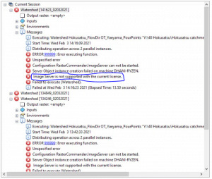
Pesan Kesalahan "Image Server is Not Supported with Current License" Di ArcMap
Salah satu masalah yang mengganggu dengan tool analysis tools di arc toolbox pada toolbox Spatial Analyst Tools/Hydrology adalah, “Image Server is not supported with the current license error” sebagai berikut. Spatial Analyst Error Masalah ini dapat diselesaikan dengan mudah menggunakan cara berikut ini: nonaktifkan fitur Parallel Processing (Parallel Processing seharusnya meningkatkan kecepatan…
View On WordPress
0 notes
Text
this is an arcmap hate blog. Fuck arcmap.
Also the Versioned SDE. Fuck the versioned SDE
1 note
·
View note
Text
Recursos: Macro ArcMap para mover una entidad por coordenada
Mientras aprendo a usar ArcMap, traigo un pequeño código para una tarea que daba por imposible de hacer aparte de forma manual: Mover una entidad.
ArcMap se ha vuelto una pesadilla. Es una herramienta muy útil, pero usarlo requiere muchísimo trabajo manual y repetitivo, así que voy a investigar como ir automatizando algunas tareas, sea mediante programar por mi cuenta o usando inteligencia artificial. Para empezar, traigo un pequeño código para una tarea que ya estaba dando como imposible de forma programática: Mover una entidad de un punto…
View On WordPress
0 notes
Text
Bc this brought me joy so I want to have it here
#.brain sees oscar do a happy little dance#.brain also does happy little dance#.jay does happy little dance and then goes back to fighting w fucking arCMAP#oscar piastri#lv gp 2024#las vegas gp 2024#video
32 notes
·
View notes
Text
Its so weird seeing a post go viral that I specifically have a lot of knowledge on, like why are these bitches fighting? Stop using Esri products and use QGIS and vector AND raster data xx
Also I hate to say this but Professor B is fighting an uphill battle. Girl I like arcmap too its much nicer to use but it's nowhere ear industry standard. The other guy is probably right for showing you arcgis.
oh yeah have i ever told yall of the academic war i have been an unwilling soilder in for the past two years
#Tbf I p much use raster mostly lol but that's just bc of work#I've used both all the time#Arcmap and arcscene are fun though bc they streamline the process a lot
175K notes
·
View notes
Text
Sometimes you just need to threaten arcmap into working by opening the task manager
#i still use arcmap for a lot of my work yes i know i should be long switched over to arcpro by now but#i know how to deal with arcmaps problems and quirks
1 note
·
View note
Text
🔥 Belajar QGIS 3 & ArcGIS ArcMAP 10 dari NOL sampai PRO! Diskon 50-75%, Bisa Jadi Reseller Komisi 50%!
Mau jago QGIS & ArcGIS tanpa ribet? 🚀 Kursus ini cocok buat pemula sampai mahir! Dapatkan diskon 50-75% dan kesempatan jadi reseller dengan komisi 50%. 💰 Ayo mulai sekarang!
0 notes
Text
If nobody ever hears from me again it's because I fell down an endless nightmare rabbit hole of trying to make nice feature labels in ArcMap that are arranged how I want them. For the record.
#seldon's offline existence#i love arcmap but there are days i think it was designed by a committee of spiral avatars
0 notes
Text
I've been cross refrencing gps data all week and my eyeballs are tired of looking at arcGIS on its crappy desktop application (which may just be crappy due to the allowed version my work is authorized to use)
Friendship ending with ArcMap and GoogleEarth Pro is my new best friend
#howl.txt#i also domt have the patience to learn how to properly use arcmap unless absolutely necessary T___T
0 notes
Text
Fed community, if you're out there, do you think that the BPRD from hellboy owns land. Like do they have haunted sites they manage. They probably own the land they have bases on. One of them is in Colorado.
I have ideas for a BPRD oc but I'm of course always paralyzed by "what if this isnt accurate enough" type beat.
I'd imagine that if an organization owns land, like the USFS or BLM or heck even the DoD, they have land managers. And if there are trees on that land they probably have foresters. And if they have foresters they probably have GIS workers. You see where I'm going with this?
PARANORMAL GIS/DATABASE MANAGEMENT
Also are they subject to NEPA? Do they need NEPA compliance officers? What kind of paranormal activity might a GIS team be good to have around? At least they need a database management team.
Head's buzzing with ideas. They're most certainly underfunded. Probably worse than the Forest Service. In 2012 they're still working with ArcMap 2004 or something. Probably have someone on call as a "techxorcist" to purge the databases of inevitable evil spirits.
Maybe they have specific python programs to run "pentagram triangulation" or something like that. Someone's gotta figure out if the house is actually bigger on the inside than the outside. Who better than a specialized survey team?
Also what kind of paranormal abilities might people have to land them working in GIS? Probably just weak stuff that makes them less suitable for field ops. Or things that might dissuade them from working at a different federal agency. Like if you have glowing skin maybe you'd be better off working database for the BPRD than for the BLM.
I came up with a silly name: Unit 66
Because of 666, and because a surveyor's chain is 66 feet.
14 notes
·
View notes
Text
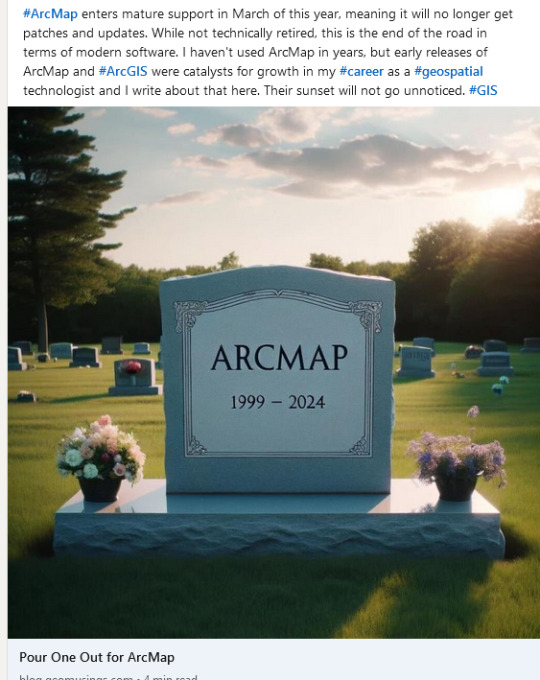
I will not be pouring one out for ArcMap, I will be pissing on ArcMap's grave. Fuck ArcMap, I fucking hate Arcmap.
#this is not at all influenced by having to teach my college cartography class to use ArcPro while the assignments are written for Arcmap#Fuck arcmap#arcmap#GIS#mapping
0 notes

Text
If ArcMaps teaches you anything it’s to make sure you name your damn files correctly
12 notes
·
View notes