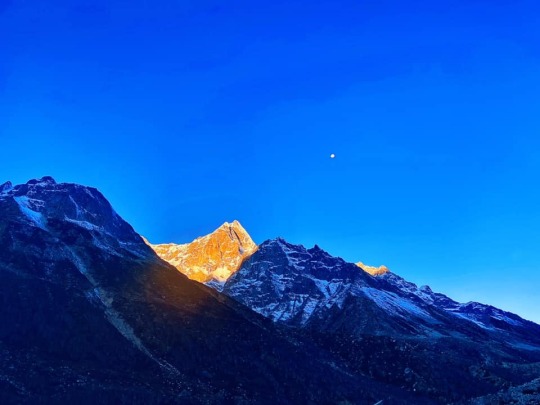
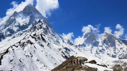
#bhojbasa
Photo


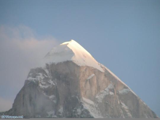
yātra: GOMUKH. THE SOURCE. exhilarating to be here and to do Pūjā to Gaṅgā Devī here together. ecstatic and beyond words.
#sabdacara#yatra#sabda yatra#gomukh#gangotri#india#himalayas#indian himalayas#ganga#ganga devi#ganges#bhojbasa#uttarkashi#kashi#uttarkhand#shivalinga#mahadeva#har har gange#har har mahadev#india travel#pilgrimage#sabda institute#kavitha chinnaiyan#puja#worship#devi
1 note
·
View note
Text
Gaumukh Tapovan Trek: A Spiritual and Scenic Himalayan Journey
Introduction to Gaumukh Tapovan Trek
The Gaumukh Tapovan trek is a spiritual and scenic trek in the Garhwal Himalayas of Uttarakhand, India. It takes you to the source of the Ganges River at Gaumukh and the high-altitude meadow of Tapovan, offering stunning views of snow-capped peaks and a chance to witness the spiritual essence of the Himalayas.
Planning Your Gaumukh Tapovan Trek
Best Time to Visit
The best time to undertake the Gaumukh Tapovan trek is during the summer months, from May to June, and then again in the post-monsoon season, from September to October. These months offer the best weather conditions for trekking, with clear skies and pleasant temperatures.
Permits and Permissions
Before starting your trek, make sure to obtain the necessary permits and permissions from the forest department. These permits are required to enter the Gangotri National Park, which falls along the trekking route.
Physical Fitness and Training
The Gaumukh Tapovan trek is a challenging trek that requires a good level of physical fitness. It is advisable to undertake some form of physical training before embarking on the trek, such as hiking, jogging, or cycling, to prepare your body for the rigors of the trek.
Packing Essentials
When packing for your Gaumukh Tapovan trek, make sure to carry essential items such as sturdy trekking shoes, warm clothing, a sleeping bag, a first-aid kit, and enough food and water to last the duration of your trek. It is also advisable to carry a map and a compass to navigate the trail.
Trek Itinerary
The Gaumukh Tapovan trek typically takes around 4-5 days to complete, depending on your pace and the route taken. The trek starts from Gangotri and takes you through lush forests, charming villages, and scenic meadows, before culminating at the stunning Tapovan meadow.
Day 1: Reach Gangotri
Day 2: Trek from Gangotri to Bhojbasa
Day 3: Trek from Bhojbasa to Gaumukh and Tapovan
Day 4: Explore Tapovan and Return to Gangotri
Embark on the spiritual and scenic journey of a lifetime with the Gaumukh Tapovan trek. Experience the beauty and grandeur of the Himalayas like never before, and create memories that will last a lifetime.
FAQs (Frequently Asked Questions)
Is the Gaumukh Tapovan trek suitable for beginners?
Yes, the Gaumukh Tapovan trek is suitable for experienced trekkers with a good level of physical fitness.
What is the best time to undertake the Gaumukh Tapovan trek?
The best time to undertake the Gaumukh Tapovan trek is during the summer months, from May to June, and then again in the post-monsoon season, from September to October.
What is the altitude gain during the Gaumukh Tapovan trek?
The altitude gain during the Gaumukh Tapovan trek is gradual, with the highest point being the Tapovan meadow, which is at an altitude of around 14,200 feet above sea level.
Are there any medical facilities available along the trekking route?
Medical facilities along the trekking route are limited, so it is advisable to carry a basic first-aid kit with you. In case of emergencies, there are medical facilities available in the nearby villages, but they may be basic.
Is it safe to undertake the Gaumukh Tapovan trek alone?
While it is possible to undertake the Gaumukh Tapovan trek alone, it is always advisable to trek in a group, especially for inexperienced trekkers. Trekking in a group ensures safety and provides a support system in case of emergencies.
0 notes
Text
Embarking on a Soul-Stirring Adventure: The Gaumukh Tapovan Trek
Introduction:
Nestled in the serene state of Uttarakhand, the Gaumukh Tapovan trek is a journey that beckons adventure enthusiasts and nature lovers alike. This mystical trek takes you on a mesmerizing expedition through the heart of the Garhwal Himalayas, offering breathtaking views of snow-capped peaks, glistening glaciers, and sacred rivers. So, fasten your backpacks, as we unravel the enchanting tale of the Gaumukh Tapovan trek.
The Starting Point: Gangotri - A Gateway to Divinity
The spiritual town of Gangotri, situated at an altitude of 3,415 meters, serves as the starting point for the trek. Steeped in mythology and folklore, Gangotri is where the holy River Ganges finds its source, known as Gaumukh. Before you begin your ascent, take a moment to seek blessings at the Gangotri Temple, dedicated to the Goddess Ganga.
Day 1: Gangotri to Chirbasa - A Glimpse of the Wilderness
The trek commences with a moderate walk from Gangotri to Chirbasa, covering a distance of approximately 9 kilometers. The trail meanders along the Bhagirathi River, offering glimpses of picturesque landscapes and the occasional sightings of Himalayan wildlife. Chirbasa, nestled at an elevation of 3,660 meters, is adorned with lush green meadows and birch trees, providing the perfect spot for the first night's camp.
Day 2: Chirbasa to Bhojbasa - The Magnificent Gaumukh Glacier
On day two, the trek takes you from Chirbasa to Bhojbasa, a trekking distance of around 5 kilometers. As you move closer to the glacier, the air becomes crisper, and the scenery more dramatic. The highlight of the day is the awe-inspiring Gaumukh Glacier, where the Ganges originates from a cow-shaped crevasse, adding a touch of divine mystique to the journey.
Day 3: Bhojbasa to Gaumukh to Tapovan - An Ascent to Eternity
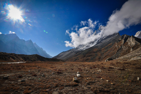
The most thrilling leg of the journey unfolds on day three. After a steep climb from Bhojbasa, you'll arrive at the majestic Gaumukh, a sight to behold. Witnessing the birth of the Ganges amidst the towering peaks is an overwhelming experience, filling your heart with a sense of awe and reverence. From Gaumukh, the trail continues to Tapovan, an exquisite high-altitude meadow at 4,463 meters, surrounded by the magnificent peaks of Shivling, Meru, and Bhagirathi.
Day 4: Tapovan - Unraveling the Spiritual Essence
Day four is dedicated to immersing yourself in the spiritual ambiance of Tapovan. Surrounded by snow-clad peaks, you'll find tranquility and solitude at its best. The place has a significant presence in Hindu mythology, believed to be the meditation site of ancient sages. Spend the day meditating, exploring, and capturing the raw beauty of this heavenly abode.
Day 5: Tapovan to Bhojbasa to Gangotri - A Journey's End
With a heavy heart, bid farewell to Tapovan and start descending to Bhojbasa. Take one last look at the mesmerizing landscape before continuing back to Gangotri. The descent allows you to reflect on the magnificent journey, leaving you with memories that will last a lifetime.
Conclusion:
A Trek Beyond Ordinary The Gaumukh Tapovan trek is not just a physical journey but a spiritual odyssey that connects you with the divine splendor of the Himalayas. From the sacred source of the Ganges to the serene expanse of Tapovan, every step on this trail unfolds the untamed beauty of nature. So, if you seek adventure, serenity, and a transformative experience, the Gaumukh Tapovan trek in Uttarakhand is an expedition beyond ordinary, awaiting your footsteps amidst the enchanting Himalayas.
0 notes
Text
One of Most Rewarding Trek! : Gaumukh Tapovan Trek
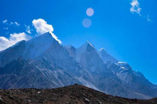
The Gaumukh Tapovan trek is an eight-day trek with ardent gifts of Mother Nature. It offers the best scenery perfect for adventure seekers. The main attraction here is the Gangotri Glacier that’s believed to be the mouth of River Ganga. This glacier is about 2.4 km wide and 30 km long that starts from Gaumukh and extends towards Chaukhamba massif near Badrinath. The top view offers a beautiful view of the backdrop of Mount Shivling. Vast green meadows are an ideal spot for camping. Shivling watches other stunning peaks like Bhagirathi twin peaks, and Mount Meru.
Gaumukh in English means “Cow’s mouth.” It’s one of the largest in the Himalayas with 27 cubic kilometers of volume. The famous area Gangotri Glacier and the Tapovan are popular tourist attractions. This area serves as the base camp for many mountaineers. Under Gaumukh Tapovan trek package comes lush green meadows, blooming flowers, and several streams cover this area. Gaumukh stands at a height of 14,202 feet. Trek difficulty is moderate, best for people between 12 to 45 years of age group. The total trek distance is 46 km. This trek is like a new generation trek. A perfect place to shoot a movie.
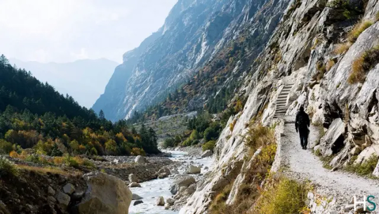
After checking the Gaumukh Tapovan trek package cost, as you start your journey you’ll come across Tehri Dam that generates 2400 MW of electricity. Moving further, watch the massive Tehri Lake. While reaching the base camp, get a view of the greater Himalayas, Harshil, and deep green forests. The next spot, Chirbasa offers magnificent beauty. It’s also called the “abode of pine trees” with admiring forests and valleys below. Walk amidst the trees with huge mountains accompanying you side by side. You can rest for a while under the shed. Camp along the riverside and feel the freshness of nature laying upon the vast meadows. Camp at Bhojbasa is the wildest spot on the upper valley. And the feel of the moonlit stars above at night. An incredible sight one can experience. Further, there lies a small temple. You can pay your respect to the temple. Enjoy the view of the Shiv Ling peak at every step. Watch the change of landscapes as you trek.
Pass through the narrow valley along the riverside over the green meadows. After a few kilometers, the trails turn into a rocky path. Most of the adventures start here. Walk on the rocks and granites along a sandy beach with granite stones. Camp at the beach to feel a unique experience. Follow the broken path to reach the foot of Gaumukh. There is a steep climb after this for 1000 feet that reaches you at Shivling peak base. Spot a few Babas here who are dedicated to Lord Shiva. Below Mount Shivling falls Tapovan; a high-altitude alpine meadow. It spreads for over 2 km in length. All areas here aren’t good for camping. The area near Mount Shivling remains wet during the peak of summer due to glaciers and melted snow. This area served as the meditating place for many sages. Several sages and holy men are still residing in Tapovan. The River Ganga is considered the most sacred in terms of Hindu mythology. It is the holy water of the Hindus. She came down to earth to offer new lives to men. The channel’s name is Bhagirathi whose enormous energy is controlled by Lord Shiva himself.
Main Highlights of The Trek
Magnificent Summit Views
The best part is the magnificent summit views. The summit view offers a great close view of Mount Shivling. It’s a captivating sight perfect for nature photography. Mount Shivling is the most beautiful mountain in the Himalayas. This magnificent mountain is marked on the golden calendar every year. Except for Mount Shivling, you can also watch the Bhagirathi sisters from down to top. The whole of Shivling and Bhagirathi dominates the landscapes. You also get a view of Mount Meru upon which a mountaineering movie came out. Even watched Manda Parba as well. No other trek offers such a unique experience.
Gangotri Glacier and Gaumukh
Almost 90% of treks do not have glaciers. It’s quite difficult to see them. This trek offers India’s largest glaciers. You’ll be standing at the glaciers and it seems larger than your life. See the ice blocks melting and falling over the snow. The sounds come like a thunderstorm. A brilliant sight to experience. You can even create a slow-motion video out of it. Gaumukh is larger in magnitude than other treks. You cannot explore the whole of glaciers within just a few days. From this snout, the Bhagirathi River flows in full power. It’s a rare sight and feels like a blessing when you witness it. Strolling around the Gangotri glacier offers a different kind of adventure. You never know what is waiting for you next.
Change of Scenery
Keep a close look at the scenic colors. Colors keep on changing all over the trek. They change after every hour. Coniferous trees surround the whole trail path. Upon the barren earth, watch the formation of sandstones and rocks tumbling down. At every spot there is suspense and you’ll want to explore more. Trekking at Gaumukh feels like exploring real gold. Once at Tapovan, it’s a trekkers paradise. Be lost in the atmosphere. An ideal place for nature fanatics. It’s all about glaciers. This trek was one of India’s favorite treks.
Best Time To Visit Gaumukh Tapovan Trek?
The best time to visit the Gaumukh trek is during summers and post-monsoon. Summer means between May and June while post-monsoon is from September to October. During summers you can watch patches of snow starting from Chirbasa. Summers receive occasional rain. The temperature remains 18 to 22 degrees Celsius during the day. Nights are colder like around 2 to 3 degrees Celsius. Sometimes even zero degrees.
Post monsoon offers clear skies. A fantastic time to witness the sunrise and sunset over Mount Shivling. Trekking during this season is perfect. Chilly weather makes you fall in love with nature more. Daytime temperatures are 13 to 20 degrees Celcius and the nighttime temperature remains below zero degrees. So, don’t wait to check out Gaumukh Tapovan trek cost.
0 notes
Photo
https://gpstraces.net/randonnee-pedestre-inde-source-gange-bhojbasa-tapovanam-rando-186
0 notes
Text
Beware! These experiences may change you....forever!
.
This was during our acclimatization day of the Gaumukh Tapovan trek, moving from Bhojbasa campsite towards Gaumukh glacier.
.
In the background: The Bhagirathi sisters
.
#liftnwander
@indiahikes
.
#mountain #nature #travel #mountains #hiking #landscape #adventure #photography #naturephotography #outdoors #hike #explore #photooftheday #wanderlust #beautiful #sky #travelphotography #naturelovers #love #landscapephotography #ınstagood #view #sunset #travelgram #clouds #picoftheday #forest #lake
instagram
#mountains#himalayas#nature#travel#trek#hike#hiketheworld#adventure#travelling#tripotocommunity#alpine#hills#snow#snowpeak#Instagram
2 notes
·
View notes
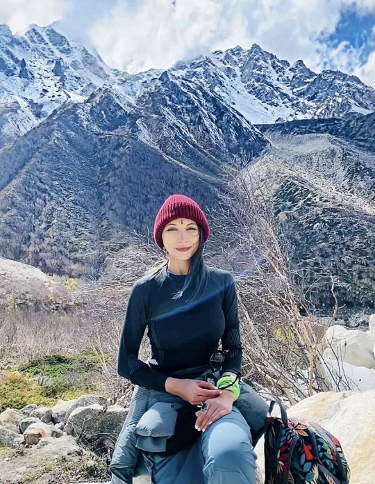
Photo
The belle of Bhojbasa #landscape #ngtindia #iamatraveler #lonelyplanetindia #travel #gothere #yourshotphotographer #somewheremagazine #suitcasetravels #littlerivermag #somewheremood #artofvisuals #cntgiveitashot #hellofrom #sidetrackedmag #dreamermagazine #worldviewmag #pasteltoned #n8zine #creativeimagemagazine #beautifuldestinations #solarcollective #landscapephotographymagazine #thislifemagazine #picoftheday #stademagazine #noxazure #artclassified #photooftheday #earth_deluxe (at Uttarakhand) https://www.instagram.com/p/B_H91GSpUBY/?igshid=1pjyhdqwlmjps
#landscape#ngtindia#iamatraveler#lonelyplanetindia#travel#gothere#yourshotphotographer#somewheremagazine#suitcasetravels#littlerivermag#somewheremood#artofvisuals#cntgiveitashot#hellofrom#sidetrackedmag#dreamermagazine#worldviewmag#pasteltoned#n8zine#creativeimagemagazine#beautifuldestinations#solarcollective#landscapephotographymagazine#thislifemagazine#picoftheday#stademagazine#noxazure#artclassified#photooftheday#earth_deluxe
2 notes
·
View notes
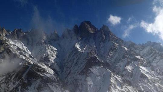
Photo
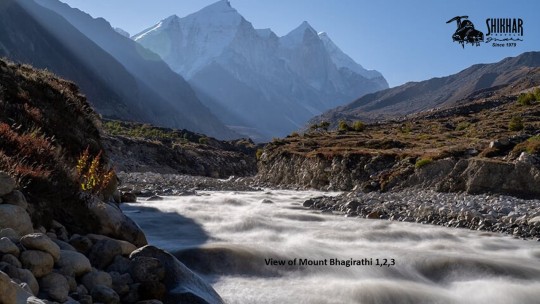
View of the three most 𝐩𝐨𝐩𝐮𝐥𝐚𝐫 𝐩𝐞𝐚𝐤𝐬 𝐨𝐟 𝐆𝐚𝐫𝐡𝐰𝐚𝐥 𝐇𝐢𝐦𝐚𝐥𝐚𝐲𝐚𝐬
#Bhagirathi II, III, and I (left to right, 6512m, 6454m, and 6856m), t stands at and dominates the end of the valley leading up to Gaumukh which is the end of the Gangotri Glacier and the source of the river Ganga.
𝐑𝐨𝐮𝐭𝐞: Delhi - Rishikesh - Uttarkashi - Gangotri - Chirbasa - Bhojbasa - Gaumukh (3892M) - Nandanvan BC (4340 M) - Bhagirathi Summit (6512 M) - Nandanvan BC (4340 M) - Bhojbasa Gangotri Uttarkashi - Rishikesh - Delhi
𝐁𝐞𝐬𝐭 𝐓𝐢𝐦𝐞: May, June, September, October
#mtbhagirathi#Gangotri#Gaumukh#climbing#adventure#GarhwalHimalayas#Indianhimalayas#redbulladvnture#mountains#rishikesh#mtkedardome#photography#mtsatopanth#mtshivling#hiking#snow#travel#shikhartravels
1 note
·
View note
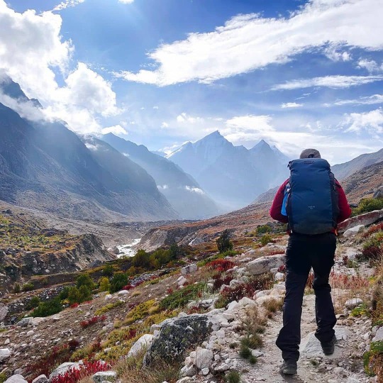
Video
One the way to #bhojbasa . Timing: 4.29pm Date: 16/10/2017 #highaltitude #trekking #gangotripeaks #groupofpeaks #pahaditours #adventure #himalayas #haimalayanbeauty #nationpark #worldharitagesite #indiatourism #uttarakhandtourism #india #asia #worldpeace (at Gangotri National Park)
#worldharitagesite#bhojbasa#groupofpeaks#uttarakhandtourism#asia#worldpeace#indiatourism#pahaditours#gangotripeaks#trekking#adventure#haimalayanbeauty#nationpark#india#highaltitude#himalayas
0 notes
Text
Inimitable Gangotri Gomukh Tapovan Trek
Are you an adventure aficionado looking for some fascinating trekking expedition in the Indian Himalayas? We're here to help you with! You can opt for Gangotri Gomukh Tapovan Trek. Located in Garhwal Himalayan region, this gratifying trek is famed for offering refreshing vistas to the trekkers.
Where is it located
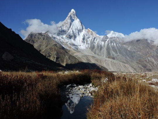
Gangotri-Gaumukh Tapovan trek is a popular trek in the Garhwal Himalayas, Uttarakhand. This trek is located at the base of the Gangotri glacier. The sight of Bhagirathi sisters glistening in the moonlight from Bhojbasa and from Tapovan is mesmerizing, Mt Shivling rises from its base all the way to its summit.
Gaumukh is a sight on its own. Only when you get closer to it, magnificent the glacier is!
Grade
Gangotri Gomukh Tapovan Trek ranges between Moderate to Challenging experience during the expedition.
Duration
It is a 12days trek trip exploring the altitude of 4463 mts /14638 ft.
Best time to take the trip
The best time to do Gomukh trek is in between May to June and mid-Aug to Oct.
This trek involves a gradual descent and a series of level walks, which can be done swiftly. The trek back to Gangotri is the same trail taken to reach Chirbasa. It is a gradual descent, which takes far less time to cover than the ascent.
#travel#trek#trekkies#trekken#trekkers#trekking#adventure#wanederlust#wanderlust#wander#explore#explorer
1 note
·
View note
Text
Trekking from Gangotri to Gomukh Glacier- 4250m Above Sea Level- Unforgettable Adventure
Trekking from Gangotri to Gomukh Glacier- 4250m Above Sea Level- Unforgettable Adventure
This video was shot during our visit to Gangotri and Gomukh in August 2007.
Trekking from Gangotri to Gomukh Glacier, Himalayan Trekking, The source of River Ganga, Gangotri to Gomuch, Chirbasa and Bhojbasa, Lal baba Ashram in Bhojbasa, Extreme cold temperature, floating ice, Hara hara Mahadev, Om Namah Shivay, Trekking from Gangotri to Gomukh Glacier- 4250m Above Sea Level- Unforgettable…
youtube
View On WordPress
0 notes
Photo


by Mahārājñī’s grace, my dream of India came true! for five years, it has been an ardent wish of mine to see these lands and i was blessed to answer to the call of the Himalayas by embarking on the most special, magnificent and expansive yātra. starting from Rishikesh, we traversed Uttarkashi, Gangotri, Bhojbasa, Gomukh, Barkot, Yamunotri, and returned to Rishikesh for our closing ceremony. we trailed and trekked the mountains in worship of Devī in her forms as Śrī Gaṅgā & Śrī Yamunā. it was a journey of cellular transformation: explosive insights, breath-taking beauty, moving softness, immersion in the love and flow of Gaṅgā Devī.
most miraculously, we completed the arduous and most fulfilling trek of 36 km from Gangotri to Gomukh, the source of the Holy Gaṅgā, in two intense & magical days! i have never felt more alive than on this trail, immersed in the hum of Devī Gaṅgā and held in the lap of the mountains. every step taken was a challenge to my self-imposed limitations and ideas of myself – of who i am, of what i can do and achieve. every step taken taught me resilience and determination, as well as showed me that my strength springs from my longing. it has been most sacred to complete this trail and to come to be at the Source. imbibing in Her exquisite vibrations, we worshipped Her through pūjā. we breathed, we smiled, we cried. i will remember this experience for the rest of my life with all the gratitude & awe my being can muster.
Śrī Mātre Namaḥ! Har Har Mahādeva! Hare Hare Gaṅge!!!
#ganga#ganga devi#mahadeva#ganges#yamuna#yamunotri#gomukh#sangha#guru#india#india travel#gangotri#himalayas#barkot#bharat#yatra#pilgrimage#sabda institute#uttarkhand#uttarkashi#rishikesh#trek
5 notes
·
View notes
Photo
23/09 After the horrific night, we were yet thrilled to see the glacier. Had black tea before breakfast. Repacked our bags, filled up our water bottles. Left Bhojbasa at around 8. Almost an hour later, we got into this beautiful patch with who knows what flowers, and them smooooooth rocks😌. Combine that with the view of the Bhagirathi sisters.❤️❤️ Another half an hour later we were in a beach, atleast it felt like one. In all this spine chilling landscape, as beautiful as it looks, one thing was eating me up. Look at the glacial line at almost one-third of the mountains on the left. At one time the glacier was at that level. . ⚠️150 years ago, there were 147 glaciers in Gangotri National Park, now ONLY 37 ARE LEFT.⚠️ . 🚨WHICH ARE LIKE TO MELT COMPLETELY BY 2030.🚨 . This was probably one of the most disheartening fact I have heard. * 📸 @thepeakfreak (DM for credit/removal) . Book Your Trekking & RoadTrip Package with us #thecrazymountaineers For any queries DM or Mail us. [email protected] * Lets Experience The Most Unexplored Region Of The Himalayas - You Can Also Be a Part Of Our Journey * @thecrazymountaineers #thecrazymountaineers #uttarakhandtradition #incredibleuttarakhand #gangotri #uttarakhanddiaries #trekking #devbhoomiuttarakhand #gangotrinationalpark #trekkingchile #uttarakhandheaven #uttarakhand_loversss #trekkingadventure #uttarakhand_beauty #uttarakhandpictures #uttarakhandbeauty #trekkinglovers #prilaga #uttarakhandtourism #poetsofindia #instatrekking #uttarakhandculture #uttarakhand_travel_diaries #uttarakhandtraveller #uttarakhandi #uttarakhand #uttarakhandvibes #weuttarakhand (at Gangotri National Park) https://www.instagram.com/p/CGRjIijJHFS/?igshid=12zelqdnze22t
#thecrazymountaineers#uttarakhandtradition#incredibleuttarakhand#gangotri#uttarakhanddiaries#trekking#devbhoomiuttarakhand#gangotrinationalpark#trekkingchile#uttarakhandheaven#uttarakhand_loversss#trekkingadventure#uttarakhand_beauty#uttarakhandpictures#uttarakhandbeauty#trekkinglovers#prilaga#uttarakhandtourism#poetsofindia#instatrekking#uttarakhandculture#uttarakhand_travel_diaries#uttarakhandtraveller#uttarakhandi#uttarakhand#uttarakhandvibes#weuttarakhand
0 notes
Text
Forest fire, tourism causing Gangotri Glacier to melt faster: Study - india news
New Post has been published on https://www.liveindiatimes.com/forest-fire-tourism-causing-gangotri-glacier-to-melt-faster-study-india-news/
Forest fire, tourism causing Gangotri Glacier to melt faster: Study - india news
The concentration of black carbon on Gangotri glacier has almost doubled in the past few years primarily because of the raging forest fires, said a research done by Dehradun-based Wadia Institute of Himalayan Geology.
PS Negi, a scientist at Wadia’s research group on ‘Geomorphology and Environmental Geology’ said they have been monitoring black carbon through two weather stations on way to Gangotri glaciers – namely Chirbasa station at a height of 3,600 m, and Bhojbasa station at a height of 3,800 m – for the last few years.
“Analysis of the data from these weather stations in real time has helped us to know about black carbon concentrations and seasonal variations in the higher Himalayas. We have found that the concentration of the black carbon increases in summer months due to varied factors. We have found a range of black carbon up to 4.62 micrograms per cubic metre,” he said.
In the non-summer months, the concentration comes down to about 2 micrograms per cubic metre of air indicating that forest fires and tourism activities in Uttarakhand contribute to higher concentration of black carbon on glaciers.
“Period from April to June showed remarkable increase in black carbon concentration primarily due to direct and indirect activities related to tourism. Also, forest fires contribute in increasing black carbon concentration. Also we found high black carbon concentration during September and October. The lowest black carbon concentration has been recorded during August followed by December, likely due to the absence of tourist activities and forest fire incidences during these months,” he said.
On the sources of black carbon, Negi said the main local sources of black carbon observed during field study include forest fires, domestic and commercial fuel wood burning and seasonal burning of crop residue.
According to Forest Survey of India, the forest fire activity is generally reported in Uttarakhand from February to June, with a peak in fire incidences in May and June. Besides man made, other reasons for forest fires in the state include lightning, friction of falling rocks and monkeys accidentally throwing stones that create sparks leading to forest fires. Over 44,554 hectares of forest area has been damaged in forest fires in Uttarakhand since its formation in 2000, according to the state forest department data.
On possible impact of the black carbon on Himalayan glaciers, Negi said, black materials absorb more light and emit infra-red radiation which increases the temperature. “So effectively, when there is an increase in black carbon in the higher Himalayas, it will contribute to faster melting of the Himalayan glaciers,” he said.
Negi said black carbon is a kind of an aerosol (an aerosol is a suspension of fine solid particles or liquid droplets). “Among aerosols, black carbon (BC) has been recognized as the second most important anthropogenic agent for climate change and the primary marker to understand the adverse effects caused by air pollution,” he said.
On the source of the black carbon in Himalayas, Negi said developmental activities, pollution from local, regional and global sources accumulate over the Himalayan region and increase the concentration of black carbon.
“Their presence in atmosphere also causes changes in weather pattern such as rain and snow precipitation pattern and local ecosystem and weather cycles. In the longer run, the changes in the atmospheric composition of the high Himalayan will affect the weather pattern, and accordingly natural resources and socio-economic activities of Himalayan communities”, he said.
Scientists at Dehradun-based Wadia Institute of Himalayan Geology monitor black carbon aerosol on real time basis through its monitoring stations and studies its impact on glaciers. The Central government institute also studies the impact of climate change on Himalayan glaciers in north-west India.
Source link
0 notes
Link
Trek Itinerary : GangotriDham with Gaumukh
Day 1 :
Haridwar to GuptkashiAltitude : 11,204 Ft.Time Taken : 10 hrs DriveOn this day you will head towards Gangotri from Haridwar, the journey will start early, and it will be a journey of 241 Km to Gangotri. The whole journey will be of 8 hrs besides mountains, and the way will pass from Mussoorie, the famous hills station encompasses by the Shivalik Range. Later the attractions in the way will be Dhanulti, Chamba and after crossing these, you will reach Uttarkashi. Uttarkashi the land of god that lies on the bank of the river Bhagirathi, you will be able to witness many temples along the way, later you will see the sight scenes of the Harshli village. The Harshil village is known for apple orchards everywhere that will treat your eyes better. As you move further after a long ride, you will reach Gangotri located on the bank of the Bhagirathi River, and you can stroll to the local market and admire the beauty of mountains. The network availability will be good there, so you can take pictures and upload them instantly.
Day 2 :
Gangotri to BhojbasaAltitude : 12,385 Ft.On this day trek to Bhojbasa from Gangotri. In the morning visit the shrine of Goddess Ganga. Start your trek and later you will realize that the vegetation is decreasing. As you continue trekking so you reach Chirbasa. In the way you get to cross some streams, as you reach Chirbasa so there are 5Km ahead is Bhojbasa alongside the Bhagirathi peak will be constantly visible in front of you.
Day 3 :
Bhojbasa to Gaumukh to Bhojbasa.Altitude: 13,200 Ft.On this day start your trek in the morning to Gaumukh from Bhojbasa. On arrival Gaumukh explore Gaumukh. Than trek down to Bhojbasa. Overnight stay in Bhojbasa. Gaumukh is where the waters of Ganga trickle down from the glaciers. The sages called it 'Gaumukh', because in the distant past, it probably appeared like a cow's mouth; though today it no longer appears so. The Gaumukh glacier is the source of Bhagirathi (Ganga) and is held in high esteem by the devouts who do not miss the opportunity to have the holy dip in the bone chilling icy water. It is 18 kms. From Gangotri. There is a Tourist Bungalow at Bhojbasa, 14 kms. From Gangotri where lodging and other facilities are available. From Gangotri we move along the beaten track towards Chirbasa, which is on the tree line. From here, we can get a clear view of the Bhagirathi Peak.
Day 4 :
Bhojwasa to Gangotri.Altitude: 12,385 Ft. to 11,204 Ft.On this day you will head towards Gangotri back from Bhojwasa as you have completed the whole trek. It would be better to wake up early so that you can cherish the few last moments in the holy mountains shining bright in front of you. As you will see Mt. Shivling looks magical, and connecting to other peaks and the whole mountains range looks Bewitching. Later on, have your breakfast and get ready to trek back to Gangotri from Bhojwasa, carry enough water bottles as you won't get any water sources in between. And the path will go like you have to cross the rocky terrain and moraines of the glacier. There will descend; you will come across boulders, so take step gradually and carefully.
Day 5 :
Gangotri to HaridwarTime Taken : 10 hrsOn this day the trek will be the end day as you drive back to Haridwar from Gangotri, have the final look over the mighty mountains with a sip of tea and say goodbye to the mountains. It will be of 8 hrs Drive from Gangotri. Collect the memories with you and the life experience with you in this journey of Gaumukh trek in Uttarakhand.Overview
Gangotri, a blessed Hindu pilgrimage is the source of river Ganga. Gangotri is a marvelous place which becomes highly packed during the months of May-June. Gaumukh means Cow's mouth and trek from Gangotri having a stable but gradual climb. Holy River Ganges and her tributaries flow from Char Dham that are located in Uttarakhand, India. It is believed that Goddess Ganga descended upon the Earth in the form of a River to help the suffering humanity. It was split into four channels that include Alaknanda, Mandakini, Bhagirathi, and Yamuna. Each is blessed with spellbinding scenic beauty and countless ancient temples. Every year, countless tourists from across the world, visit here in search of peace and tranquility. Gaumukh is also famous because of its mystery that no one has reached to its root phase till yet.
Altitude
The altitude of Gangotri Dham with Gaumukh Trek is 12,762 Ft. The trek will open up the glimpse of beautiful mountains around. The important thing that one has to keep in mind is to take the proper medication with them at the higher altitude. Though we provide every possible thing but it is always better to keep your medicines. Hydration is the most important part when you trek to the higher altitude, so keep your body hydrated while trekking.
0 notes
Text
Forest fire, tourism causing Gangotri Glacier to melt faster: Study - india news
The concentration of black carbon on Gangotri glacier has almost doubled in the past few years primarily because of the raging forest fires, said a research done by Dehradun-based Wadia Institute of Himalayan Geology.PS Negi, a scientist at Wadia’s research group on ‘Geomorphology and Environmental Geology’ said they have been monitoring black carbon through two weather stations on way to Gangotri glaciers - namely Chirbasa station at a height of 3,600 m, and Bhojbasa station at a height of 3,800 m - for the last few years.“Analysis of the data from these weather stations in real time has helped us to know about black carbon concentrations and seasonal variations in the higher Himalayas. We have found that the concentration of the black carbon increases in summer months due to varied factors. We have found a range of black carbon up to 4.62 micrograms per cubic metre,” he said.In the non-summer months, the concentration comes down to about 2 micrograms per cubic metre of air indicating that forest fires and tourism activities in Uttarakhand contribute to higher concentration of black carbon on glaciers.“Period from April to June showed remarkable increase in black carbon concentration primarily due to direct and indirect activities related to tourism. Also, forest fires contribute in increasing black carbon concentration. Also we found high black carbon concentration during September and October. The lowest black carbon concentration has been recorded during August followed by December, likely due to the absence of tourist activities and forest fire incidences during these months,” he said.On the sources of black carbon, Negi said the main local sources of black carbon observed during field study include forest fires, domestic and commercial fuel wood burning and seasonal burning of crop residue.According to Forest Survey of India, the forest fire activity is generally reported in Uttarakhand from February to June, with a peak in fire incidences in May and June. Besides man made, other reasons for forest fires in the state include lightning, friction of falling rocks and monkeys accidentally throwing stones that create sparks leading to forest fires. Over 44,554 hectares of forest area has been damaged in forest fires in Uttarakhand since its formation in 2000, according to the state forest department data.On possible impact of the black carbon on Himalayan glaciers, Negi said, black materials absorb more light and emit infra-red radiation which increases the temperature. “So effectively, when there is an increase in black carbon in the higher Himalayas, it will contribute to faster melting of the Himalayan glaciers,” he said. Negi said black carbon is a kind of an aerosol (an aerosol is a suspension of fine solid particles or liquid droplets). “Among aerosols, black carbon (BC) has been recognized as the second most important anthropogenic agent for climate change and the primary marker to understand the adverse effects caused by air pollution,” he said.On the source of the black carbon in Himalayas, Negi said developmental activities, pollution from local, regional and global sources accumulate over the Himalayan region and increase the concentration of black carbon.“Their presence in atmosphere also causes changes in weather pattern such as rain and snow precipitation pattern and local ecosystem and weather cycles. In the longer run, the changes in the atmospheric composition of the high Himalayan will affect the weather pattern, and accordingly natural resources and socio-economic activities of Himalayan communities”, he said. Scientists at Dehradun-based Wadia Institute of Himalayan Geology monitor black carbon aerosol on real time basis through its monitoring stations and studies its impact on glaciers. The Central government institute also studies the impact of climate change on Himalayan glaciers in north-west India.
Read the full article
#24/7newsupdates#3newsupdates#30thnewsupdates#3awnewsupdates#5newsupdates#570newsupdates#58newsupdates#5pmnewsupdates#6newsupdate#680newsupdates#69newsupdates#7newsupdateadelaide#7newsupdategoldcoast#7newsupdateperth#7newsupdateplainsvideo#7newsupdatesydney#7newsupdatesbrisbane#7newsupdatesmelbourne#9newsfireupdates#9newslatestupdates#9newsliveupdates#9newsweatherupdates#9&10newsupdates#92newsupdatesinurdu#9janewsupdatesnow#arynewsupdates#aplatestnewsupdatesintelugu#apnewsupdates#apnewsupdatestelugu#apnewsupdatestoday
0 notes
Last Seen Blogs

lookbehindthelens-blog
The Days are gone

joachim878720
Unbetitelt

doomsdayoption
Ineffable Shipper

cooldefendorcowboy
Untitled

trouble-personal-popular
Untitled