#east bluff trail of devils lake state park
Text
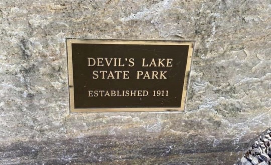

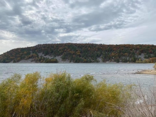
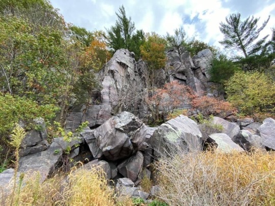
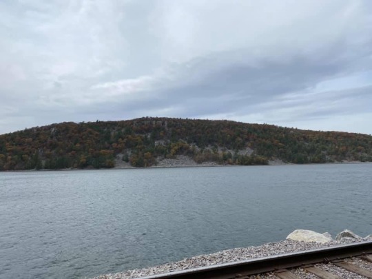
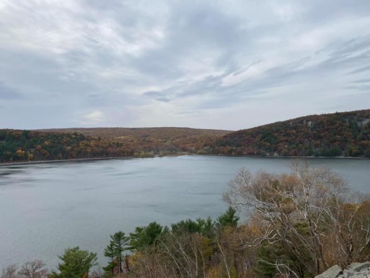
Devil’s Lake State Park (10/18/20)
#devils lake state park#wisconsin state parks#wisconsin nature preserves#wisconsin’s devil’s lake state park#wisconsin lakes#baraboo#wisconsin#baraboo wisconsin#sauk county#devils lake#east bluff trail of devils lake state park#wisconsin’s devils lake state park#east bluff trail#state parks and nature preserves of wisconsin#wisconsin wildlife#state parks#state parks & nature preserves of wisconsin#wisconsin beautiful nature preserves#wisconsin beautiful state parks#devil’s lake state park#wisconsin’s devil’s lake park#baraboo river#trees#bluff#nature#landscape
1 note
·
View note
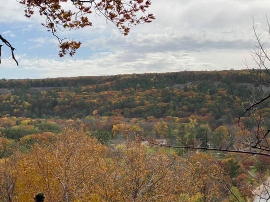
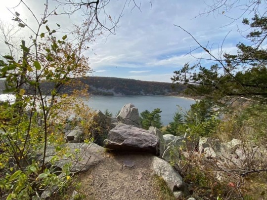
Text

East Bluff Trail at Devil’s Lake State Park, Wisconsin
27 notes
·
View notes
Text
Mel’s Big Fantasy Place-Name Reference
So I’ve been doing lots of D&D world-building lately and I’ve kind of been putting together lists of words to help inspire new fantasy place names. I figured I’d share. These are helpful for naming towns, regions, landforms, roads, shops, and they’re also probably useful for coming up with surnames. This is LONG. There’s plenty more under the cut including a huge list of “fantasy sounding” word-parts. Enjoy!
Towns & Kingdoms
town, borough, city, hamlet, parish, township, village, villa, domain
kingdom, empire, nation, country, county, city-state, state, province, dominion
Town Name End Words (English flavored)
-ton, -ston, -caster, -dale, -den, -field, -gate, -glen, -ham, -holm, -hurst, -bar, -boro, -by, -cross, -kirk, -meade, -moore, -ville, -wich, -bee, -burg, -cester, -don, -lea, -mer, -rose, -wall, -worth, -berg, -burgh, -chase, -ly, -lin, -mor, -mere, -pool. -port, -stead, -stow, -strath, -side, -way, -berry, -bury, -chester, -haven, -mar, -mont, -ton, -wick, -meet, -heim, -hold, -hall, -point
Buildings & Places
castle, fort, palace, fortress, garrison, lodge, estate, hold, stronghold, tower, watchtower, palace, spire, citadel, bastion, court, manor, house
altar, chapel, abbey, shrine, temple, monastery, cathedral, sanctum, crypt, catacomb, tomb
orchard, arbor, vineyard, farm, farmstead, shire, garden, ranch
plaza, district, quarter, market, courtyard, inn, stables, tavern, blacksmith, forge, mine, mill, quarry, gallows, apothecary, college, bakery, clothier, library, guild house, bath house, pleasure house, brothel, jail, prison, dungeon, cellar, basement, attic, sewer, cistern
lookout, post, tradepost, camp, outpost, hovel, hideaway, lair, nook, watch, roost, respite, retreat, hostel, holdout, redoubt, perch, refuge, haven, alcove, haunt, knell, enclave, station, caravan, exchange, conclave
port, bridge, ferry, harbor, landing, jetty, wharf, berth, footbridge, dam, beacon, lighthouse, marina, dockyard, shipyard
road, street, way, row, lane, trail, corner, crossing, gate, junction, waygate, end, wall, crossroads, barrier, bulwark, blockade, pavilion, avenue, promenade, alley, fork, route
Time & Direction
North, South, East, West, up, down, side, rise, fall, over, under
Winter, Spring, Summer, Autumn, solstice, equanox, vernal, ever, never
dusk, dawn, dawnrise, morning, night, nightfall, evening, sundown, sunbreak, sunset
lunar, solar, sun, moon, star, eclipse
Geographical Terms
Cave, cavern, cenote, precipice, crevasse, crater, maar, chasm, ravine, trench, rift, pit
Cliff, bluff, crag, scarp, outcrop, stack, tor, falls, run, eyrie, aerie
Hill, mountain, volcano, knoll, hillock, downs, barrow, plateau, mesa, butte, pike, peak, mount, summit, horn, knob, pass, ridge, terrace, gap, point, rise, rim, range, view, vista, canyon, hogback, ledge, stair, descent
Valley, gulch, gully, vale, dale, dell, glen, hollow, grotto, gorge, bottoms, basin, knoll, combe
Meadow, grassland, field, pasture, steppe, veld, sward, lea, mead, fell, moor, moorland, heath, croft, paddock, boondock, prairie, acre, strath, heights, mount, belt
Woodlands, woods, forest, bush, bower, arbor, grove, weald, timberland, thicket, bosk, copse, coppice, underbrush, hinterland, park, jungle, rainforest, wilds, frontier, outskirts
Desert, dunes, playa, arroyo, chaparral, karst, salt flats, salt pan, oasis, spring, seep, tar pit, hot springs, fissure, steam vent, geyser, waste, wasteland, badland, brushland, dustbowl, scrubland
Ocean, sea, lake, pond, spring, tarn, mere, sluice, pool, coast, gulf, bay
Lagoon, cay, key, reef, atoll, shoal, tideland, tide flat, swale, cove, sandspit, strand, beach
Snowdrift, snowbank, permafrost, floe, hoar, rime, tundra, fjord, glacier, iceberg
River, stream, creek, brook, tributary, watersmeet, headwater, ford, levee, delta, estuary, firth, strait, narrows, channel, eddy, inlet, rapids, mouth, falls
Wetland, marsh, bog, fen, moor, bayou, glade, swamp, banks, span, wash, march, shallows, mire, morass, quag, quagmire, everglade, slough, lowland, sump, reach
Island, isle, peninsula, isthmus, bight, headland, promontory, cape, pointe, cape
More under the cut including: Color words, Animal/Monster related words, Rocks/Metals/Gems list, Foliage, People groups/types, Weather/Environment/ Elemental words, Man-made Items, Body Parts, Mechanical sounding words, a huge list of both pleasant and unpleasant Atmospheric Descriptors, and a huge list of Fantasy Word-parts.
Color Descriptions
Warm: red, scarlet, crimson, rusty, cerise, carmine, cinnabar, orange, vermillion, ochre, peach, salmon, saffron, yellow, gold, lemon, amber, pink, magenta, maroon, brown, sepia, burgundy, beige, tan, fuchsia, taupe
Cool: green, beryl, jade, evergreen, chartreuse, olive, viridian, celadon, blue, azure, navy, cerulean, turquoise, teal, cyan, cobalt, periwinkle, beryl, purple, violet, indigo, mauve, plum
Neutral: gray, silver, ashy, charcoal, slate, white, pearly, alabaster, ivory, black, ebony, jet
dark, dusky, pale, bleached, blotchy, bold, dappled, lustrous, faded, drab, milky, mottled, opaque, pastel, stained, subtle, ruddy, waxen, tinted, tinged, painted
Animal / Monster-Related Words
Bear, eagle, wolf, serpent, hawk, horse, goat, sheep, bull, raven, crow, dog, stag, rat, boar, lion, hare, owl, crane, goose, swan, otter, frog, toad, moth, bee, wasp, beetle, spider, slug, snail, leech, dragonfly, fish, trout, salmon, bass, crab, shell, dolphin, whale, eel, cod, haddock
Dragon, goblin, giant, wyvern, ghast, siren, lich, hag, ogre, wyrm, kraken
Talon, scale, tusk, hoof, mane, horn, fur, feather, fang, wing, whisker, bristle, paw, tail, beak, claw, web, quill, paw, maw, pelt, haunch, gill, fin,
Hive, honey, nest, burrow, den, hole, wallow
Rocks / Metals / Minerals
Gold, silver, brass, bronze, copper, platinum, iron, steel, tin, mithril, electrum, adamantite, quicksilver, fool’s gold, titanium
Diamond, ruby, emerald, sapphire, topaz, opal, pearl, jade, jasper, onyx, citrine, aquamarine, turquoise, lapiz lazuli, amethyst, quartz, crystal, amber, jewel
Granite, shale, marble, limestone, sandstone, slate, diorite, basalt, rhyolite, obsidian, glass
Earth, stone, clay, sand, silt, salt, mote, lode, vein, ore, ingot, coal, boulder, bedrock, crust, rubble, pebble, gravel, cobble, dust, clod, peat, muck mud, slip, loam, dirt, grit, scree, shard, flint, stalactite/mite
Trees / Plants / Flowers
Tree, ash, aspen, pine, birch, alder, willow, dogwood, oak, maple, walnut, chestnut, cedar, mahogany, palm, beech, hickory, hemlock, cottonwood, hawthorn, sycamore, poplar, cypress, mangrove, elm, fir, spruce, yew
Branch, bough, bramble, gnarl, burr, tangle, thistle, briar, thorn, moss, bark, shrub, undergrowth, overgrowth, root, vine, bracken, reed, driftwood, coral, fern, berry, bamboo, nectar, petal, leaf, seed, clover, grass, grain, trunk, twig, canopy, cactus, weed, mushroom, fungus
Apple, olive, apricot, elderberry, coconut, sugar, rice, wheat, cotton, flax, barley, hops, onion, carrot, turnip, cabbage, squash, pumpkin, pepper
Flower, rose, lavender, lilac, jasmine, jonquil, marigold, carnelian, carnation, goldenrod, sage, wisteria, dahlia, nightshade, lily, daisy, daffodil, columbine, amaranth, crocus, buttercup, foxglove, iris, holly, hydrangea, orchid, snowdrop, hyacinth, tulip, yarrow, magnolia, honeysuckle, belladonna, lily pad, magnolia
People
Settler, Pilgrim, Pioneer, Merchant, Prospector, Maker, Surveyor, Mason, Overseer, Apprentice, Widow, Sailor, Miner, Blacksmith, Butcher, Baker, Brewer, Barkeep, Ferryman, Hangman, Gambler, Fisherman, Adventurer, Hero, Seeker, Hiker, Traveler, Crone
Mage, Magician, Summoner, Sorcerer, Wizard, Conjurer, Necromancer,
King, Queen, Lord, Count, Baron, Guard, Soldier, Knight, Vindicator, Merchant, Crusader, Imperator, Syndicate, Vanguard, Champion, Warden, Victor, Legionnaire, Master, Archer, Footman, Gladiator, Barbarian, Captain, Commodore,
Beggar, Hunter, Ranger, Deadman, Smuggler, Robber, Swindler, Rebel, Bootlegger, Outlaw, Pirate, Brigand, Ruffian, Highwayman, Cutpurse, Thief, Assassin
God, Goddess, Exarch, Angel, Devil, Demon, Cultist, Prophet, Hermit, Seer
council, clergy, guild, militia, choir
Climate, Environment, & The Elements
Cold, cool, brisk, frosty, chilly, icy, freezing, frozen, frigid, glacial, bitter, biting, bleak, arctic, polar, boreal, wintry, snowy, snow, blizzarding, blizzard, sleeting, sleet, chill, frost, ice, icebound, ice cap, floe, snowblind, frostbite, coldsnap, avalanche, snowflake
Hot, sunny, humid, sweltering, steaming, boiling, sizzling, blistering, scalding, smoking, caldescent, dry, parched, arid, fallow, thirsty, melting, molten, fiery, blazing, burning, charring, glowing, searing, scorching, blasted, sun, fire, heat, flame, wildfire, bonfire, inferno, coal, ash, cinder, ember, flare, pyre, tinder, kindling, aflame, alight, ablaze, lava, magma, slag,
Wet, damp, dank, soggy, sodden, soaked, drenched, dripping, sopping, briny, murky, rain, storm, hail, drizzle, sprinkle, downpour, deluge, squall, water, cloud, fog, mist, dew, puddle, pool, current, whirlpool, deep, depths, tide, waves, whitewater, waterfall, tidal wave, flow, flood, leak, drain
Wind, breeze, gust, billow, gail, draft, waft, zephyr, still, airy, clear, smokey, tempest, tempestuous, windswept, aerial, lofty, torrid, turbulent, nebulous, tradewind, thunder, lightning, spark, cyclone, tornado, whirlwind, hurricane, typhoon
Man-made Item Words
Furnace, forge, anvil, vault, strap, strip, whetstone, brick, sword, blade, axe, dagger, shield, buckler, morningstar, bow, quiver, arrow, polearm, flail, staff, stave, sheath, hilt, hammer, knife, helm, mantle, banner, pauldron, chainmail, mace, dart, cutlass, canon, needle, cowl, belt, buckle, bandana, goggles, hood, boot, heel, spindle, spool, thread, sweater, skirt, bonnet, apron, leather, hide, plate, tunic, vest, satin, silk, wool, velvet, lace, corset, stocking, binding
Plow, scythe, (wheel) barrow, saddle, harrow, brand, collar, whip, leash, lead, bridle, stirrup, wheel, straw, stall, barn, hay, bale, pitchfork, well, log, saw, lumber, sod, thatch, mortar, brick, cement, concrete, pitch, pillar, window, fountain, door, cage, spoke, pole, table, bench, plank, board
Candle, torch, cradle, broom, lamp, lantern, clock, bell, lock, hook, trunk, looking glass, spyglass, bottle, vase, locket, locker, key, handle, rope, knot, sack, pocket, pouch, manacle, chain, stake, coffin, fan. cauldron, kettle, pot, bowl, pestle, oven, ladle, spoon, font, wand, potion, elixir, draught, portal, book, tome, scroll, word, manuscript, letter, message, grimoire, map, ink, quill, pen, cards, dice
Coin, coronet, crown, circlet, scepter, treasure, riches, scales, pie, tart, loaf, biscuit, custard, caramel, pudding, porridge, stew, bread, tea, gravy, gristle, spice, lute, lyre, harp, drum, rouge, powder, perfume, brush
bilge, stern, pier, sail, anchor, mast, dock, deck, flag, ship, boat, canoe, barge, wagon, sled, carriage, buggy, cart
Wine, brandy, whiskey, ale, moonshine, gin, cider, rum, grog, beer, brew, goblet, flagon, flask, cask, tankard, stein, mug, barrel, stock, wort, malt
Body Parts
Head, throat, finger, foot, hand, neck, shoulder, rib, jaw, eye, lips, bosom
Skull, spine, bone, tooth, heart, blood, tears, gut, beard
Mechanical-Sounding Words
cog, fuse, sprocket, wrench, screw, nail, bolt, lever, pulley, spanner, gear, spring, shaft, switch, button, cast, pipe, plug, dial, meter, nozzle, cord, brake, gauge, coil, oil, signal, wire, fluke, staple, clamp, bolt, nut, bulb, patch, pump, cable, socket
torque, force, sonic, spark, fizzle, thermal, beam, laser, steam, buzz, mega, mecha, electro, telsa, power, flicker, charge, current, flow, tinker
Atmospheric Words
Unpleasant, Dangerous, Threatening
(nouns) death, fury, battle, scar, shadow, razor, nightmare, wrath, bone, splinter, peril, war, riptide, strife, reckoning, sorrow, terror, deadwood, nether, venom, grime, rage, void, conquest, pain, folly, revenge, horrid, mirk, shear, fathom, frenzy, corpselight/marshlight, reaper, gloom, doom, torment, torture, spite, grizzled, sludge, refuse, spore, carrion, fear, pyre, funeral, shade, beast, witch, grip, legion, downfall, ruin, plague, woe, bane, horde, acid, fell, grief, corpse, mildew, mold, miter, dirge
(adjectives) dead, jagged, decrepit, fallen, darkened, blackened, dire, grim, feral, wild, broken, desolate, mad, lost, under, stagnant, blistered, derelict, forlorn, unbound, sunken, fallow, shriveled, wayward, bleak, low, weathered, fungal, last, brittle, sleepy, -strewn, dusky, deserted, empty, barren, vacant, forsaken, bare, bereft, stranded, solitary, abandoned, discarded, forgotten, deep, abysmal, bottomless, buried, fathomless,unfathomable, diseased, plagued, virulent, noxious, venomous, toxic, fetid, revolting, putrid, rancid, foul, squalid, sullied, vile, blighted, vicious, ferocious, dangerous, savage, cavernous, vast, yawning, chasmal, echoing, dim, dingy, gloomy, inky, lurid, shaded, shadowy, somber, sunless, tenebrous, unlit, veiled, hellish, accursed, sulfurous, damned, infernal, condemned, doomed, wicked, sinister, dread, unending, spectral, ghostly, haunted, eldritch, unknown, weary, silent, hungry, cloven, acidic
(verb/adverbs): wither (withering / withered), skulk (skulking), whisper, skitter, chitter, sting, slither, writhe, gape, screech, scream, howl, lurk, roil, twist, shift, swarm, spawn, fester, bleed, howl, shudder, shrivel, devour, swirl, maul, trip, smother, weep, shatter, ruin, curse, ravage, hush, rot, drown, sunder, blister, warp, fracture, die, shroud, fall, surge, shiver, roar, thunder, smolder, break, silt, slide, lash, mourn, crush, wail, decay, crumble, erode, decline, reek, lament, taint, corrupt, defile, poison, infect, shun, sigh, sever, crawl, starve, grind, cut, wound, bruise, maim, stab, bludgeon, rust, mutilate, tremble, stumble, fumble, clank, clang
Pleasant, Safe, Neutral
(nouns) spirit, luck, soul, oracle, song, sky, smile, rune, obelisk, cloud, timber, valor, triumph, rest, dream, thrall, might, valiance, glory, mirror, life, hope, oath, serenity, sojourn, god, hearth, crown, throne, crest, guard, rise, ascent, circle, ring, twin, vigil, breath, new, whistle, grasp, snap, fringe, threshold, arch, cleft, bend, home, fruit, wilds, echo, moonlight, sunlight, starlight, splendor, vigilance, honor, memory, fortune, aurora, paradise, caress
(adjectives) gentle, pleasant, prosperous, peaceful, sweet, good, great, mild, grand, topic, lush, wild, abundant, verdant, sylvan, vital, florid, bosky, callow, verdurous, lucious, fertile, spellbound, captivating, mystical, hidden, arcane, clandestine, esoteric, covert, cryptic, runic, otherworldly, touched, still, fair, deep, quiet, bright, sheer, tranquil, ancient, light, far, -wrought, tidal, royal, shaded, swift, true, free, high, vibrant, pure, argent, hibernal, ascendant, halcyon, silken, bountiful, gilded, colossal, massive, stout, elder, -bourne, furrowed, happy, merry, -bound, loud, lit, silk, quiet, bright, luminous, shining, burnished, glossy, brilliant, lambent, lucent, lustrous, radiant, resplendent, vivid, vibrant, illuminated, silvery, limpid, sunlit, divine, sacred, holy, eternal, celestial, spiritual, almighty, anointed, consecrated, exalted, hallowed, sanctified, ambrosial, beatific, blissful, demure, naked, bare, ample, coy, deific, godly, omnipotent, omnipresent, rapturous, sacramental, sacrosanct, blessed, majestic, iridescent, glowing, overgrown, dense, hard, timeless, sly, scatter, everlasting, full, half, first, last
(verb/adverbs) arch (arching / arched), wink (winking), sing, nestle, graze, stroll, roll, flourish, bloom, bud, burgeon, live, dawn, hide, dawn, run, pray, wake, laugh, wake, glimmer, glitter, drift, sleep, tumble, bind, arch, blush, grin, glister, beam, meander, wind, widen, charm, bewitch, enthrall, entrance, enchant, allure, beguile, glitter, shimmer, sparkle twinkle, crest, quiver, slumber, herald, shelter, leap, click, climb, scuttle, dig, barter, chant, hum, chime, kiss, flirt, tempt, tease, play, seduce
Generic “Fantasy-Sounding” Word Parts
A - D
aaz, ada, adaer, adal, adar, adbar, adir, ae, ael, aer, aern, aeron, aeryeon, agar, agis, aglar, agron, ahar, akan, akyl, al, alam, alan, alaor, ald, alea, ali, alir, allyn, alm, alon, alor, altar, altum, aluar, alys, amar, amaz, ame, ammen, amir, amol, amn, amus, anar, andor, ang, ankh, ar, ara, aram, arc, arg, arian, arkh, arla, arlith, arn, arond, arthus, arum, arvien, ary, asha, ashyr, ask, assur, aster, astra, ath, athor, athra, athryn, atol, au, auga, aum, auroch, aven, az, azar, baal, bae, bael, bak, bal, balor, ban, bar, bara, barr, batol, batar, basir, basha, batyr, bel, belph, belu, ben, beo, bere, berren, berun, besil, bezan, bhaer, bhal, blask, blis, blod, bor, boraz, bos, bran, brath, braun, breon, bri, bry, bul, bur, byl, caer, cal, calan, cara, cassa, cath, cela, cen, cenar, cerul, chalar, cham, chion, cimar, clo, coram, corel, corman, crim, crom, daar, dach, dae, dago, dagol, dahar, dala, dalar, dalin, dam, danas, daneth, dannar, dar, darian, darath, darm, darma, darro, das, dasa, dasha, dath, del, delia, delimm, dellyn, delmar, delo, den, dess, dever, dhaer, dhas, dhaz, dhed, dhin, din, dine, diar, dien, div, djer, dlyn, dol, dolan, doon, dora, doril, doun, dral, dranor, drasil, dren, drian, drien, drin, drov, druar, drud, duald, duatha, duir, dul, dulth, dun, durth, dyra, dyver,
E - H
ea, eber, eden, edluk, egan, eiel, eilean, ejen, elath, eld, eldor, eldra, elith emar, ellesar, eltar, eltaran, elth, eltur, elyth, emen, empra, emril, emvor, ena, endra, enthor, erad, erai, ere, eriel, erith, erl, eron, erre, eryn, esk, esmel, espar, estria, eta, ethel, eval, ezro, ezan, ezune, ezil, fael, faelar, faern, falk, falak, farak, faril, farla, fel, fen, fenris, fer, fet, fin, finar, forel, folgun, ful, fulk, fur, fyra, fallon, gael, gach, gabir, gadath, gal, galar, gana, gar, garth, garon, garok, garne, gath, geir, gelden, geren, geron, ghal, ghallar, ghast, ghel, ghom, ghon, gith, glae, glander, glar, glym, gol, goll, gollo, goloth, gorot, gost, goth, graeve, gran, grimm, grist, grom, grosh, grun, grym, gual, guil, guir, gulth, gulur, gur, gurnth, gwaer, haa, hael, haer, hadar, hadel, hakla, hala, hald, halana, halid, hallar, halon, halrua, halus, halvan, hamar, hanar, hanyl, haor, hara, haren, haresk, harmun, harrokh, harrow, haspur, haza, hazuth, heber, hela, helve, hem, hen, herath, hesper, heth, hethar, hind, hisari, hjaa, hlath, hlond, hluth, hoarth, holtar, horo, hotun, hrag, hrakh, hroth, hull, hyak, hyrza
I - M
iibra, ilth, ilus, ilira, iman, imar, imas, imb, imir, immer, immil, imne, impil, ingdal, innar, ir, iriae, iril, irith, irk, irul, isha, istis, isil, itala, ith, ithal, itka, jada, jae, jaeda, jahaka, jala, jarra, jaro, jath, jenda, jhaamm, jhothm, jinn, jinth, jyn, kado, kah, kal, kalif, kam, kana, kara, karg, kars, karth, kasp, katla, kaul, kazar, kazr, kela, kelem, kerym, keth, keva, kez, kezan, khaer, khal, khama, khaz, khara, khed, khel, khol, khur, kil, kor, korvan, koll, kos, kir, kra, kul, kulda, kund, kyne, lae, laen, lag, lan, lann, lanar, lantar, lapal, lar, laran, lareth, lark, lath, lauth, lav, lavur, lazar, leih, leshyr, leth, lhaza, lhuven, liad, liam, liard, lim, lin, lirn, lisk, listra, lith, liya, llair, llor, lok, lolth, loran, lorkh, lorn, loth, lothen, luen, luir, luk, lund, lur, luth, lyndus, lyra, lyth, maal, madrasm maera, maer, maerim, maes, mag, magra, mahand, mal, malar, mald, maldo, mar, mara, mark, marl, maru, maruk, meir, melish, memnon, mer, metar, methi, mhil, mina, mir, miram, mirk, mista, mith, moander, mok, modir, modan, mon, monn, mor, more, morel, moril, morn, moro, morrow, morth, mort, morum, morven, muar, mul, mydra, myr, myra, myst
N - S
naar, nadyra, naedyr, naga, najar, nal, naal, nalir, nar, naruk, narbond, narlith, narzul, nasaq, nashkel, natar, nath, natha, neir, neth, nether, nhall, nikh, nil, nilith, noan, nolvurm nonthal, norda, noro, novul, nul, nur, nus, nyan, nyth, ober, odra, oghr, okoth, olleth, olodel, omgar, ondath, onthril, ordul, orish, oroch, orgra, orlim, ormath, ornar, orntath, oroch, orth, orva, oryn, orzo, ostel, ostor, ostrav, othea, ovar, ozod, ozul, palan, palad, pae, peldan, pern, perris, perim, pele, pen, phail, phanda, phara, phen, phendra, pila, pinn, pora, puril, pur, pyra, qadim, quar, quel, ques, quil, raah, rael, ran, ranna, rassil, rak, rald, rassa, reddan, reith, relur, ren, rendril, resil, reska, reth, reven, revar, rhy, rhynn, ria, rian, rin, ris, rissian, rona, roch, rorn, rora, rotha, rual, ruar, ruhal, ruil, ruk, runn, rusk, ryn, saa, saar, saal, sabal, samar, samrin, sankh, sar, sarg, sarguth, sarin, sarlan, sel, seld, sember, semkh, sen, sendrin, septa, senta, seros, shaar, shad, shadra, shae, shaen, shaera, shak, shalan, sham, shamath, shan, shana, sharan, shayl, shemar, shere, shor, shul, shyll, shyr, sidur, sil, silvan, sim, sintar, sirem, skar, skell, skur, skyr, sokol, solan, sola, somra, sor, ssin, stel, strill, suldan, sulk, sunda, sur, surkh, suth, syl, sylph, sylune, syndra, syth
T - Z
taak, taar, taer, tah, tak, tala, talag, talar, talas, talath, tammar, tanar, tanil, tar, tara, taran, tarl, tarn, tasha, tath, tavil, telar, teld, telf, telos, tempe, tethy, tezir, thaar, thaer, thal, thalag, thalas, thalan, thalar, thamor, thander, thangol, thar, thay, thazal, theer, theim, thelon, thera, thendi, theril, thiir, thil, thild, thimir, thommar, thon, thoon, thor, thran, thrann, threl, thril, thrul, thryn, thuk, thultan, thume, thun, thy, thyn, thyr, tir, tiras, tirum, tohre, tol, tolar, tolir, tolzrin, tor, tormel, tormir, traal, triel, trith, tsath, tsur, tul, tur, turiver, turth, tymor, tyr, uder, udar, ugoth, uhr, ukh, ukir, uker, usten, ulgarth, ulgoth, ultir, ulur, umar, umath, umber, unara, undro, undu, untha, upir, ur, ursa, ursol, uron, uth, uthen, uz, van, vaar, vaelan, vaer, vaern, val valan, valash, vali, valt, vandan, vanede, vanrak, var, varyth, vassa, vastar, vaunt, vay, vel, velar, velen, velius, vell, velta, ven, veren, vern, vesper, vilar, vilhon, vintor, vir, vira, virdin, volo, volun, von, voon, vor, voro, vos, vosir, vosal, vund, war, wara, whel, wol, wynn, wyr, wyrm, xer, xul, xen, xian, yad, yag, yal, yar, yath, yeon, yhal, yir, yirar, yuir, yul, yur, zail, zala, zalhar, zan, zanda, zar, zalar, zarach, zaru, zash, zashu, zemur, zhent, zim, ziram, zindala, zindar, zoun, zul, zurr, zuth, zuu, zym
A lot of places are named after historical events, battles, and people, so keep that in mind. God/Goddess names tied to your world also work well. Places are also often named after things that the area is known for, like Georgia being known for its peaches.
My brain was fried by the end of this so feel free to add more!
I hope you find this reference helpful and good luck world-building!
-Mel
10K notes
·
View notes
Text
Friday, July 9 - Sunday, July 11, 2021
Happy to be back out on the Ice Age Trail!! We’re hiking without Gary as he had to fly back to New Jersey for a funeral today, but with luck will see him tomorrow. Our rendezvous point was only 70 minutes from our house so it was nice to be able to leave just after 6 AM and get to the meeting point before 7:30 AM. Even though we’d just seen everyone, we were excited to be together again. Jeff had to gently shepherd us into the cars, reminding us that we had all day to talk and swap stories and we should get going.
We left two cars at our meeting point and got into Dan and Tam‘s SUV and drove to the start of the Deerwood Segment, where we left off on that rainy Sunday just a few weeks ago. We were delighted to find it looking much different today - it’s a perfect Wisconsin summer day. It was about 60° when we started out, with plenty of sunshine.
We hiked 10 miles before a lunch break - wonderful segments (Deerfield, Bohn Lake and Greenwood) through pine trees, around beautiful lakes, with short road walks mixed in. This combination allows us to cover pretty good ground because we can really book it on the road walk and stop and enjoy when we’re in the woods a little bit more. We took two different snack breaks this morning which was really helpful because I was used to having a long drive to drink my coffee and gradually eat my breakfast. I brought along my small thermos of coffee and that was really great to wash down a cliff bar with hot coffee. Another unusual factor is that we encountered several couples – still so strange to see others on these amazing trails. One couple was out with their 11-year-old dog, and said they walk this 4-mile loop every day. The other couple had three grandchildren along and they had buckets and were just going blackberry picking. We chatted with them for a while and Tam told the kids to pick enough berries so grandma could make a blackberry cobbler. Grandma said “shut up,” which gave us all a great laugh and reminded us of Jen at the bar a couple weeks ago who told a customer “Shut up and give me all your money.” In addition to a couple snack breaks I ate a lot of ripe blackberries along the trail (yum) and found myself hoping that the café at lunchtime will have blackberry cobbler.
The summer wildflowers are really starting to come in to full bloom which attracts a myriad of different kind of butterflies, including many monarchs. As we were walking through the pine forest, it was very quiet due to the sand and pine needles underfoot and we heard buzzing in the trees. While we couldn’t see a beehive, we’re pretty sure that’s what we heard. We walked probably another hundred feet and had the same thing. It was really cool and it made me think made me think of Winnie the Pooh and the way he would sing to the honeybees and try to float along with a balloon to get the honey from the hive in the tree!
After 10 miles we came out through the woods right where our cars were – always, thankful for that! We climbed into the two cars and drove about 7 miles to Coloma where we stopped at the Red Hill café for lunch (except we all had omelets). This is an Amish area and the café served an Amish wheat bread with our omelets, the best bread I’ve had in a long time! One of their specials of the day was a ‘double caramel chocolate roll muffin’ which sounded a bit too decadent, even for me. Like all establishments these days the café was probably short-staffed so it took a long time for us to order and for our food to come, so it was about 2:30p before we shuttled the cars and were back on the trail. With full bellies, it was off to a slow start as we started again down the connecting road.
This afternoon we finished the Greenwood segment had a short road walk and started the Mecan River segment. The area was designated Mecan Springs State Natural Area, and the trail was gorgeous but we didn’t see much of the river, which is always disappointing to me.
We all had several wood-ticks today, but we’re getting used to them and no one seems as freaked out as last year. Other than a few flies, and some intermittent buzz-bys from deer flies, no other bugs – no mosquitoes, which is a bit unbelievable!
At one point the trail today came out into a farm field and there was a fabulous prairie easement between two cornfields and that we were allowed to walk through. We rousted up some sand hill cranes, always majestic to watch them take off and fly away. The prairie flowers were just starting to come into bloom and the view was breathtaking to me. There were spots in the cornfield where the probably original oak trees still stood and rocks were piled up and you could just imagine the settlers clearing the fields and piling up the rocks. And we think we’re working hard out here just slogging along the trail, silly us!
With our dallying, it was nearly 6 o’clock before we got back to the car – 17.5 miles for the day. We had a quick shuttle to pick up the other two cars and soon we were back in Coloma for a bathroom stop at the gas station. Jeff and I picked up root beer floats at the A&W that was attached to the gas station. The other two couples stopped at a restaurant in Coloma for dinner, but Jeff and I decided to head home and tend to our cat. We arrived home about 7:30 PM completely exhausted. I had all I could do to eat a little leftover salad, re-supply my pack for tomorrow run a hot bubble bath and then crawl into bed shortly after nine.
A late-night text from Gary said he was stranded in Charlotte, North Carolina which is pretty far from New Jersey, and further from Wisconsin. On our drive north today, we learned he was now in Detroit, which is closer, but he still wasn’t going to make the hike today. That made us all sad because we’re a little lost without him, but we pressed on anyway. We were all at the rendezvous spot at 8 AM, and we took two cars back to Highway GG in the middle of the Mecan river segment and we were hiking by 8:30 AM, an easy early start.
This part of the Mecon river segment actually paralleled the river, winding around through oak and pine forest, on another absolutely gorgeous Wisconsin summer day. The ladies lagged behind a bit, using my “Picture This” app to identify some of the flowers. We were hiking through an area that had been logged several years before, which was now growing a bunch of pretty flowers and berries most of which are poisonous to humans of course.
Over the past two days, much of the trail had vole or moles that had burrowed trails than intersected under our trails! We were a bit perplexed by the volume, but actually, it made for softer trails. Jeff figured there must be a lot of grubs in the area for them to be eating!
We had a great morning enjoying the hike along the river, stopping once at a bench to take a coffee break and enjoy the scenery. We ended the Mecan River segment and had 2.3-mile road walk. It was warm but we had a nice breeze. We walked through a little village, Richford, which seemed to be primarily an Amish settlement. We walked through the edge of a cemetery with really old tombstones -many of them that you couldn’t even make out the writing anymore. I heard a “clap clap clap” on the pavement behind us, and there was an Amish farmer in a horse and buggy – that was a first for our connecting route walking! Soon we heard another, but that one was a horse pulling a farmer in a really uncomfortable looking cart!
We arrived at the start of Wedde Creek segment, and took another sit-down break – most of us taking off our boots to cool our feet after walking on the hot road. It was a shorter segment, through another gorgeous pine forest and a meadow with lots of wildflowers and butterflies. I lagged behind the group taking photos and just embracing the joy of the day.
After that we had 0.7-mile CR to the Chaffee Creek Segment which will be our last segment for about 40 miles. On this segment we crossed underneath Highway 51 again (we crossed from west to east just south the Tomahawk sometime last winter). For the next couple days will cross underneath Highway 51 back-and-forth a few times until we get to Portage and then will finally turn west and get into familiar territory for us.
We backtracked about a half mile to visit the Rest Stop on I-39/51 – kind of crazy, but always great to have a flush toilet! We hiked through the last of the Chaffee Creek segment, crossing the creek again. We went through another pretty meadow with lots of butterfly activity. We ended up at an official trail parking at a cul de sac, and chatted with a guy there that appeared he was going to do trail maintenance, but actually was doing some work on a friend’s adjacent property. There was trash there that indicated the cul de sac may be a party site. I had a trash bag in my pack, so I pulled it out and started cleaning up the space. Down the road just a bit, there was a branch of a tree nearly blocking the road – the guys got out Jeff’s saw and cleared the road – probably the first time in nearly 600 miles that they cleared a tree on a connecting route!
We had about 1.5 miles CR to get back to Kent’s SUV. We picked up enough trash to fill up TWO bags on our way, always feels good to leave it a little better than we found it. Just don’t get what’s in people’s minds that they just throw trash out the window.
Felt great to be down early. We shuttled back to the Mecan River segment to pick up the other two SUVs, and then to the gas station / A&W in Coloma again. We were home just about 4pm, which was awesome.
For reasons that I don’t understand the Ice Age Trail has a bifurcation, and at the end of our day today we reached that spot of the northern bifurcation. We have opted to take the eastern route which will lead us to Portage, where we’ll walk Levee Road on the south side of the Wisconsin River, south over the Baraboo Bluffs, and we’ll pick up a trail again just around Parfrey’s Glen and that will take us to Devils Lake. The western bifurcation like the eastern in that its mostly CR with very few trail segments. It goes through Baraboo and rejoins the trail at the north side of Devils Lake.
Throughout the hike, we’ve had a lot of Kilimanjaro logistics chatter – its both exciting and anxiety provoking, but I’m so looking forward to that trek – just 9 weeks out now.
Sunday morning, we met at 8AM in Westfield. Shocking to arrive 20 minutes early and find the Knickmeier’s’ already there!! And no Gary, but soon after we arrived, Kent and Lynn pulled in, and Gary soon behind him. Definitely a first! We were all glad to have him back with us today. We left 3 cars in the parking lot of the “Bent Rail” brewpub, where we planned to have lunch. We shuttled north to where we’d left off yesterday, another gorgeous day. I figured we had about 10 miles to lunch, and we were hiking by 8:15am. Even though it was all CR, I managed to pick up a wood-tick during my “quick trip” stop in the woods before we started!
We walked through a lake/resort area, which was odd after days of farms. There were people out running and road cyclists out enjoying the morning – felt kind of normal to us, but different from what we’ve been seeing.
Time passed quickly; seems we never really run out of things to talk about since we’re such a companiable group! It’s also ok for someone to be out front alone when they want to move, or lag behind when they want space. We took a few snack breaks, but mainly just moved. True to form, I was a bit off in the math using the Guthook app to estimate the distance, and it was actually 12 miles. It was warm, but generally with a nice breeze and we arrived at the brew pub about 12:30pm. Like everywhere, they were short staffed – in fact, had a note on their menu asking for patience and offering rewards of free beer for employee referrals. We had a delightful waitress named Tanya, and had some great beer and good food. Patience was required though, and it was after 2P before we were back on the road. Gary and I shuttled his SUV just 3 more miles down the road, and we set off hiking about 2:30PM, and knocked it out in about an hour. Half of it was on a busy County Highway J, so it was great to turn off onto a smaller road, past a few farms and to Gary’s car.
We volunteered to bring Tam and Dan back to their car, which gave us an opportunity to detour back to Coloma and get another A&W float for the drive home. Made for a perfect day! We got a text from Lynn that I-94 had a backup, so we diverted to Portage and took a slower more leisurely
0 notes
Text
Top Hikes on the North Shore

Gooseberry Falls Hike, Two Harbors
Take the one-mile handicap accessible hike in Gooseberry State Park to the iconic main falls. These falls were recently voted as the best fall hiking trails in Minnesota. Hikers will find smaller crowds in the morning or late afternoon hours. To reach the state park, follow Highway 61 northeast for 13 miles.
Split Rock River Loop, Two Harbors
What makes this loop noteworthy is its unique red rhyolite rock towers near the boundary of the park, the beautiful overlook of Lake Superior and the river valley on the east side of the trail. While you’re hiking, keep an eye out for a peregrine falcon. Split Rock lighthouse is home to aeries of this once almost eradicated bird. Access the trail from Highway 61 northeast of Two Harbors at mile 43.5. Park on the left side of the highway.
Twin Lakes (Bean and Bear) Loop, Silver Bay
This challenging loop trail goes up and down three maple-covered ridges where hikers will find spectacular views of Bean and Bear Lakes at the top. It can be accessed from two locations: from the Penn Boulevard trailhead outside of Silver Bay for a 6.8-mile hike or from the Silver Bay visitor Center located on Outer Drive for a 7.6-mile hike. Both will bring you to the Twin Lakes Loop.
High falls to Two Step Falls, Silver Bay
View the 60-foot High Falls and Two Step Falls of the Baptism River on a difficult two-mile round-trip hike through Tettegouche State Park. Start at the trailhead in the park where the path will lead you to various overlooks of the High Falls, including one from a suspension bridge. Trails also give hikers the option to reach the base for a unique view of the falls. From the High Falls, hikers can continue their hike to the Two-Step Falls. As its name suggests, the fall has two drops. Both split and fall into a pool below.
Shovel Point, Silver Bay
Take the half-mile trail from the Tettegouche visitor center along Shovel Point to see many breathtaking views of the lake-side cliffs, sea caves, inland bluffs, and the mouth of the Baptism River. Once hikers reach the end of the out-and-back trail, they will see views of Lake Superior’s seemly endless shoreline that will leave them awestruck.
Temperance River Falls Hike, Schroeder
Hikers can see many beautiful waterfalls, pools, gorges and river potholes by hiking north of Highway 61 from the parking area along Highway 61. Hike as far as you like up the trail for views of the Temperance River cascades.
Beautiful fall colors on the Oberg Loop. Lutsen, Minnesota.[/caption]
Oberg Mountain Loop, Tofte
The Oberg Mountain Loop is one of the most popular hikes on the North Shore, and rightly so! The two-mile loop circles the top of the mountain and brings hikers to a number of lookouts with spectacular views of Leveaux Mountain, Moose Mountain, Oberg Lake, and the Lake Superior Shoreline. Hike the loop counterclockwise for increasingly dramatic views. To access the trail, drive to the trailhead parking lot two miles north of Highway 61 on the Onion River Road.
White Sky Rock
Take the short but challenging one-third-mile hike from Caribou Trail to see a spectacular view of Caribou Lake and the surrounding Sawtooth Mountains. If you’re feeling adventurous, continue on the Superior Hiking Trail west to pristine Lake Agnes. There’s something about the shape of the lake and the beautiful overlooks that make this one of our favorite hikes any time of the year. To get there from Lutsen, take the Caribou Trail north for 3.9 miles. Park in the parking lot located on the right-hand side of the road near the boat ramp. After parking, cross Caribou Trail and begin the hike up the Superior Hiking Trail spur trail to White Sky Rock.
Eagle Mountain,
The out-and-back trek up Eagle Mountain, Minnesota’s highest peak, is difficult, but worth it! The hike is seven miles round-trip and will bring you to places with spectacular views. The hike will take you past Whale Lake which is located halfway along the trail. From the peak, you’ll also be able to view Lake Superior. Since two-thirds of the trail lies within the Boundary Waters Canoe Area, you’ll need to get a self-issued permit at the entry point before you begin hiking.
From Lutsen drive east (toward Grand Marais) and take a left onto Caribou Trail (County Road 4). Follow Caribou Trail until it ends. Turn right onto FR170. Drive 3.5 miles to the Eagle Mountain Trailhead. Park in the parking lot on the left-hand side of the road.
Honeymoon Bluff, Gunflint Trail
This short half-mile trail takes hikers 200 feet above the beautiful Hungry Jack Lake. Since it is so short and the view is so great, hikers may feel like they’re cheating. Begin the hike on Clearwater Road (County Road 66). To get there from Grand Marais, take the Gunflint Trail for 27 miles and turn right onto Clearwater Road (County Road 66). Drive 3.25 miles.
Devil Track River Hike, Grand Marais/Gunflint Trail|
This trail is known for its red cliffs and waterfalls. To access the trail, drive four miles east of Grand Marais on Highway 61 and turn left onto Lindskog Road. Drive one mile to the trail.
Devil’s Kettle Hike
Hike along the Brule River in Judge C.R. Magney State Park to view the Upper, Devils Kettle and Lower Falls. Devils Kettle Falls is the most well-known of these three falls. The falls split in two with one side heading downstream and the other into a deep mysterious hole. No one knows where the water in this hole disappears. The hike to the falls is moderate in difficulty and requires hikers to ascend/descend 200 stairs. Begin at the state park’s main parking lot.
Grand Portage High Falls Hike, Grand Portage
Take this easy one-and-half mile trail and boardwalk in Grand Portage State Park to Minnesota’s highest waterfall. The 120-foot falls of the Pigeon River is known by many as Minnesota’s Niagra Falls.
Cascade Vacation Rentals offers the largest selection of vacation rental homes, cabins, hotels and cottages on the North Shore of Lake Superior. Our rentals cover a large area from Duluth to Grand Portage and inland up the Caribou Trail, Gunflint Trail and throughout Cook County. View rentals by location (Duluth, Two Harbors, Schroeder, Tofte, Lutsen, Grand Marais, Gunflint Trail) or category type (pet-friendly, large homes, inland lake homes, etc) at www.cascadevacationrentals.com.
Check back often for updates on where to go and the top things to do on your next North Shore visit.
#hiking#north shore#backpacking#national park#visitcookcounty#road trip#mountain biking#fall colors#vacation#vacation rentals
0 notes
Text
Hiking and Trails in Menomonie , WI

The Red Cedar State Trail and Hoffman Hills Recreation Area as well as Menomin Park, a large rustic park located on the east side of Lake Menomonie offers picnic tables, picnic shelters and abundant opportunities to walk and hike, with frequent deer and eagle sightings.
Nature Attractions / Caves / Hills & Devil’s Punchbowls
Crystal Cave is fun for the entire family! Discover the wonders of Crystal Cave with professionally guided tours. Explore passages descending more than 70 feet below the earth! Search for real gems and fossils at Prospector’s Creek, hike our nature trails, and enjoy our educational gift shop. There’s always something new to discover and explore at Wisconsin’s longest cave! You are guaranteed an adventure truly under this world!
Crystal Cave is located at W965 State Road 29 in Spring Valley, Wisconsin.Web: www.acoolcave.com Phone: (715) 778-4414
For thousands of years the underground springs, melting snow and rain have percolated their way through the sandstone bluffs seeking the Red Cedar River. On a sunny day, the light illuminates the small natural canyon that locals long ago named the Devil’s Punch Bowl. The area is now protected, due to its delicate eco-environment. The Punch Bowl is located on Paradise Valley Road (410th St.), also Rustic Road #89. Parking is available for those interested in viewing the park.
Hoffman Hills Recreation Area is located northeast of Menomonie. The popular recreation area has over nine miles of hiking and cross-country ski trails of varying difficulty. The 705-acre park features 15 acres of prairie restoration, a one-mile wetland trail and a 60-foot observation tower–one of the highest points in Dunn County. During the winter, trails are groomed for cross-country skiing (traditional-stride and skate-skiing) and there is a two-mile groomed trail for snowshoeing.
Although there is no admission fee to Hoffman Hills, trail passes are required for all skiers 16 years and older. Youth group camping is available. Call the Department of Natural Resources at (715) 232-1242 to make reservations.
The Stokke Trail begins on the north side of Highway 29 at the Menomonie trailhead of the Red Cedar State Trail, near Riverside Park. This asphalt surfaced walking and biking trail proceeds north along the Red Cedar River about a mile to State Highway 25. Convenient parking and benches make this trail one of the easy-access treasures of the area to be shared with blue heron, bald eagles and white-tailed deer. No trail pass is required. This trail connects to the Junction Trail, an asphalt walking and biking trail that follows the old railroad bed through North Menomonie.
0 notes
Text
Top 5 Hikes In Wisconsin
Wisconsin is a midwestern US state known for its 2 Great Lakes and fertile land covered in forests and farms. Its largest city, Milwaukee, is home to the largest of their attractions including the Milwaukee Public Museum, international villages, and Harley-Davidson Museum. But, if you look to nature, you’ll find Wisconsin’s most beautiful attractions: long, rich, beautiful trails covering the state from corner to corner. Here are 5 Wisconsin trails you are sure to love.
Best Hiking Trails In Wisconsin
Rank Trail Length (miles) 1 Devil’s Lake Loop 4.8 2 Parfrey’s Glen Trail 1.7 3 Gander Mountain Loop Trail 1.0 4 Ice Age Trail To Lapham Peak 2.8 5 Glacial Pothole And Ice Age Trail 1.8
1. Devil’s Lake Loop
Location: GPS 43.152691, -89.283013
Mileage: 4.8 miles
Hike Time: 4-5 hours
Devil’s Lake Trail is a 4.8-mile loop trail in Baraboo, Wisconsin. It’s a moderately trafficked moderately difficult trail open from July to November with an overall elevation gain of 813 feet. Here, you may go dog walking, camping, fishing, birding, mountain biking, hiking, on nature trips, trail running, paddling and walking. You’ll see a forest, lake, beach, amazing views, wild flowers, and plenty of wildlife.
Devil’s Lake loop trail starts out on the pavement and looks flat and easy until you follow further along, and before you know it, you’re headed up a steep climb (some may need to use hiking poles or walking poles) until you’re out of breath and looking over Devil’s Lake. Follow the trail and you’ll come across a parking lot with state park buildings, bathrooms, picnic areas, and beach areas. If you continue to the East, you’ll find another long and steep climb with some fantastic lake views and neat rock formations.
There’s something here for everyone. If you want to go swimming or simply want a workout, visit Devil’s Lake Loop.
2. Parfrey’s Glen Trail
Location: GPS 43.419206, -89.641666
Mileage: 1.7 miles
Hike Time: 1-2 hours
Parfrey’s Glen Trail is a 1.7 mile out and back trail in Merrimac, Wisconsin. It’s a moderately trafficked easy trail open year-round with an overall elevation gain of 236 feet. Here, you may go birding, snowshoeing, hiking, on nature trips, trail running, and walking. You’ll see a forest, waterfall, river, and historic sites. The path itself is very muddy and rocky.
Parfrey’s Glen is the first Natural area in the state of Wisconsin and is the most visited natural area in the state. It’s generally open from 6am to 8pm. At the heights of the park, you’ll find a mountain-type stream with a depth of almost 100 feet.
Over the last 20 years, the land has been modified with powerful floods. With that, the glen has undergone closures, repairs, and upgrades with new bridges. Old bridges once traveled in the 80s and 90s no longer exist, and the trail was completely repaired. Those who wish to see the waterfall have to get through the stream and rough stone. Steps to the old viewing area are damaged, and the viewing area has collapsed. Regardless, it’s a place of natural history you shouldn’t miss.
3. Gander Mountain Loop Trail
Location: GPS 42/.493269, -88.198962
Mileage: 1.0 miles
Hike Time: 1-2 hours
Gander Mountain Loop Trail is a 1.0-mile loop trail in Wilmot, Wisconsin. It’s a moderately trafficked difficult trail open year-round with an overall elevation gain of 203 feet. Here, you may go dog walking, cross-country skiing, birding, horseback riding, mountain biking, skiing, snowshoeing, hiking, on nature trips, trail running, and walking. You’ll see a forest, river, wildlife, and plenty of bugs. The path itself is muddy and rocky.
Gander Mountain Lake County is home to a preserved forest of 3.0-5.0 miles of land. It’s most popular for mountain biking and birding. It has some rugged topography and is very scenic. It’s not developed which allows you natural Wisconsin in its finest state. If you’re looking for an immersive wilderness experience, you should try hiking on the Gander Mountain Loop Trail.
4. Ice Age Trail To Lapham Peak
Location: GPS 43.040201, -88.401434
Mileage: 2.8 miles
Hike Time: 1-2 hours
Ice Age Trail to Lapham Peak is a 2.8-mile loop trail in Delafield, Wisconsin. It’s a moderately trafficked moderately difficult trail open year-round with an overall elevation gain of 377 feet. Here, you may go camping, snowshoeing, hiking, on nature trips, trail running and walking as you would in many US national parks. You’ll see a forest and lake.
The Ice Age Trail is one small part of a network of trails covering more than 1,000 miles of land. It’s a National Scenic Trail almost exclusively in Wisconsin. It follows the last continental glacier in the state.
This trail offers you top hiking experience and is revered by hiking enthusiasts who enjoy a scenic and silent hike. It takes you through some of Wisconsin’s most beautiful areas and shares with you the story of the last Ice Age. Along the trail, you may access hundreds of trailheads and access points along with other trails.
5. Glacial Pothole And Ice Age Trail
Location: GPS 43.040524, -88.399351
Mileage: 1.8 miles
Hike Time: 2-3 hours
Glacial Pothole and Ice Age Trail is a 1.8-mile loop trail in St. Croix Falls, Wisconsin. It’s a heavily trafficked easy trail open year-round with an overall elevation gain of 133 feet. Here, you may go birding, hiking, on nature trips, trail running, rock climbing, and walking. You’ll see a river, wild flowers, and very nice views.
In keeping with the Ice Age Trail, this is another part of the trail system with moderate hiking trails and lots of nice rock climbing spots if you bring carabiners. It has some trails connected to it that will take you to the Interstate State park camp ground.
On the trail, you’ll find yourself taking in some amazing views of the St. Croix river from high elevations and overlooks. The trail is well marked with little flat ground. The rock climbing is fantastic with nice bluffs to look over. If you enjoy heights, you’re going to love Glacial Pothole and Ice Age Trail.
For those of you who enjoy natural history and the quiet beauty Wisconsin has to offer, you’re sure to love these five trails. They’re short and sweet with rugged terrain to challenge the most experienced of hikers. Get on your hiking boots and prepare for a hike deep into the Wisconsin outback.
The post Top 5 Hikes In Wisconsin appeared first on Montem Outdoor Gear.
from Montem Outdoor Gear https://montemlife.com/top-5-hikes-in-wisconsin/
0 notes
Text
I feel like I am in the process of a recovery of some kind.
While this summer has been really stressful so far, I have come to some realizations. One of them was that my entire method of storytelling has changed, and somewhere along the line I stopped telling stories. I have been too wrapped up in strategy, and that is largely because I work on social marketing all day. Posting a photo of my life is quick and easy to do in the moment, but somehow all my actual stories have been condensed down into photos and attempts at witty commentary on whatever’s going on in my life. I MISS telling my stories. Case in point:
#nofilter #nature #Forest #NatureIsMyChurch #Heathen #DevilOrSpirit #SpiritLake
A post shared by Mary Diamond (@revolutionmary) on Jun 23, 2018 at 3:52pm PDT
Back in the day, yada yada, I used to write far too many words. Honestly, I think I may be coming full circle – because I need to bring back storytelling the way I used to do it, back when I wrote because I wanted to. So all strategy aside – I’m going to tell the story of a recent weekend with my bestie on a road trip to Devil’s Lake in Baraboo, WI.
This hiking trip was like someone threw me a lifeline and pulled me out of a well. I suppose it’s appropriate to say thanks, Adam. ❤
I’m really not sure what was getting me down other than the general malaise of American politics and personal existential doubt… but down I was and these past few days I forced myself (with help) up and out of the doldrums. Let me just tell you how I lived my best life for a little while:
Devil’s Lake State Park – Road Trip!
My best friend had a great idea to go hiking and he had some really scenic land in mind for the trip. We both needed to have fun on a budget this week, too, so this worked out great. We tried to get up early, but ended up not leaving until after 8 pm. It’s about two hours drive to Devil’s Lake State Park, and of course we had to make a pit stop at a random Old Navy. Like you do.
I’ve known Adam since we were in middle school, and despite all the twists and turns of life we have remained as close as ever. Despite years apart, living on opposite ends of the country, he has been one of my biggest supporters and is my brother as far as I’m concerned. Sort of like Odin and Loki – and we often seem to have that dynamic at play. Still, we have survived a few road trips in our day and each one makes us stronger. We lost our GPS connection at one point, and ended up changing routes for a more “scenic route” and discovered that we were going to have to take the Merrimac Ferry across the Wisconsin River. Adam remembered a family vacation from childhood where they had taken this ferry, and we video chatted with his mom briefly while we crossed.
Once we were off the Ferry, the rest of the drive was short but scenic. I held my phone out the sunroof to get shots of some of the beautiful rural parts of Wisconsin. Rolling hills, sprawling fields, and sun dappled forests swept past as we drove through a 73 degree day around lunchtime. Finally we got to the park, and I was ready for the workout that I knew I was about to get. Honestly, I only had one real moment of concern during our 5 hours on the rocky trails up and down the East bluff. The stairs were so steep, and my legs were feeling the burn, and I seem to only remember my fear of heights when I’m a few feet away from a sheer rocky cliff with a breathtaking view.
But I made it to the top, and over to the Devil’s Doorway. This is where my mood turned a little darker; people were climbing all over these formerly sacred stones. Adam told me a bit about the history of the lake, as well.
The History of Devil’s Lake
According to Wikipedia, “The term, ‘Devil’s Lake’ is a misinterpretation of the Ho-Chunk name Tawacunchukdah or Da-wa-kah-char-gra, which better translates to “Sacred Lake” or “Spirit Lake.”[4]
Earlier, as we were waiting in a line of cars to get in, searching for a spot to park, weaving through throngs of beach-goers and walkers and climbers and waiting in line for a bathroom only to give up and use the extra port-o-johns outside… I realized that this land was too crowded. We learn in school that our ancestors took the land from the natives, misplaced them and took over their homes. But what they don’t seem to get across to elementary aged children, many of whom are pushed to go to church regardless of their interest in spirituality, is that we took everything that was sacred to native people on this land.
This place, once called “Spirit Lake” or “Sacred Lake” was a place for celebrations, and was a place where the spirits could be heard. Once upon a time, these stones may have actually been considered to be spirits or to house them. The doorway could have been not that of the devil, but one to the spirit world – and I can’t even get a decent photo of it because there are multiple tourist children and teenagers scrambling up onto it, through the door, and out on to the precipice that is entirely unsafe and sort of important for a nature photo.
Humans and Nature
I couldn’t get a photo without someone climbing on the structure. =(
Even on the steep trails with rocky outcroppings at Devil’s Lake, I had to carefully crop out the body parts of strangers to take pictures. Along the trail we saw trees growing through glacial boulders that looked as if they had toppled into place, despite being the size of my garden shed or my car. I wanted to photograph everything! Several times I had to stop and wait, or accidentally got someone in the shot, because it was just that damn busy on the trails. We passed large groups of college kids, joggers, and people playing music on speakers rather than in earbuds (so that I had to wait for the birdsong and the quiet buzz of insects to come back). It was honestly heartbreaking.
Still – the natural beauty of this place was more powerful than all of that.
As much as I’d love to have it all to myself, it’s awfully big and people must be coming there to enjoy nature. Many of the passersby were quiet, and seemed almost meditative about their journey up the cardio-torture-stone-steps at the beginning. Along the way I saw the occasional body of someone stretched out on a rock to nap near the edge. Quiet could be had in sporadic bursts, if one was patient enough to be still there. And I had lunch on a rock ledge sheltered by evergreens, munching PB&J while a falcon landed on a treetop 20 feet away and slightly below my feet.
Overall, I have to say that it was a truly beautiful place. Despite all the other humans, the trip was worth it and I can’t wait for our next #DerpkinSquad Adventure!
This slideshow requires JavaScript.
Trip To The Devil’s Lake I feel like I am in the process of a recovery of some kind. While this summer has been really stressful so far, I have come to some realizations.
0 notes
Photo


Bluff Mountain
A pleasant overlook with a moderate 7.5 trail, this wind-carved bluff shows off a nearly unobstructed view of Flat Rock Ridge.

Julian Price Lake Overlook
Named after the former president of Jefferson Standard Life Insurance Company, this scenic lake was dedicated as a public recreation area included in the 4,200-acre Julian Price Memorial Park.

Linn Cove Viaduct
One of the great engineering marvels of its day, this 1,243-foot-long structure (completed in 1983) rides into the sky while skirting around a rocky shoulder of Grandfather Mountain. While you don’t get to park along the viaduct, you can stop at a nearby visitor center and hike in for an up-close view.

Chestoa
Named after the Cherokee word for “rabbit,” this overlook from a rock wall ledge provides a magnificent view of Table Rock, a popular mountain-climbing destination on the eastern side of Linville Gorge.

Mt. Mitchell
View the tallest peak of the Appalachians (6,684 ft.) and the highest in the U.S. east of Mississippi River. Nearby is Mt. Mitchell State Park, which includes trails, a museum, campground, and restaurant.

Craggy Dome
Arguably the most beautiful location along the Parkway, Craggy Gardens is noted for its splendid showcase of Catawba rhododendron, which are best found blooming in June and July. You’ll also see a variety of other flora including azaleas, Turk’s cap lily, and mountain laurel.

Graveyard Fields
Named after the tombstone-looking stumps of trees that were left after a terrible windstorm, the area was also devastated by a large forest fire in 1925. Today, you can enjoy its cool climes, nearby waterfalls and looping trails, abundant blueberry bushes, bald eagles, and lovely colors of wildflowers and bushes spring through fall.

Cowee Mountains Overlook
With its impressive, unobstructed views of the Cowee Mountains, this is one of the best spots on the Parkway to get a family photo with a wide backdrop of mountain scenery.

Richland Balsam
Situated at the highest point of the Blue Ridge Parkway (6,053 ft.), you’ll get spectacular views of the Cowee, Nantahala and Plott Balsam mountain ranges.

Water rock Knob
One of the best parking areas on the Parkway—and a great spot for viewing meteor showers, starry skies and sunsets—this overlook, with nearly 360-degree views of surrounding mountains and a trail leading to an even higher elevation, is a fine stop for a picnic. A bookstore/gift shop is also on site.

Grandfather Mountain
Grandfather Mountain, one of the highest peaks in the Blue Ridge Mountain range (elevation 5,946 ft), is 70 miles from Asheville, just off the Blue Ridge Parkway. While it is not as tall as nearby Mt. Mitchell, it offers more rugged terrain and better vistas from its rocky summit. Grandfather Mountain is also a globally recognized nature preserve.

Cold Mountain Overlook
Cold Mountain, North Carolina, located 35 miles from Asheville, has received notoriety from the best-selling Charles Frazier novel Cold Mountain and the acclaimed 2003 motion picture. The movie was filmed in Romania; however, the mountain scenery is very similar to the real Cold Mountain area

Devil's Courthouse
According to the sign at the overlook, the bare rock profile named Devil's Courthouse is sinister in appearance and legend. Its "devilish" look has contributed to the many folktales surrounding this mountain
1 note
·
View note
Text
Hikin’ With Your Hound! Dec. 14th.
https://ift.tt/eA8V8J
On December 14th, enjoy a crisp winter walk with the naturalist and your pup at Devil’s Lake State Park! You’ll hike the East Bluff Woods Trail while exploring nature and giving your dogs a chance to get out and about…
The post Hikin’ With Your Hound! Dec. 14th. appeared first on Devil's Lake State Park Area Visitor's Guide - DevilsLakeWisconsin.com.
from Devil's Lake State Park Area Visitor's Guide – DevilsLakeWisconsin.com https://ift.tt/2P5wF8j
0 notes
Text
Below The Stone – (Listen)
http://bit.ly/2I4uI9F
There is a hidden world that exists under the talus of Devil’s Lake State Park. You can listen to the meltwater rush through unseen corridors and hidden waterfalls. The water eventually breaks out into small rivulets and waterfalls or reaches the lake from below the surface causing unique currents and upwellings along the shore. In this short video, you can listen to the water flowing under the rocks yesterday at Devil’s Lake.
In summer, cool air from the top of the bluffs descends through these hidden spaces and fills the deep grottos on Grottos Trail creating a cool escape from the summer heat. Even fire travels below the rock making it hard to put out once it gets started. In the last 10 years at least two fires have smoldered for days under the rocks where fire crews could do little more, than monitor their progress and control “escapes”.
Fire Crew Monitor West Bluff Fire in 2012
Wildlife also uses the talus fields as not only homes but as paths of safe travel protected from the reach of predators and the summer crowds.
Sadly, in our “Leave No Trace” park, the deep holes between the boulders have become popular garbage pits, especially along the Tumbled Rocks trail. Once there, the mix of cans, fishing gear, bottles, and bags can be nearly impossible to remove.
On Sat, April 27, 10 am – 1 pm as part of the Friends of Wisconsin State Park’s “Work Play Earth Day” we invite you to come out to the park and help volunteers pick up trash and block off “non-official” trails on East and West Bluffs. All tools will be provided, but you may want to bring a pair of work gloves and water along too. Stay for the whole time or come when you can to help. Meet at the Nature Center.
from Devil's Lake State Park Visitors Guide http://bit.ly/2WWDdah
0 notes
Text
Weekend Report & Trail Conditions For April 5, 6, & 7
http://bit.ly/2If3lc8
You’d be hard-pressed to find snow in the park this weekend, but it’s out there. The ice is quickly receding from the lake surface, which means that frozen paddleboat has made a run for it! If you’re going to make a run for the Devil’s Lake area this weekend, here’s what to expect…
Weather
Whoohoo! 50s & 60s and sunny! Well, some sun. Well, “more clouds than sun” but hey, 50s and 60s!!! It looks like today and tomorrow are your best days with a higher chance for rain on Sunday. Here’s the forecast from one of our local weather teams.
Events & Activities
Saturday, April 6th – Last Devil’s Lake Seasonal Scavenger Hunt of the Season. Drop-in at the park Nature Center between 10:00 am and 2:30 pm. Families will receive a set of clues to go on a scavenger hunt. Each family will need to work as a team as they hike along the trails to complete this challenge! Some challenges require a GPS unit (provided by the Nature Center) and make sure to bring your camera! You’ll receive a small prize for completing one of the challenges. Pick up your clues at the Nature Center. Chose 3 levels of difficulty. The easiest will only require a camera (phone…) and is great for young kids!
A Big Spoon!
Saturday, April 6th – Head over to the Mackenzie Center in Poynette from 8 am to 2 pm for their annual Maple Syrup Festival! Come learn about how maple sugar and syrup was made by Native Americans and pioneers, as well as current methods used today. There will be live music, food, horse wagon rides, interpretative displays, and much more! A pancake breakfast, sponsored by the Friends of MacKenzie will be served from 8 a.m. until noon at the Main Lodge for purchase. For more information, check out the Friends of Mackenzie website.
Birdwatching – All the swans have left the Baraboo area and headed north. Still, there are lots of cranes and waterfowl out and about in local wetlands. At the park, check out the Great Blue Heron Rookery by the CCC parking lot. The heron are still nest building! It’s noisy havoc! Learn More. Pelicans are everywhere! We recommend visiting them either at the Prairie du Sac Hydroelectric Dam or in the village of Okee near Lodi. For the latest on what folks are seeing locally join our Birds of Sauk County Facebook Group.
Wildlife – Now’s a good time to get out on the Johnson Moraine Trail and listen to the frogs on the kettle ponds. Best time is later in the day, to evening.
Boating, Paddling – Devils Lake is finally opening up!! Lake Wisconsin, the Wisconsin river and the Baraboo river are open as well. I saw some guys out yesterday on the boo. All in drytops or drysuits too! Let me repeat… Cold water kills. Here’s some information about cold water safety.
Road Biking / Cycling – The roads are in pretty good shape now, weatherwise (Look out for potholes!). We’re seeing lots of riders out on popular routes around the Baraboo Hills.
Uplands Trail
Trail Conditions
At Devil’s Lake State Park this weekend all of the popular trails (East Bluff/West Bluff/Tumbled Rocks) are going to be in good spring/summer conditions. If we have rain, you can expect quartzite stairs to be super-slippery. Meanwhile, the Uplands (The parks only bike trail) has some muddy areas, but it’s not wet enough to ruin your shoes. (Unless we get more rain!) People are biking the trail as well. The Steinke Basin trail has more muddy areas. If you’re going to hike Stinke, you may need spare shoes to change into later.
Ice Age Trail from Solum Road lot to Parfrey’s Glen is a bit muddy at the top but a pleasant walk. (Thanks Angie!)
The Merrimac Preserve has had prescribed burns this week and is mostly blackened ground. Depending on your point of view it’s either a really cool hike, or not worth it. If you go, you’ll need spare shoes.
I’m also told that it may be worth hiking at Ferry Bluff near Sauk-Prairie this weekend. The road in is muddy, but the trail is good and there are eagles out and about. Bring your binoculars.
Side Notes
The Steinke Basin parking lot is spongy. I don’t think I’d worry about getting stuck but on the other hand, I’d be cautious about where I parked. It’s really weird to walk on as well!
Steinke Basin Parking April 4th
Also, don’t misread this sign and head off on a wild goose chase. If you need a day pass this weekend and you’re on Steinke Basin, go to the NORTH SHORE office less than a mile away to get your sticker, don’t drive all the way around the lake to the South Shore.
Go North, Not South
Interpretive Center Meeting
The first “open house” type meeting was held in Baraboo about the proposed new Interpretive Center at Devil’s Lake this week. Certainly, no one should have been surprised by the public response. This is going to be a long discussion as well it should be. Ultimately though, the park does need a larger education space if only to get school groups in out of the rain. I would encourage EVERY ONE OF YOU to fill out this survey. Be heard.
And In The End…
As I say every week, have fun and be safe out there!
from Devil's Lake State Park Visitors Guide http://bit.ly/2G1JADt
0 notes
Text
Weekend Report & Trail Conditions For March 29,30,31
https://ift.tt/2JNMyzk
The snow is nearly gone but ice remains on much of the lake. The park lost an iconic tree this week. The trails are looking good, and if you’re into birdwatching, the spring migration is on and there’s a lot to see out there! So let’s get started…
Weather
The local forecast is calling for a cooler weekend than last week. Cloudy today (Friday) then some sun on Saturday, with a more sunny day on Sunday. Temps will be in the low to mid-40s over the weekend. You can check out one forecast here from WKOW in Madison.
Events & Activities
Weekend Wild Walk – On Saturday, March 30th you can join the naturalist at Devil’s Lake State Park for a “Weekend Wild Walk” on the Uplands Trail starting from Steinke Basin at 10 am. The hike will go until around noon or so. The trail is wet and muddy in spots. At 10 am it will be mostly frozen, but by later in the morning the mud will be more, well, muddy!! So wear good hiking footwear that you don’t mind getting dirty. Other than that, this will be a fun hike in a part of the park many people overlook. Where’s Steinke Basin? Here’s a map.
Birdwatching – Migration season is upon us. If you’re into birds, you could spend your whole weekend in the Baraboo area! At the park, check out the Great Blue Heron Rookery by the CCC parking lot. The heron are back and right now they are in the middle of nest building! It’s noisy havoc! Learn More. Meanwhile just north-east of Baraboo out in the farm fields near Fairfield Road and County Road U, there have been well over 1000 Swans, both Trumpeters & Tundra. Mixed in, you’ll see tons of geese and a large variety of ducks in extraordinary numbers! Learn More. Lastly, we have reports of over 200 pelicans now hanging out in Okee, near Lodi. It’s a bird lover’s paradise out there right now, so get out there and enjoy. Just remember, it’s migration season… one minute they’ll be there, the next they may be gone. No promises.
Boating, Paddling – The Wisconsin & Baraboo rivers are open, as is Lake Wisconsin. Devil’s Lake is still pretty much frozen. This means people will want to get out on the water. The downside is that every year recently lives are being lost out there. Cold water kills. Here’s some information about cold water safety.
Road Biking / Cycling – I should add in that the roads are in pretty good shape now, weatherwise. We’re seeing lots of riders out on popular routes around the Baraboo Hills.
West Bluff Trail March 28th
Trail Conditions
Most trails at Devil’s Lake State Park are in good condition weather-wise. The most popular trails, East Bluff, West Bluff, and Tumbled Rocks are 90% clear with just a few spots with ice or snow. Not enough to slow anyone down! (Thanks to the folks I met on West Bluff for saving me the climb up the stairs after I’d just hiked 4 miles on Uplands!! )
Trail surface gives way…
Meanwhile, the outlying trails including Uplands Trail, Steinke Basin and Roznos Trails all have some snow remaining in wooded areas. The bigger issue on these trails is mud. Be prepared to have wet, dirty feet if you hike out there, especially on Steinke Basin! Also, be a bit more cautious as you hike these areas. Right now the trail surfaces are freezing overnight, but underneath can be deep mud or water. When you step, it feels solid, then suddenly you’ll punch through. With momentum, it would be easy to twist an ankle or fall on your face!
The Iconic Old Tree
If you haven’t heard, that old black pine tree on the park’s south shore came down on Monday. We’ve posted more here including photographs.
New Building Meeting
On Wednesday, April 3, 2019, from 5 PM to 8 PM, YOU are invited to a public meeting to provide comments and ask questions regarding the proposed multi-million dollar Interpretive Center planned for Devil’s Lake State Park. The Meeting will be held at the Baraboo City Hall at 101 South Blvd. Baraboo, WI 53913. – I will be posting a new blog about this project early next week as well.
Wrap Up
So I think that’s it for the moment. Get outside this weekend. Have fun, be safe! Remember, you can follow us every day on Facebook, Twitter & Instagram. (This is where you’ll learn when the Merrimac Ferry is scheduled to start running for the season!!) Just find the buttons near the top of the page!
from Devil's Lake State Park Visitors Guide https://ift.tt/2UaNbqX
0 notes
Text
Weekend Report & Trail Conditions For March 22,23,24
https://ift.tt/2OiLt16
It looks like a good opportunity to get outdoors at Devil’s Lake State Park this weekend. We’re looking at a couple of sunny days in a row, with many of the trails in pretty good condition other than a few slick spots. Oh yeah, and there’s just a bit of open water on the south-end by Messenger creek! Here’s what’s up this weekend…
Weather
According to Madison’s 27 Weather we’re looking at 45 and sunny today, 50 and sunny tomorrow with a chance of rain on Sunday. You can view their complete forecast here.
Events & Activities
Saturday, March 23, 9am – Devil’s Lake East Bluff Stewardship Day – For the civic-minded among you, you’re invited to come out and help the folks at NatureWorks LLC cut invasive shrubs and use brush to block unauthorized trails in and around East Bluff / Ice Age Trail near Devil’s Doorway at Devils Lake State Park. You can get more info here.
Sun, March 24, 10:00 am – 2:30 pm – Devil’s Lake Scavenger Hunt – This is fun for everyone and a great family activity! Families will receive a set of clues to go on a scavenger hunt. Each family will need to work as a team as they hike along the trails to complete this challenge! Some challenges require a GPS unit (provided by the Nature Center) and make sure to bring your camera! You’ll receive a small prize for completing one of the challenges. Pick up your clues at the Nature Center, then head out for an adventure!
Wednesday, April 3, 2019 at 5 PM – 8 PM – This isn’t the weekend, but it is important. YOU are invited to a public meeting to provide comments and ask questions regarding the proposed multi-million dollar Interpretive Center planned for Devil’s Lake State Park. The Meeting will be held at the Baraboo City Hall. I’m working on getting correct directions and will update here when I have them.
Great Blue Heron Are Back! – Yep, the heron arrived last weekend and are settling back into their rookery near the CCC parking lot on the south shore. To visit with them, you don’t even have to get out of your car, you can hear and see them in the tops of the trees right from the CCC parking lot. Remember, keep dogs on leashes and don’t walk under the rookery.
Trail Conditions
youtube
Heading down the West Bluff’s north staircase. March 21.
With more sun and warmer days ahead, trail conditions will be getting better than what I’m reporting even as I type this! In general, though, many trails are in good condition (weather-wise) with a few slippery sections, especially on the north end and in shaded areas. Here are some specifics…
East Bluff Trail – 70 % clear with some snow and ice lingering. The staircase near Elephant cave and the final staircase midway across the bluff are snow and ice covered.
East Bluff Woods Trail – 0% clear. The East Bluff Woods Trail has a base of 2 to 4 inches of ice with wet slush on top. Although not steep, it can be slippery.
West Bluff Trail – 90% clear with some snow and ice lingering on the northern end. The north-end staircase is wet, slippery and icy. A few shaded areas on about 1/4 of the northern end of the trail have snow and ice. They are mostly manageable but use caution. The southern 2/3rds of the trail are clear and dry.
Tumbled Rocks Trail – 80% clear with some snow lingering. Use caution, but the trail is mostly in good condition with just a couple wet, slippery sections remaining.
youtube
One icy section of Tumbled Rocks.
Uplands Trail / Steinke Basion 30 % clear with snow remaining. The Uplands Trail is a bit of a slog. Much of the trail still has a 2 to 6 inch base of ice and frozen snow with wet snow and slush on top. At the Steinke Basin Trailhead everything is pretty clear, but as you head into the woods the snow will appear. There is also some clearing on the very top of the bluff as well.
Ultimately just use causion out on the trails this weekend. Things are melting quickly, but there is still some ice around.
from Devil's Lake State Park Visitors Guide https://ift.tt/2Hzs0bV
0 notes
Text
Get Outside This Weekend!
https://ift.tt/2Ej0jAk
We’ve got a couple of options for you this weekend if you’d like to get out and enjoy nature this weekend. We’ve got at Winter Walk at Devil’s Lake State Park and a guided hike into Fern Dell Gorge to check out the ice at Mirror Lake State Park. Here are the details…
Fern Dell Gorge Hike
This is a popular hike at Mirror Lake State Park! (Just 10 minutes from Devil’s Lake) In fact, to get in on one of the Saturday, March 2nd hikes, you need to call 608-254-2333 to pre-register. It looks like they will run hikes at 10 am and again at 1 pm, but call for the latest info! They’ve added hikes to get everyone in, but I’d call ASAP to increase your chances! If you get in, wear snowshoes or boots. If we have icy weather, wear cleats.
Here’s a quick video tour of Fern Dell we did a couple of years ago to get you into the mood!
youtube
Weekend Wild Walk
Meanwhile at Devil’s Lake State Park the first in series of March Weekend Wild Walks will kick off out on Steinke Basin from 10 am to around noon.
Explore Devil’s Lake with the naturalist and uncover the hidden gems and overlooked forests and fields in the park. These guided hikes will happen each Saturday morning during the month of March. Each walk will last 2 to 2 ½ hours and the terrain will vary each week from easy to difficult. This week’s walk will be through Steinke Basin.
March weather can vary and so can the trail conditions, so be prepared for ice, snow, and mud. This week it looks like the trail will be snow covered with ice underneath. We will have snowshoes for participants to borrow, but you can walk the trail without snowshoe too. This is a relatively easy walk over flat terrain.
Can’t make this hike . . .
Throughout Saturdays in March, we’ll have a Weekend Wild Walk in the mornings. The following dates and locations will be:
Saturday, March 9 – Roznos Meadows
Saturday, March 16 – Steinke Basin up to the East Bluff
Saturday, March 30 – Uplands Trail
If you have questions about the Wild Walks, just contact
Sue Johansen, Park Naturalist
[email protected]
(608) 356-8301 Ext. 140
from Devil's Lake State Park Visitors Guide https://ift.tt/2T5q6Gq
0 notes
Text
Birds & Deep Snow
http://bit.ly/2IoEaWu
We’ve got some great snow, and great snowshoeing conditions here in the Baraboo Hills and at Devil’s Lake State Park right now.
On Monday we snowshoed up the rescue road on Devil’s Lake’s Steinke Basin to access the east bluff area. (without dealing with stairs!) As you can see from the picture above, skiers and snowshoers do a pretty good job playing side-by-side if given the chance. The fresh-deep snow at the moment is ideal for both! Remember non-skiers, stay off the “rails” (Ski tracks.) wherever possible.
And speaking of deep…..
Later in the day, we headed out into the backcountry to check our trail cameras. Our “Critter Cams” are normally placed about hip-high… You can see by this picture (Above.) from yesterday that either I’m really short, or the snow is really deep out there. Well, I am pretty short! Amazingly, the “den” I have this camera set on was completely closed off by the snow. Luckily the critters using it have another entrance! I gave the photos and videos a quick look and I know I have fox, some rabbits, coyotes, raccoons, and a squirrel. The fox is beautiful! If you want to check it out, visit our Facebook page tomorrow for #WildlifeWedneday!
And speaking of Wildlife…
I don’t know about you, but I’ve noticed that it’s been pretty quiet out in the woods recently. It’s been almost silent other than for the occasional crow. So it was really nice to hear the Black-Capped Chickadees singing in the trees above the trails yesterday. Obviously, they were enjoying the blue sky as much as we were! You can hear them singing away in the video clip below!
youtube
Black-capped Chickadees have at least 16 different vocalizations. When they start looking for mates in the spring, they will start using a call that my bird-loving wife refers to as “Hey sweetie”. (Famous both to experienced birdwatchers and Dr. Who fans.) Of course, not knowing the “correct” mnemonics, I always thought it was saying “Hey Stupid”. I still tell kids that one! If you’d like to learn more about Black-capped Chickadees, check out the Wisconsin Department of Natural Resources “EEK!” page on the very subject right here.
And The Point IS?
Get outside! However you do it, do it. Remember, the Devil’s Lake State Park Nature Center has snowshoes that you can borrow to explore the park absolutely free, including children’s sizes.
Have fun, be safe! We’ll chat again soon!
from Devil's Lake State Park Visitors Guide http://bit.ly/2T1vg59
0 notes
Last Seen Blogs

psychedelic-insta-aesthetic-blog
☮Hella Chill☮

thegrowingtime
Alicea 🌱

the-little-troll-blog
The Little Troll Blog

maygraine
isombard

lipliqur
Untitled