#geomatics
Explore tagged Tumblr posts
Visit Tumblr Blog
Explore Tumblr blogs with no restrictions, modern design and the best experience.
Last Seen Tumblr Blogs


Fun Fact
The “We are the 99%” Tumblr blog became the slogan for the Occupy Wall Street movement.
Text
Absolutely amazing tonight
#geomagnetic field#geomagnetic storms#geomatics#astronomy#nasa#astronomers#universe#astrophotography#nasa photos#astrophysics#outer space#nasawebb#hubble space telescope#space exploration#space#science#sky#deep sky#sky photography#planetary science#space science#science facts#boreal#aurora borealis#aurora#galaxies#galaxy#cosmos#space photography#planetary nebula
543 notes
·
View notes
Text
TOP 5 TWO-DIMENSIONAL SHAPES
(this is my own top 5 and is 100% subjective, i am not trying to offend anyone with my personal shape choices, i am aware that t his is a sensitive subject for people in the 2D shape fandom)
ALLLRIGHT ON 5th PLACE I HAVE THE CARDIOID!!!!!
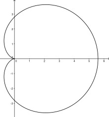
even tho this shape is only fifth place it is still rly good, its nicely shaped and smooth, the wiki page says it was studied a lot, and i agree this type of shape should be studied just ass much as any other shape.
ON 4TH PLACE IS THE RHOMBUS!!!!

BEAUTIFUL NAME AND BEAUTIFUL SHAPE, the name is so great i could just say rhombus every single moment of my life and stay happy. the plurals a Rhombi also its a 4 sided shape with all 4 sides being the same length, just like a square.
3TH PLACE IS THE INTEGER TRIANGLE!!
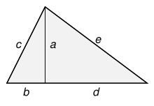
OUTOF ALLL the triangles the integer is my fav triangle of all time, all sides are.. integers, and it is perfect for doing some pythagoring in your free time!
FOR SECOND PLACE IT IS THE ONE THE ONLY
HEXAGON
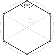
this is one of my more controversial picks, a lot of people in the shape fandom would have chosen hexagon as first place! but i think it is a great second, don't think i dislike the hexagon btw it is a great shape!! amazing repitition!! bee's know the deal. but it could never be as amazing as the amazing, the famous
SQUARE
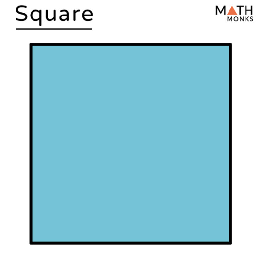
Y'ALL SHOULD KNOW IT I AM A SQUARE LOVER, SQUARE'S ARE SLEAK PERFECT AND SINY, I'D SUCK THE DICK OF A SQUARE IF IT HAD ONE BUT IT DOESN'T CAUS ALL SIDES AND CORNERS ARE THE SAME!!!! AND THAT JUST MAKES ME WANT IT MORE
SQUARES ARE EVERYWHERE, LOOK AT TETRIS? ITS JUST FUCKING CUBES,LOOKAT MINECRAFT (i know its a 3d shape and made out of cubes but a cube is made out of squares so stfu) AS A PIXEL ARTIST I HAVE TO SAY THAT THE SQUARE IS THE BEST SHAPE TO DRAW WITH, ITS PERFECT NOTHING CAN. BECHANGED, Y'ALL SQUARE HATERS CAN SHUT THE FUCK UP
#just shapes and beats#colour#colors#creatures#composition#texture#shapes and colors#geometric shapes#geometric#geometry#geomatics#cube#squares#mathematics#mathblr#calculus#graphs#math#pixel#pixel art#pixelart#pixel illustration#pixel artist#pixel scenery#pixel graphics#pixelated#aseprite#8bit
24 notes
·
View notes

Text

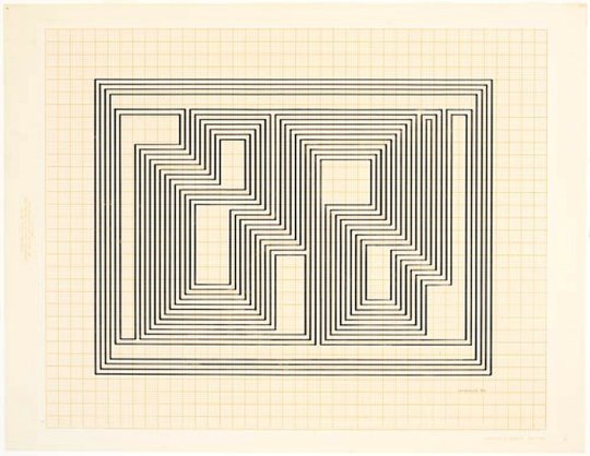

Josef Albers
7 notes
·
View notes
Text

1 note
·
View note
Text
Job Opportunity: Chief Technician - Geography, Geospatial Science, and Earth Observation at the University of Zimbabwe! - February 2025
The University of Zimbabwe’s Faculty of Science, Department of Geography, Geospatial Science, and Earth Observation, is seeking a dynamic and experienced Chief Technician to lead their technical team! If you have a strong background in geospatial sciences and leadership skills, this is a fantastic opportunity to advance your career. About the Role: As the Chief Technician, you will provide…

View On WordPress
#Cartography#Chief Technician Jobs#Earth Observation#Environmental Science#Geography Jobs#Geomatics#Geospatial Science#Harare Jobs#Higher Education#Job Opportunity#Research Jobs#Technical Leadership#University of Zimbabwe#Zimbabwe Jobs
0 notes
Text
Senior Survey Manager (Mining / Open Pit / Geomatics / GIS) – Africa
Job title: Senior Survey Manager (Mining / Open Pit / Geomatics / GIS) – Africa Company: CA Global Job description: Job Description: Our client is seeking an experienced Senior Survey Manager to lead and manage the surveying…. Utilize modern surveying software and equipment. Quality Control: Ensure that all surveying activities meet high standards… Expected salary: Location: Casablanca Job date:…
0 notes
Text
GNSS Precise Orbits or Ephemerides refer to the precise data sets specifying the orbit parameters for a specific satellite at a specific time. These data sets are used by GNSS receivers to derive positions.
GNSS Orbits and Clock Data information is usually distributed in the SP3-d file format (and as a message in a real-time data stream). These IGS products (SP3 files) are typically be classified according to their latency – the length of time between the time of the last observations and the time the file is produced.
Read the full article to find out how to download GNSS Precise Orbits.
1 note
·
View note
Text
I've got voices in my head, telling me I won't make it far
~ FKA twigs
#literature#articles#quotes#eccentricsocietypublications#journals#reading journals#reading notebooks#geometry#geomatics
1 note
·
View note
Text

#mobilephotography #building #geometricedit #creative
1 note
·
View note
Text
Chart Your Course in Geomatics: Find Your Ideal GIS Job Today
You may set yourself up for success in the GIS field right now by being aware of the various career options, developing the necessary skills, navigating the employment market, and making a commitment to lifelong learning. The vibrant discipline of geomatics has a place for you whether your interests are in disaster relief, urban planning, environmental conservation, or any other field. Visit us: https://writethepost.com/chart-your-course-in-geomatics-find-your-ideal-gis-job-today/
1 note
·
View note
Text

Geometric Heart
0 notes
Text
Unlocking Property Potential: NYC's Top Land Surveyors
Are you searching for top land surveyors in NYC? If yes, then you have come to the right place. AAA Group R.E. Servicing Corp. is the best survey company that offers high-quality land surveying services. Our team of professional land surveyors can complete all commercial and residential land surveys with accuracy. We provide services at competitive prices. So, if you want to survey your land or property, you can call us.

#construction#surveyor#surveying#surveylife#landsurveyor#landsurveying#topografia#topography#geomatics#geodesy#surveyors#engineering#landsurvey#surveyworld#realsurveyors#surveyorlife#civilengineering#mapping#geomaticsengineering#mapengineering
0 notes
Text
Geoinformatics Colleges in India: A Comprehensive Guide
Are you passionate about geospatial technology and its applications? Do you want to pursue a career in geoinformatics? If so, you've come to the right place! In this article, we will explore the top geoinformatics colleges in India and provide you with all the information you need to make an informed decision about your future.

What is Geoinformatics?
Before we dive into the details of geoinformatics colleges in India, let's first understand what geoinformatics is all about. Geoinformatics is an interdisciplinary field that combines geography, geology, computer science, and information technology to analyse and interpret spatial data. It involves the use of various tools and techniques to collect, store, process, analyse, and visualise geographic information.
Courses offered for Geoinformatics
If you're interested in pursuing a career in geoinformatics, it's important to know what courses are available and what they entail. Here are some geoinformatics course details offered by geoinformatics colleges in India:
1. Bachelor's Degree in Geoinformatics
A bachelor's degree in geoinformatics is the first step towards building a successful career in this field. This course typically spans over three to four years and covers a wide range of topics such as GIS (Geographic Information System), remote sensing, spatial analysis, database management, and cartography. Some colleges also offer specialised courses in areas like environmental management and urban planning.
2. Master's Degree in Geoinformatics
If you want to further enhance your knowledge and skills in geoinformatics, you can pursue a master's degree in this field. A master's degree program usually lasts for two years and provides advanced training in areas such as geospatial data analysis, geodatabase design, web mapping, and geospatial programming. Many colleges also offer research opportunities for students who wish to delve deeper into specific topics.
3. Diploma/Certificate Courses
Apart from bachelor's and master's degree programs, there are also several diploma and certificate courses available for those who want to gain specialised knowledge in specific areas of geoinformatics. These short-term courses focus on topics such as remote sensing applications, GIS software, and spatial data analysis.
Top Geoinformatics Colleges in India
Now that we have a basic understanding of geoinformatics and its course details, let's take a look at some of the top geoinformatics colleges in India:
Indian Institute of Remote Sensing (IIRS)
Indian Institute of Remote Sensing (IIRS), located in Dehradun, Uttarakhand, is another renowned institute that offers excellent programs in remote sensing and geoinformatics. The institute is affiliated with the Indian Space Research Organization (ISRO) and provides world-class training and research opportunities to students.
National Institute of Technology (NIT) Warangal
National Institute of Technology (NIT) Warangal offers a comprehensive program in geoinformatics at both undergraduate and postgraduate levels. The institute has state-of-the-art facilities, well-equipped laboratories, and experienced faculty members who are actively involved in research projects.
Symbiosis Institute of Geoinformatics (SIG)
Located in Pune, Maharashtra, SIG is one of the premier institutes for geoinformatics education in India. It offers a variety of undergraduate, postgraduate, and diploma programs in geoinformatics. The institute has a state-of-the-art infrastructure, experienced faculty members, and strong industry connections, making it an ideal choice for aspiring geospatial professionals.
Scope of Geoinformatics
After completing your education in geoinformatics, you'll have a wide range of career opportunities to explore. Here are some possible MSc geoinformatics scopes:
1. GIS Analyst: As a GIS analyst, you'll be responsible for collecting, analyzing, and interpreting geographic data using GIS software.
2. Remote Sensing Specialist: Remote sensing specialists use satellite imagery and other remote sensing techniques to gather information about the Earth's surface.
3. Spatial Data Scientist: Spatial data scientists analyze spatial data using statistical techniques to derive meaningful insights.
4. Urban Planner: Urban planners use geospatial technology to develop plans for land use, transportation systems, and urban development.
5. Environmental Consultant: Environmental consultants assess the impact of human activities on the environment using geospatial tools.
These are just a few examples of the career paths you can pursue with an MSc degree in geoinformatics. The demand for skilled professionals in this field is growing rapidly, both in India and abroad.
Conclusion
Geoinformatics is a fascinating field that offers exciting career opportunities for those who are passionate about spatial data analysis and interpretation. By pursuing a degree in geoinformatics from one of the top colleges mentioned above, you’ll gain the necessary knowledge and skills to excel in this field. We recommend SIG from Pune as it offers the perfect blend of education and experience you need for your career ahead.
Remember to thoroughly research each college’s curriculum, faculty expertise, infrastructure, and industry connections before making a decision. Good luck with your academic journey!
1 note
·
View note
Text
Job Opportunity: Senior Technician - Geography, Geospatial Science, and Earth Observation at the University of Zimbabwe! - February 2025
The University of Zimbabwe’s Faculty of Science, Department of Geography, Geospatial Science, and Earth Observation, is seeking a qualified Senior Technician to join their team! If you have a background in environmental science, cartography, geomatics, or related geospatial sciences, and a passion for supporting practical education, this is a great opportunity for you. About the Role: As a…

View On WordPress
#Cartography#Earth Observation#Environmental Science#Geography Jobs#Geomatics#Geospatial Science#Harare Jobs#Higher Education#Job Opportunity#Research Jobs#Technician Jobs#University of Zimbabwe#Zimbabwe Jobs
0 notes