#geospatialtechnology
Explore tagged Tumblr posts
Visit Tumblr Blog
Explore Tumblr blogs with no restrictions, modern design and the best experience.
Last Seen Tumblr Blogs


Fun Fact
Tumblr is used by 21% of adults online aged 18-29 years.
Text
Top AI Tools to Skyrocket Your Website Rankings

In the ever-evolving digital world, staying ahead in search rankings is more competitive than ever. But what if you could work smarter, not harder? That’s where AI-powered SEO tools come into play. These tools help automate tasks, analyze data more effectively, and provide actionable insights that can elevate your website’s visibility in search engines.
Let’s explore the top AI tools that can truly skyrocket your website rankings.
1. Surfer SEO
Best for: Content Optimization
Surfer SEO is a powerful AI tool that helps you create content designed to rank. It compares your content against the top-ranking pages for a keyword and gives real-time optimization suggestions—like ideal word count, keyword usage, and NLP recommendations.
🔍 Key Features:
Content Editor with real-time scoring
SERP Analyzer for competitive analysis
Keyword Surfer Chrome Extension
2. Jasper AI
Best for: Writing SEO-Friendly Content
Jasper AI (formerly Jarvis) is an AI writing assistant that can generate high-quality blog posts, product descriptions, and meta tags. It’s great for marketers who want to scale content production without sacrificing quality.
✍️ Key Features:
Long-form content creation
SEO mode (integrated with Surfer SEO)
50+ content templates
3. Frase.io
Best for: Content Briefs & Answering Search Queries
Frase helps you create content that directly answers user search intent. It analyzes the top results and builds a brief so you can structure your content with maximum SEO impact.
📈 Key Features:
AI-generated content briefs
Question research from Google’s “People Also Ask”
Content scoring system
4. MarketMuse
Best for: Content Strategy & Optimization
MarketMuse uses AI to identify content gaps and helps you create topic-rich, optimized pages. It’s ideal for large sites or agencies working on complex content strategies.
🧠 Key Features:
AI-driven content plans
SERP and competitor analysis
Optimization suggestions with content scoring
5. RankIQ
Best for: Bloggers & Beginners
RankIQ offers a simplified interface and easy-to-use tools that make SEO content creation accessible for bloggers and small business owners. It provides keyword suggestions and outlines for ranking on Google’s first page.
✅ Key Features:
Low-competition keyword library
Content optimizer
Title and SEO score analysis
6. Clearscope
Best for: Enterprise SEO Optimization
Clearscope is trusted by large brands and agencies to refine their content for better performance. It provides a content grade, readability score, and keyword suggestions based on top-ranking pages.
📊 Key Features:
Real-time optimization guidance
Deep keyword and SERP analysis
Integrations with Google Docs & WordPress
7. ChatGPT (OpenAI)
Best for: Idea Generation & SEO Support
ChatGPT isn’t a traditional SEO tool but can be used creatively for keyword ideas, blog outlines, SEO copywriting, and even analyzing competitors if prompted correctly.
💡 Key Features:
Fast brainstorming and outline generation
Can summarize competitor content
Helps write SEO-optimized meta tags and product descriptions
Final Thoughts
AI is no longer the future of SEO—it’s the present. Whether you're a solo blogger or managing enterprise-level websites, the right AI tools can significantly enhance your SEO efforts. By integrating tools like Surfer SEO, Jasper, and Frase, you’ll not only save time but also produce data-driven content that ranks.
Ready to skyrocket your website rankings? Start leveraging AI and let technology take your SEO game to the next level.
#aitools#ai#chatgpt#artificialintelligence#gpt#digitalmarketing#machinelearning#technology#socialmediamarketing#openai#business#tech#o#productivity#aiart#newtech#datamapping#geospatialtechnology#gis#digitaltwins#dmapping#geospatial#marketing#marketingtips#midjourney#lidar#aitechnology#maps#web#entrepreneurship
0 notes
Text
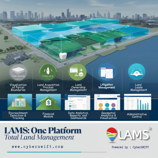
LAMS: One Platform. Total Land Management
Efficient land management is no longer a choice—it’s a necessity. CyberSWIFT’s LAMS (Land Management System) offers a comprehensive digital solution to manage every stage of the land lifecycle, from acquisition to administration.
Visit now at https://lamsapp.com/features
With advanced GIS and geospatial analytics, LAMS enables:
👉 Visualization of plot and parcel boundaries 👉 Streamlined land acquisition process management 👉 Centralized land ownership records 👉 Accurate land valuation 👉 Efficient land lease management 👉 Litigation tracking and resolution 👉 Detection and tracking of encroachments 👉 Integrated financial module for land-related transactions 👉 Detailed data analytics, reports, and dashboards 👉 Geospatial visualization for better decision-making 👉 Administrative control with secure access rights 👉 Full customization and configuration options to meet specific organizational needs
Designed for governments, industrial zones, infrastructure agencies, and enterprises, LAMS empowers users with transparency, accuracy, and control over land resources.
#LandManagement#GeospatialTechnology#LandAcquisition#GIS#DigitalGovernance#CyberSWIFT#SmartCitySolutions#LandAdministration#EncroachmentTracking#LandRecords#LAMS
0 notes
Text
Where maps meet technological advancements—explore how GIS and IoT weave a living tapestry of smart cities, sensing change, guiding growth, and echoing the rhythm of a smarter tomorrow.
#digitaltwins#environmentalmonitoring#geospatialinnovation#geospatialtechnology#gis#gisiotintegration#internetofthings#locationintelligence#realtimegis#smartmaps#spatialanalytics
0 notes
Video
youtube
Space Tech for Weighing Trees | Nature IS | Episode 102 with Florian Reber
#youtube#carbon#geospatialtechnology#climatescience#carbonsequestration#aitraining#geospatialdata#forestconservation
0 notes
Text
📷🖥️ 𝗣𝗵𝗼𝘁𝗼𝗴𝗿𝗮𝗺𝗺𝗲𝘁𝗿𝘆 𝗦𝗼𝗳𝘁𝘄𝗮𝗿𝗲 𝗠𝗮𝗿𝗸𝗲𝘁: 𝗖𝗮𝗽𝘁𝘂𝗿𝗶𝗻𝗴 𝘁𝗵𝗲 𝗪𝗼𝗿𝗹𝗱 𝗶𝗻 𝟯𝗗 𝘄𝗶𝘁𝗵 𝗣𝗿𝗲𝗰𝗶𝘀𝗶𝗼𝗻! 🌍
Photogrammetry software market is rapidly expanding, driven by advancements in 3D imaging and mapping technologies. Photogrammetry software enables precise measurement and visualization by converting photographs into accurate 3D models and maps. This technology is increasingly utilized across various sectors including architecture, construction, archaeology, and gaming. Enhanced capabilities in drone technology and the growing demand for high-quality 3D content are key factors propelling market growth. As industries continue to embrace digital transformation, the photogrammetry software market is poised for significant innovation and expansion.
🔗 𝗔𝗰𝗰𝗲𝘀𝘀 𝘁𝗵𝗲 𝗥𝗲𝗽𝗼𝗿𝘁: https://bit.ly/3KcjKNj

#business#PhotogrammetrySoftware#3DMapping#3d mapping#geospatialtechnology#vr#ar#markettrends#innovations#technolgy#prophecymarketinsights
1 note
·
View note
Text
GIS Services in Canada
GIS services are crucial for RS Solar CAD Group's operations, aiding in site selection, solar panel placement, and infrastructure planning. Our offerings include spatial analysis, data visualization, and custom mapping solutions tailored to meet the unique needs of solar energy projects. With our expertise, RS Solar CAD Group can optimize their designs, minimize environmental impact, and maximize energy production efficiency.
Our Services include Solar Design Services | GIS | CAD/Drafting | BIM | Project management | Civil Engineering | MEP | Permit plan set
To know more contact us Email: [email protected]/ [email protected] or calling / Whatsapp at +919958060424
#gis#geospatial#mapping#geography#cartography#geodata#spatialanalysis#geoinformatics#geospatialintelligence#geospatialtechnology#permit#proposals#engineeringstamp#solar#solarenergy#solarpower#solarinstallation#usa#usajobs#california#washington#oregon#nevada#idaho#montana#arizona#utah#colorado#newmexico#texas
0 notes
Text
Conference

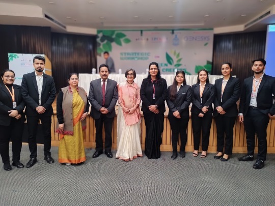


Students of MBA Department along with Dr. Ritu Soryan (HOD MBA) and Prof. Dr. BMK Prasad, Director General, Dronacharya Group of Institutions, Greater Noida attended the "Strategic Workshop on GeoWwise Green Credits: India's Pioneering Initiative" held at India International Centre, New Delhi on 8th February, 2024. Dr. Yogita Shukla, CEO of the addGEO Foundation, warmly welcomed the students.
The aim of the conference is to delve into the nuances of how geospatial information and technology is fundamental to robust water resource management and help communities earn green credits.
#greencredits#geospatialtechnology#geospatialdata#regenerativeeconomy#technology#mbadepartment#students#college#engineeringcollege#g20#cbseboard#delhincr#aicte#aktu#topprivateengineeringcollegeingreaternoida#bestengineeringcollegeindelhincr#DronacharyaGroupofInstitutions#multipleplacement#greaternoida#uttarpradesh
1 note
·
View note
Text
Geoinformatics Colleges in India: A Comprehensive Guide
Are you passionate about geospatial technology and its applications? Do you want to pursue a career in geoinformatics? If so, you've come to the right place! In this article, we will explore the top geoinformatics colleges in India and provide you with all the information you need to make an informed decision about your future.

What is Geoinformatics?
Before we dive into the details of geoinformatics colleges in India, let's first understand what geoinformatics is all about. Geoinformatics is an interdisciplinary field that combines geography, geology, computer science, and information technology to analyse and interpret spatial data. It involves the use of various tools and techniques to collect, store, process, analyse, and visualise geographic information.
Courses offered for Geoinformatics
If you're interested in pursuing a career in geoinformatics, it's important to know what courses are available and what they entail. Here are some geoinformatics course details offered by geoinformatics colleges in India:
1. Bachelor's Degree in Geoinformatics
A bachelor's degree in geoinformatics is the first step towards building a successful career in this field. This course typically spans over three to four years and covers a wide range of topics such as GIS (Geographic Information System), remote sensing, spatial analysis, database management, and cartography. Some colleges also offer specialised courses in areas like environmental management and urban planning.
2. Master's Degree in Geoinformatics
If you want to further enhance your knowledge and skills in geoinformatics, you can pursue a master's degree in this field. A master's degree program usually lasts for two years and provides advanced training in areas such as geospatial data analysis, geodatabase design, web mapping, and geospatial programming. Many colleges also offer research opportunities for students who wish to delve deeper into specific topics.
3. Diploma/Certificate Courses
Apart from bachelor's and master's degree programs, there are also several diploma and certificate courses available for those who want to gain specialised knowledge in specific areas of geoinformatics. These short-term courses focus on topics such as remote sensing applications, GIS software, and spatial data analysis.
Top Geoinformatics Colleges in India
Now that we have a basic understanding of geoinformatics and its course details, let's take a look at some of the top geoinformatics colleges in India:
Indian Institute of Remote Sensing (IIRS)
Indian Institute of Remote Sensing (IIRS), located in Dehradun, Uttarakhand, is another renowned institute that offers excellent programs in remote sensing and geoinformatics. The institute is affiliated with the Indian Space Research Organization (ISRO) and provides world-class training and research opportunities to students.
National Institute of Technology (NIT) Warangal
National Institute of Technology (NIT) Warangal offers a comprehensive program in geoinformatics at both undergraduate and postgraduate levels. The institute has state-of-the-art facilities, well-equipped laboratories, and experienced faculty members who are actively involved in research projects.
Symbiosis Institute of Geoinformatics (SIG)
Located in Pune, Maharashtra, SIG is one of the premier institutes for geoinformatics education in India. It offers a variety of undergraduate, postgraduate, and diploma programs in geoinformatics. The institute has a state-of-the-art infrastructure, experienced faculty members, and strong industry connections, making it an ideal choice for aspiring geospatial professionals.
Scope of Geoinformatics
After completing your education in geoinformatics, you'll have a wide range of career opportunities to explore. Here are some possible MSc geoinformatics scopes:
1. GIS Analyst: As a GIS analyst, you'll be responsible for collecting, analyzing, and interpreting geographic data using GIS software.
2. Remote Sensing Specialist: Remote sensing specialists use satellite imagery and other remote sensing techniques to gather information about the Earth's surface.
3. Spatial Data Scientist: Spatial data scientists analyze spatial data using statistical techniques to derive meaningful insights.
4. Urban Planner: Urban planners use geospatial technology to develop plans for land use, transportation systems, and urban development.
5. Environmental Consultant: Environmental consultants assess the impact of human activities on the environment using geospatial tools.
These are just a few examples of the career paths you can pursue with an MSc degree in geoinformatics. The demand for skilled professionals in this field is growing rapidly, both in India and abroad.
Conclusion
Geoinformatics is a fascinating field that offers exciting career opportunities for those who are passionate about spatial data analysis and interpretation. By pursuing a degree in geoinformatics from one of the top colleges mentioned above, you’ll gain the necessary knowledge and skills to excel in this field. We recommend SIG from Pune as it offers the perfect blend of education and experience you need for your career ahead.
Remember to thoroughly research each college’s curriculum, faculty expertise, infrastructure, and industry connections before making a decision. Good luck with your academic journey!
1 note
·
View note
Text
Unlocking the Secrets of Earth: Key Components of Remote Sensing Explained
In our latest blog, “Components of Remote Sensing”, we break down the essential building blocks behind this powerful technology. Whether you're new to geospatial science or looking to refresh your understanding, this blog provides valuable insights into how raw satellite data transforms into actionable intelligence. With real-world examples and simplified explanations, it’s your go-to guide for mastering the fundamentals.
Ready to explore the science that fuels modern Earth observation? 👉 Read the full article now: https://satpalda.co/components-of-remote-sensing/
#RemoteSensing #GeospatialTechnology #EarthObservation #Satpalda #GIS
0 notes
Text

In today’s fast-paced business world, data-driven decisions are the key to success. MapInfo Pro, a leading GIS software, empowers businesses with advanced spatial analysis and data visualization capabilities. From market analysis and urban planning to environmental management and logistics, MapInfo Pro helps organizations turn complex datasets into actionable insights. In collaboration with Advintek Geoscience, this powerful tool transforms raw data into strategic decisions, improving efficiency, resource management, and competitive advantage.
Discover how MapInfo Pro revolutionizes location intelligence and fuels business growth in this in-depth article!
READ MORE: https://geosciences.advintek.com.sg/visualizing-success.../
#GIS#MapInfoPro#DataDrivenDecisions#LocationIntelligence#BusinessGrowth#SpatialAnalysis#DataVisualization#MarketInsights#GeospatialTechnology#AdvintekGeoScience
0 notes
Text
Happy New Year from Team CyberSWIFT!
As we step into another exciting year, we extend our heartfelt wishes to you and your family for a year filled with joy, success, and new opportunities. May 2025 bring you endless happiness, good health, and prosperity. Let’s continue to innovate, grow, and create incredible moments together!
#HappyNewYear#TeamCyberSWIFT#Welcome2025#NewYearWishes#2025#CyberSWIFT#GISSolutions#GeospatialTechnology#MappingTheFuture#GISInnovation#SmartMapping#SpatialAnalysis#GISForGood#GeoSolutions#GeospatialInsights
0 notes
Text
Choosing the right GIS software in 2025: ArcGIS Pro vs QGIS 3 Analyzed I have just published a comprehensive comparison of the two leading GIS platforms as they stand in 2025. The age-old battle between proprietary and open-source solutions continues, but with fascinating new developments! Both platforms have evolved dramatically since 2020, with QGIS closing many historical capability gaps while ArcGIS Pro has leaned into enterprise integration and AI. Is your organization making the right choice? Well, the answer depends on your specific needs, budget constraints, and strategic priorities. Check out my full analysis to help navigate this critical decision for your mapping needs! Please do have a look at the post, leave a like and comment your thoughts and your experiences working with these softwares. Also do let me know which software do you think is worth investing for? Since it is the AI revolution, which software can perform tasks with utmost simplicity and efficiently, ArcGIS Pro or QGIS 3? Let's get the conversation and engagement going. Do comment, like, share and subscribe to my blog. Your engagement would mean a lot to me. Let's map the world for a sustainable future with Mapping Tomorrow. 🗺️ Subscribe to my blog website: https://mappingtomorrow.wordpress.com and get started with Mapping Tomorrow. Your one step can change your future. SUBSCRIBE NOW and be updated ahead of everyone. #ArcGISPro #QGIS3 #GISSoftware #GISComparison #GeospatialSoftware #GISTechnology #SpatialData #GISMapping #GeographicInformationSystems #OpenSourceGIS #ProprietaryGIS #GISPlatforms #MapChat #GISCommunity #SpatialAnalysis #GIScience #GeoTech #GISProfessional #GISCareer #GISJobs #GISSkills #GISEducation #GISCertification #EsriUser #QGISCommunity #OpenSourceCommunity #EsriUC #FOSS4G #UrbanPlanning #EnvironmentalGIS #BusinessIntelligence #LocationIntelligence #DataVisualization #TechComparison #SoftwareReview #2025Tech #OpenSource #TechDecisions #SoftwareEvaluation #MappingTomorrow #ProfessionalDevelopment #TechTrends #IndustryInsights #GISTwitter #MapTwitter #TechTwitter #GISLife #MappingCommunity #TechTools #GISResources #GeospatialTechnology #MappingTools
#ai#arcgispro#artificial-intelligence#cartography#education#environment#geographicinformationsystems#geospatialinelligence#geospatialtech2030#gis#gisanalysis#gissoftware#mapping#qgis#technology
0 notes
Text
"Optimizing Operations with Geospatial Solutions"
Geospatial solutions harness the power of location-based data to provide valuable insights and support informed decision-making across various industries.
https://www.globalinsightservices.com/request-sample/GIS23655@/?utm_source=SnehaPatil-Article
By integrating geographic information systems (GIS), satellite imagery, and GPS technology, these solutions enable organizations to analyze spatial patterns, optimize resource allocation, and improve operational efficiency. From urban planning and environmental management to logistics and agriculture, geospatial solutions offer versatile tools for visualizing data, predicting trends, and addressing complex challenges. With the proliferation of IoT devices and advancements in data analytics, geospatial solutions continue to evolve, empowering businesses and governments to unlock new opportunities and create sustainable, resilient communities. #Geospatial #GIS #LocationIntelligence #SpatialAnalysis #DataVisualization #SmartCities #IoT #GeospatialTechnology #DecisionMaking #UrbanPlanning #EnvironmentalManagement #Logistics #Agriculture #SustainableDevelopment #Resilience
0 notes
Link
1 note
·
View note
Text
#aitools#ai#artificialintelligence#digitaltwin#indoormapping#newtech#geospatialdata#datamapping#gis#mapping#geospatialtechnology#gismapping#dmapping#geospatial#dmap#digitaltwins#machinelearning#lidar#onpassiveai#onpassive#assetmapping#maps#fieldmapping#aitechnology#dataextraction#earth#voxelmaps#utilitymapping#onpassiveaitools#dmodeling
0 notes