#geospatialanalysis
Text


🌍 Exploring Geography insights through a conversation between an expert and an enthusiast! Discover the dynamics of our planet and the fascinating aspects of its diverse landscapes. 🗺️✨
#Geography#ExpertAndEnthusiast#EarthSciences#GeospatialAnalysis#WorldExplorer#GeographicalKnowledge#PlanetEarth#GlobalInsights
0 notes
Text
Data preparation for AI-fueled Geospatial Analysis

Its been ages since businesses, governments, researchers, and journalists are using satellite data that helps understand the physical world and take action. As the geospatial industry evolves, so are the ways in which geospatial professionals use data to solve problems. Satellite imagery contains information that is useful for data-related projects. That’s why we’re seeing the rise of AI and ML in this industry.
Geospatial intelligence provides geographical information and distribution of elements in a geographic space and is now an essential tool for everything, from national security to land use and planning to agriculture and a host of commercial and government functions.
AI and Computer Vision for Geospatial Analysis
Artificial intelligence (AI) is revolutionizing the field of geospatial analysis by providing advanced tools and techniques to process and analyze vast amounts of geospatial data. Geospatial data includes information about the Earth's surface, such as satellite imagery, aerial photographs, and geographic information systems (GIS) data.AI algorithms and computer vision techniques are used to extract meaningful insights from geospatial data. These technologies enable automated data processing, pattern recognition, and scalable analysis, significantly improving the efficiency and accuracy of geospatial analysis tasks.
One of the key advantages of using AI in geospatial analysis is the ability to process large volumes of data quickly. Traditional manual methods of analyzing geospatial data can be time-consuming and labor-intensive. AI-powered algorithms can analyze massive datasets in a fraction of the time, enabling faster decision-making and response.AI also enhances the accuracy of geospatial analysis by reducing human error and subjectivity. Computer vision algorithms can detect and classify objects in satellite imagery, such as buildings, roads, and vegetation, with high precision. This helps in various applications like urban planning, disaster response, and environmental monitoring. Below are a few applications of Geospatial AI which cater to many industries and use cases:
Object detection
One of the primary applications of AI and Computer Vision in geospatial and satellite imagery is object detection and recognition. Through deep learning algorithms, AI models can accurately identify and classify objects such as buildings, roads, vegetation, and water bodies in satellite images. This capability is crucial for urban planning, environmental monitoring, disaster response, and infrastructure development.
Classification
Another significant use case is land cover classification, which involves categorizing different land types based on satellite imagery. AI algorithms can analyze multispectral and hyperspectral data to identify land cover classes like forests, agricultural fields, urban areas, and water bodies. This information is vital for land management, ecological studies, and monitoring of changes in land use over time.
Anomaly detection
AI and Computer Vision also play a crucial role in change detection and anomaly detection in geospatial imagery. By comparing satellite images taken at different times, AI models can identify changes in the landscape, such as deforestation, urban expansion, or natural disasters. This helps in monitoring environmental changes, detecting illegal activities, and supporting disaster management efforts.
Furthermore, AI-powered image segmentation techniques enable the extraction of detailed information from geospatial imagery. For instance, semantic segmentation can accurately delineate different land cover classes within an image, while instance segmentation can identify and track individual objects or features of interest. These capabilities find applications in precision agriculture, infrastructure monitoring, and resource management.
Map better with Data preparation for Geospatial AI
Accurate training data is essential for geospatial AI applications to provide precise and reliable results to users. Geospatial AI involves analyzing and interpreting data related to geographic locations, such as maps, satellite imagery, and spatial databases. Training data acts as the foundation for training machine learning algorithms and models in geospatial AI systems. Here are the typical steps involved in data preparation for geospatial AI:
Data Collection
Data collection involves gathering relevant geospatial data from various sources. This can include satellite imagery, aerial photography, GIS databases, GPS data, sensor data, and user-generated content. The data collection process should align with the specific requirements of the geospatial AI application. For example, if the application involves mapping and navigation, data collection may focus on obtaining accurate and up-to-date map data, including road networks, points of interest, and traffic information. If the application is related to land use analysis, data collection may involve acquiring satellite imagery with land cover information. The goal is to collect a diverse and representative dataset that encompasses the geographical area of interest.
Data Curation
Data curation involves the process of cleaning, organizing, and preparing the collected geospatial data for training AI models. This step is crucial for ensuring the accuracy, consistency, and quality of the data. Data cleaning entails removing duplicate records, addressing missing or erroneous values, and handling outliers or noise present in the dataset. It may also involve standardizing the data formats, ensuring consistent coordinate systems, and resolving any inconsistencies or conflicts within the data. Additionally, data curation may involve preprocessing steps like rescaling or normalizing numerical attributes to facilitate effective model training. The goal of data curation is to create a refined and reliable dataset that is ready for subsequent analysis and model training.
Data Annotation
Data annotation is the process of labeling or tagging specific features or regions of interest within the geospatial data. It involves assigning semantic or spatial labels to the data to provide the necessary ground truth for training supervised AI models. In geospatial AI, annotation can encompass various tasks such as object detection, segmentation, classification, or tracking. For example, in satellite imagery, data annotation may involve marking buildings, roads, vegetation, or water bodies. In aerial imagery, it could involve labeling objects like vehicles, pedestrians, or buildings. The annotation process can be performed manually by human annotators with domain expertise or using automated tools in some cases. Data preparation services encompass various annotation techniques tailored to geospatial applications.

Point Annotation: Point annotation involves marking specific points or coordinates within geospatial data. It is commonly used for tasks that require pinpointing precise locations or points of interest. For example, annotating specific addresses, landmarks, or geographic coordinates enables accurate geocoding, location-based searches, or geofencing.

Image Classification: Image classification in geospatial AI enables tasks such as environmental monitoring, land use planning, infrastructure assessment, or change detection. It provides valuable insights and information by automatically categorizing and analyzing large volumes of geospatial data. Data annotation experts classify objects in images based on custom taxonomies, such as land, road, vehicles, residential properties, and more.

Conclusion
Data preparation plays a pivotal role in the success of geospatial AI applications, enabling accurate and reliable results in various geographic contexts. Geospatial AI relies on diverse and precise data, collected from various sources, to train models effectively. By emphasizing TagX's expertise in each step of the data preparation cycle, we demonstrate our ability to deliver high-quality geospatial AI solutions. Our proficiency in data collection, curation, and annotation ensures that the training data we provide is accurate, reliable, and tailored to meet the unique requirements of our clients. With our comprehensive data preparation process, we empower users to leverage geospatial AI effectively and achieve their goals with super-sharp results.
0 notes
Text
International Regional Science Review Journal and Magazine Subscription
Worldwide Regional Science Review (IRSR), distributed quarterly, is a global gathering for business analysts, geographers, organizers, and other social researchers to share significant exploration discoveries and methodological leap forwards. Zeroing in on issues of hypothesis, technique, and public approach where the spatial or local measurement is focal, IRSR endeavors to advance valuable insightful exploration that is safely attached to this present reality.
#RegionalScienceReview#IRSRMagazine#RegionalResearch#GeospatialAnalysis#EconomicDevelopment#UrbanStudies#SpatialEconometrics#RegionalPolicy#GeographicAnalysis#RegionalEconomics#magazine#magazinesubscriptions
0 notes
Link
Geographic information systems. There, I've lost a few of you already, but you're missing out because GIS is more than about where things are, but why they're there, and quite a few of those reasons are around why people do people things. Helen McKenzie is a cartographer, data visualiser, and geospatial advocate who is passionate about finding meaning in complex data and making information beautiful.
We speak about Helen's love of maps and how we can use geospatial analysis to elegantly give us more meaning to the way we live in the world around us and keep our societies ticking away.
About Helen McKenzie
Helen McKenzie is a Geospatial Advocate which means her job is to get people excited about all things geospatial! She has been working in the geospatial industry for around 10 years and has recently made the move from consultancy to technical marketing, whether that's through running live workshops or writing blogs about using GIS to choose the best venue for the Eurovision Song Contest.
Twitter: @helenmakesmaps
Instagram: @helen.makes.maps
LinkedIn: https://www.linkedin.com/in/helenmckenzie003
Watch or listen on your favourite platform.
Show Notes
[00:01:32] How Helen found her way to geography and GIS.
[00:05:04] Helen's dissertation combining Jane Austen and GIS.
[00:08:57] What does work in geospatial sciences look like?
[00:12:04] The depth of detail in understanding our communities.
[00:15:19] Michele talks about warm data again because warm data is cool.
[00:17:06] GIS is about engagement with the data and making those connections.
[00:21:00] Becoming a geospatial advocate.
[00:27:20] Understanding from geospatial data and its value to businesses.
[00:29:25] The cost and factors involved in opening a new store branch.
[00:32:29] Michele has too many bubble tea shops nearby. Her local area could have benefitted from some geospatial data.
[00:34:14] What does a geospatial advocate do?
[00:39:55] Finding your audience.
[00:41:46] What Helen doesn't like about her work.
[00:42:48] The challenges of public speaking.
Follow STEAM Powered
YouTube
Facebook
Instagram
Twitter
Patreon
0 notes
Video
youtube
Geospatial Analysis: Transforming Our World in 2024# #youngresearchers#a...
Geospatial analysis in 2024 is revolutionizing how we understand and interact with our environment. By integrating advanced technologies like AI, remote sensing, and big data, geospatial analysis provides critical insights for urban planning, disaster management, environmental conservation, and more. This transformative tool helps visualize complex data, uncover patterns, and make informed decisions, driving innovation across various sectors and improving quality of life globally.
Hashtags: #ResearchPioneer #ScienceMentor #ScientificDiscovery #ScienceEducation#STEMAdvocate #GeospatialAnalysis #GIS #RemoteSensing #BigData #UrbanPlanning #DisasterManagement #EnvironmentalConservation #AI #DataVisualization #Innovation2024#Postdoc #LabWork #FieldResearch #DataScience #InnovationInScience #ResearchImpact #sciencecommunication
International Young Scientist Awards
Website link: youngscientistawards.com
Nomination Link : https://x-i.me/suwyou5
Contact Us: [email protected]
Social Media:
Twitter : https://twitter.com/youngsc06963908
Linkedin- : https://www.linkedin.com/in/shravya-r...
Pinterest : https://in.pinterest.com/youngscienti...
Blog : https://youngscientistaward.blogspot....
Tumblr : https://www.tumblr.com/blog/shravya96
0 notes
Text
Exploring the Top Providers for 9 Types of Location Data

In today's data-driven world, location data is a goldmine for businesses and decision-makers. But who are the go-to providers for various types of location data? Let's dive in and explore some of the best:
GPS Data: GPS giants like Garmin and TomTom are trusted sources for accurate global positioning data, crucial for navigation and tracking.
Geocoding Services: Google Maps Geocoding and HERE Geocoder offer precise geocoding services, converting addresses into geographical coordinates.
Mapping and Navigation: Google Maps and Apple Maps lead the way in providing comprehensive mapping and navigation data, vital for location-based services.
Real-time Traffic Data: Waze, now owned by Google, stands out for real-time traffic updates, helping users avoid congestion.
Retail Foot Traffic Data: Placer.ai and SafeGraph are known for offering valuable insights into foot traffic patterns, assisting retailers and investors.
Weather Data: The Weather Channel and AccuWeather are reliable sources for location-specific weather forecasts and historical data.
Social Media Location Data: Social platforms like Facebook and Twitter provide location data through user check-ins and geotagged posts, aiding marketers.
IoT Location Data: Companies like Sigfox and LoRaWAN provide IoT-specific location data, supporting IoT applications and asset tracking.
Local Business Data: Yelp and Yellow Pages offer rich information on local businesses, helping users find services in their vicinity.
When it comes to location data, the key is reliability, accuracy, and relevance to your specific needs. Choosing the right provider can significantly impact your business strategies and decision-making processes. So, explore these options, assess your requirements, and unlock the power of location data for your endeavors! #LocationData #DataProviders #GeospatialAnalysis
0 notes
Photo
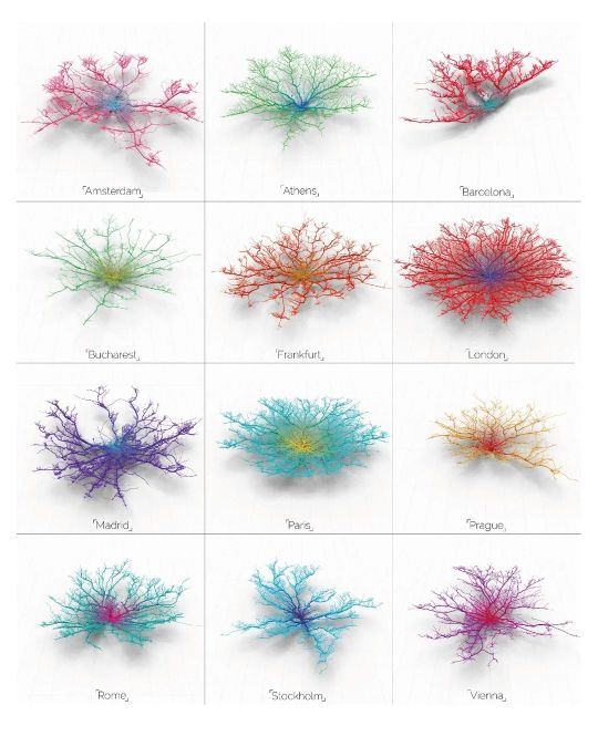
Follow @urbandesign.lab Coral Cities | An Ito Design Lab Concept "For the past six months I have been fascinated by the concept of making city networks look like living corals. The varying patterns of urban forms are inherently dictated by their road network; a complex, seemingly organic connection of links moving people across their city. Like branches of coral they have a pattern and a function, I chose to expose this pattern and manipulate it to become something far more conceptual. Read Less." Project by: @mapzilla_art (Craig Taylor) DM for credits/Removal. . . . . Photoshop Masterclass (2 Days Integrated Workshop) Session Details: • Day 1: 18th of February, 2023 | Urban Mapping • Day 2: 19th of February, 2023 | 3D Urban Visualization 🔗Registration link in the bio Limited Seats available! Early Bird registration ends on 12th February, 2023 . . . . #mapping #urbanplanning #GISmapping #urbandesign #nollimaps #citymapping #geospatial #geography #cartography #spatialdata #cityplanning #dataanalysis #sustainability #landscapearchitecture #smartcities #placemaking #geodata #opendata #mapmaking #urbanism #geospatialanalysis #urbanrenewal #3Dmapping #wayfinding #environmentaldesign #mobility #transportationplanning #urbanregeneration #publicspace #urbandesignlab (at United States) https://www.instagram.com/p/CorxtBRvDuB/?igshid=NGJjMDIxMWI=
#mapping#urbanplanning#gismapping#urbandesign#nollimaps#citymapping#geospatial#geography#cartography#spatialdata#cityplanning#dataanalysis#sustainability#landscapearchitecture#smartcities#placemaking#geodata#opendata#mapmaking#urbanism#geospatialanalysis#urbanrenewal#3dmapping#wayfinding#environmentaldesign#mobility#transportationplanning#urbanregeneration#publicspace#urbandesignlab
0 notes
Photo

. Once upon a day, when we learn how to use RTK . #landscape #beach #nature #class #rtkday #geospatialanalysis #coastalmanagement #fieldtrip #mcop #evs #uncw #globalseahawks #springsemester2018 #wrightsvillebeach #wilmington #wilmingtonnc #northcarolina #iphoneonly #snapseed #panols #iphonography (at Wrightsville Beach, North Carolina) https://www.instagram.com/p/BvxYdlvFfNx/?utm_source=ig_tumblr_share&igshid=n4gd8nz80jzs
#landscape#beach#nature#class#rtkday#geospatialanalysis#coastalmanagement#fieldtrip#mcop#evs#uncw#globalseahawks#springsemester2018#wrightsvillebeach#wilmington#wilmingtonnc#northcarolina#iphoneonly#snapseed#panols#iphonography
2 notes
·
View notes
Photo


000016 - COVID-19 in India
Data: https://www.mohfw.gov.in/
Cases shown in the images are updated as of 04 October 2020, 08:00 AM IST
NOTE: Cases for Lakshadweep are shown as 0 in all images as the data for the UT is not given on the above site.
India - State Boundaries Map is provided by Data{Meet} Community Maps Project. It's made available under the Creative Commons Attribution 2.5 India.
Choropleth map of Cases by State created using Python 3.7.9.
Modules used: pandas, geopandas and matplotlib.pyplot.
#choroplethmap#geospatialanalysis#datavisualization#datascience#python#pandas#geopandas#matplotlib#pyplot#india#covid_19#corona#coronavirus#coronaindia#programming#data#covid#covid19#covid19india
0 notes
Photo
#Map #cartographer #cartography #cartographyart #mapitaly #mapez #MAPPhotograpy #mapiful #mappedcake #mappinguav #MapsTimeNow #gis #gisanalyst #geologists #geospatialanalysis #geoafrikana #gischat https://www.instagram.com/p/B2Z85XVhiwZ/?igshid=pvw5ixfur5kf
#map#cartographer#cartography#cartographyart#mapitaly#mapez#mapphotograpy#mapiful#mappedcake#mappinguav#mapstimenow#gis#gisanalyst#geologists#geospatialanalysis#geoafrikana#gischat
0 notes
Photo
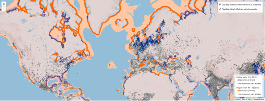
Mapping Global Wind Power Potential
https://www.iea.org/offshorewind2019/Geospatialanalysis/
5 notes
·
View notes
Photo
From the bottom of my geographical heart I want to say Thank you for all of the birthday wishes. I love technology not only because I work in it but because it allows everyone to give birthday wishes from across the state, county, and world 🌎. It is a great thing to have a purpose and calling. I am thankful for God’s provision in my life. Here’s to many more days and the new tech that will be available in the future. #birthdaythanks #thankyou #gis #geospatialanalysis #geogeek #gisday #geografia #geography #birthday #blesseddad #blessedhusband
#geogeek#blesseddad#gis#gisday#geospatialanalysis#geografia#birthday#thankyou#blessedhusband#geography#birthdaythanks
0 notes
Photo

Brooklyn building ages built in QGIS
148 notes
·
View notes
Photo

In this book, you’ll learn how to view, edit and analyse geospatial data in QGIS. You’ll also learn how to leverage the power of Python 3 for your spatial analysis using QGIS. Learn more: geoafrikana.com/shop See link in bio. . . . . . . . . . . . . . . #gischat #qgis #map #cartographyart #gis #geospatialanalysis #foss4g #foss #mapping #geoafrikana #ebook #pythonprogramming #python #pyqgis https://www.instagram.com/p/B1L9HFYhuL1/?igshid=1s044gt4krydo
#gischat#qgis#map#cartographyart#gis#geospatialanalysis#foss4g#foss#mapping#geoafrikana#ebook#pythonprogramming#python#pyqgis
0 notes
Photo

Learn how to make stunning maps with QGIS 3.x. QGIS is free and open-source software for GIS (FOSS4G). Like other FOSS, QGIS has abundant tutorials and great community support. However, many of these tutorials are based on older versions of the software. #gischat #qgis #map #cartographyart #gis #geospatialanalysis #foss4g #foss #mapping #geoafrikana #ebook https://www.instagram.com/p/B1L8fsoB9PU/?igshid=nxyle4pgmb6a
0 notes
Video
instagram
In place editing with #qgis #gis #gisanalyst #geospatialanalysis #geoafrikana #arcgisonline #esri https://www.instagram.com/p/B7lzvcSBhD6/?igshid=1jqtltgze1ogx
0 notes
Last Seen Blogs

rockfluffer-blog
what is a title

leangreenninjateen
The greatest ninja to ever live!

danhsachvang
Danh Sách Vàng

boss130214-blog
曾搖動我的天空

mabelofy
░⠀ྀ𖹭྄ִ̣̣⠀̇̇̇⠀̥⠀ֺ𝖻ᥱ᤻𝖻ִᥱ𑂲