#gisat
Text

Luna-25 to Moon, targets landing ahead of Chandrayaan-3
#luna25#moon#chandrayaan3#russia_launched_luna_25#SpaceSecrets#nasa#earthobservationsatellite#indiamoonmission#chandrayaan#moonmission#EOS#ISRO#SpaceTechnology#GISAT#ksiddhartha#thoughtleadership#knowledgeeconomy#gigeconomy#ensembleiasacademy#geographyoptional#k_siddharthasir#ias#civilservices#upsc_motivation#upsc_aspirants#upsc_exam#best upsc coaching centre#best upsc online classes#ias coaching centres#ias coaching classes
1 note
·
View note
Text
Sentinel-1 monitora la deforestazione Amazzonica
Utilizzo di un data cube per monitorare la perdita di foreste in Amazzonia. Gli ecosistemi forestali stanno subendo rapidamente gli impatti dei cambiamenti climatici e il monitoraggio tempestivo delle foreste sta diventando sempre più urgente.
Un progetto guidato dall'ESA, Sentinel-1 for Science: Amazonas, ha elaborato miliardi di immagini radar dell'intero bacino amazzonico e le ha convertite in un data cube, aiutando a rilevare la perdita di foreste.
Un data cube è un modo semplice per organizzare e visualizzare qualsiasi tipo di dati in più dimensioni, ottenendo informazioni su modelli e tendenze che potrebbero non essere immediatamente evidenti in un grafico o grafico tradizionale.
Da gennaio 2017 a novembre 2021, il team ha rilevato una perdita di foreste di oltre 5,2 milioni di ettari, che corrisponde all'incirca alle dimensioni del Costa Rica.
Le foreste detengono una grande quantità di carbonio terrestre della Terra e svolgono un ruolo importante nel compensare le emissioni antropogeniche di combustibili fossili. Dal 2015, le foreste tropicali del mondo possono essere osservate regolarmente a un intervallo senza precedenti da 6 a 12 giorni grazie alla missione Copernicus Sentinel-1.
Milioni di gigabyte di dati radar ad apertura sintetica (SAR) vengono acquisiti sia di giorno che di notte, indipendentemente dalla copertura nuvolosa, foschia, fumo o aerosol, consentendo il monitoraggio della deforestazione e del degrado forestale almeno bisettimanale.
La sfida, tuttavia, sta nel trovare metodi adeguati per estrarre indicatori significativi della perdita di foreste dalle grandi quantità di dati radar in arrivo, in modo tale che le anomalie nelle serie temporali possano essere rilevate regolarmente e in modo coerente nelle foreste tropicali.
Tali metodi di monitoraggio delle foreste dovrebbero essere trasparenti e facilmente comprensibili per il grande pubblico, consentendo la fiducia nel loro utilizzo in vari settori pubblici e privati.
Il progetto Sentinel-1 for Science: Amazonas presenta un approccio semplice e trasparente all'utilizzo delle immagini del radar satellitare Sentinel-1 per stimare la perdita di foreste. Il progetto utilizza un data cube spazio-temporali (noto anche come StatCubes), in cui le informazioni statistiche rilevanti per identificare la deforestazione vengono estratte in ogni punto della serie temporale radar.

Perdita di foreste in tutta l'Amazzonia
Con questo approccio, il progetto dimostra l'uso dei dati di Sentinel-1 per creare un'analisi dinamica della deforestazione nel bacino amazzonico. Il team è stato in grado di rilevare la perdita di foreste di oltre 5,2 milioni di ettari dal 2017 al 2021, che è all'incirca la dimensione del Costa Rica.
Neha Hunka, esperta di telerilevamento presso Gisat, ha commentato: “Quello che stiamo vedendo dallo spazio è oltre un milione di ettari di foreste umide tropicali che scompaiono ogni anno nel bacino amazzonico, con l'anno peggiore che è il 2021 in Brasile. D'ora in poi possiamo tenere traccia di queste perdite e riferirle in modo trasparente e coerente ogni 12 giorni".

Perdita forestale di 'Tile 20LMQ'
Miliardi di pixel dai satelliti Sentinel-1 dall'inizio del 2015 a dicembre 2021, ognuno dei quali rappresenta una foresta di 20 x 20 m, sono armonizzati nell'ambito del progetto StatCubes e un semplice approccio di soglia per rilevare la perdita di foresta è dimostrato nella prima versione di i risultati.
La sfida più grande del progetto è stata la grande quantità di gestione ed elaborazione dei dati. Il team ha utilizzato diversi strumenti software intuitivi per accedere ai dati in modo efficiente, elaborando oltre 450 TB di dati per creare le mappe della perdita di foreste.
Anca Anghelea, Open Science Platform Engineer presso l'ESA, ha aggiunto: "Fornendo dati e codice ad accesso aperto attraverso l'Open Science Data Catalogue dell'ESA e la piattaforma openEO, miriamo a consentire ai ricercatori di tutto il mondo di collaborare e contribuire all'avanzamento delle conoscenze sul nostro foreste globali e il ciclo del carbonio.

Confronto delle dimensioni della perdita forestale
"Pertanto, nell'ultima fase del progetto, un focus chiave sarà su Open Science, riproducibilità, mantenimento a lungo termine ed evoluzione dei risultati raggiunti nel progetto Sentinel-1 for Science: Amazonas".
A seguito del progetto, il prossimo obiettivo è quello di ottenere un prodotto della perdita di carbonio dai cambiamenti della copertura del suolo, lavorando insieme al team Climate Change Initiative dell'ESA, un obiettivo che contribuirà al Carbon Science Cluster dell'ESA.
I risultati attuali del progetto sono ora disponibili cliccando qui. Sentinel-1 for Science Amazonas è implementato da un consorzio di quattro partner: Gisat, Agresta, l'Università Norvegese di Scienze della Vita e l'Istituto di Ricerca Geospaziale Finlandese. Il team combina in modo univoco esperienze complementari e solide in silvicoltura e valutazioni del carbonio, analisi SAR multitemporale e fusione di dati e capacità di elaborazione di dati di grandi dimensioni.
Read the full article
0 notes
Text
Vězeň číslo 35 132
Josef Čapek prožil celou válku v koncentračních táborech. 1. září 1939 jej v Želivě u Humpolce zatklo gestapo. Od té doby se výtvarně nadaný umělec píšící před zatčením do Uměleckého měsíčníku, pro časopis Volné směry, ale i pro Národní listy a Lidové noviny nikdy nedostal na svobodu.
Josef Čapek byl první zářijový den gestapem zatčený v rámci akce Albrecht I, kdy během rozsáhlého zátahu bylo zatčeno mnoho intelektuálů i dalších potenciálních nepřátel nacistů. Nechyběl mezi nimi ani Josef Čapek, kterého nejprve odvlekli na Pankrác, pak jeho další cesta vedla postupně do koncentračních táborů Dachau, Buchenwald, Sachsenhausen a Bergen-Belsen.
youtube
Čapek nemohl v koncentráku tvořit, byl ve velmi složitých a nelidských podmínkách, mučený a tyranizovaný jako všichni určeni v koncentráku ke smrti. Takže převážně Čapek tajně kreslil malé obrázky, tzv. “dlaňovky”. V koncentráku v úkrytu dřevěné kůlničky pokud mohl vytvořil stovky obrázků, které po válce vdova Jarmila dle příkazu zničila.
Josef Čapek zemřel v průběhu dubna roku 1945, tedy jen několik málo dní před koncem války. V únoru 1945 byl Josef Čapek spolu s dalšími vězni převezen v otevřených vagónech za silného mrazu do Bergen-Belsen, kde po dvou měsících v průběhu dubnových dnů na vyčerpání organismu a na tyfus zemřel.
Nacistická nenávist zavraždila, utýrala před 78 lety Josefa Čapka podobně jako miliony dalších nevinných obětí. I proto bychom se měli mít na pozoru před neofašismem a neonacismem, který je stále více k vidění v nejrůznějších podobách mezi flasteneckou proruskou dezoscénou, krajní pravici i krajní levicí.
Zdroj: https://twitter.com/gisat/status/1652598972031148034

Životopis
Josef Čapek, mnohostranná osobnost meziválečného období, se narodil 28. března 1887 v Hronově. Byl to malíř, grafik, dramatik, prozaik a autor próz pro děti, žurnalista, výtvarný teoretik a kritik.

Slovesné dílo Josefa Čapka se vyvíjelo v těsném vztahu k tvorbě výtvarné. Zpočátku psal s bratrem Karlem krátké prózy, které postupně dokumentují vývoj obou autorů v kontaktu s dobovými stylovými tendencemi – od secese přes novoklasicismus po kubismus. Rozsáhlou část díla Josefa Čapka tvoří studia, eseje a fejetony o umění.
Otec Josefa Čapka byl lékař a osvětový pracovník, matka byla sběratelkou literárního folkloru. Oba sourozenci Josefa Čapka – Karel a Helena – byli spisovatelé. Dětství prožil v Malých Svatoňovicích a v Úpici.
Josef Čapek vystudoval německou tkalcovskou školu ve Vrchlabí. Roku 1904 odešel natrvalo do Prahy, kam se později přestěhovala celá rodina. V letech 1904 – 1910 studoval malbu a kresbu na Uměleckoprůmyslové škole v Praze.

Již za studií navázal kontakty s uměleckým a literárním světem. V letech 1910 – 1911 pobýval studijně v Paříži.
Po návratu do Čech byl kratší dobu redaktorem Uměleckého měsíčníku. Potom vstoupil do spolku Mánes a spoluredigoval jeho časopis Volné směry.
Spolu s bratrem Karlem a s S.K. Neumannem se podílel na vydání generačního Almanachu na rok 1914. V období mezi válkami se vedle malířství, knižní grafiky a scénického výtvarnictví věnoval novinářské a literární činnosti. Pracoval v Národních listech, v letech 1921 – 1939 pak v Lidových novinách.
Vzhledem k tomu, že se intenzivně angažoval v protifašistickém zápase, byl již 1. září roku 1939 zatčen a vězněn v koncentračních táborech.
Josef Čapek zemřel na sklonku 2. světové války, a to v dubnu 1945 v Bergen-Belsenu v Dolním Sasku pravděpodobně na tyfus. Symbolický hrob je v Praze na Vyšehradském hřbitově.
0 notes
Photo
Orbital no: 18 of 2020 First ever launch for ISRO, in 2020 and GSLV Mk2 with upgraded varient (4m ogive payload fairing gives extra space to host wider Payloads). GSLV Mk2 will launch the first ever GEO Stationary Imaging Satellite (GISAT) for India. . . . . #isro #isromissions #pslv #shar #sriharikota #satishdhawanspacecentre #gslvmkii #gslv #gslvmkiii #gisat #gsat #image #earthfocus #rocketry #chandrayaan2 #chandrayaan #mangalyaan #ogive #india #science #technology #gslvf10 #rocketlaunch #spacex #nasa #esa #geo #ritcheychretien #telescope #nkknspacepage (at Satish Dhawan Space Centre - SDSC, SHAR) https://www.instagram.com/p/B9E7wZlpiEI/?igshid=1cr53em2ey8jo
#isro#isromissions#pslv#shar#sriharikota#satishdhawanspacecentre#gslvmkii#gslv#gslvmkiii#gisat#gsat#image#earthfocus#rocketry#chandrayaan2#chandrayaan#mangalyaan#ogive#india#science#technology#gslvf10#rocketlaunch#spacex#nasa#esa#geo#ritcheychretien#telescope#nkknspacepage
0 notes
Text
Isro's EOS-03 Satellite Fails to Reach its Orbit, Blast's off due to Unusual performance.
Isro's EOS-03 Satellite Fails to Reach its Orbit, Blast's off due to Unusual performance.
#Isro #GISATT #satellite #sri hari kota #rocket laucn #eos 3 #elonmusk #tech #mba #startup
Isro’s first launch of 2021 fails in the middle. Isro’s EOS-03 Satellite launched on Thursday, 12-August-2021. The launch took place at 0543Hrs IST. The Earth observation satellite (EOS) before reaching orbit, got failed due to failure in the cryogenic stage.
Isro’s “GSLV-F10 got failed after a flight of 340 seconds which is around (5min 40 seconds). The primary and secondary stages went well as…

View On WordPress
#business#EOS-01#gisat-1 satellite isro launch date#gslv fat boy#gslv mark 4#gslv rocket#gslv-f10#hindustan times#how many times isro failed#isro careers#isro chairman#isro established#isro failed mission#isro failed mission 2019#isro failed missions 2020#isro failure#isro full form#isro launch today#isro live#isro live earth#isro live satellite#isro rocket failed#list of rocket launching stations in india#mba#reasons of isro rocket failure#reasons of rocket failure#Satellite#sounding rocket isro#startup#tech
0 notes
Text
இஸ்ரோவின் ஜி.எஸ்.எல்.வி, EOS-03 புவி கண்காணிப்பு செயற்கைக்கோளை விண்ணில் செலுத்தப்படும்
விளக்கப்படம் / Space Intelligence / homemdoespaco
ஆகஸ்ட் 12, 2021 அன்று இந்திய நேரபபடி அதிகாலை 05:43, நெல்லூர் அருகே ஸ்ரீ ஹரிகொடா சதிஷ் தவன் விண்வெளி மையத்தில் இருந்தது இஸ்ரோவின் EOS-03 புவி கண்காணிப்பு செயற்கைக்கோளை, ஜி.எஸ்.எல்.வி (GSLV-F10) ஏவுகணை வாகனத்தை பயன்படுத்தி, புவிநிலைச் சுற்றுப்பாதை நோக்கி ஏவப்படும்
EOS-03(GISAT-1) செயற்கைகோள்
இஸ்ரோவின் நவீன புவி கண்காணிப்பு செயற்கைக்கோள், முதல்…

View On WordPress
0 notes
Text

ISRO Created History | अंतरिक्ष में रचा इतिहास | चांद पर फहराया तिरंगा | Chandrayaan-3 Landing
#ISRO_Created_History#moon#chandrayaan3#luna25#SpaceSecrets#nasa#earthobservationsatellite#indiamoonmission#chandrayaan#moonmission#EOS#ISRO#SpaceTechnology#GISAT#ksiddhartha#thoughtleadership#knowledgeeconomy#gigeconomy#ensembleiasacademy#geographyoptional#k_siddharthasir#ias#civilservices#upsc_motivation#upsc_aspirants#upsc_exam#best upsc online classes#ias coaching centres#ias coaching classes#online coaching for ias
1 note
·
View note
Text
Indian Space Research Organization
#isro conspiracy case#isro.gov.in#isro gisat 1 geo imaging satellite launch date august 12 postponed delay covid 19 coronavirus isro#isro espionage case#isro vikas engine#isro
0 notes
Text
ISRO is back.
Indian Space Research Organisation (ISRO) also known for its low budget spacecraft is set to launch GSLV rocket with geo image satellite (GISAT-1).

The launch will happen in 12 August,2021 from Sriharikota Launchpad.
GISAT-1 will help India to get real time images of the country and its borders which will help to look after any illegal activities of the borders.
It will also help to determine any type of natural disaster over the country before hand.
1 note
·
View note
Text
India set to launch advanced geo-imaging satellite Gisat-1 on August 12; Check out details
India set to launch advanced geo-imaging satellite Gisat-1 on August 12; Check out details
Three days prior to the 75th Independece Day celebrations, India will launch its most advanced geo-imaging satellite – Gisat-1. This satellite will allow the government to better monitor the country’s borders, especially with Pakistan and China, through imaging the sub-continent 3-4 times daily.
The COVID-19 pandemic had delayed the launch of Gisat-1 multiple times this year, but the satellite…
View On WordPress
#EOS-3#geo-imaging satellite#gisat-1#Gisat-1 news#gisat-1 satellite launch#gisat-1 satellite news#isro#ISRO gisat-1 launch#ISRO satellite launch
0 notes
Text
Latest News Today - ISRO Plans to Launch GISAT-1 Geo-Imaging Satellite on
Latest News Today – ISRO Plans to Launch GISAT-1 Geo-Imaging Satellite on
The Indian Space Research Organisation (ISRO) is getting back into launch activity fully at Sriharikota spaceport with the planned orbiting of geo imaging satellite GISAT-1 on board GSLV-F10 rocket on August 12. It’s going to be only the second launch of the Bengaluru-headquartered space agency in the COVID-19-hit 2021. ISRO successfully launched PSLV-C51 mission on February 28 with Brazil’s…

View On WordPress
#GeoImaging#gisat-1#GISAT1#gslv-f10#ISRO#isro gisat 1 geo imaging satellite launch date august 12 postponed delay covid 19 coronavirus isro#Latest#Launch#news#Plans#Satellite#Today
0 notes
Text
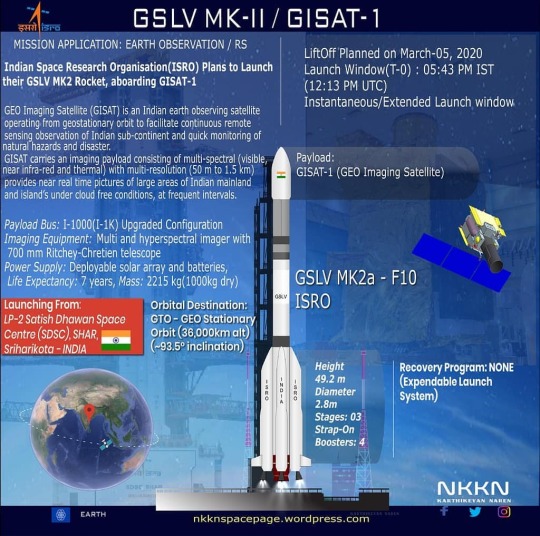
ISRO calls off GISAT-1 launch due to technical reasons - ETtech
ISRO calls off GISAT-1 launch due to technical reasons – ETtech
[ad_1]

India’s space agency said the launch of earth observation satellite GISAT-1 has been postponed due to technical reasons. Indian Space Research Organisation (ISRO) had planned to launch the earth observation satellite on March 05.
The ISRO said the “revised launch date will be informed in due course” without disclosing specific details on the technical reasons or glitches.
The satellite…
View On WordPress
0 notes
Text
satellite data services market – Industry Trends and Forecast to 2027
Market Overview
The Global Satellite Data Services Market is projected to be valued at USD 21.54 Billion by 2025, registering a CAGR of 19.4% from 2019 to 2025. Factors such as the increasing number of private firms in the space industry and significant advancements in geospatial imagery analytics are driving the growth of the market. Furthermore, the increasing demand for small satellites for earth observation across the globe is projected to aid the growth of the market.
Get Free Sample Copy of “satellite data services market” @
https://www.marketresearchfuture.com/sample_request/8562
Competitive Landscape
Airbus SE (Netherlands)
Blacksky (US)
Digitalglobe, Inc. (US)
Earth-I Ltd (UK)
Geospatial Intelligence Pty Ltd (Australia)
Gisat SRO (Czech Republic)
Harris Geospatial Solutions, Inc. (US)
Imagesat International (Israel)
Planet Labs, Inc. (US)
Market Segmentation
Environmental monitoring segment is expected to be the fastest-growing: The environmental monitoring segment is expected to exhibit the highest CAGR during the review period. The increasing use of satellite data for meteorology and the prevention of illegal fishing and tree felling is driving the growth of the segment.
Access Full Report Details and Order this Premium Report @
https://www.marketresearchfuture.com/reports/satellite-data-services-market-8562
Regional Analysis
Image data segment accounted for the larger market share in 2018: The image data segment is also expected to exhibit higher CAGR during the forecast period. This growth can be attributed to the increasing use of satellite image data for monitoring crops, flooding, icebergs, and coastal traffic.
Related Report Link:
https://www.marketresearchfuture.com/reports/air-traffic-control-equipment-market-7037
https://www.marketresearchfuture.com/reports/gunshot-detection-system-market-7034
https://www.marketresearchfuture.com/reports/remotely-operated-vehicle-market-7023
NOTE: Our Team of Researchers are Studying Covid19 and its Impact on Various Industry Verticals and wherever required we will be considering Covid19 Footprints for Better Analysis of Market and Industries. Cordially get in Touch for More Details.
About Market Research Future
At Market Research Future (MRFR), we enable our customers to unravel the complexity of various industries through our Cooked Research Report (CRR), Half-Cooked Research Reports (HCRR), Raw Research Reports (3R), Continuous-Feed Research (CFR), and Market Research & Consulting Services.
MRFR team have supreme objective to provide the optimum quality market research and intelligence services to our clients. Our market research studies by products, services, technologies, applications, end users, and market players for global, regional, and country level market segments, enable our clients to see more, know more, and do more, which help to answer all their most important questions.
In order to stay updated with technology and work process of the industry, MRFR often plans & conducts meet with the industry experts and industrial visits for its research analyst members.
Contact
Market Research Future
Office No. 528, Amanora Chambers
Magarpatta Road, Hadapsar,
Pune - 411028
Maharashtra, India
+1 646 845 9312
Email: [email protected]
0 notes
Text
Indian Space Association Set to Be Launched Today by Prime Minister Narendra Modi: All the Details
Indian Space Association Set to Be Launched Today by Prime Minister Narendra Modi: All the Details
Indian imaging satellite GISAT-1 by the ISRO
Prime Minister Narendra Modi will virtually launch the Indian Space Association (ISpA) at 11 am on Monday. He will also interact with representatives of the space industry on the occasion.
Taking to Twitter, the Prime Minister on Sunday wrote, “At 11am tomorrow, 11th October, I will join the programme to launch the Indian Space Association. I am glad…

View On WordPress
0 notes
Text
ISRO Suffers Setback in GISAT-1 Satellite Mission After Technical Anomaly
ISRO Suffers Setback in GISAT-1 Satellite Mission After Technical Anomaly
Indian Space Research Organisation (ISRO) suffered a setback while trying to put the GISAT-1 earth observation satellite into orbit, due to a technical anomaly minutes after the rocket carrying the satellite was launched in the early hours on Wednesday.
“Performance of first and second stages was normal. However, Cryogenic Upper Stage ignition did not happen due to technical anomaly. The mission…
View On WordPress
0 notes
Text
Страны БРИКС договорились делиться спутниковыми данными
Космические агентства стран БРИКС (Бразилия, Россия, Индия, Китай, ЮАР) заключили соглашение об обмене данными по дистанционному зондированию Земли.
Соглашение поможет странам БРИКС создать виртуальную группировку спутников дистанционного зондирования и наладить обмен данными.
Встреча глав космических ведомств стран БРИКС прошла 18 августа в формате видеоконференции.
В конференции участвовали гендиректор «Роскомоса» Дмитрий Рогозин, президент Бразильского космического агентства Карлус Моура, председатель Индийской организации космических исследований доктор Кайласавадиву Сиван, глава Китайской национальной космической администрации Чжан Кэцзянь, исполнительный директор Южноафриканского национального космического агентства доктор Валанатан Мунсами, и представители внешнеполитических ведомств стран – участниц БРИКС.
Пока нет деталей того, какие именно данные и как будут циркулировать между подписавшими соглашение странами. Из всех участниц БРИКС только у ЮАР нет собственных спутников дистанционного зондирования.
За неделю до подписания соглашения Индия потеряла свой спутник: при запуске на орбиту спутника дистанционного зондирования Земли GISAT-1/EOS-03 на ракете тяжелого класса GSLV MkII не сработала верхняя ступень – пишет Habr.com.
Поддержите проект Цифролагу.Нет
0 notes
Last Seen Blogs

usenmeyenanne
Üşenmeyen Anne

redclawblogs666
Red_Claw Blogs

ozyellow93
Diary of Oz

esportsduniya
EsportDuniya.in

buggbuzz
buggiepie