#lidar point cloud processing
Explore tagged Tumblr posts
Visit Tumblr Blog
Explore Tumblr blogs with no restrictions, modern design and the best experience.
Last Seen Tumblr Blogs


Fun Fact
Tumblr.com is the 103rd most visited website in the world.
Text
It was greatly applied in satellite tracking. With its help, laser-based imaging and calculation of distances were made easy by measuring the time for a signal to return using appropriate sensors and data acquisition equipment.
0 notes
Text
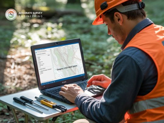
Unleashing the Potential of Lidar: Innovative Data Processing Approaches
In the ever-evolving realm of technology, Lidar (Light Detection and Ranging) has emerged as a game-changing technology with applications spanning from autonomous vehicles to environmental monitoring. However, the true power of Lidar lies in its data processing capabilities. In this blog post, we will explore innovative data processing approaches for Lidar technology and how Polosoft Technologies is at the forefront of harnessing its potential.
I. The Rise of Lidar Technology

Lidar, a remote sensing technology that uses laser pulses to measure distances and create detailed 3D maps of environments, has gained substantial traction in recent years. The applications of Lidar are vast, including autonomous driving, surveying, archaeology, and forestry management, among many others. This technology has revolutionized data collection, but the real magic happens in the data processing phase.
II. Traditional Data Processing vs. Innovative Approaches
Traditional data processing for Lidar involves basic filtering and point cloud generation. While this approach is adequate for many applications, innovative methods have the potential to take Lidar to new heights. Here's a comparison of the two:
Traditional Data Processing:
Filtering out noise and unwanted points.
Basic point cloud generation.
Limited to basic applications.
Innovative Data Processing:
Advanced noise reduction algorithms.
Enhanced point cloud processing, including feature extraction.
Expanded applicability to complex scenarios, such as urban environments and forestry.
III. Polosoft Technologies: Pioneering Innovative Lidar Data Processing
At Polosoft Technologies, we have embraced the power of Lidar and are continuously pushing the boundaries of what this technology can achieve. Our innovative data processing approaches for Lidar include:
Noise Reduction Algorithms:
We've developed cutting-edge noise reduction algorithms that significantly improve the quality of Lidar data, making it suitable for even the most demanding applications.
Feature Extraction:
Our advanced data processing techniques enable us to extract valuable features from Lidar point clouds, such as building outlines, vegetation, and road infrastructure. This opens up new possibilities for applications like urban planning and forestry management.
Object Recognition:
Leveraging Lidar data, we have pioneered object recognition algorithms that can identify and classify objects like vehicles, pedestrians, and road signs. This is a crucial component for autonomous driving and advanced security systems.
Integration with AI:
We've seamlessly integrated Lidar data with AI and machine learning models, enabling real-time decision-making and analysis in various industries.
IV. Real-World Applications
The innovative Lidar data processing approaches developed by Polosoft Technologies have far-reaching implications across industries. Some notable applications include:
Autonomous Vehicles:
Lidar data is instrumental in helping self-driving cars navigate and avoid obstacles. Our advanced data processing ensures the highest level of safety and reliability.
Environmental Monitoring:
Lidar-equipped drones and aircraft can monitor forests and other ecosystems with unmatched precision, aiding in conservation and resource management.
Infrastructure Planning:
Lidar data is used to assess and plan urban infrastructure, making cities more efficient and sustainable.
Disaster Management:
Rapid mapping of disaster-stricken areas using Lidar technology helps first responders and authorities to make informed decisions and save lives.
V. Conclusion
The true potential of Lidar lies in its innovative data processing approaches, and Polosoft Technologies is at the forefront of this transformation. By pushing the boundaries of Lidar technology, we are enabling a new era of applications across various industries. As Lidar continues to evolve and advance, the possibilities are limitless, and Polosoft Technologies is committed to staying at the forefront of this exciting field. Join us in embracing the power of Lidar and unlocking a world of possibilities.
#lidar services#lidar technology#lidar data processing#lidar classification#lidar point cloud classifications
0 notes
Text
Theories about Legion's "mini headlamps" (N7 special)
A very happy N7 Day to all of you Mass Effect fans!
Although I still haven't finished Mass Effect 3 (I just haven't been able to pick it up again after the Rannoch arc), I nevertheless wanted to do something special for this occasion, and I thought to myself that I might as well devote a quick study to a subject that's been on my mind for quite a long time: the purpose of Legion's three additional "mini headlamps".
You see, aside from the big, obvious flashlight in the middle, Legion also possesses three smaller lights at the side of their head. Ever since discovering these, I've been wondering what exactly those are for. I've observed that they glow red when Legion is under "stress" (an effect which is unfortunately not present in the Legendary Edition) - or rather, in situations that require a lot of processing power - but as far as their practical function goes, I could only guess. However, going through the ME3 dialogues again, I noticed a small detail which could potentially explain what exactly those small lights are - and in addition, give us a little insight into how Geth perceive the world visually.
Disclaimer: Before going into this, I should mention that I have no technical education in robotics, laser scanning, or any related areas of engineering. I based my conclusions solely on what information I could find on the internet, as well as my own reasoning and observations.
[Potential spoilers for ME3]
LADAR/LiDAR scanning and three-dimensional perception
To start off, what basically led me on this track was this comment by Tali in ME3:
Their AI lets them use extremely detailed ladar pings. Xen's countermeasure overwhelmed them with garbage data.
First off, we need to clarify what exactly ladar is. LADAR, more commonly known as LiDAR, stands for "Light amplification by Stimulated Emission of Radiation detection and ranging" - or, in case of LiDAR, "Light detection and ranging/Light imaging, detection and ranging. It's a method for measuring the distance, speed, and surface structure of objects by the means of laser scanning, usually with beams in the infrared spectrum (there are different wavelengths of light in use, however). Essentially, LiDAR is based on the same principle as the echolocation of bats, the only difference being the use of light instead of sound. Every LiDAR system consists of three integral components: a transmitter, a receiver, and a timer. The transmitter will send out a laser beam, which will be reflected by the object it hits; afterwards, the reflection will be registered by the receiver. Because the speed of light is a known constant, the distance of the object can be deduced by the timer, which will determine the delay between the light impulse being send out and the reflection being captured, also known as "time of flight".
However, because each laser beam only represents the coordinates of a single point, multiple laser beams are necessary to create a detailed 3D map of the environment. Some LiDAR lasers, like those used in automated vehicles, pinwheel to collect data in a 360° radius, generating a 3D image of all objects in the vicinity, including cars, pedestrians, and other obstacles. This results in multiple "points" forming a "point cloud" together, digitally depicting the surroundings on a 3D level. Because each laser emits hundreds of impulses per second, this technology enables you to take highly precise measurements in a very short period of time. LiDAR technology is not only utilized in autonomous driving, but also all kinds of other areas too, like archaeology, topographical mapping, and monitoring of vegetation growth.
Now, with this in mind, my theory is that Legion's small headlamps are the transmitter and receiver components of the LiDAR system - more specifically, I think the transmitters are located on the right, while the singular light on the left is the receiver. However, since we know that normal scanning LiDAR requires multiple laser beams for a detailed 3D image, the question is why Legion would only have two of them implemented. Personally, my suspicion is that the Geth might be using a flash LiDAR: Flash LiDAR is a different type of LiDar emitting a single wide, diverging beam, similar in shape to the beam of a flashlight. By projecting the reflected light onto a sensor array, a flash LiDAR can create a complete 3D environment without the use of multiple impulses. In addition to being very compact, flash LiDAR sensors have no moveable parts, making them extremely resistant to any kind of vibration - an undeniable advantage in all situations that require quick movement, such as combat.
Analysis of atmospheric composition with LiDAR
Still, that doesn't explain why Legion would have an additional transmitter on the right side of their head. We do know, however, that the laser scans with LiDAR are precise enough to not only measure the exact distance between objects, but also analyze the density of particles in the air: Because the molecules in the air cause the light from the laser beam to backscatter, LiDAR is also utilized in monitoring air quality and detecting fine dust, being able to determine traces of atmospheric gases such as ozone, nitrous gases, carbon dioxide, and methane. Depending on the wavelength of light used, the LiDAR system might be more or less precise in measuring molecular backscattering. For that reason, LiDAR systems using multiple wavelengths of light are most efficient in determining the exact size distribution of particles in the air.
With this in mind, let's take a look at Legion's opening line in ME2 upon entering the Heretic station:
Alert. This facility has little air or gravity. Geth require neither.
Going by what I explained above, the reason why Legion was able to tell there is no oxygen in the atmosphere isn't because they have some built-in chemical sensors to analyze the air's components - it's because they can literally "see" the particles in the air.
Thus, I think the second transmitter on the right side of Legion's head might use a different kind of wavelength specifically intended for the detection of atmospheric particles, perhaps in the UV-spectrum (the general rule is that the shorter the wavelength, the higher the resolution of the 3D image is, and since UV has a shorter wavelength than infrared, I imagine it might be used for this purpose). Meanwhile, the big flashlight in the middle might be a photoreceptor, being able to detect "normal" light visible to humans. In addition, the Geth are probably able to see UV-light (since the Quarians are able to see it, it would be logical to assume the Geth are as well), and maybe even infrared and other wavelengths. To summarize the function of all of Legion's headlights, I imagine it works roughly like this:

The two lights on the right side of Legion's head (marked with a red and magenta line) might be LiDAR transmitters, using infrared and UV-light, respectively; the single small light on the left (circled with green) might be the LiDAR sensor/receiver, while the big light in the middle (circled with blue) might be a photoreceptor (Source)
The effect of Xen's countermeasure (and potential means to bypass it)
It might be difficult to imagine from a human point of view, but judging from the information that the Geth use LiDAR as their main method of depth perception, Tali describing Xen's invention as a "flash bang grenade" actually makes a lot of sense: If you're normally able to observe your surroundings down to a molecular level, it would probably feel very disorienting if you're suddenly not, not to mention being unable to tell whether an object is far away or close by (which would be absolutely devastating if you suddenly come under attack).
Still, that doesn't mean there are no potential alternatives: Radar, which has been in use longer than LiDAR, is another method to determine the range, angle, and velocity of objects. Due to radar using long-waved micro- and radio waves, the measurements are generally a lot less precise than those with LiDAR; despite this, radar still has its use during inclement weather, when LiDAR systems are very prone to disturbances by dust, mist, and rainfall. Furthermore, LiDAR can only provide measurements up to 200 meters, while radar is more efficient at greater distances. In fact, most modern autonomous driving vehicles work both with LiDAR and radar, in addition to a conventional camera (the only vehicles that don't use LiDAR are those from Tesla, which have a reputation of being unsafe). So, it's only reasonable to assume that the Geth don't rely on LiDAR alone, but use various technologies in combination with it to compensate for each one's weaknesses.
Interestingly, a type of 4D radar is currently in development, intended to be used in autonomous driving. It provides 3D images with a similar resolution as LiDAR, at a potentially much cheaper cost. Still, whether LiDAR or 4D radar is the better choice for autonomous driving is still a heatedly debated question, and only time will tell which of both systems comes out on top. Nevertheless, assuming Xen's "flash bang grenade" only targets the Geth's LiDAR sensors, I wonder if they could've potentially found a way to adapt and bypass it, given enough time.
Anyway, that's the material for a different kind of analysis - for now, I hope you enjoyed this little deep dive into the science behind the Geth. Thank you all for reading and have a nice N7 Day! :-)
#mass effect#mass effect legion#geth#mass effect lore#lore theories#lidar technology#my contribution to N7 Day
18 notes
·
View notes
Text
Top Tools for Creating High-Impact 3D Map Illustrations in Architecture

Mastering the Landscape: Top Tools for Creating High-Impact 3D Map Illustrations in Architecture
In the dynamic world of architecture and urban planning, communication is key. Whether you're pitching a master plan, showcasing a new development, or explaining complex infrastructure, conveying spatial relationships and contextual nuances is paramount. While traditional 2D maps provide basic information, they often fall short in capturing the imagination or truly illustrating the depth and impact of a project within its environment. This is where high-impact 3D Map Illustration steps in, transforming flat data into compelling, easily digestible, and aesthetically rich visual narratives.
This blog will explore the leading software and workflows that empower designers to create high-impact 3D Map Illustration for architectural projects, ensuring their visions are understood and embraced.
The Power of 3D Map Illustration in Architectural Communication
Before diving into the tools, it's essential to understand why 3D Map Illustration is so vital in architecture:
Holistic Understanding:
It provides a bird's-eye view of a project within its entire context, including existing buildings, topography, and proposed developments. This is crucial for large-scale urban planning projects or complex architectural complexes.
Enhanced Clarity:
Complex spatial relationships, pedestrian flows, and vehicular routes become immediately apparent, simplifying otherwise intricate data.
Stakeholder Engagement:
Visuals are universally understood. A powerful 3D Map Illustration can bridge the gap between technical details and public understanding, fostering buy-in from diverse audiences, including investors, city officials, and local communities.
Design Validation:
Architects can use these maps to test and refine their designs in a real-world context, identifying potential issues or opportunities before construction.
Foundation of Precision: 3D Vector Maps Software
The bedrock of any high-impact 3D Map Illustration is accurate, scalable geographic data, best handled by software that generates 3D Vector Maps. Unlike raster images, vector data can be scaled infinitely without losing quality, making it ideal for maps that need to be viewed at various zoom levels.
Here are the top tools for creating and working with 3D Vector Maps:
GIS Software (e.g., ArcGIS Pro, QGIS):
Geographic Information Systems are the gold standard for handling spatial data. They allow architects to import real-world topographical data (like LiDAR point clouds or DEMs), aerial imagery, and existing building footprints. GIS software can then process this data to create accurate 2D and 3D base maps. While not directly creating the artistic render, they provide the precise foundation of the 3D Vector Maps from which the illustration will emerge. QGIS is a powerful open-source alternative, making professional-grade 3D Vector Maps accessible.
CAD Software (e.g., AutoCAD, MicroStation):
These can be used to generate precise 2D and 3D building outlines, roads, and landscape elements, which can then be imported into more specialized 3D modeling environments. While primarily used for technical drawings, their precision is vital for the accuracy of 3D Vector Maps in an architectural context.
Vector Graphics Software (e.g., Adobe Illustrator, Affinity Designer):
While not inherently 3D, these tools are invaluable for refining the 2D elements that often form part of 3D Vector Maps. They can be used to create clean lines, labels, icons, and legends that enhance the clarity and aesthetic appeal of the final 3D Map Illustration.
Sculpting the Vision: Architecture Illustration Tools
Once the precise 3D Vector Maps are established, the next step involves bringing the architectural elements to life with artistic flair and realism. This is where dedicated 3D modeling and rendering software, often used for Architecture Illustration, plays a crucial role.
Here are the leading tools for crafting detailed Architecture Illustration:
Autodesk Revit / ArchiCAD (BIM Software):
Building Information Modeling (BIM) software is increasingly becoming the starting point for architectural projects. Revit and ArchiCAD allow architects to create intelligent 3D models of their buildings, complete with material information and structural data. These models can then be directly exported or linked to rendering engines to create the core of the Architecture Illustration. Their ability to manage complex building data makes them ideal for ensuring accuracy in the Architecture Illustration embedded within the 3D Map Illustration.
Trimble SketchUp:
Known for its user-friendliness and intuitive interface, SketchUp is excellent for quick 3D massing studies, conceptual design, and creating detailed architectural components. While it may require plugins for advanced rendering, its ease of use makes it a popular choice for rapidly prototyping the architectural elements that will populate the 3D Map Illustration.
Blender:
This Cycles and Eevee render engines can produce stunning photorealistic results, making it a highly versatile tool for creating every aspect of a detailed Architecture Illustration. The active community and constant development make Blender an increasingly popular choice for professional Architecture Illustration.
Autodesk 3ds Max / Maya:
These are industry-standard 3D software packages renowned for their advanced modeling, animation, and rendering capabilities. They offer unparalleled control over scene setup, lighting, and material creation, making them ideal for producing the highest quality photorealistic Architecture Illustration for complex projects and large-scale 3D Map Illustration. Their extensive feature sets allow for meticulous detail and artistic expression.
Bringing it All Together: Rendering and Compositing for High-Impact 3D Map Illustration
The final step in creating a high-impact 3D Map Illustration involves bringing together the precise 3D Vector Maps and the detailed Architecture Illustration elements, then rendering them with compelling lighting and post-production effects.
Key rendering and compositing tools include:
V-Ray / Corona Renderer
These are highly regarded photorealistic rendering engines that integrate with various 3D modeling software. They offer advanced lighting, material, and camera controls, allowing artists to achieve stunning realism, depth, and atmosphere in their 3D Map Illustration.
Twinmotion / Lumion (Real-time Renderers):
These tools are gaining immense popularity due to their speed and ease of use. While perhaps not reaching the absolute pinnacle of photorealism as offline renderers, they produce excellent results quickly and are fantastic for iterating on the overall look and feel of the 3D Map Illustration or creating short animations.
Adobe Photoshop / Affinity Photo (Image Editing/Compositing):
After rendering, post-production is crucial for refining the final 3D Map Illustration. These image editing software packages allow artists to adjust colors, contrast, add atmospheric effects (like fog or haze), integrate labels, legends, and other graphic elements, and even subtly enhance certain details to make the Architecture Illustration truly pop within the overall map.
Conclusion
Creating high-impact 3D Map Illustration in architecture is a multidisciplinary art form that blends technical precision with artistic vision. By leveraging the power of software that generates accurate 3D Vector Maps, sculpts detailed Architecture Illustration, and refines the final image through advanced rendering and compositing, architects and visualization transform urban plans into easy-to-understand visual narratives.
0 notes
Text
/https://www.linkedin.com/pulse/us-lidar-point-cloud-processing-software-market-jxhze/
0 notes
Text
Comprehensive Guide to Scan to BIM Services: Transforming Construction and Infrastructure Projects

The construction world is going through a major shift. Digital tools now play a key role in making projects quicker, cheaper, and more accurate. Among these tools, Building Information Modeling (BIM) stands out. It helps teams visualize and plan projects better than ever before.
Scan to BIM services take this process even further. They combine laser scanning with 3D modeling to give real-world accuracy in digital plans. This method captures buildings, bridges, and other structures just as they are in the real world. It’s a game changer for getting precise, detailed data for any project.
What Are Scan to BIM Services?
Definition and Purpose
Scan to BIM is a process that uses laser scanning to create detailed digital models. These models show the exact shape, size, and condition of existing structures. The main goal? To give construction teams the most accurate as-built data possible. This helps prevent mistakes and saves time during design and building phases.
How It Works
The process starts with laser scanners that shoot out laser beams to measure surroundings. These scanners collect millions of data points, creating what’s called a point cloud. The data then gets cleaned up and organized. Next, skilled modelers turn this point cloud into a usable 3D BIM model.
Technologies like LiDAR sensors, mobile laser scanners, and drones make this process fast and detailed. The result is an exact digital replica of the real-world structure.
Industry Adoption and Trends
The market for scan to BIM is growing fast. More companies see how accurate data saves money and reduces delays. Big industries such as facilities management, historic building renovations, and new construction are using these services. Experts expect the market to stay strong as technology gets cheaper and better.
Key Components of Scan to BIM Services
Laser Scanning Technology
Different scanners serve different needs. Static laser scanners stay in one place, capturing high-detail data. Mobile scanners mounted on vehicles can quickly scan large areas. Drones are used for high, hard-to-reach places.
High-resolution scans keep details sharp, making it easier for team members to spot issues or plan repairs.
Data Processing and Point Cloud Generation
Raw scans are huge and unorganized. Data processing turns this chaos into useful information. The raw data becomes a point cloud—a 3D map of the environment. The process involves registration, where multiple scans are aligned, cleaning to remove errors, and management for easy access and sharing.
BIM Modeling and Integration
Once the point cloud is ready, modelers create accurate 3D models fitting various BIM platforms like Revit or Navisworks. This creates a comprehensive digital mockup. These models can then be shared and edited easily by different teams, ensuring everyone stays on the same page.
Validation and Quality Control
Before finalizing, the models are checked for errors. Validation ensures measurements match reality, and quality checks confirm that all details are correct. Fixing mistakes early saves headaches later.
Benefits of Scan to BIM Services
Enhanced Accuracy and Detail
Thanks to laser scans, the models are o to 1 replicas of the real thing. That means fewer surprises, less rework, and better project planning.
Time and Cost Savings
Getting detailed data quickly means less time on site and fewer trips back to fix mistakes. It also cuts costs linked to errors during construction or renovation.
Improved Collaboration and Communication
Sharing a common, digital model makes teamwork smoother. Everyone from architects to managers can see the same up-to-date info. Real-time updates boost transparency and decision-making speed.
Lifecycle Management
Beyond building, scan to BIM supports maintenance and upgrades. Facility managers use these models for inspections, repairs, or future renovations. This long-term view helps save money years later.
Applications and Real-World Examples
Renovation and Retrofit Projects
Historic buildings often need careful updates. Scan to BIM provides detailed as-built data, preserving the building's character while upgrading its systems. One example? Restoring old churches or libraries with minimal risk of damaging original features.
Facility Management and Maintenance
Hospitals and large complexes benefit from digital twins created through scan to BIM. Staff can locate pipes, wiring, or HVAC systems without invasive digging, saving time and money.
Construction Planning and Clash Detection
Before breaking ground, teams use models to spot conflicts, like pipes crossing beams. This prevents delays, reduces rework, and keeps projects on track.
Infrastructure and Civil Projects
Bridges, tunnels, and roads undergo regular assessments. Laser scans detect deterioration or damage early, helping to plan repairs before problems worsen.
Challenges and Limitations
Technical Challenges
Processing large amounts of scan data can be tricky and requires high computing power. Some environments, like dense urban areas, still pose difficulties for current scanners.
Implementation Barriers
High-quality scanners can be expensive, and training personnel takes time. Integrating scan to BIM into existing workflows isn’t always smooth.
Data Security and Privacy
Sensitive project details must be protected. Data breaches can be costly, so companies need robust security policies. Additionally, regulatory rules vary by location.
Future Trends and Innovations
Advancements in Scanner Technology
We can expect even faster, lighter, and more precise scanners. Portable options will make data collection easier on-site.
AI and Machine Learning Integration
Artificial intelligence will automate much of data processing. It will quickly identify issues, suggest modifications, or generate models automatically.
Expanded Use Cases
Future applications include augmented reality displays for on-site guidance and smart city planning. These innovations will make infrastructure projects smarter and more connected.
Actionable Tips for Implementing Scan to BIM
Start with a clear goal and assess what you need from the process.
Invest in reliable scanners and train your team or hire experts.
Work with experienced service providers for best results.
Protect sensitive data with strong security measures.
Keep your BIM models updated and maintained for ongoing use.
Scan to BIM services are transforming how we approach building and infrastructure projects. They boost accuracy, cut costs, and improve collaboration. As technology advances, their role in construction will only grow.
If you want to stay ahead, start exploring how scan to BIM can help your next project. Digital tools aren’t a future trend—they're here now, ready to change the way we build. Don’t wait—integrate these solutions and see the difference they make.
1 note
·
View note
Text
How GIS Technology is Transforming the UAE Landscape? Learn How Data Processing Shapes the Future
Picture how at dawn, a surveyor watches the sun cast its shadows over Dubai from atop the Burj Khalifa. The data below describes a nation that turned deserts into shining cities within a short period. This is a real story because GIS Surveys and Data Processing make a big difference in planning, constructing, and managing cities in the UAE.
The Overview of Smart Cities
The smart city initiatives in every emirate in the United Arab Emirates rely heavily on Geographic Information Systems (GIS). In Dubai and Abu Dhabi, GIS surveys help ensure that decision-makers in these cities use spatial data effectively.
Today, GIS surveys in the UAE gather information about buildings, roads, the environment, and the population’s demographics. As a result, this system helps city planners organize all the parts of the city more efficiently and make the city a nicer place for its people.
Advanced Methods for Surveying in the Desert
GIS professionals in the UAE have to deal with challenges and take advantage of the country’s unique geography. In view of the country’s fast development and its arid climate, the need for precise and quick data collection is inevitable. Surveying equipment used today is equipped with advanced technologies.
LiDAR Technology: millions of precise points are collected about what is on the ground which is then used to form highly detailed 3D images. This technology has helped to track the many changes in the UAE’s landscape, from near the sea to far within the mountains.
Merging Satellite Photos and Data: Using high-resolution satellite images, real-time information about land use is obtained and used to improve maps that track China’s fast growth. It allows authorities to observe how things are progressing in the city, follow how it is growing, and notice any changes in the environment.
Mobile Mapping Systems: Sensors installed on vehicles gather data from the streets, resulting in complete databases of different parts of a road network. In highly congested urban places, these systems can be more useful than traditional types of surveying.
Data Processing: From Raw Information to Actionable Intelligence
GIS is particularly useful because it makes collecting data meaningful through processing large volumes of spatial information. Most recent survey methods create large datasets, but the UAE can now process this data with ease.
Thanks to cloud processing, those responsible can quickly look at results from the survey and make decisions based on conditions as they stand. Thanks to machine learning, it becomes easier to plan for future challenges rather than respond only to them as they occur.
GIS maps are updated frequently when paired with IoT sensors. Understanding the complexity of cities improves by using smart traffic systems, monitoring environmental conditions, and overseeing utilities.
Relevant uses of AI making a difference in the Emirates
Many important projects in the UAE demonstrate the effects of advanced GIS technology.
Infrastructure Planning: Using GIS, engineers can design plans for new transport and utility structures to ensure they cause the least disturbance possible. By relying on detailed maps of the area, the Dubai Metro team was able to prevent hitting important infrastructure.
Environmental Monitoring: GIS is used to monitor the weakness of coastal areas, the quality of the air, and the management of water supplies in this part of the world. By using this technology, the UAE gathers relevant information for sustainable environmental protection.
Emergency Response: If spatial data is correct, emergency teams can respond more swiftly and plan better for any disaster. GIS was essential for health officials to observe the spread of COVID-19 and select the most suitable locations for testing and vaccination centers.
Economic Development: GIS tools help free zones and business districts attract investors by displaying their infrastructure and the available opportunities. Due to its spatial intelligence, the UAE ranks as a leading business hub around the world.
Studying Challenges and Future Opportunities
While there has been significant progress, there are still difficulties in using GIS in the UAE. It is important to standardize data collected in all emirates, connect older systems and hire skilled staff. Yet, efforts such as the National Spatial Data Infrastructure in the UAE are helping overcome these problems step by step.
In the future, new technology is set to offer more advanced features. Artificial intelligence will help in extracting more information automatically from the data collected in surveys. With digital twin technology, we will be able to generate virtual cities that can be used for planning and supervising different situations.
Choosing the GIS Surveying Experts
With the help of spatial technology, the UAE made the leap from a desert to an international city. While the nation advances in city development and new technology, GIS Survey and Data Processing in UAE will play a key role in helping it grow.
GIS nowadays not only tracks the changes happening in the UAE; it also helps drive them forward. Thanks to spatial intelligence, the Emirates is set to make progress in both sustainable development and management of resources, aiming to create an extraordinary future.
GIS technologies are set to revolutionize urban development and other aspects of innovation in the UAE. If you would like to learn more about GIS surveying and data processing in UAE you can visit the page.
0 notes
Text
What Is Scan to BIM? Benefits for Architects and Engineers

In today’s fast-evolving AEC (Architecture, Engineering, and Construction) industry, the demand for high-precision, time-saving, and cost-effective digital solutions is higher than ever. One revolutionary process transforming the way professionals work is Scan to BIM. With the fusion of 3D laser scanning and Building Information Modeling (BIM), Scan to BIM provides an accurate digital representation of a building’s current conditions — a game-changer for architects, engineers, and construction firms.
This article explores what Scan to BIM is, how it works, and why it is invaluable to professionals in architecture and engineering.
Understanding Scan to BIM

Scan to BIM is the process of capturing a physical building or site using 3D laser scanning and then converting the collected data (known as a point cloud) into a digital BIM model. This model can be used for planning renovations, retrofitting, documentation, or creating as-built conditions for construction.
This process typically involves:
3D Laser Scanning of a site or building using LiDAR equipment.
Processing the scan data into a point cloud to BIM workflow.
Converting point cloud data into a usable 3D BIM model using tools like Scan to BIM Revit.
Professionals can then use these models to streamline design, coordination, and construction phases.
Benefits of Scan to BIM for Architects
1. Accurate As-Built Documentation
One of the key benefits of Scan to BIM for architects is the generation of highly accurate as-built models. These models reflect the exact current conditions of a building, removing guesswork and reducing design errors. This is particularly useful for complex renovation or restoration projects where architectural drawings may be outdated or missing.
2. Design Precision and Efficiency
Working from a precise BIM model saves architects time and helps ensure their designs fit seamlessly into existing structures. This level of accuracy enhances project quality and minimizes costly rework, particularly when working with older or structurally unique buildings.
3. Enhanced Collaboration
Architects often work in collaboration with engineers, contractors, and stakeholders. With Scan to BIM services, they can share an exact digital replica of the building, making coordination more transparent and reducing miscommunication.
Benefits of Scan to BIM for Engineers
1. Structural Analysis and Load Assessment
Scan to BIM modeling services provide engineers with accurate geometry that is crucial for performing structural analysis and load assessment. Whether designing additional structural elements or verifying the stability of an existing framework, having a detailed BIM model streamlines the process.
2. Clash Detection and Coordination
Using 3D scan to BIM tools, engineers can identify clashes between different building systems early in the design process. Whether it's MEP, HVAC, or structural elements, engineers can address conflicts proactively.
3. Integration with Simulation Tools
BIM models generated from 3D laser scanning in construction are compatible with many simulation and analysis platforms. This allows engineers to perform energy modeling, load calculations, or environmental simulations more effectively.
Use Cases of Scan to BIM in the AEC Industry
Scan to BIM is not just a niche tool; it has widespread applications across various sectors:
1. Renovations and Retrofit Projects
Historic buildings or older structures with little documentation can benefit greatly from 3D laser scanning BIM processes. Architects can create reliable renovation plans by referencing highly accurate as-built models.
2. Facility and Asset Management
Facilities teams use BIM models for ongoing operations, maintenance, and asset tracking. With point cloud to BIM conversions, they get a comprehensive digital twin of the facility that’s easy to update and manage.
3. Heritage Preservation
Historical architecture requires meticulous detail. With Scan to BIM Revit, preservationists and architects can document every corner and crevice, maintaining the integrity of these priceless structures digitally.
4. Construction Verification
3D scan to BIM allows teams to verify if the construction is proceeding according to plan. Any discrepancies between the planned and actual construction can be spotted early, saving time and money.
Workflow: From Scanning to BIM Modeling
The typical scan to BIM workflow includes the following stages:
3D Laser Scanning: A laser scanner captures millions of data points in a space, creating a dense point cloud.
Registration: Multiple scans are combined into a unified dataset.
Point Cloud Cleaning: The scan data is cleaned to remove unnecessary elements like people or moving objects.
Conversion to BIM: Specialists convert the cleaned point cloud into a BIM model using tools like Revit, tailored to the desired Level of Detail (LOD).
Model Usage: The model is then used for design, documentation, simulation, or facility management.
Each stage is crucial and contributes to the accuracy of the final model.
Why Scan to BIM Revit Is Industry Standard
Scan to BIM Revit has become the industry standard due to its wide acceptance and integration capabilities. Revit allows seamless coordination between architects, structural engineers, and MEP professionals. The platform supports advanced modeling, clash detection, and scheduling features.
With plugins and workflows specifically designed for scan to BIM services, Revit makes it easier to translate point cloud data into intelligent building elements.
Advancements in Scan to BIM: The Role of BIM AR
One exciting development in the Scan to BIM space is the integration of BIM AR (Augmented Reality). Using AR technology, professionals can overlay BIM models directly onto physical spaces using smartphones or headsets. This innovation allows real-time, on-site validation, making project planning and verification even more efficient.
For example, architects can walk through a building and see proposed changes virtually overlaid onto the existing structure. Engineers can perform real-time clash checks in the field, enhancing decision-making and reducing site visits.
Choosing the Right Scan to BIM Services Provider
If you’re looking to implement scan to BIM in your next project, here are some factors to consider when selecting a provider:
Experience and Portfolio: Look for companies with extensive experience in your industry.
Software Expertise: Make sure they are proficient in tools like Revit, AutoCAD, and other BIM platforms.
Quality Assurance: Check if they follow rigorous quality standards in their modeling.
Customization Options: The ability to tailor models to specific LOD requirements is crucial.
SmartCADD is a trusted name in the industry, offering high-quality scan to BIM modeling services with attention to accuracy, customization, and detail.
Future of Scan to BIM
As the industry embraces digital transformation, Scan to BIM will play an increasingly vital role in how buildings are designed, constructed, and maintained. Emerging trends such as AI-assisted modeling, cloud collaboration, and BIM AR are poised to elevate the process further.
Automation tools are being developed to streamline point cloud to BIM conversions, making the process faster and more accessible. Additionally, tighter integration between scanning hardware and modeling software will reduce time from scan to model, improving project agility.
Final Thoughts
Scan to BIM is reshaping how architectural and engineering professionals work with existing structures. From improving accuracy and design coordination to streamlining renovation and facility management, the advantages are numerous and practical.
Understanding the fundamentals of the process—from 3D laser scanning to BIM model creation—helps ensure its effective application in real-world projects. If you're exploring how to adopt this method into your workflow, learning more about its real-life benefits is essential. A great starting point is SmartCADD's detailed overview of Scan to BIM and its benefits, which provides a deeper dive into use cases and industry-specific insights.
As more firms embrace digital transformation, the role of scan to BIM services will only expand—delivering smarter, safer, and more efficient outcomes across the built environment.
#Scan to bim#scan to bim services#scan to bim modeling services#3d laser scanning bim#3d scan to bim#point cloud to bim#bim ar#3d laser scanning in construction#scan to bim revit
0 notes
Text
From Above the Ground Up: Precision Mapping with Drones and LiDAR
When it comes to land mapping and site analysis, speed means nothing without accuracy. At LiDAR Solutions, we combine the latest in drone surveying and lidar scanner technology to give developers, councils, and engineers a smarter way to work.

Our drone surveying service offers rapid data collection across large or hard-to-access areas. Whether you’re working in regional farmland, construction zones, or coastal sites, our drones fly over with precision, collecting detailed imagery and terrain data. You save time on the ground while getting results you can rely on.
To enhance this process, we integrate a high-resolution lidar scanner with every flight. A lidar scanner uses laser pulses to measure exact distances from the air to the surface. This creates dense point clouds and accurate 3D maps, even through vegetation or uneven terrain. You won’t miss details that matter—every ridge, slope, and structure appears clearly.
Our approach starts with a detailed drone survey, tailored to the unique needs of your site. We assess the landscape, identify the best flight paths, and deploy our team quickly. Once we capture the data, we process and deliver clean, actionable results. Each drone survey gives you the spatial awareness needed to make informed decisions, reduce risk, and move faster through planning or compliance stages.
Our clients across Australia trust us to help them avoid delays, reduce costs, and improve accuracy. From mining companies to environmental consultants, everyone benefits from our efficient, tech-driven workflow.
At LiDAR Solutions, we don't just scan land—we translate it into real-world outcomes. With a skilled team and best-in-class tools, we keep your project grounded in facts and focused on results.
Get in touch with us today to see how our drone and LiDAR technology can lift your project to the next level.
Source
0 notes
Text
Precision Mapping with Cutting-Edge Laser Land Scanning
In today’s fast-evolving geospatial landscape, Laser Land Scanning stands as one of the most precise and efficient technologies for land measurement and terrain modeling. Utilising advanced laser technology, this method captures highly accurate spatial data, enabling professionals across industries to visualise, assess, and manage land with unparalleled accuracy. In Australia, where vast terrains and diverse landscapes pose complex surveying challenges, Laser Land Scanning is proving indispensable for urban planning, agriculture, mining, and infrastructure development.
How Laser Land Scanning Works
Laser Land Scanning involves the use of LiDAR (Light Detection and Ranging) systems, which emit rapid laser pulses toward the ground from airborne or terrestrial platforms. When these pulses hit a surface, they bounce back to the sensor, allowing precise calculation of distances based on the time it takes for the light to return. This process produces a dense ‘point cloud’ of spatial data, representing the exact shape and elevation of the scanned terrain.
By converting these points into digital elevation models and topographic maps, experts can analyse landforms, vegetation, structures, and other physical features in high detail.
Applications of Laser Land Scanning in Australia
Laser Land Scanning has found widespread application across multiple Australian industries due to its reliability and high resolution. Key sectors that benefit include:
Urban Development and Construction: Urban planners and civil engineers use Laser Land Scanning to assess building sites, detect underground utilities, and manage construction risks. The technology enables accurate groundwork that aligns with regulatory standards and optimises the use of land resources.
Mining and Resource Exploration: In mining regions across Western Australia and Queensland, Laser Land Scanning provides precise topographical data essential for exploration, excavation planning, and environmental compliance.
Agriculture and Environmental Management: Precision agriculture is transforming how farmers operate across Australia’s agricultural belt. Laser Land Scanning helps map soil variability, manage irrigation systems, and assess flood risks, leading to improved productivity and sustainability.
Heritage Conservation and Archaeology: Archaeologists and heritage professionals utilise Laser Land Scanning to digitally preserve ancient sites, identify historical land features, and monitor structural changes over time without physically disturbing the location.
Disaster Management and Risk Assessment: Government agencies and emergency response teams employ Laser Land Scanning for disaster preparedness, including floodplain mapping and bushfire risk analysis, particularly in climate-sensitive zones.
Benefits of Laser Land Scanning
The popularity of Laser Land Scanning lies in its multitude of benefits over traditional surveying methods:
Exceptional Accuracy: Capable of delivering centimetre-level precision.
Rapid Data Collection: Scans large areas within a short timeframe.
Non-Invasive and Safe: Ideal for hazardous or inaccessible locations.
Detailed 3D Modeling: Supports simulations, virtual walkthroughs, and predictive analysis.
Time and Cost Efficiency: Reduces manual effort and minimises delays in large-scale projects.
These advantages are crucial in meeting the demands of Australia's modern infrastructure, where project timelines are tight and terrain conditions can be unpredictable.
Choosing the Right Technology for Surveying Success
Adopting Laser Land Scanning requires expertise in data processing, equipment handling, and interpreting outputs. As technology advances, newer LiDAR systems are becoming more compact, cost-effective, and accessible to a wider range of professionals. For those in land development, environmental science, and infrastructure engineering, staying ahead with this technology is key to achieving competitive advantage and long-term project success.
The Future of Laser Land Scanning in Australia
The future of Laser Land Scanning in Australia is promising, with growing adoption in smart city planning, renewable energy site assessment, and autonomous vehicle navigation. As satellite-based and drone-mounted systems become more refined, the reach and utility of this technology will expand even further.
With government and private sector initiatives driving digital transformation in geospatial intelligence, Laser Land Scanning is set to remain a cornerstone of precision mapping and terrain analysis for years to come.
Conclusion
Laser Land Scanning has redefined how professionals interact with the physical world, offering unmatched precision, speed, and adaptability. In the dynamic Australian landscape—characterised by its unique environmental conditions and ambitious development goals—this technology continues to play a pivotal role in shaping the future of land management and planning.
By embracing the capabilities of Laser Land Scanning, industries can unlock deeper insights, drive efficiency, and ensure sustainable growth in an increasingly data-driven environment.
0 notes
Text
LiDAR Market Will See Strong Expansion Through 2031
Allied Market Research, titled, “LiDAR Market Size by Type, Component, Application, End User, and Region: Global Opportunity Analysis and Industry Forecast, 2022–2031," The lidar market was valued at $1.1 billion in 2021, and is estimated to reach $7.8 billion by 2031, growing at a CAGR of 21.3% from 2022 to 2031.
Light detection and ranging (LiDAR) is a remote sensing technology that uses laser light to measure distances and create 3D models of the environment. LiDAR works by emitting a laser pulse towards a target and measuring the time it takes for the pulse to reflect the sensor. This process is repeated many times per second, creating a 3D point cloud of the target area.
Increase in demand for 3D imaging systems and automated systems required in LiDAR as well as a surge in the use of aerial sensing applications act as the key driving forces of the global LiDAR market. However, some of the limitations of the LiDAR system include its higher cost when compared to RADAR systems and its lack of awareness about its potential for mapping objects and structures.
The growth of global LiDAR is majorly driven by the automated processing in LiDAR systems paired with the enhanced performance of LiDAR systems compared to other technologies script. Moreover, the rise in demand for 3D imaging coupled with the surge in the adoption of LiDAR across various industries is expected to drive market growth. However, the lack of awareness about LiDAR across emerging economies is acting as prime restraint of the global market. On the contrary, the expansion of LiDAR applications in new industries and markets is anticipated to provide lucrative opportunities for the LiDAR industry during the forecast period.
According to LiDAR market analysis, the aerial segment was the highest contributor to the market in 2021. Civil engineering and forestry and agriculture collectively accounted for around 53.5% market share in 2021. The surge in prime players' initiatives to develop and deploy next-generation creating high-resolution digital elevation models (DEMs), 3D terrain maps, and vegetation surveys globally has led to the growth of the LiDAR market growth.

In 2021, the pandemic had a mixed impact on the LiDAR market. While it initially caused supply chain disruptions and delayed deployments, an increase in demand for automation and remote sensing technology fueled the market growth. Furthermore, LiDAR technology such as LiDAR scanners, lasers, and others are becoming increasingly important in industries such as transportation, agriculture, and construction due to the shift toward digital transformation and sustainability.
By type, the aerial segment dominated the LiDAR market trends in 2021 and is expected to dominate the market during the forecast period. In the case of components, the laser segment accounted for the major share of the LiDAR market. As per the end-user sector, the civil engineering segment accounted for the major share of global LiDAR industry trends, owing to a surge in demand from emerging markets globally. By application, the market is analyzed across corridor mapping, seismology, exploration & detection, and others. Region-wise, North America holds a significant share of the global LiDAR market, owing to the presence of prime players in this region. The U.S. dominated the LiDAR market in North America LiDAR market.
KEY FINDINGS OF THE STUDY
In 2021, the aerial segment accounted for maximum revenue and is projected to grow at a notable CAGR of 17.7% during the forecast period.
The laser segment was the highest revenue contributor to the LiDAR market size in 2021.
Civil engineering and forestry & agriculture collectively segments collectively accounted for around 53.5% LiDAR market share in 2021.
North America acquired a major share of the LiDAR market with an industry share of 20.5% in 2021.
The rise in investment by prime players and government agencies to develop next-generation aerospace and defense solutions has led to the growth of the LiDAR market. The key players operating in the global LiDAR market include Leica Geosystems AG, RIEGL Laser Measurement Systems GmbH, Mira Solutions, Inc., FARO, Firmatek, LEOSPHERE (Vaisala), Velodyne Lidar, Inc., Aerometrex, Yellowscan, and SICK AG. These players have adopted various strategies such as product launches, collaborations, partnerships, joint ventures, and acquisitions to strengthen their foothold in the market. For instance, in 1 December 2022, FARO Technologies, Inc. announced the acquisition of SiteScape, an innovator in LiDAR 3D scanning software solutions for the AEC and O&M markets. SiteScape enables LiDAR-equipped mobile devices to easily capture indoor spaces digitally, providing a readily available entry point to scanning physical spaces for a broad range of applications. In addition, on 11 October 2022, Velodyne Lidar, Inc. announced a multi-year agreement to provide its lidar sensors to Yamaha Motor for Eve Autonomy, a joint venture between Yamaha Motor and Tier IV, Inc. Eve Autonomy’s autonomous goods transport service Eve Auto, provides logistical support for factories to improve efficiency and safety.
#lidar#ali lidar#lidar mapping#lidar technology#lidar market#gps#gps tracker#gps and navigation#gps device#gnss
0 notes
Text
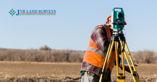
How to Conduct an Accurate Route Survey: Step-by-Step Process
In any infrastructure project - these are roads, pipelines, power lines, or telecommunications networks - accuracy is important in planning. A route survey is the foundation that ensures that the proposed path is possible, efficient and safe. In this initial stage, errors can lead to later delays, cost overrun and design changes. This is the reason why it is necessary to detect the root survey properly for the success of the project.
In this blog, we will break the step-by-step process to conduct an accurate passage survey using a combination of traditional and modern techniques.
What Is a Route Survey?
A route survey is the process of collecting and analyzing geographical data with a proposed corridor for the development of infrastructure. The goal is to define the most suitable path for construction, while the terrain, while accounting for environmental conditions and man -made obstacles.
Examples of where route surveys are used:
Road and highway plan
Railway construction
Pipeline alignment (oil, gas, water)
Strength and telecom line layout
This type of survey usually includes horizontal and vertical alignment, topography, cross-section and sometimes property limitations.
Tools and Technologies in Route Surveying
Modern survey has come a long way from manual measurement. Today, professional equipment and technology rely on:
Total Stations: For measuring distances and angles precisely.
GNSS/GPS Receivers: To obtain accurate geographic coordinates.
Drones (UAVs): Useful for aerial views and 3D terrain modeling.
LIDAR Sensors: For high-resolution elevation and terrain data.
Software Tools: AutoCAD Civil 3D, GIS software, and point cloud tools are used for processing data and creating visual layouts.
These tools help reduce human error and speed up the surveying process while improving precision.
Step-by-Step Process to Conduct a Route Survey
Step 1: Define Scope and Objectives
The first step is understanding the scope of the project-which requires the formation of the area, the size and the end-user requirements.
Consider the following:
Type of infrastructure (road, rail, pipeline)
Start and end locations
Regulatory guidelines
Expected deliverables (maps, digital models, reports)
Being clear objectives will be streamlined by the entire survey process and unnecessary data collection will be avoided.
Step 2: Desktop Study
Before going to the area, study a desktop to review the existing data and maps.
Gather:
Topographic and cadastral maps
Satellite images
GIS layers (forests, rivers, elevation)
Land-use data
This step helps shortlists potential routes and estimate potential challenges, such as preserved land or vertical areas.
Step 3: Field Reconnaissance
Field reconnaissance is an early site trip, also known as "walkover survey". This is a chance to inspect the physical conditions of the route on the ground.
Checklist for field recon:
Note man-made and natural obstacles
Observe slope gradients and soil types
Identify entry points and access roads
Speak with locals or landowners if necessary
This step verifies the beliefs made during the desktop study and prepare the team for full data collection.
Step 4: Establish Control Points
To maintain accuracy throughout the project, you have to install the survey control point. All these are reference points used for measurement and mapping.
Process:
Use GNSS equipment or total stations to fix primary control points
Set secondary points at regular intervals
Record elevation and coordinate data
Mark them physically on the ground using stakes, flags, or paint
These control points ensure that your measurements are aligned with real world coordinates. ,
Step 5: Route Alignment Survey
This route is the main activity in the survey process. This involves collecting detailed topographic and height data along the proposed corridor.
Typical activities include:
Running a centerline through the proposed route
Measuring horizontal and vertical distances
Capturing cross-sections at set intervals (e.g., every 25 meters)
Noting landmarks, vegetation, water bodies, and buildings
Use a combination of total stations, GPS Survey receivers and leveling instruments to collect this data.
Step 6: Use of Drones (Optional but Recommended)
Drone routes are bringing revolution in surveys, especially in hard-to-wheel or large-scale projects.
Benefits of drone surveys:
Fast and efficient data collection
High-resolution aerial imagery
3D terrain modeling using photogrammetry
Safe access to difficult or hazardous terrain
When paired with ground control points, drone can offer centimeter-level accuracy.
Step 7: Data Processing and Mapping
Once the data is collected, it should be processed using special software.
Tools commonly used:
AutoCAD Civil 3D: For creating alignment layouts, profiles, and cross-sections
QGIS or ArcGIS: For spatial analysis and mapping
ReCap or Pix4D: For processing drone imagery
You will convert raw data into usable outputs such as topographic maps, root alignment, profiles and area models.
Step 8: Evaluate Route Alternatives
If many route options are available, compare them based on several factors:
Cost implications
Construction feasibility
Environmental impact
Social and legal constraints
GIS equipment can help score each route and highlight the most practical path. Often, the best route is not the smallest, but the least resistance and cost.
Step 9: Mark Final Alignment
After selecting the optimal passage, the site has time to mark the physically final alignment.
Process:
Place stakes or flags to mark the centerline and key features (e.g., bridge locations)
Paint markers on pavements or trees where applicable
Use GPS to re-verify alignment locations
Inform construction teams of alignment coordinates
The final marking ensures that the passage is clearly defined to designers and contractors.
Step 10: Reporting and Documentation
The final stage is to compile a comprehensive report describing the entire survey process and its findings.
The report should include:
Overview of methods used
Maps and drawings
Control point data
Elevation profiles and cross-sections
Environmental and legal notes
Drone images (if used)
This documentation is essential for engineering team, customers and government regulators.
Challenges in Route Surveying
Even the best survey plan can withstand real -world obstacles. Common challenges include:
Difficult terrain: Hills, rivers, and forests can slow down data collection.
Weather conditions: Rain and fog affect GPS signals and visibility.
Land ownership issues: Trespassing laws or disputes can restrict access.
Data errors: Inconsistent or inaccurate measurements can derail the design process.
To overcome these, always have backup plans, use strong equipment, and double-checked data for stability.
Why Accuracy Matters in Route Surveys
There are long -term benefits of an accurate route survey that affect the entire project life cycle:
Better design decisions: With reliable data, engineers can optimize construction techniques.
Lower construction costs: Fewer surprises during construction mean fewer budget overruns.
Regulatory approvals: Accurate maps and reports help secure permits faster.
Environmental safety: Well-planned routes reduce impact on ecosystems and communities.
1 note
·
View note
Text
Epitome Survey – The Best Drone Survey Company in India
In today’s fast-moving world, Drone Survey technology is shaping industries in ways we never imagined a decade ago. One such groundbreaking advancement is the drone survey—a technique that has redefined how we observe, measure, and map the world around us. Fast, precise, safe, and cost-effective, drone surveys have quickly become the epitome of modern surveying methods, replacing traditional systems with smarter, more efficient solutions.
What is a Drone Survey?
A drone survey uses unmanned aerial vehicles (UAVs) fitted with high-definition cameras, GPS, LiDAR, and other sensors to capture data from above. The drone flies over the target area, collecting hundreds or even thousands of aerial images. These are later processed using photogrammetry software to produce accurate maps, 3D models, topographic data, and more.
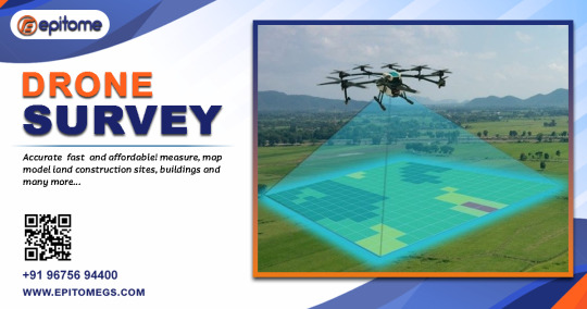
Unlike traditional surveys that require boots on the ground and time-consuming manual measurements, drones provide a bird’s-eye view and deliver results in a fraction of the time.
How Drone Surveys Became the Epitome of Innovation in Mapping
Drone surveys have become the epitome of modern surveying—offering unmatched speed, precision, and safety. From 3D mapping to thermal imaging, explore the key benefits and outputs transforming industries today.
Unmatched Speed and Efficiency Drone surveys can complete large-scale data collection in hours, where traditional methods might take days. Whether it’s a 100-acre farmland or a vast construction site, drones speed up the process significantly, helping teams make quicker decisions.
High Accuracy and Detail Modern drones are equipped with advanced GPS and RTK (Real-Time Kinematic) systems that offer centimeter-level accuracy. Combined with powerful post-processing software, the outputs are not only detailed but also reliable enough for engineering, planning, and environmental studies.
Safe Access to Hazardous Areas Surveying dangerous or hard-to-reach locations like cliffs, rooftops, active construction zones, or disaster-hit areas becomes effortless and safe. Instead of risking human life, drones can capture needed data from above.
Cost-Effective Operations By reducing the manpower, time, and expensive equipment typically needed for surveys, drones lower the overall cost of surveying projects. Also, the ability to detect issues early can prevent costly rework later on.
Versatility Across Industries From agriculture to oil and gas, construction to urban planning, drone surveys offer customized solutions. The same drone can be used to monitor crops, map a city block, inspect a telecom tower, or assess mining stockpiles��just by switching sensors or software.
Key Outputs The Epitome of Smart Drone Surveying
Drone surveys deliver high-precision data that redefine modern mapping. Here are the core outputs:
Orthomosaic Maps – High-resolution, scaled aerial imagery for planning and analysis.
DSM & DTM – Surface and terrain models for engineering and land management.
3D Point Clouds & Models – Accurate representations for design, inspection, and visualization.
Contour Maps – Elevation data for grading, slope, and site planning.
Volume Calculations – Measure stockpiles and earthwork with precision.
Thermal & Multispectral Data – Insights for agriculture, inspection, and environmental studies.
Conclusion:
Drone surveys represent more than just a tech upgrade—they are the very definition of progress in the surveying world. With unmatched speed, safety, accuracy, and adaptability, drones have taken center stage as the most effective way to collect geospatial data.
#epitome#epitomegs#GIS Mapping Survey in India#GIS Mapping Survey#GIS Mapping Company in India#Drone Survey#aerial photography survey#aerial survey
0 notes
Text
Unlocking the Potential of Point Cloud to BIM Services in USA: An Essential in 3D Modeling

In a time when remote collaboration is increasingly becoming a key component of architectural practice, digital tools are revolutionizing how large-scale projects are designed and executed. Point Cloud to BIM services is one of the reliable choices for enhanced accuracy, coordination, and efficiency in dispersed teams. By converting laser-scanned point cloud data into rich Building Information Models (BIM), architects can fully understand existing conditions and design renovation, retrofit, or even new construction work regardless of the location.
What is Point Cloud to BIM Services?
Point Cloud is a collection of data points in three-dimensional space created by 3D scanners, which scan and capture various points on the external surface of an object. The resulting collection of data points captured by the scanner is an accurate as-built of the object and space. Point clouds construct 3D Models or surfaces, which can be utilized for various purposes, including visualization, metrology, quality inspection, animation, rendering, and mass customization.
How are point clouds converted into 3D BIM Models?
The raw point cloud data is converted into a usable BIM model through a structured process. Each step is curated to preserve the accuracy and applicability of the model to the architectural scan to BIM or engineering discipline it intends to serve.
Step 1: Laser Scanning & Data Collection
The process starts with a high-definition laser survey of the physical location or building using any of the two methods- LiDAR or photogrammetry. These instruments record millions of data points in three-dimensional space to produce a point cloud that defines the geometry of the space. The scan can incorporate structural features, mechanical equipment, fixtures, and even furniture based on the level of detail (LOD) needed.
Step 2: Processing Point Cloud Data
Once raw point cloud data is collected, the data is processed further, and prepared for BIM modeling. Multiple scans taken from different points that are not directly aligned undergo Registration - the alignment of individual scans into a single consistent point cloud.
There can be noise in the point data from transient objects like people moving through the scene, cars, or irrelevant environmental subtleties. Therefore, point clouds are filtered, and extraneous points are omitted using software tools designed to improve the usability and clarity of the point cloud for 3D BIM modeling.
Step 3: Point Cloud Conversion Services
Skilled technicians convert the cleaned point cloud data and begin modeling individual elements into a BIM context. Structural components (beams, walls, columns), architectural components (doors, windows, finishes), and MEP systems (ductwork, piping, electrical systems) are modeled as per the project requirement.
Accuracy and standard compliance are necessary for a smooth workflow. Remote architects typically communicate with modeling teams through common platforms such as BIM 360 or Trimble Connect to verify progress and provide feedback.
Step 4: BIM Model Creation & Validation
This stage involves converting 3D point cloud data into BIM objects, either manually, half-automatically, or automatically, depending on the software and the level of detail (LOD). BIM technicians typically refer to the point cloud to delineate the elements, including the walls, floors, doors, windows, beams, columns, and MEP items.
Simple forms such as straight lines or round pipes are recognized by half-automated instruments, but manual selection ensures accuracy. The level of modeling depends on the LOD, ranging from basic geometry (LOD 200) to very detailed, fabrication-level models (LOD 400–500).
Step 5: Delivering the Final BIM Model
After validation, the final model is packaged and delivered as per the project deliverables. Deliverables may include native BIM files (.rvt,.ifc), federated models for coordination, 2D documentation extracted from the BIM model, and asset data for facilities management. The delivery process typically includes a knowledge transfer session so that all stakeholders can navigate and use the model efficiently for downstream processes like design development, construction planning, or facilities operations.
Success Story : 400,000 Sq.Ft. of Scan to BIM Conversion in Just 43 Days
Advantages of Point Cloud to BIM Modelling Services
Point Cloud to BIM modeling is necessary for making data-driven construction feasible in case of large, complex, tight-tolerance, or complicated geometry projects with mixed-use programming. The model provides real-time insights that inform design choices, regulatory compliance, and stakeholder communication, as well as ease downstream processes like cost estimating, procurement, and scheduling. Let’s look at the benefits in detail:
Improved Accuracy & Precision
The primary advantage of Point Cloud to BIM modeling services is that they can replicate real conditions to a millimeter level of accuracy. This precision avoids guesswork in design and reduces the likelihood of costly rework in downstream stages.
Cost & Time Efficiency
With fewer site visits and the use of high-fidelity scans, remote architects can substantially reduce travel costs and project timelines. Moreover, automated workflows and cloud collaboration facilitate decision-making and documentation.
Enhanced Design & Planning
Point cloud BIM models enable strong spatial analysis and design-informed interventions. Whether introducing new systems into an existing building or designing adaptive reuse, the model offers a reliable digital twin for design thinking.
Seamless Collaboration
The designing team, architects, contractors, and users can work effectively with the 3D model created from point-cloud images. Since the team can see the new design concurrently, it is simple to identify any bug or pitfall in the new design. The required updates can be proposed and discussed more easily and effectively. The structural, architectural, and MEPF Scan to BIM Services staff can create their own opinion, introduce the concepts and proposals to eliminate any potential risk, and design issues, and develop a sustainable and efficient design.
Restoration & Renovation
The Scan to BIM tool is widely utilized for the refurbishment or renovation of existing or old structures. Utilizing the scanned images, the 3D model of the structure with details of the structure, MEP systems, etc, is created. A preliminary impression of the existing structure helps in designing and analyzing a new structure for the project. The as-built model that is derived from Scan to BIM services has the advantage of comparing the new design and its parameters with the existing design. This as-built model is more accurate than the information acquired through manual surveying.
Enhancing Point Cloud to BIM Modeling Services with AI
As sustainability becomes a global mandate, accurate as-built models facilitate more precise energy simulation, life cycle analysis, and performance monitoring—making them imperative in forward-looking construction practices. With AI-powered Point Cloud to BIM modeling services in the USA offered by Scan To Bim.online, the AEC firms can leverage lightning-fast conversion speed and minimize human intervention. The tool guarantees 50% faster speed than any other tool, ensuring tailored and timely project deliveries.
Conclusion
As the construction and architecture industry becomes more used to hybrid and remote work patterns, tools like Point Cloud to BIM services in the USA bridge the gap between physical environments and computational design processes. For architects managing far-flung projects of greater scale, the AI-powered services offer a reliable platform to ensure efficient, reliable, and collaborative project delivery.
#Point Cloud to BIM services#Point Cloud to BIM services USA#Scan to BIM Services#architectural scan to BIM#MEPF Scan to BIM Services
0 notes
Text
The Advancements and Importance of 3D Land Surveying
For many years, land surveying has been a crucial part of engineering, land development, and building. Traditional 2D procedures are quickly being superseded by more accurate and effective techniques as a result of technological advancements. 3D land surveying is among this field's most groundbreaking innovations. Professionals in a variety of industries may make well-informed judgments thanks to this contemporary surveying technique, which provides a thorough, precise, and three-dimensional depiction of the landscape.
3D Land Surveying: What Is It?
In order to gather comprehensive spatial data about the earth's surface, it uses cutting-edge instruments and technologies like laser scanners, GPS, drones, and LiDAR (Light Detection and Ranging). In order to extract measurements, contours, and other geographical information, the gathered data is then processed into a digital 3D model called a point cloud, which may be examined and altered in software settings.
3D Land Surveying provides a dynamic and extremely detailed representation of terrain elements, such as elevations, slopes, and structural layouts, in contrast to traditional surveying, which depends on manual equipment and flat representations. This lowers the time and effort required for fieldwork while also increasing accuracy.
Uses for Three-D Land Surveying
Because of its adaptability, this is beneficial in a variety of industries:
Civil engineering and construction: 3D models are used by architects and engineers for site planning, design verification, and progress monitoring. It reduces expensive alterations and delays by spotting any problems before construction starts.
Urban Planning and Development: With 3D data, urban planners may more effectively plan transportation systems, evaluate the effects on the environment, and simulate infrastructure layouts.
Mining and Quarrying: To track excavation progress, compute volumes, and make sure safety regulations are followed throughout mining operations, surveyors utilize 3D models.
In agriculture and forestry: 3D surveying helps with crop analysis, planning irrigation, and managing forests, all of which increase productivity and sustainability.
3D Land Surveying Advantages
Accuracy is one of the key benefits of 3D land surveying. In just a few minutes, it can gather millions of data points and produce intricate models with little error. Furthermore, surveyor hazards are decreased by the safe access to dangerous or difficult-to-reach locations made possible by the use of UAVs and remote sensors.
Furthermore, efficiency is greatly increased by 3D surveying. Today, tasks that used to take days or weeks can be finished in a fraction of the time. Cloud-based solutions also make it simpler for teams to interact and exchange data.
Conclusion
The way we engage with the real world has advanced significantly with 3D land surveying. In addition to improving data gathering speed and accuracy, it offers deep, useful insights that are advantageous to a variety of sectors. 3D surveying will probably become the norm as technology develops further, expanding the realm of what is feasible in terms of land management and measurement. The future of mapping analysis is being transformed by these surveying, a potent tool for professionals looking for accuracy, security, and efficiency.
For More Inquiry: Contact Us
0 notes