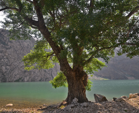
#mountain gorge dam
Text
Shanghai Cooperation Organization(上海協力機構)
An international organization made up of demon nations.
Of course, the headquarters are in Shanghai.
There is a mountain gorge dam upstream of it.
Babylman
2 notes
·
View notes
Text


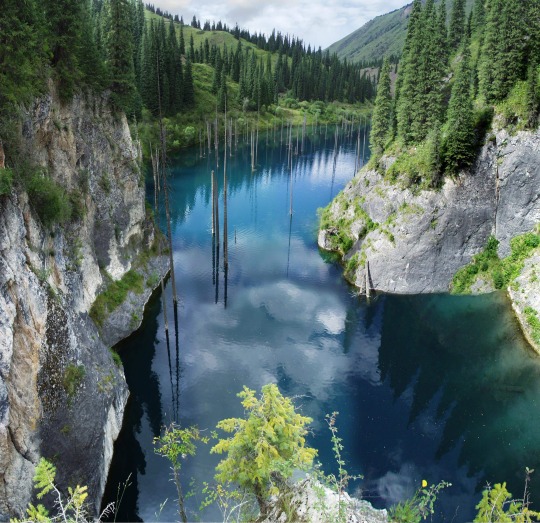


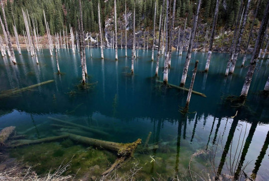
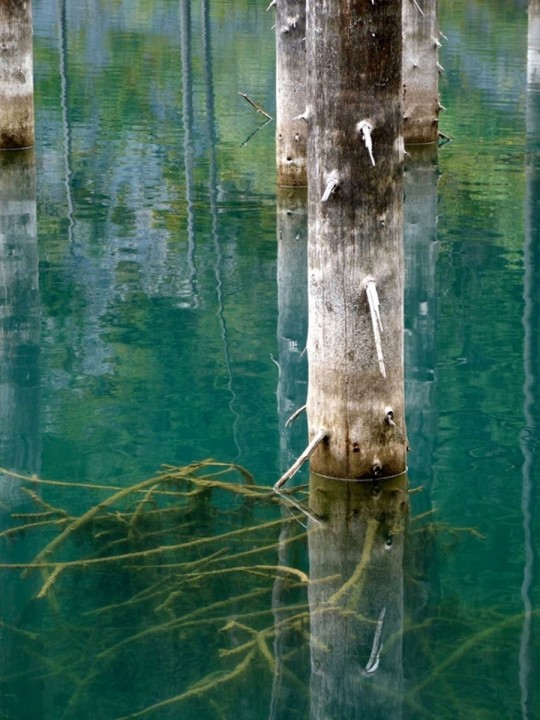


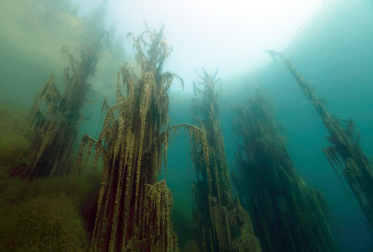

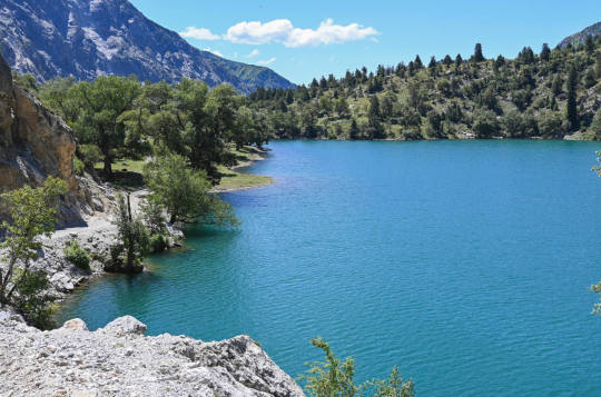
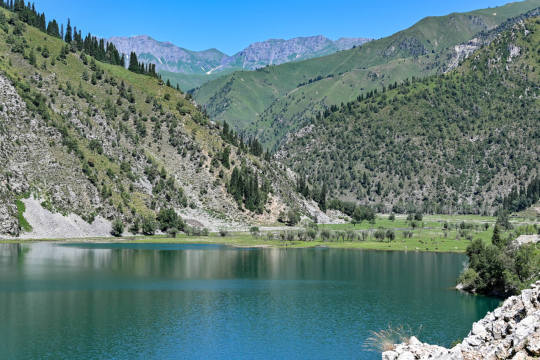
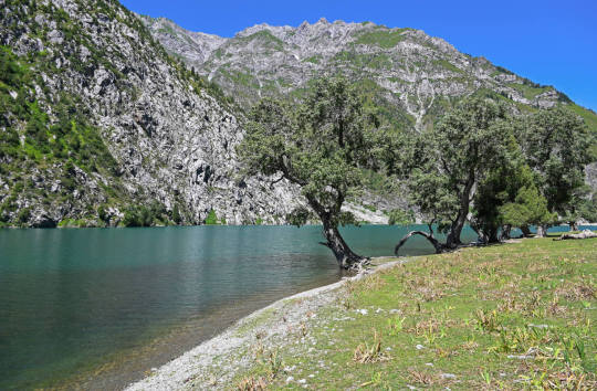
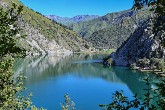
Каинды - 400 метровое озеро в Казахстане, в долине Тянь-Шаня, в 129 км от города Алматы. Оно расположено среди хвойного леса на высоте 1667 метров над уровнем моря. Озеро Каинды образовалось после землетрясения 1911 года, которое вызвало большой оползень, заблокировавший одно из ущелий горного хребта Кунгей Алатау, образовав естественную плотину. Впоследствии, дождевая вода заполнила долину и наполнила озеро.
Озеро славится своей красотой подводного леса. Макушки самых высоких деревьев поднимаются прямо из воды. Средняя глубина составляет 20 метров, а в некоторых местах доходит до 30 метров. Вода в озере настолько холодная (даже летом температура воды не превышает 6 градусов), что могучие сосны по-прежнему остаются полузамороженными на своих местах, даже 100 лет спустя. Благодаря чистой горной воде, можно увидеть глубины озера. Вода в озере пресная, практически не содержит растворенных солей и идентична той воде, которая подвергается многоуровневой очистке в лаборатории.Зимой поверхность озера замерзает и становится прекрасным местом для ловли форели и подлёдного дайвинга.
Этот природный объект внесён в список особо охраняемых природных территорий со статусом природоохранного и научного учреждения, а также входит в Государственный национальный природный парк "Кольсайские озёра".
Kaindy is a 400-meter lake in Kazakhstan, in the Tien Shan Valley, 129 km from the city of Almaty. It is located among a coniferous forest at an altitude of 1667 meters above sea level. Kaindy Lake was formed after the earthquake of 1911, which caused a large landslide that blocked one of the gorges of the Kungei Alatau mountain range, forming a natural dam. Subsequently, rainwater filled the valley and filled the lake.
The lake is famous for its underwater forest beauty. The tops of the tallest trees rise straight out of the water. The average depth is 20 meters, and in some places it reaches up to 30 meters. The water in the lake is so cold (even in summer the water temperature does not exceed 6 degrees) that the mighty pines still remain semi-frozen in their places, even 100 years later. Thanks to the clear mountain water, you can see the depths of the lake. The water in the lake is fresh, contains practically no dissolved salts and is identical to the water that is subjected to multi-level purification in the laboratory.In winter, the surface of the lake freezes and becomes a great place for trout fishing and ice diving.
This natural object is included in the list of specially protected natural territories with the status of an environmental and scientific institution, and is also included in the Kolsai Lakes State National Natural Park.
Источник://discoverynn.ru/blog/kazakhstan/ozero-kaindy-neobychnaya-dostoprimechatelnost-na-yuge-kazakhstana/ , ://newtimes.kz/obshchestvo/155196-podvodnyj-les-ozera-kaindy-udivil-kazahstancev,//tourlenta.com/blog/316-podvodnij-les-na-ozere-kaindi,m.vk.com/wall-222521402_9950,//www.stena.ee /blog /zatoplennyj-les-odno-iz-samyh-krasivyh-mest-kazahstana,//dzen.ru /a/ZOZQ8LxcWxUAPkQe,aveneerdmc.com/ru/inspiration/kaindy.
#Kazakhstan#Kaindy#nature#nature aesthetic#landscape photography#mountains#trees and forest#lake#blue sky#travel#wonderful#nature video#nature photography#underwater photos#Казахстан#Каинды#природа#Пейзаж#горы#лес#озеро#небо#туризм#видео природы#природнаякрасота#подводные фото
195 notes
·
View notes
Text
Uncovering the unreleased Far Cry 5 in-game Encyclopedia
The almost complete but unused in-game encyclopedia, reconstructed thanks to the oasisstrings file.
Please note that it’s still cut content, so some information might not be relevant anymore.
You can read the oasisstrings file here. Pictures from this encyclopedia were also extracted and posted by @xbaebsae here.
Part 3: Locations - Whitetail Mountains
PIN-K0 Radar Station
Part of the Pine Line early warning system, the K0 facility was shuttered in the early 90's and left to the elements.
Rattlesnake Trail Bridge
A footbridge along the Makwa Trail, it connects one side of the gorge to the other, like bridges are supposed to do.
Snowshoe Lake
A clear glacial lake high up in the Whitetail Mountains. The water is always near freezing which makes skinny dipping a terrible idea.
Hunter’s Pass Shelter
A remote cabin used as a place to warm up or stay the night by hunters.
Ozhigwan Falls
One of the highest in the area, Ozhigwan falls is one of the natural wonders of the Park.... just don't step too close.
Jefferson Lookout Tower
A watch tower in the middle of the forest, meant to keep an eye out for forest fires or bears... or bears on fire.
Whitetail Park Visitor Center
It's where you'd go to find out what's going on at Whitetail Park, back when it was operational.
Hawkeye Tunnel
A tunnel through the mountain that offers a bird's eye view of the valley below.
Whitetail Park Ranger Station
The Ranger Station that patrols the Whitetail Park to keep it safe back when it was still open.
McKinley Dam
Named after the 25th president of the United States, McKinley Dam is used to regulate water and supply power to the people of Hope County.
Jacob’s Armory
Jacob has converted part of the McKinley Dam power station to be used as sanctuary against the coming apocalypse.
Grand View Hotel
The historic hotel in the Whitetail Mountains it was once the crown jewel of the park. Financial problems shut it down in the 80's. It's been empty ever since.
North Park Entrance
The Northern most entrance to Whitetail Park, abandoned now that the park is closed.
Bo’s Cave
A renown survivalist, Bo lives deep in forest. He is completely off the grid with none of the comforts of modern life.
Cooper Cabin
Another cabin that can be rented at Whitetail Park. Lately has been used as a safe-house by the Whitetail Militia.
Red Tail Cabin
A cabin in Whitetail Park that Eli's Militia use to take refuge from the constant attacks from Jacob's patrols.
F.A.N.G. Center
Friends of the Animals Nursing Grounds is home to Cheeseburger the Bear. Feeding times are 12:00 and 6:00 daily.
St. Francis Veteran's Center
A medical center for returning veterans, St. Francis was shuttered in the 90's when a more modern facility was constructed in a nearby county. When Eden's Gate moved in, Jacob found use for it as a place to indoctrinate his new recruits.
Lansdowne Airstrip
A small airstrip used by the locals for shipping in supplies and sightseeing tours.
Elliot Residence
Home to Rick Elliot and his family, one of the last people to holdout against Jacob and his army.
The Grill Streak
When Chad's diner was burned to the ground he retreated to his food truck. He still works hard to find food for Eli and his Militia.
Breakthrough Camp
A camp where parents sent their rebellious youth in order to get a taste of clean, wholesome outdoor living.
Old Sun Outfitters
The main supply store for camping and survival gear in the area. Seeing the writing on the wall, the owners closed shop and left while they still could.
Baron Lumber Mill
The Baron family lumber mill was already failing financially when Eden's Gate moved in and bought it out.
McNeill Residence
This house once belonged to the McNeill family before they were deemed sinners in the eyes of the cult and were forced to flee.
Linero Building Supplies
A small building supply store that sold lumber and materials. The owners ended up joining Eden's Gate, though not all of them willingly.
Haskell Lookout Tower
A watch tower overlooking the north region of the Whitetail Park.
Fort Drubman
Pretty much all the Hurk Sr. has left after his divorce from Adelaide. It's from here he runs his senate campaign with the dubious help of his son, Hurk Jr.
MCA Mobile Lab
A mobile lab where the Montana Conservation Authority conducts research on the local flora and fauna.
Loresca Residence
Former residence of Jay Loresca, former Navy Seal. Rumor has it he joined the Whitetails, but it's certain that he’s long gone.
Whitetail Mountains Rail Bridge
A bridge connecting the Henbane River and the Whitetail Mountains. It's been out of use ever since the Copperhead Rail stopped running.
Elk Jaw Lodge
Part of the Whitetail Park the Elk Jaw Lodge was a nice place to relax near Silver Lake. Now... not so much.
Wolf’s Den
The secret bunker of the Whitetail Militia, home to Eli, their leader, as well as Tammy and Wheaty.
Oberlin Picnic Area
A nice place for a group to sit down, eat, and take in baseball game at the nearby diamond.
Osprey Cabin
One of the many cabins that visitors can rent at Whitetail Park. Named after birds of prey, thy are the perfect hiding places for Eli's Militia.
Kestrel Cabin
One of the handful of individual cabins available to rent at Whitetail Park.
Mansfield Lookout Tower
An abandoned fire watch tower overlooking the southern region of Whitetail Park.
Frank’s Cabin
A cabin owned by a recluse known as Lonely Frank. He seems to like it that way.
Dansky Cabin
This is where Dicky Dansky comes to write his books about Sasquatches, Bigfoot, and other cryptids.
Valley View Overlook
A place for visitors to stop and take in the view of the forest below.
Stone Ridge Chalet
High up on a rocky ridge is a Chalet where hunters and park visitors could come and warm up.
Silver Lake Parking Lot
A nice place to stop and take a refreshing dip in nearby Silver Lake.
Clagett Boathouse
A boathouse and docks maintained by the Old Sun Outfitters.
Salvage Camp
A small camp where a salvage company is attempting to recover items from the wreck of a sunken plane
Dylan’s Master Bait Shop
In case you needed some fishing pointers... Dylan will likely just point you somewhere else.
Langford Falls Parking Lot
A spot for visitors to pause and take in the beauty of the nearby Langford Falls.
Widow’s Creek
One of Skylar's favorite fishing spots. She'll probably tell you where it got its name.
Fowler’s Retreat
A not-so-secret place where Dave keeps all of his extra Cheeseburger merchandise.
South Park Entrance
The southern enterance to Whitetail Park. Once the gem of Hope County, it has seen better days.
#far cry 5#hope county#whitetail mountains#jacob seed#bo adams#cheeseburger#chad wolanski#hurk drubman jr#hurk drubman sr#eli palmer#tammy barnes#wheaty#dylan#skylar kohrs#dave fowler
36 notes
·
View notes
Text
INTERVIEW
Cyrus Cornut, On the Four Shores of Passing Times

Cyrus Cornut, On the Four Shores of Passing Times, Chongqing, People's Republic of China, 2008.
Known as the «Mountain City,» Chongqing sits at the confluence of the Yangtze and Jialang Rivers, its skyline often obscured by the perpetual fog that envelops it. A city of contrasts, Chongqing is both the heir to displaced communities from the Three Gorges dam and a testament to the rapid modernization efforts of the Beijing authorities, who have elevated it to the status of a municipality.
Against this backdrop of relentless development, Cyrus Cornut's lens captures the essence of Chongqing's urban landscape. From the gravity-defying skyscrapers that dot the skyline to the bustling streets teeming with newcomers, each photograph reveals a city in constant motion.
See more here → allcitiesarebeautiful.com
#allcitiesarebeautiful#photography#photographers on tumblr#new topographics#alteredlandscape#builtenvironment#photographicresearch#vernacular architecture#chongqing#china#architecture#landscape#cityscape#metropolis
4 notes
·
View notes
Text
Music For the Soul
by Alexander MacLaren

Fleeing and Clinging
"We… who have fled for refuge to lay hold of the hope set before us."
— Hebrews 6:18
The writer blends two vivid metaphors here, the one of a fugitive unsheltered in the open, surrounded by foes; the other of a man grasping some strong stay. Look at the two pictures. " Fled for refuge." The scene brought before us is that of a man flying for his life, with the pursuer clattering at his heels, and his lance-point within a yard of the fugitive’s back. Grass will not grow under that man’s feet; he will not stop to look at the flower by the road. The wealth of South Africa, if it were spread before him, would not check his headlong flight. It is a race for life. If he gets to the open gate he is safe. If he is overtaken before he reaches it, he is a dead man. The moment he gets within the portal the majesty of law compasses him about, and delivers him from the wild justice of revenge. " By-and-bye" kills its tens of thousands. For one man that says, "I am not a Christian, and, what is more, I never intend to be," there are a dozen that say, " To-morrow! tomorrow! " " Let me sow my wild oats as a young man; let me alone for a little while. I am busy at present; when I have a convenient season I will send for thee." What would have become of the man-slayer if he had curled himself up in his cloak, and laid down beside his victim, and said, " I am too tired to run for it"? He would have been dead before morning. A rabbi’s scholar, as the Jewish traditions tell us, once said to him, "Master! when shall I repent?" "The day before you die," said the Rabbii. The scholar said, " I may die to-day." Then said the Rabbi, "Repent to-day." "Choose you this day "whether you will stand unsheltered out there, exposed to the pelting hustling of the pitiless storm, or will flee to the Refuge and be saved.
Look at the other picture: "to lay hold of the hope." Perhaps the allusion is to the old institution of Sanctuary, which perhaps existed in Israel, and at any rate was well known in ancient times. When a man grasped the horns of the altar he was safe. If so, the two metaphors may really blend into one: the flight first, and then the clutching to that which, so long as the twining fingers could encompass it, would permit no foe to strike the fugitive. This metaphor speaks of the fixity of the hold with which we should grasp Jesus Christ by our faith. The shipwrecked sailor up in the rigging, with the wild sea around him, and the vessel thumping upon the sand, will hold on, with frozen fingers, for hours, to the shrouds, knowing that if he slips his grasp the next hungry wave will sweep him away and devour him. And so you should cling to Jesus Christ with the consciousness of danger and helplessness, with the tight grasp of despair, with the tight grasp of certain hope.
I remember reading of an inundation in India, when a dam, away up in a mountain gorge, burst at midnight. Mounted messengers were sent down the glen to gallop as hard as they could and rouse the sleeping villagers. Those who rose and fled in an instant were in time to reach the high ground, as they saw the tawny flood coming swirling down the gorge, laden with the wrecks of happy homes and many a corpse. Those who hesitated and dawdled were swept away by it.
9 notes
·
View notes
Text
9th October 1963 - The Vajont Dam disaster
The dam of the Vajont river, straddling over the italian regions of Friuli-Venezia Giulia and Veneto, is one of the tallest dams in the world standing at 262m of height. It was initially conceived in the '20s but eventually built only much later from 1957 to 1960 against the will of the communities below and the opinions of many geologists.
The Vajont Dam in 1960.
The deep gorge of the Vajont river is in fact a known geologically unstable area with a long history of landslides and sorrounded by mountains with poor structural integrity. Despite all the warnings and repeated signs of instability and after many unfavorable forecasts based on simulations, the dam's basin was filled beyond security level.
In the night of 9th October 1963 a ginormous landslide 2km wide made of 260 millions m3 of rocks and dirt fell from Mount Toc speeding down at over 100km/h.
Almost the entire side of the mountain came down to completely fill the basin, generating a seismic shock and a megatsunami. A wave 250m tall leapt over the dam and 50 millions m3 of water rushed into the valley below devasting everything in its path with a display of energy equatable to twice the nuclear blast of Hiroshima and originating an impact crater 60m deep and 80m wide.
The dam and its basin after the landslide.
The towns of Longarone, Pirago, Rivalta, Villanova and Faè, in the Piave Valley below, were totally obliterated.
Almost 2000 people were killed, many of them have never been identified. And 1300 more have never been found.
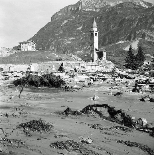

The towns of Pirago and Longarone after the disaster.
The dam's site manager, engineer Mario Pancini, overcome by guilt took his own life two months later. After much debate over the predictability of the tragedy only two people, project engineer Alberico Biadene and Francesco Sensidoni of the Department of Public Works, were found guilty and sentenced, respectively, to 5 years and 3 years and 8 months in prison.
In 2000 Montedison (who in the meantime had acquired electric society SADE, owner of the dam), ENEL (italian multinational and public manufacturer and distributor of electricity and gas), and the Italian State were ordered to jointly compensate the town of Longarone for 55.645.758.500 lire (about 28 millions euros).
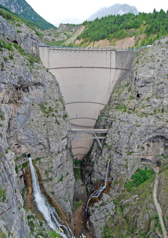
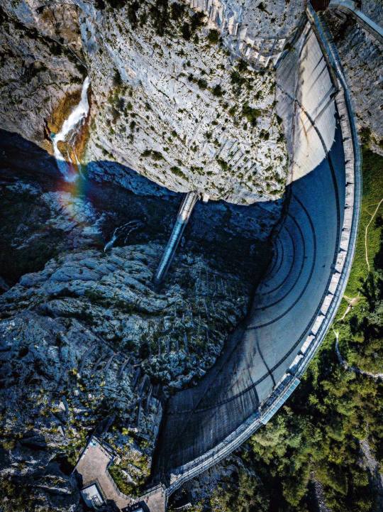
The Vajont Dam today
The Vajont Dam disaster was declared by the UN one of the worst man-made disasters in history.
What's really flabbergasting is that the dam survived the catastrophe almost completely unscated and it's still considered today a masterpiece of engineering.
A masterpiece built in the wrong place and a perennial warning against human kind's greed and delusion of omnipotence.
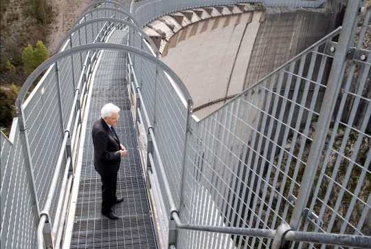
President Mattarella on the dam's walkway in occasion of the tragedy's 60th anniversary (9th October 2023).
#as president mattarella said human kind's part of nature#we must stop trying to control it#vajont#disastro del vajont#vajont dam disaster#remember#vajont 60 anni#longarone#pirago#rivalta#villanova#faè#man-made disasters#italy#dam
5 notes
·
View notes
Note
Hi there :D
7, 13 and 28 for the "not from the US" ask game? if you don't mind, naturally <3
Hiii, thanks for the ask <3
And sorry it took me so long to answer🙈
7.) Three words from your native language you love the most.
At first I was like, this question is going to be so easy. But when I started answering it, I was like... shit. This is HARD. Because, the thing is where I'm from, you grow up borrowing words from the other 10+ languages sprinkled through out the country and after a while you forget which are actually part of your language. So, I'm going to cheat a little bit. I'm going to do 3 in my Native language (Afrikaans) and 3 that I love using that aren't part of it. So, in no particular order i present to you:
Native language (Afrikaans):
• Sonbesie. Literally/directly translates to sun beetle. I don't know why but I love this word so much.
• Spookasem. Directly translates to ghostbreath. It actually means candyfloss though. I love how it sounds so spooky in Afrikaans but it sounds so... cute in English.
• Nou-nou. It's Afrikaans for now-now. Why I love this word so much is that it doesn't necessarily mean now, it could be any time from between 5 minutes to a year. You don't know how long nou-nou is. You'll find out. Eventually.
Other languages:
• Thula. It means 'be quiet'. There's a lullaby called 'thula baba' that I grew up hearing and thula's been one of my favorite words ever since.
• Tokoloshe. A Tokoloshe is a dwarf-like water spirit that is mischievous/evil. I love the sh and t sounds of the word.
• Shongololo. In plain English, a millipede. I love the sound and look of the word. It looks like a shongololo.
13.) Does your country (or family) have any specific superstitions or traditions that might seem strange to outsiders?
▪︎Kakelaars, a type of bird with a long tail and a red beak, (it's less commonly know as a green wood hoopoe in the part of the country where I'm from) are said to call the rain when they cackle. So far, the kakelaars that live in the trees across from us has never been wrong.
▪︎ Just before you enter Schoemanskloof, you'll see a statue that's probably painted in one way or another. That isn't a statue. That's a rock. And his name is Old Joe.
So far, Old Joe has been painted to look like a cat, the Virgin Mary, a soccer player and a Christmas minion to name a few. Most of the art work is done by an artist known as Ghost and every few months he'll give Old Joe a new appearance. It's almost become something of a tradition.
Also! It's believed that if you honk/wave at Old Joe as you drive by you'll have a safe journey through the gorge.
(If anyone wants to hear more about Old Joe/ see pictures please feel free to ask!)
▪︎ The clouds that can regularly be seen floating over Devil's Peak and Table Mountain aren't just clouds according to a local legend. They are actually clouds of smoke drifting across the peak/mountains due to a smoking match going on between a sea captain and the Devil up on the peak (it's also how Devil's Peak got its name.)
(If you want to hear more, let me know! I'm kind of embarrassingly into South African myths, legends and superstitions. It's a new obsession tbh😅)
There's a lot more but I don't want to bore anyone so I'm just going to stop here😂
28.) Does your country have a lot of lakes, mountains, rivers? Do you have favorites?
We do! More dams than lakes but we have both. Oceans and forests too! My favorite? The mountains (and the forests, they're usually together.) Especially the Drakensberg mountains. They. Are. Beautiful. They also have cave art that is several thousands of years old. The hiking trails are also fun, especially when you reach the top, or find a hidden away river. Ohh, and ziplining! I love the actual ziplining and the hike back to the top. And the picturesque-ness of it all...
Yep, definitely the mountains.
Thank you so much for the ask <3
(If there are anymore questions, please ask, I love asks)
And because I took so long, here'a picture of Old Joe as a speed cop (credit goes to the og photographer) -

2 notes
·
View notes
Text
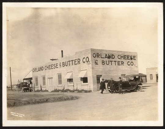
Happy National Cheese Lovers Day to all who celebrate
Below is a c. 1915 photo of the Orland Cheese and Butter factory in Orland, California. The image shows a creamery operated by the farmers of The Orland Project, which transformed the area’s soil.
What was The Orland Project? Expand for more details:
The Orland Project, in north-central California, is located about 100 miles north of Sacramento. The project incorporates parts of neighboring Glenn, Tehama and Colusa counties. The hub of the project, the town of Orland, is in northern Glenn County.
One of the smallest projects ever tackled by Reclamation, the project irrigates 1 percent of the Sacramento Valley’s total irrigable soil, 20,000 acres. The project, one of the oldest federal reclamation projects in the country and one of the first undertaken in California, was authorized by the Secretary of the Interior in October 1907 after a finding of feasibility by a board of engineers.
Water was delivered to the first farm units at the beginning of the 1910 growing season. The project is irrigated by Stony Creek, a tributary of the Sacramento River. Flowing northward, the creek gathers water drained from the surrounding slopes of the Coast Range Mountains. The collected water irrigates lands on both sides of the creek near the town of Orland.
The Orland Project comprises two main dams to store water, East Park and Stony Gorge, two diversion dams, almost 17 miles of canals, and 139 miles of laterals. Orland has some of the best conditions for agriculture. The growing season lingers over 262 days from March to November. The project’s soil is considered some of the richest and most productive in the nation. Orland, and the Sacramento Valley, is warmed by a thermal belt, with very few frosts. Average rainfall is 17.99 inches, most of which is measured between the first of November and the first of April. With hardly any snow, winter runoff occurs almost immediately after precipitation. The project has an average annual runoff of 410,000 acre feet.
[Description from usbr.gov]
#orland#orland california#california history#the orland project#dams#farming#irrigation#history#historic image#cheese#cheese lovers day#dairy#creamery#california cows
8 notes
·
View notes
Text


When looking for spots to visit for a brief Memorial Day weekend trip, Tallulah Gorge was at the top of my list. Located near the border of Georgia and South Carolina, the park is around an hour away from Interstate 85 and a suitable halfway point on my drive from coastal Mississippi to northwestern North Carolina, ideal for visiting family in the Carolinas.
It seems like I have an unconscious desire to visit every canyon and river gorge in the Southeastern United States and Tallulah Gorge is a worthy addition among the other places I have visited. A state park offers public access to the most dramatic vantage points of the canyon and if you are real ambitious you can try to be one of the lucky 100 to obtain a permit to hike the gorge floor. Though there are many longer gorge systems in the Eastern United States, Tallulah Gorge has to be one of the steepest on the list. A descent into the gorge would be rather dangerous were it not for the suspension bridge and many, many stairs.
A dam was completed in the area in 1913 and is located just above the gorge. The dam is one of several along the Tallulah River. One must imagine how much raw power the river possessed prior to the dam's creation as it spilled through the narrow mountain passage. The park is a little over 97 miles from Atlanta as well, so don't harbor any illusions about having the park to yourself. Since I was there on a memorial day weekend the park was jam packed, but the park is large enough that you can find a measure of solitude once you get away from the suspension bridge.
It is labeled as one of Georgia's seven natural wonders and for good reason. The gorge was my reason for going to this stretch of Georgia and it did not disappoint and I would advise anyone who is making a journey down Interstate 85 to take a brief detour and see it for yourself.
0 notes
Text
Cracking the Code: A Simplified Guide to a China Visa for UAE Residents
The allure of China, with its Great Wall snaking across mountains and bustling night markets overflowing with exotic delicacies, is undeniable. If you're a UAE resident yearning to explore this land of contrasts, a China Visa for UAE Residents is your key. But the application process can feel like deciphering ancient Chinese characters. Fear not, intrepid traveler! This guide sheds light on the process, making it a smooth journey.
Why Apply for a China Visa for UAE Residents?
China offers a captivating blend of ancient and modern. Imagine wandering through the Forbidden City's majestic halls, marveling at the engineering marvel of the Three Gorges Dam, or getting lost in the futuristic megacity of Shanghai. A China Visa for UAE Residents unlocks this treasure trove, allowing you to explore historical sites, indulge in culinary delights, and experience the unique charm of China.
Tailoring Your China Visa for UAE Residents
China offers a variety of visa categories to cater to your specific needs. Here's a decoder ring to help you identify the perfect fit:
Tourist Delights: The Tourist Visa (L Visa) is your companion for leisure trips, sightseeing adventures, or visiting family and friends.
Business Ventures: The Business Visa (M Visa) facilitates business meetings, conferences, or exploring potential business partnerships.
Short Stopover: Depending on your nationality and layover duration, a Transit Visa (G Visa) might be required.
Cracking the Code: The China Visa for UAE Residents Application
With your visa category chosen, let's embark on the application odyssey. Here's a breakdown of the key steps:
Online Application: The Chinese consulate or visa application service center (VAC) website is your starting point. Here, you'll embark on a virtual journey by filling out an online application form, detailing your travel plans, personal information, and employment status.
Document Preparation: Assemble the required documents based on your chosen visa category. This typically includes your passport, valid UAE residence visa (ensure it meets validity requirements), proof of sufficient funds, travel itinerary, and an invitation letter if visiting a business entity or individual in China.
Biometric Verification: Schedule an appointment at a designated VAC in Dubai. During this visit, you'll provide your fingerprints and a digital photograph.
Visa Fee Payment: Pay the associated visa fees securely online or at the VAC during your appointment.
Insider Tips for a Streamlined China Visa for UAE Residents Application
Plan Ahead: Processing times can vary. Apply for your China Visa for UAE Residents at least 4-6 weeks before your intended travel date to avoid any last-minute delays.
Documentation Scrutiny: Double-check everything! Ensure all documents are complete, valid, and translated into English or Mandarin Chinese if necessary.
Proof of Funds: Demonstrate sufficient financial resources to cover your stay in China through bank statements or other relevant documents.
Travel Insurance: While not mandatory, travel insurance provides valuable protection against unforeseen circumstances during your visit.
Unlocking the Wonders: Your China Adventure Begins
With your China Visa for UAE Residents secured, the door to adventure swings open! Explore China's rich history, breathtaking landscapes, and vibrant culture. So, pack your bags, embrace the unknown, and embark on your unforgettable Chinese odyssey!
Choosing Your Path: Tailoring Your China Visa for UAE Residents
China offers a variety of visa categories to cater to your specific travel goals. Here's your compass to help you choose the perfect one:
Tourist Trailblazer: The Tourist Visa (L Visa) is your trusty companion for leisure trips, sightseeing adventures, or visiting loved ones.
Business Voyager: The Business Visa (M Visa) facilitates business meetings, conferences, or exploring potential partnerships, allowing you to conquer the Chinese market.
Quick Stopover: Depending on your nationality and layover duration, a Transit Visa (G Visa) might be required.
Conquering the Application Process: Your China Visa for UAE Residents Awaits
With your visa category chosen, let's embark on the application journey. Here's a roadmap to guide you:
Digital Voyage: Launch Your Online Application: The Chinese consulate or visa application service center (VAC) website is your launchpad. Here, you'll embark on a virtual journey by filling out an online application form, detailing your travel plans, personal information, and employment status.
Document Arsenal: Gather Your Supporting Documents: Assemble the required documents based on your chosen visa category. This typically includes your passport (ensure it has sufficient validity), valid UAE residence visa, proof of sufficient funds, travel itinerary, and an invitation letter if visiting a business entity or individual in China.
Biometric Verification: Schedule an appointment at a designated VAC in Dubai. During this visit, you'll undergo biometric verification, providing your fingerprints and a digital photograph.
Visa Fee Payment: Pay the associated visa fees securely online or at the VAC during your appointment.
Insider Tips for a Smooth China Visa for UAE Residents Application
Plan for the Journey: Processing times can vary. Apply for your China Visa for UAE Residents at least 4-6 weeks before your intended travel date to avoid any last-minute roadblocks.
Scrutinize Your Documents: Double-check everything! Ensure all documents are complete, valid, and translated into English or Mandarin Chinese if necessary. Don't leave anything to chance!
Proof of Funds Offensive: Demonstrate your financial capabilities by providing bank statements or other documents showcasing sufficient funds for your stay in China.
Travel Insurance Shield: While not mandatory, travel insurance provides a protective shield against unforeseen medical emergencies or travel disruptions.
0 notes
Text
Озеро Кара-Камыш в Кыргызстане. Lake Kara-Kamysh in Kyrgyzstan.
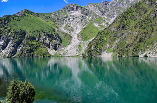

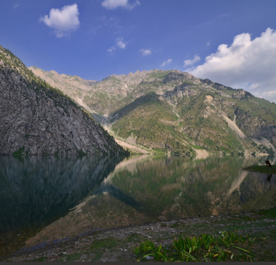


На пути к заповеднику Сары-Челек можно наблюдать множество живописнейших мест- одно из них озеро Кара-Камыш. Оно было образовано в результате крупного обвала, запрудившего реку Кара-Суу. Озеро получило название «Кара-Камыш» - «черный камыш», но нередко его называют Кара-Суу или Кара-Суу-Башикель в честь реки, образовавшей водоем. Длина озера Кара-Камыш составляет 1,5 км, а ширина 500 м.
Приозерная природа богата растительностью, здесь встречаются изумрудно-зеленые пихты Семенова и голубые тянь-шаньские ели. Горные степи покрыты зарослями шиповника, жимолости, боярышника и барбариса. Благодаря благодатным природным условиям на левом берегу реки Кара-Суу разрослись орехоплодовые леса. А на окрестных поселках производят уникальный по своим вкусовым и полезным свойствам горный мед.
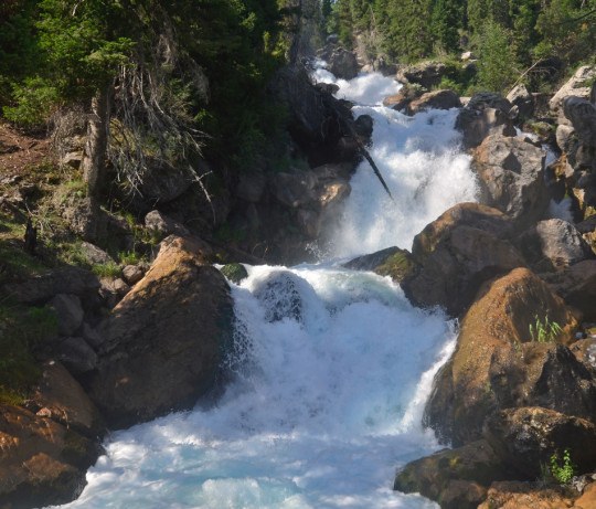
По дороге на озеро можно остановиться на водопаде Кара-Камыш. Огромные потоки воды, которые прорываются из озера в ущелье, а вокруг огромные вековые ели и пихты. Очень живописное место с отличной атмосферой.
On the way to the Sary-Chelek Nature Reserve, you can observe many picturesque places - one of them is Lake Kara-Kamysh.
It was formed as a result of a large landslide that dammed the Kara-Suu River. The lake was named "Kara-Kamysh" - "black reed", but it is often called Kara-Suu or Kara-Suu-Bashikel in honor of the river that formed the reservoir. Kara-Kamysh Lake is 1.5 km long and 500 m wide.
The lake-side nature is rich in vegetation, there are emerald-green Semenov firs and blue Tien Shan firs. The mountain steppes are covered with thickets of rosehip, honeysuckle, hawthorn and barberry. Due to the favorable natural conditions, nut-fruit forests have grown on the left bank of the Kara-Suu River. And in the surrounding villages, mountain honey is produced that is unique in its taste and beneficial properties.
On the way to the lake, you can stop at the Kara-Kamysh waterfall. Huge streams of water that break out of the lake into the gorge, and around there are huge century-old fir trees and fir trees. A very picturesque place with a great atmosphere.


Источник: https://t.me/+n72xRF1rSh81YmVi, /www.baibol.kg/ru/tourism-in-kyrgyzstan/attractions/lake-kara-kamysh, biaprom.ru/снг/kyrgyzstan/ozero-kara-kamysh/, //www.plantarium.ru/page/landscape/id/76590.html
#Kyrgyzstan#Kara-Kamysh#nature#nature aesthetic#landscape photography#mountains#trees and forest#lake#waterfall#blue sky#travel#wonderful#nature video#nature photography#Кыргызстан#Кара-Камыш#природа#Пейзаж#горы#лес#озеро#водопад#небо#туризм#видео природы#природнаякрасота
189 notes
·
View notes
Text
One of northwest tribes' longest-running battles. Saying this out loud is a big deal. The region has relied on irrigation and cheap clean electricity from the dams for generations.
The pictures in the article are nice, but they alone cannot tell the story of how they changed the river.
So here is one.

and here is another of the same location

The Columbia River is one of the largest in the United States. It is roughly comparable to the Danube in Europe. It cannot compare with the major rivers of Asia, Africa or South America, but it is still big.
It also drops quickly, and as it passes through the Cascade mountains it is forced through a fairly narrow gorge. Some of the effects of that can be seen in these pictures. The river is not at its largest here, but it is still not small. It was a violent and dangerous waterway. The Columbia River Gorge might be roughly comparable to the Iron Gates of the Danube.
The mouth of the river is still dangerous, even if it looks placid.
It is now a series of deep, fast-moving pools.
The dams allowed the region to enjoy cheap electricity and easy river commerce for generations, while once bountiful salmon became endangered.
1 note
·
View note
Text
Must Visit Places In Your Bangalore - Mysore - Ooty Tour

Ever dreamed of a vacation that has it all? Bustling city life, historical wonders, and breathtaking mountain escapes? Then pack your bags for South India! The Bangalore Mysore Ooty tour package covers the must-visit spots.
If you are in Bangalore, the exotic gardens and regal architecture are indeed a must-visit. Mysore offers majestic palaces and a rich history. Such is the beauty of Ooty that it is often addressed as the Queen of the Hill Stations. The serene landscape will surely be etched in your hearts forever. The beautiful city life of Bangalore, the serene atmosphere of Ooty, and the royalty at Mysore surely make up for the perfect South India tour.
Bangalore - The Garden City of South
Bangalore is much more than just corporate houses and big multinational companies. This city does have some beautiful spectacles that are a treat for the eyes.
Lalbagh Botanical Garden
The Lalbagh Botanical Garden is quite a well-known serene spot in Bangalore. The Lalbagh Garden witnesses the bloom of unique flowers every year that you might not find anywhere else. A unique thing about this place is the Glass House which resembles London's Crystal Palace and has an annual flower show. The peaceful lake is serene indeed!
Bangalore Palace
The next place that you need to visit when in Bangalore is none other than Bangalore Place. The palace looks like just a fairytale and it is modeled after England's Windsor Castle. The stunning architecture and old furniture are one of a kind. You will love the grandeur and its beauty.
ISKCON Temple, Bangalore
The ISKCON Temple in Bangalore is very well known. It has the largest complex when put in comparison with the other ISKCON temples in the world. The beautiful carvings and the peaceful ambiance will surely make you want to spend some time here.
Exotic Church Street
If you want to enjoy the city life of Bangalore and just unwind and relax, then Church Street is a must-visit. This place has got some of the best pubs and restaurants and you will find a host of culinary experiences here. Gorge onto some local dishes and satiate your taste buds.
Mysore: Royal Retreat and Cultural Delights
The next spot in this beautiful three-city tour package is the Palace City of Mysore. Some of the best places that you must visit when in Mysore are:
Mysore Palace
Start your tour of the beautiful Mysore city with none other than the royal Mysore Palace. Some of the unique features that make this palace unique are the detailed carvings, colorful glass ceilings, and mosaic floors. If you want to have an experience worth remembering then visit during the evenings. During this time, the palace decks up with a thousand lights.
Chamundi Hill
If you want the best view in Mysore, then you have to visit the Chamundi Hills. If you manage to drive to the top, you will witness the Chamundeshwari Temple as well. You can also stop at the Nandi Hill which is the longest statue in the world. Soak in the view of this place and feel liberated.
Brindavan Gardens
The Brindavan Gardens is a piece of heaven in Mysore. The garden overlooks the Krishnarajasagara Dam. Along with the serene views, you will also get to witness some exotic flower beds and fountains at the Brindavan Gardens. During the evenings there are special light and sound shows as well.
Ooty: The Queen of Hill Stations
And finally, this tour is not complete without the beautiful - Ooty. Some of the best places that you need to visit when in Ooty are listed here:
Ooty Lake
The Ooty Lake is one of the most beautiful places that you can come across in Ooty and the serenity and calmness will attract you to spend more time here. You can choose to rent a paddleboat or even a rowboat. The lake is surrounded by beautiful Eucalyptus trees all around.
Tea Museum and Factory
When in Ooty, you have to visit the famous team museum and factory. In this factory, you will be able to learn more about how tea is made. It is also possible that you try some tea variants and take some souvenirs back home.
Doddabetta Peak
If you are in Ooty, then it is a must to witness the enchanting Doddabetta Peak. This peak is the highest point of the Nilgiris and hence the view that you get is enchanting. If the weather is good, you can even go for an amazing drive. You will love every aspect of this Doddabetta peak and enjoy the surrounding view
Conclusion
Feeling inspired? Start planning your South Indian adventure today! Contact Swan Tours, one of the best tour operators in India. We offer a custom Bangalore Mysore Ooty tour package to meet your exact travel needs. Get in touch with us at Swan Tours today for the best packaged tour.
As one of the best tour operators in India, we help you plan a hassle-free tour. Contact us today and let us plan your next holiday.
0 notes
Text
Dear Xiao Zhan & Wang Yibo,
Hi. You don't know me because I am a slightly eccentric, white, retired lady with a spoiled Shih Tzu and dubious eyesight...but i digress.
As you two may recall, you both shot to fame in The Untamed (or CQL, as you probably know it better).
I watched your show in 2022, at which time I could not spell Beijing, let alone find it on a map.
Actually, it turns out - amusingly enough - i had the entire country of China in the wrong place in the map in my head (the same one where Reno NV is 5 miles from Las Vegas)!
I had China & Mongolia and Siberia/Russia completely flipped about. Who knew the Himalayas weren't near Shanghai! Not me!
Anyway,
Where was I? Oh, your live drama series. I'm a pushover for cute people in hanfu. And, see, I know translations are tricky to do well & can be awful (looking at you, Netflix).
So, i thought to myself, oh, it was somewhere in Episode 20 (around the time i wanted to punch Wei Ying in the face for being mean to Lan Zhan who had just spent 3 looooonng months in the wilderness with Jiang Cheng, aka "Grumpy Bro").
I thought: Self, if you could learn a bit of modern Chinese, you wouldn't be dependent on subtitles!
Yes! A brilliant idea!
And then i thought: Self, if you knew some Chinese history and some things about Chinese politics and culture, both ancient & modern, why if you did that, the drama (and Lan Zhan's speech patterns) would make more sense!
So, i hit the library. I googled. I watched history vids. I read articles.
And here we are, 2 years later, and I am still clueless why calling Lan Zhan "gege" (elder brother) is such a turn- on, but then, I don't get all the biting either. I just roll with it. Kind of like Wei Ying.
Fun fact: The Yangtze River is 6300 km long. It flows from a height of 5 km in the mountains all the way to Shanghai, where it dumps into the ocean in the same place it has for the last 11 million years. Except the Three Gorges Dam (built on ancient earthquake subsidence and fault lines) is stopping the silt from flowing into the area, so eventually poor Shanghai is going to sink beneath the rising tides of climate change. (Sure hope you guys don't own real estate there. Unless you want to swim in your livingroom).
Then there were oracle bones, the meaning of li, Confucious, chengyu, & the entire Han Dynasty, which gave me my favorite emperor, who is (given name) Liu Bang (劉邦). He was not a noble or even gentry. He schmoozed his way, more or less, into a job as a county deputy sheriff who was kind of lazy and drank a lot. A screw up (probably his) in a group prisoner transfer led to him becoming a war lord & then emperor of China. What's not to love!
So, thanks for it all, guys. I started out just wanting to fan girl you, and now I'm at least half-way into an associate degree in China, um, stuff. A bit eccentric of me, yes, but it keeps me off the streets and out of the pool halls, so i can't complain.
0 notes
Text
Flaming Gorge: The Ultimate Destination for Water Activities in Vernal
When it comes to exploring the great outdoors, few destinations can rival the breathtaking beauty and endless recreational opportunities offered by Flaming Gorge in Vernal, Utah. Nestled amidst the stunning landscapes of the Uinta Mountains and the Ashley National Forest, Flaming Gorge is a paradise for adventure seekers and nature lovers alike. With its pristine waters, rugged canyons, and abundant wildlife, it's no wonder that Flaming Gorge is hailed as one of the best spots for water activities in Vernal.
Things To Do in Flaming Gorge
Flaming Gorge is renowned for its expansive reservoir, which stretches across the border between Utah and Wyoming. The reservoir, formed by the impoundment of the Green River by the Flaming Gorge Dam, spans over 90 miles in length and boasts over 375 miles of shoreline. With its crystal-clear waters and stunning red sandstone cliffs rising dramatically from the shoreline, Flaming Gorge offers a picturesque backdrop for a wide range of water activities.
Thrilling Adventures
For adrenaline junkies and thrill-seekers, Flaming Gorge is the perfect playground. The reservoir's calm waters are ideal for boating, water skiing, and wakeboarding, while its numerous coves and inlets provide excellent opportunities for kayaking and paddleboarding. Anglers flock to Flaming Gorge in search of trophy-sized trout, including rainbow, brown, and lake trout, making it a premier destination for fishing enthusiasts. Additionally, the reservoir is a popular spot for scuba diving, offering divers the chance to explore underwater caves, rock formations, and submerged relics.
Spectacular Scenery
Beyond its recreational offerings, Flaming Gorge is celebrated for its stunning natural beauty. Visitors can embark on scenic boat tours or kayak excursions to marvel at the towering cliffs, lush forests, and hidden waterfalls that line the reservoir's shores. Hiking and biking trails wind their way through the surrounding wilderness, providing opportunities to encounter wildlife such as bighorn sheep, deer, and bald eagles. Sunset viewpoints offer panoramic vistas of the gorge bathed in golden light, making for unforgettable photo opportunities.
Family-Friendly Fun
Flaming Gorge caters to visitors of all ages, making it an ideal destination for families. The reservoir's calm, shallow waters are perfect for swimming and splashing, while designated swimming beaches provide safe and enjoyable experiences for children. Campgrounds and picnic areas dot the shoreline, offering opportunities for families to relax, barbecue, and roast marshmallows under the stars. Ranger-led programs and interpretive centers provide educational opportunities for youngsters to learn about the area's rich history, geology, and ecology.
Which Are The Best Affordable Hotels in Vernal?
Springhill Suites Vernal is one of the nice hotels near me, offering an inviting haven for bvgf travelers seeking affordability and adventure. Situated near Flaming Gorge, this hotel provides comfortable accommodations with modern amenities, ensuring a relaxing stay after thrilling outdoor escapades. Guests can start their day with a complimentary breakfast before embarking on adventures like rafting down the Green River or exploring the nearby Dinosaur National Monument. With its convenient location and budget-friendly rates, Springhill Suites Vernal is the perfect base camp for adventurers looking to immerse themselves in Vernal's natural wonders without compromising on comfort or cost.
When considering affordable hotels in Vernal with easy access to adventure, TownePlace Suites, Vernal stands out for its convenient amenities and proximity to outdoor attractions. Nestled amidst the rugged beauty of northeastern Utah, TownePlace Suites offers spacious suites, perfect for families or extended stays. Its strategic location places guests within reach of Flaming Gorge and its myriad of recreational activities, from hiking and fishing to boating and wildlife spotting. After a day of exploration, unwind in the hotel's outdoor pool or grill area, enhancing the adventure-filled experience without breaking the bank.
Planning Your Visit
If you're planning a trip to Flaming Gorge, there are several things to keep in mind. Be sure to check the weather forecast and water conditions before heading out, as conditions can change rapidly on the reservoir. Bring plenty of sunscreen, water, and snacks, as services may be limited in remote areas. And don't forget your camera – you'll want to capture every moment of your unforgettable Flaming Gorge adventure.
0 notes
Text
China Hydropower Market: Harnessing Nature's Power for Sustainable Growth
In the era of sustainability and renewable energy, the China Hydropower Market stands as a beacon of innovation and progress. With its vast network of rivers and mountains, China has capitalized on its natural resources to become a global leader in hydropower generation. This article navigates through the intricate details of the China Hydropower Market, shedding light on its significance, advancements, and future trajectory.
Understanding Hydropower
Hydropower, often termed as water power, refers to the generation of electricity by harnessing the energy of flowing or falling water. It is a renewable energy source that accounts for a significant portion of China's electricity production.
The Rise of China Hydropower
China's ambitious development plans have propelled the growth of its hydropower sector. As the world's most populous country, China faces immense energy demands, driving the need for sustainable and reliable power sources. Hydropower emerges as a key solution, offering clean energy while reducing dependence on fossil fuels.
Key Players in the Market
China's hydropower market is dominated by key players such as Three Gorges Corporation, China Yangtze Power, and China Three Gorges Renewables. These entities spearhead major hydropower projects, contributing significantly to the country's energy portfolio.
Infrastructure Development
The development of hydropower infrastructure in China is characterized by massive projects such as the Three Gorges Dam and the Baihetan Dam. These projects not only generate electricity but also provide flood control, navigation, and water supply benefits.
Sustainable Energy Source
Hydropower offers a sustainable alternative to traditional energy sources, helping mitigate greenhouse gas emissions and combat climate change. China's focus on renewable energy aligns with global efforts towards a greener future.
Overcoming Challenges
Despite its advantages, the China Hydropower Market faces challenges such as environmental concerns, resettlement issues, and geological risks. Addressing these challenges requires strategic planning and innovative solutions.
Technological Innovations
Advancements in hydropower technology, including pumped storage hydropower and run-of-the-river systems, enhance efficiency and reliability. China continues to invest in research and development to further improve the performance of hydropower facilities.
Future Outlook
The future of the China Hydropower Market looks promising, with ongoing investments in clean energy infrastructure and sustainable development initiatives. As China strives towards carbon neutrality, hydropower will play a pivotal role in shaping the country's energy landscape.
Buy Full Report for More Insights on the China Hydropower Market Forecast
Download A Free Report Sample
0 notes
Last Seen Blogs


kykac
Untitled

motherfuckinmox
a sick guy

nadjaofstatenisland
will you just spare us the middle-class morality

lamboutiquevn
lam boutique