#utility location
Explore tagged Tumblr posts
Visit Tumblr Blog
Explore Tumblr blogs with no restrictions, modern design and the best experience.
Last Seen Tumblr Blogs


Fun Fact
Tumblr has 411 employees.
Text
(also feel free in the tags to clarify Why you made the choice you made!! :0c)
#polls#tumblr polls#For me I think the top ones would be the House. The Money. or the Friend Group. But I ultimately might would go for the house#JUST becuase it would be my Dream House which means it would already meet mostly all of my specifications#and what I might be looking for. which would save a lot of time searching or customizing/rennovating.#Also because I could use that as a way to leave the US lol.. like .. if I get to choose my dream location.. couldnt I just choose some othe#country?? But I wonder how that works. Can you legally 100% have full ownership of a property in a country yet not be a citizen of that#country?? Would you show up and be like 'erm.. i own this house.. so i shall now live in it' and theyd be like 'uh no. you cant live here#despite owning the house. leave.' ??#So I think the initial process of 1. scraping together funds to actually MOVE myself and my most valuable belongings physically#TO another country. and 2. figuring out how to STAY in that country . might end up being difficult.. BUT. if I could just work that#part of things out then.. dream house?? security for once in my life?? stability?? :0#Though the $1mil is enticing it's also like.. I feel .. with the way housing prices are now... that's not much???#it's a lot I guess if you plan on like.. investing half the money and staying in an apartment for 5 years while you grow your wealth#or something. but if you're a 'I Need Stability NOW' ready to settle down person who would be most interested in owning a property rather#than nice clothes or a car or whatever other investments you could make then.. eh..?? It seems like unless you're okay with living in#a small town or kind of far away from the city - even some SMALL houses in majorly populated areas in the US will be like#$600.000 - $900.000 or something. like that would be MOST of my money. Which I know you could just pay partially and make#payments on it but idk.. in the option of just outright owning the house it seems like it'd end up being cheaper.#Plus I would want to own it fully asap because I'd be afraid of losing it somehow otherwise. like it being taken for medical bills or#something. which I thought was supposed to be - not IMPOSSIBLE - slightly more complicated legally if you actually have#paid off the house in full. I guess the issue then would be utilities and property tax and such. But I feel like thats overcome-able??#Like I could just stipulate that my Dream House has a little furnished addition or something and then find someone#with money and be like 'Look you can live in this extremely nice area with amazing ameneties and updated everything and ALL you have#to do is give me money to cover the utilities and property tax.'' or something like that. Like the little furnished addition is nicer#than the actual house. they have their own pool and spa and movie room or something and Ill also cook all their meals for them#or whatever (how luxurious it would be depeneds on how high the property tax actually is/how much I would need to entice them into#why it's a good deal for them to pay it for me lol). idk... something like that.. ANYWAY#I asked a few people I know though and one of them answered they'd rather have a romantic partner. the other one said they'd like#to be able to choose someone to die lol.. So I'm curious what people value the most
20K notes
·
View notes
Text
How Utility Locating Services Save Time and Money
Utility locating is a critical yet frequently overlooked process in construction and excavation. This process involves identifying and marking underground utilities such as water, gas, electric, and sewer lines.
Understanding the importance of utility locating services can significantly impact any project's efficiency, safety, and cost-effectiveness. Let's delve into how these services save both time and money, ensuring smoother project execution.
Prevention of Costly Damages
The primary way utility locating services save money is by preventing damage to existing underground utilities. Striking a single utility line can result in costly repairs, legal liabilities, and hefty fines from utility companies. For instance, hitting a gas line not only poses severe safety risks but can also lead to significant project delays and emergency repair costs. By accurately identifying and marking these lines before excavation begins, utility locating services help avoid such unforeseen expenses, keeping the project budget intact.
Reduction in Project Delays
Time is money in the construction industry. Unexpected encounters with underground utilities can halt progress, leading to significant project delays. These delays can be costly regarding extended labour and equipment rental costs and potential penalties for failing to meet project deadlines.
Utility locating services provide a clear roadmap of the subsurface infrastructure, enabling project managers to plan excavation activities more effectively. This foresight helps maintain project momentum, ensuring on-time completion and avoiding the financial burden of extended timelines.
Enhanced Safety Measures
Safety is paramount in construction and excavation projects. The presence of unknown utilities poses a severe risk to workers on site. Accidental utility strikes can lead to injuries or even fatalities, resulting in medical expenses, compensation claims, and increased insurance premiums. Utility locating services play a critical role in safeguarding worker safety by minimising the risk of accidents. This protects the workforce and saves money by reducing the likelihood of financial liabilities associated with workplace accidents.
Increased Efficiency and Resource Allocation
Knowing the exact location of underground utilities allows for more efficient planning and resource allocation. When the project team is aware of utility placements, they can strategise the most effective excavation routes, machinery placement, and workforce distribution. This optimised planning leads to more efficient use of resources, reducing wasteful expenditure on unnecessary labour or equipment usage. Consequently, utility locating services contribute to the project's overall efficiency, saving both time and resources.
Avoidance of Service Disruptions
Damaging utilities during excavation can lead to service disruptions, affecting not only the project at hand but also the surrounding community. The repercussions of such disruptions can extend far beyond the immediate repair costs, including potential compensation to affected parties and damage to the company's reputation. Utility locating services help maintain community relations and project goodwill by ensuring that essential services remain uninterrupted, thereby avoiding the indirect costs associated with service disruptions.
Conclusion
Utility locating services are an indispensable aspect of modern construction and excavation projects. Their role in preventing damage, reducing delays, enhancing safety, increasing efficiency, and avoiding service disruptions emphasises their importance in saving time and money.

As the construction industry continues to evolve, the reliance on these services will only grow, highlighting their value in ensuring the smooth and cost-effective execution of projects. For project managers and construction companies, investing in comprehensive utility locating services is a precautionary measure and a strategic decision that pays dividends in the long run.
0 notes
Text

Consider: character-exclusive trinkets.
#dandy's world#vee#vee version 1#vee dandys world#vee dw#dandys world vee#dw vee#glisten dandys world#glisten dw#dandys world glisten#dw glisten#glisten the mirror#so basically‚‚‚ vee gains the reflection ability but for machines and it works alongside camera hijack#glisten gets mic check but for toons and it works with reflection <3#and if you're curious about lore stuff for the trinkets. related to stuff i'm writing with a very dear friend of mine...#vee made the tracker as a gift for glisten after a. Particular Incident™ occurred#which eventually led to her learning the depths of his insecurities and issues. at least to *some* extent anyway#originally the tracker only tracked vee's location. just. so he could feel more comfortable.#know that he's never alone even if he can't actively sense anyone nearby with his abilities.#and so that if he ever needs vee for *anything* then he'll know exactly where to find her#but! it's got utility for vee in runs too! means she's always got someone to watch her back who can see when she's in danger and help out#but anyway. the fact that glisten could use the tracker to teleport longer distances was actually unexpected for vee!#and once she found that out she upgraded the tracker to show *all* the toons' locations#but only in runs and on the current floor because it relies on the machines to broadcast a signal. whereas vee can be tracked anywhere#the hand mirror was admittedly more of a 'hey it'd be cool to give vee a matching trinket. let my girl teleport to machines' thing gfhdhdf#but. while my friend and i haven't fully confirmed it? i've had thoughts of it being like. a 'thanks for putting up with me' gift#that glisten gave to vee sometime after the aforementioned Incident. because that mirror has Issues#and struggles to fathom that anyone would still want to be around him after learning that he's. broken. imperfect. even his best friend </3#the hand mirror has glisten's sweater skin's colour palette because i wanted to differentiate it from the vanity mirror#but also. it's silver. second place. it's enchanted with glisten's magic but it still doesn't measure up to the real deal (gold) <3
115 notes
·
View notes
Text


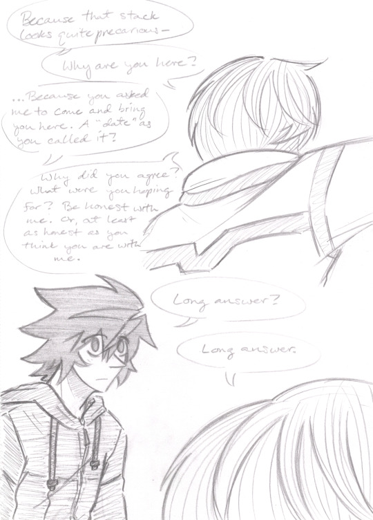

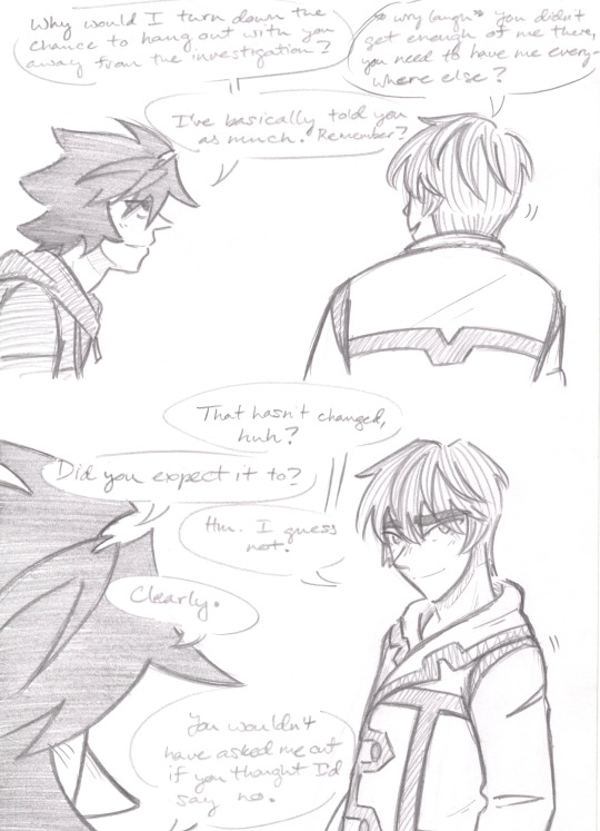
19 more images below the cut (WARNING: Some PG-13 saucy shenanigans ahead)
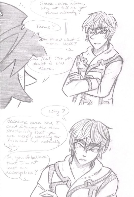

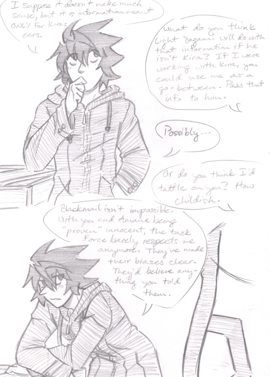

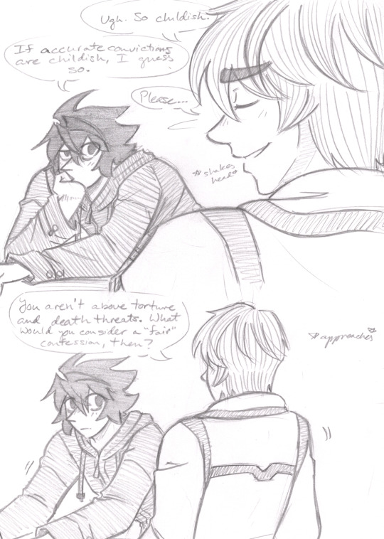

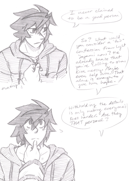

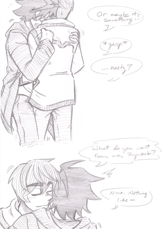
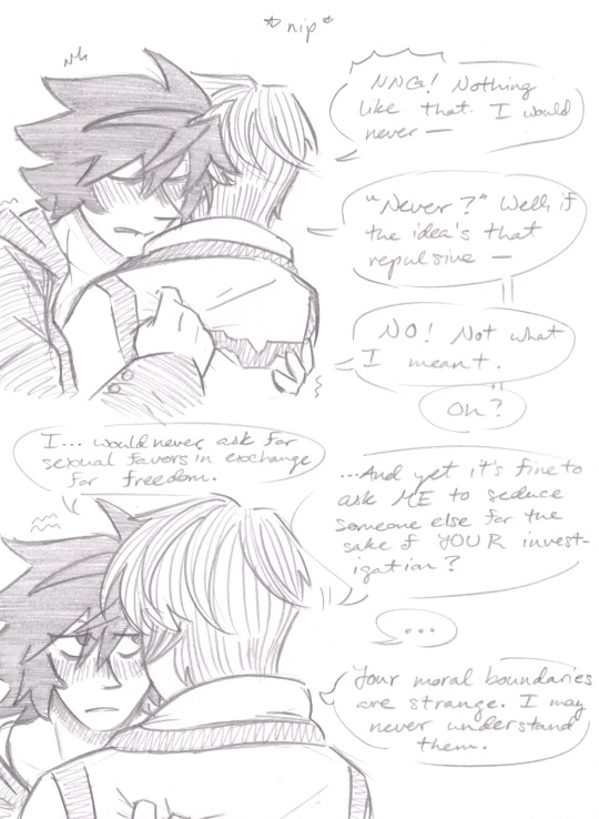

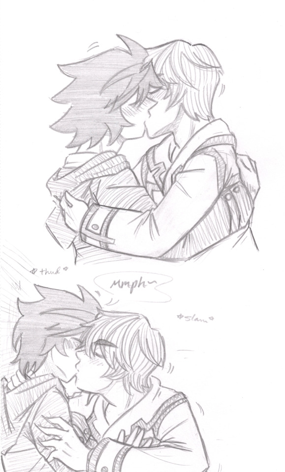
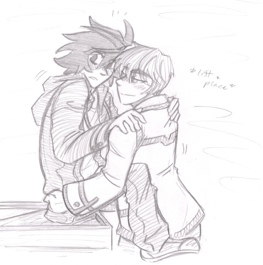
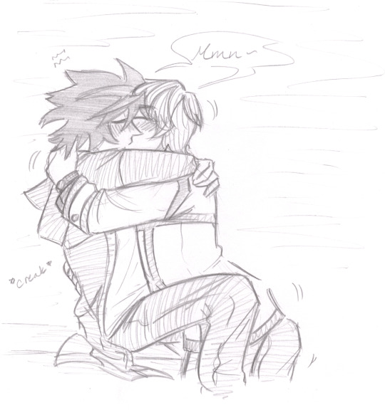

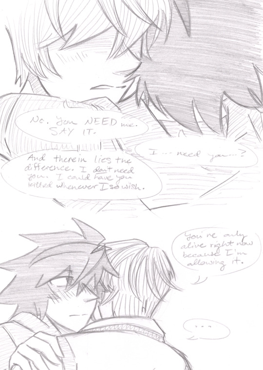

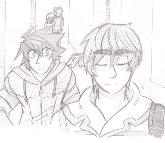
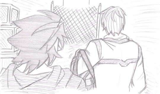
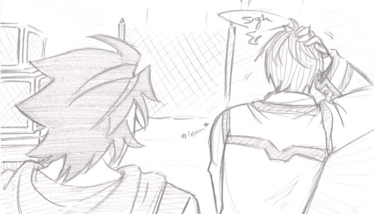
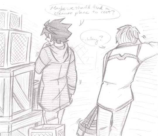
Part three of their date: an unconventional visit to a nearby alley so Light can clear his head and try to get to the point of the outing. The events lead him to becoming confident enough to move onto the next stage...
Next
Previous
First
Master List
Transcript
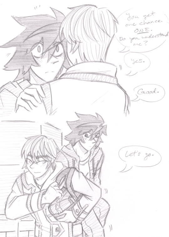
#drawn by me#my fancomic#The Chain#Death Note#lawlight#L#Light Yagami#saucy shenanigans#smooch#Light’s Kira is showing#those face-sucking images were very intimidating to do#but they were fun after I got over it lol~#I may share my other drafts of them making out and getting intimate that I did for this#it's pretty embarrassing XD#I gave up on the backgrounds. all that matters is that they're in an alley and there's a stack of boxes/wooden crates they utilize#happy early birthday L~#they are macking normally I suppose#but I just couldn't bring myself to write the sound effects. you all know what making out sounds like yes?#wanted to write “smooch smooch smooch” but it felt ridiculous and probably would've killed the mood lol#the kissing does actually serve a purpose. Hint: It's why Light feels better about going to the next location#maybe I’ll get the next installment out before the end of the year. 😑
299 notes
·
View notes
Text


The 2nd Mononoke movie trailer dropped and man he’s still so pretty to look at 🥰
#I got a lot and thoughts and feelings on the new trailer but ultimately I hope it’s just as good as the first movie#was expecting a new location and set of characters like how the show plays out but seems like that’s not the case here#we did get a lot of characters that weren’t utilized in the first movie tho and now I see they were being saved for the next one#aside from the story I know the animation will still be amazing I know it#and ofc can’t wait to see more kusuriuri he’s so fun to watch being animated and just so beautiful#he’s both my husband and wife with the way he is serving#sorry if these pics aren’t great btw I took them from my phone cause it’s late and I should be asleep#mononoke#kusuriuri
24 notes
·
View notes
Text
ori and the blind forest doesn't control v well for me. any deviation from perfectly left or right on the analog stick is interpreted as up or down instead which wrecks my movement in the precision platforming sections that are required to progress. my hands are cramped from trying.
#wish easy mode applied to the platforming too and not just the enemies#gameplay loop appears to be 1 go to area 2 get ability 3 you are literally not allowed to leave unless you can utilize this ability w the#proficiency of someone who's been playing platformers for years (or video games since they were young)#i kinda lowkey dissed arkham asylum by describing it as ''game journalist friendly'' but at least what i've played of that game didn't leav#me wondering if i'm supposed to have an ability from further up the skill tree by the third location in the game bc it's the only way i can#think to address the problem at hand#hollow knight wouldn't treat me this way (haven't played it) (only watched playthroughs) (wouldn't be able to beat path of pain)#in hollow knight your reward for getting a new ability is a bunch of goodies you can now access with the ability#in ori your reward is many deaths and increasing frustration until you can finally escape platforming hell#iggy plays#ori atbf
10 notes
·
View notes
Text
youtube
Yay!!!! my Circus Baby PMV is finally finished!!!
Here's a few choice screenshots:


#mvf art#video#pmv#fnaf#five nights at freddy's#five nights at freddy's sister location#fnaf sl#circus baby#fnaf circus baby#fnaf sl circus baby#elizabeth afton#purple guy#william afton#(but like just for a second sorry guys)#charolette emily#charlie emily#the puppet#the marionette#fnaf the puppet#fnaf the marionette#scrap baby#lefty#fnaf scrap baby#fnaf lefty#i'm back on my thoughts of 'i wish elizabeth and charlie had been friends :('#bc they're pretty interesting characters to get into!!!!!!!! but both not utilized very well!!!!!#also hehe now this is done i can get back to work on that mock anime opening......#Youtube
34 notes
·
View notes
Text
also if/when they remake sr1/sr2 i hope they make the train station an enterable building bc it’s genuinely one of the prettiest buildings in stilwater and i’d love to be able to go inside. plus it’d make for a convenient fast travel hub
#honestly i need to write a scene there somewhere at some point#it’s just a really gorgeous location. needs to be utilized#sr1 tag
4 notes
·
View notes
Text
random thought but Sonic's speed doesn't get utilized in storytelling as much as it should be ? why is it always "he's powerful/brave/special enough" and not "he's fast enough" ?
#i haven't got a clue on colours/archie/prime and maybe other sonic media but afaik none of these utilizes his speed either#idw almost did it with the metal virus but even that went nowhere as it was resolved by chaos emeralds & warp topaz#And it's?? not even as special as it shld seem ? no one cares anymore for how fast he is. which is ridiculous#when something surpasses the speed of the fastest thing alive you'd expect some sort of dread to befall the narrative but it never does#hmmmm#plz sonic has 3 locations he's here there & gone#this shld be important#☆ . ( ˢᵗᵘᵈʸ ) don't stop to look back again / don't fall .#EDIT im talking recent sonic media ofc. Shadow & Metal were great examples of when something actually keeps up with Sonic then#gets taken SERIOUSLY for it
4 notes
·
View notes
Text

Metro_Wireless_Node.jpg
#wikimedia commons#2000s#2009#Outdoor Wi-Fi antennas of access points#Municipal wireless networks#Dipole antennas#Mesh network#Utility poles in Minnesota#Files with coordinates missing SDC location of creation#CC-BY-SA-3.0#License migration redundant#GFDL#Self-published work#Taken with Polaroid i1035
2 notes
·
View notes
Text
as a fan of both fnaf and hhn, a fnaf house wouldn’t work as well as some of you think. universal only has the rights to the movie adaptation and i’d like you to think about how you’d adapt the movie JUST the movie into a house effectively. it can be done but it’d be (in my opinion) rather lame. there’s very limited locations and cast to include in the house, and also the costumes for the animatronics, if done well, would be really expensive. making multiple of the same characters wouldn’t be a worthwhile investment because they can’t be reused like michael myers masks can for example. there is a sequel coming out for the movie and it’s a MUCH better idea to wait for that to come out and do a house combining the installments of the movie franchise. we’ve gotten previews of the models for toy bonnie and chica so different characters are on the way. yes they are missing fnafs anniversary year, but if they do a fnaf house over and over every year for each new installment then the fnaf property at hhn will become what walking dead or stranger things has become at the event- repetitive and more like an interactive museum exhibit than an actual scare attraction.
#tldr BE PATIENT!!#also JUST MY OPINION!!!#when i talked about this with my friend i used killer klowns as an example due to the size of the costumes and location thing#but the costumes and props were turned from a prior scare zone and the killer klowns movie itself had enough stuff going on to add More#to the house#like the several animatronics and puppets utilized#and all the designs for the clowns are unique and different#unlike the consistency of the fnaf gang#which isn’t always a negative#but with the limited movements such a large costume would use and restraints of the setting and plot it would become really boring#to see them pop out constantly#halloween horror nights#hhn#fnaf#from the vault
5 notes
·
View notes
Text
How CAD Technology Transforms Accuracy and Efficiency in Land Surveying

Land surveying is a critical process in the fields of construction, engineering, and land development. It involves measuring and mapping the terrestrial or three-dimensional space to determine boundaries, land features, and property lines. Traditionally, land surveying relied heavily on manual techniques and rudimentary tools, leading to time-consuming and often error-prone results. However, with the advent of Computer-Aided Design (CAD) technology, the landscape of land surveying has transformed dramatically. CAD has brought about significant improvements in accuracy and efficiency, revolutionizing the industry. In this blog post, we will delve into the various ways CAD enhances land surveying and explore its benefits in detail.
The Role of CAD in Land Surveying
CAD, or Computer-Aided Design, is a technology used for creating, modifying, analyzing, and optimizing designs. In the context of land surveying, CAD software helps surveyors create detailed and precise maps and plans of land areas. The integration of CAD in land surveying involves the use of specialized software that allows surveyors to input data, process measurements, and generate accurate digital representations of physical spaces.
Enhanced Accuracy
One of the most significant advantages of CAD in land surveying is the enhanced accuracy it provides. Traditional surveying methods often involved manual calculations and hand-drawn maps, which were susceptible to human error. In contrast, CAD software offers tools that automate many of these processes, reducing the likelihood of mistakes. Here are some ways CAD improves accuracy:
1. Precision in Measurements: CAD software can handle and process complex mathematical calculations with precision. Surveyors can input raw data collected from the field directly into the software, which then accurately converts these measurements into detailed maps and models. This eliminates errors associated with manual data entry and calculation.
2. Detailed and Scalable Maps: CAD allows for the creation of highly detailed and scalable maps. Surveyors can zoom in and out without losing accuracy, enabling them to examine specific areas closely and ensure every detail is accounted for. This level of detail is crucial for identifying potential issues and making informed decisions.
3. Real-Time Data Processing: Modern CAD software can process data in real time, providing surveyors with immediate feedback. This capability allows for quick adjustments and corrections in the field, ensuring that the final survey is as accurate as possible.
4. Integration with GPS and GIS: CAD software often integrates seamlessly with Global Positioning System (GPS) and Geographic Information System (GIS) technology. This integration allows surveyors to import precise location data directly into their CAD models, further enhancing accuracy and providing a comprehensive view of the surveyed area.
Increased Efficiency
Efficiency is another key area where CAD excels in land surveying. The traditional surveying process was labor-intensive and time-consuming, often requiring surveyors to spend days or even weeks in the field. CAD technology streamlines many aspects of this process, leading to significant time savings and increased productivity. Here’s how CAD boosts efficiency in land surveying:
1. Automated Data Processing: CAD software can automate many of the repetitive and time-consuming tasks involved in land surveying. For example, it can automatically generate contour lines, calculate areas and volumes, and create cross-sections. This automation reduces the workload on surveyors and speeds up the overall process.
2. Simplified Data Management: Managing large amounts of data can be challenging, especially in large-scale land surveying projects. CAD software offers robust data management tools that allow surveyors to organize, store, and retrieve data easily. This simplifies the workflow and ensures that all information is readily accessible when needed.
3. Collaborative Capabilities: CAD software often includes collaborative features that enable multiple team members to work on the same project simultaneously. This collaborative approach enhances communication and coordination, leading to faster completion times and fewer misunderstandings.
4. Efficient Fieldwork: With CAD, surveyors can use mobile devices and specialized equipment to collect data in the field more efficiently. This data can be uploaded to the CAD software on the go, reducing the need for repeated site visits and minimizing downtime.
Visualization and Analysis
Visualization and analysis are critical components of land surveying, and CAD technology excels in these areas as well. The ability to create detailed visual representations of surveyed areas and perform in-depth analyses is invaluable for surveyors, engineers, and developers. Here are some ways CAD enhances visualization and analysis:
1. 3D Modeling: CAD software enables surveyors to create three-dimensional models of land areas. These 3D models provide a realistic representation of the terrain, allowing for better analysis and planning. Stakeholders can visualize the land’s topography, identify potential challenges, and make informed decisions based on accurate data.
2. Overlaying Data: CAD allows for the overlaying of different types of data on a single map. For example, surveyors can combine topographical data with utility lines, property boundaries, and environmental features. This comprehensive view helps in identifying potential conflicts and planning accordingly.
3. Simulation and Scenario Planning: CAD software can simulate various scenarios and predict their outcomes. For instance, surveyors can model the impact of construction on a particular area, assess potential drainage issues, or analyze the effects of environmental changes. This capability aids in proactive planning and risk management.
4. Detailed Reports and Documentation: CAD software can generate detailed reports and documentation based on the surveyed data. These reports can include measurements, calculations, maps, and 3D models, providing a comprehensive overview of the surveyed area. Such documentation is essential for legal, regulatory, and planning purposes.
Cost Savings
The improvements in accuracy, efficiency, and visualization brought about by CAD also translate into significant cost savings. By reducing errors and streamlining processes, CAD helps surveyors and their clients save money in various ways:
1. Reduced Rework: Accurate surveys mean fewer mistakes and less rework. Errors in traditional surveys often led to costly revisions and delays. CAD minimizes these errors, ensuring that the project stays on schedule and within budget.
2. Optimized Resource Allocation: Efficient data processing and management allow surveyors to optimize the use of resources, including time, labor, and equipment. This optimization leads to cost savings and better project management.
3. Minimized Site Visits: With the ability to process and analyze data remotely, CAD reduces the need for multiple site visits. This not only saves time but also reduces travel and labor costs.
4. Improved Decision-Making: Accurate and detailed surveys provide valuable insights that aid in decision-making. This leads to better project planning, fewer unforeseen issues, and more efficient use of resources, all of which contribute to cost savings.
Future Prospects of CAD in Land Surveying
As technology continues to advance, the role of CAD in land surveying is expected to grow even more significant. Emerging technologies such as Building Information Modeling (BIM), drones, and LiDAR (Light Detection and Ranging) are being integrated with CAD software, further enhancing its capabilities. Here are some future prospects for CAD in land surveying:
1. Integration with Drones: Drones equipped with high-resolution cameras and LiDAR sensors can capture detailed aerial imagery and topographical data. This data can be imported into CAD software for precise mapping and analysis. The use of drones reduces the time and effort required for fieldwork and provides access to hard-to-reach areas.
2. Building Information Modeling (BIM): BIM is a digital representation of the physical and functional characteristics of a building. Integrating BIM with CAD allows for a seamless transition from land surveying to construction planning and management. This integration improves collaboration between surveyors, architects, and engineers, leading to more efficient project execution.
3. Augmented Reality (AR) and Virtual Reality (VR): AR and VR technologies can enhance the visualization capabilities of CAD software. Surveyors and stakeholders can use AR and VR to explore 3D models in an immersive environment, gaining a better understanding of the terrain and potential challenges. This immersive experience aids in decision-making and improves communication.
4. Artificial Intelligence (AI) and Machine Learning: AI and machine learning algorithms can analyze large datasets quickly and accurately. When integrated with CAD, these technologies can automate complex analyses, identify patterns, and predict potential issues. This capability enhances the efficiency and accuracy of land surveying.
Conclusion
CAD has revolutionized the field of land surveying by improving accuracy, efficiency, and visualization capabilities. The precision and automation offered by CAD software reduce errors and streamline processes, leading to significant time and cost savings. As technology continues to evolve, the integration of CAD with emerging technologies such as drones, BIM, AR, VR, and AI will further enhance its capabilities, making land surveying even more efficient and accurate. For surveyors, engineers, and developers, embracing CAD technology is not just an option but a necessity for staying competitive and delivering high-quality results in today's fast-paced and demanding environment.
#Land Surveying#outsource cad drafting services#Surveying#Land Survey#Land Surveying Software#Land Survey Drafting Services#Land Survey CAD Drafting Services#Alta Survey#Subdivision Plats#Title Survey#Pipeline Surveys#Construction Survey#Site Planning Survey#Boundary and Location Survey#Topographic Survey#Residential Mortgage Survey#Tower Survey#Radius Map#Utility survey
2 notes
·
View notes
Text
Sorry I've learned that I'm the target audience of those excessive organizations tiktoks 😔
#maybe i do want extremely specific bins and locations for each and every one of my possessions and utilities#maybe so
3 notes
·
View notes
Text
Today's mood is going to be *rolls wheel* crying over the Devil of Caroc
#hablaty#admittedly i'm not really good at utilizing her but god does her writing fuck me up#i did her quest last night and just aaaa#her yelling ''I want a choice'' just aaaaaa#I'd say I want to give her a hug but her body has no nerves so she wouldn't even feel that :)#bc oh yeah she has no nervous system :) she only feels the pain of her soul being ripped from her body :) all the damn time :)#and then no matter how you handle her quest she'll die :)#and if you let harmke live her chest gets reforged into armor :) that you can buy :) and wear :) in the next game#obszidián wtf er*ic fe*nster*maker turn on your location I just wanna talk
9 notes
·
View notes
Note
Gimme Aruna's love language. You can't just say "And if you really want to make my day ask about Aruna" in the tags of your nov 18th post and leave me hanging.
i had to go digging for it but anon is referring to an old ask game post
that tag was more of a general anything-goes for aruna asks but rolling up sleeves alright let's tackle arguably one of the most difficult (delighted)
it's tricky because as a mobian, this guy is ~15+ years out of context, and 13 of those years were spent under circumstances that left him empty and just trying to survive (again, but worse). even in a kinder setting now with a new community and support system, he doesn't really act out of love so much as habitual responsibility.
he cares for the settlement he's taken up residence in and the people in it, and certainly some of that care is more personal on an individual level than others, but he doesn't view it as "love". he does those things because that's just what you're supposed to do? it's the same as how he'd act in his capacity as black doom way back when with his hive, just with slightly more emotional distance. a lot of what he does is ultimately still self-serving.
he helps build up this settlement and the people in it not because he wants to see it specifically succeed, or see them thrive, but because he lives there. but he's also not doing it just because he lives there and wants a safe place to live/for the people to feel compelled to treat him well. and while that's definitely how it started--he had to learn new etiquette rules and such to fit in and be more generally likeable enough for them to accept him--he still lacks a certain emotional investment in them.
like, yeah, it's love in the most basic sense, but it's hard to articulate why it's also not? they're his people now, in a sense, and he knows he belongs there, and recognizes when they show him love, but for his part he's just operating normally. he can't just be a freeloader or treat them like he's their leader instead. that's not how things work here. and besides, he'd go crazy without anything to do anyway. so like i said; most of what he does is still self-serving at its core. he just balances that and acts in such a way that it benefits more than just himself.
he lacks empathy and is selfish, but not in a way that damages others--and ensuring he keeps that balance is deliberate for the sake of staying in people's good graces. it is the literal definition of manipulative, but he's not doing it out of malice (anymore). he just wants to raise his chance of survival. he has nothing to live for but himself and the memory of his people.
in the present, if you shove all of that aside, and squint really hard past his barrier of invulnerability and neutrality, he shows it to specific individuals the most in what he lets them get away with. he hates being touched. is not very gentle or soft or kind in how he speaks. but he can be patient, and affords people close to him (especially children) some of his learned softness. he lets these chosen people hold his hand (even if he doesn't understand why) or hug him for their own sake (even if he's not particularly keen on the idea) or talks them down from anxiety or an upset (even if he is so, so bad at empathy and lacks the type of experiences that would help him navigate delicate situations).
back when he was still just regular black doom with a hive is different, though. i should preface this with the fact i write the black arms, especially in the context of aruna's hive, very differently from canon; they were all individuals with their own culture, and the hivemind was more of a shared telepathy ability rather than ant-like.
he was not overly-affectionate or outwardly sentimental, but he loved them all dearly in his own way, and it showed in subtleties. he was their leader, yes but they were everything to him. he would forego meals if it meant feeding a youngling instead. wore rings of the fallen and cycled them out with the most recently-lost to honor their memory. allowed younglings to get a bit clingy even though he hated being touched even back then. helped raise a lot of them, mourned the loss of the adults with the culture-appropriate equivalent of funeral, never forgot a single one of them, kept their stories alive until he no longer could.
all he has left are scraps and a monument the present-day settlement helped build. but he respects the settlement and acknowledges himself as one of theirs enough to integrate some of their funeral rites with his own due to being unable to put what remains of his kind to rest in the way he normally would.
#sea answers#aruna stuff#i can't believe i don't have a tag for this guy or his hive yet. one of these days i'll go back and fix that for older posts#he's kind of a wildcard in that he exists separately from the semi-modern or second chance worlds/timelines#seeing as the location he was in for about ten years meant he was severed from the normal flow of time. he's out of place in every sense#so he doesn't even really belong in the semi-modern au tag even though he's semi-modern's literal dad#he is truly the epitome of how a lot of my AUs utilize the multiverse
2 notes
·
View notes