#3dmap
Explore tagged Tumblr posts
Visit Tumblr Blog
Explore Tumblr blogs with no restrictions, modern design and the best experience.
Last Seen Tumblr Blogs


Fun Fact
Tumblr Inc. has $15.1M in annual revenue.
Text

For every Tarnished, a journey awaits! 🌍✨ Discover the Lands Between with this incredible 3D wooden map of Elden Ring, handcrafted with love for every adventurer. 🏔️🛡️
#EldenRing#LandsBetween#3DMap#HandcraftedArt#EpicFantasy#GamingCommunity#WallArt#GamerLife#FantasyWorld#DecorInspiration#eldenringmap
4 notes
·
View notes
Text

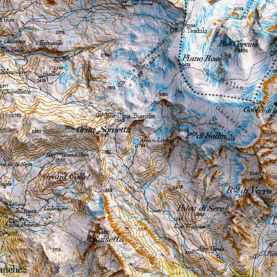
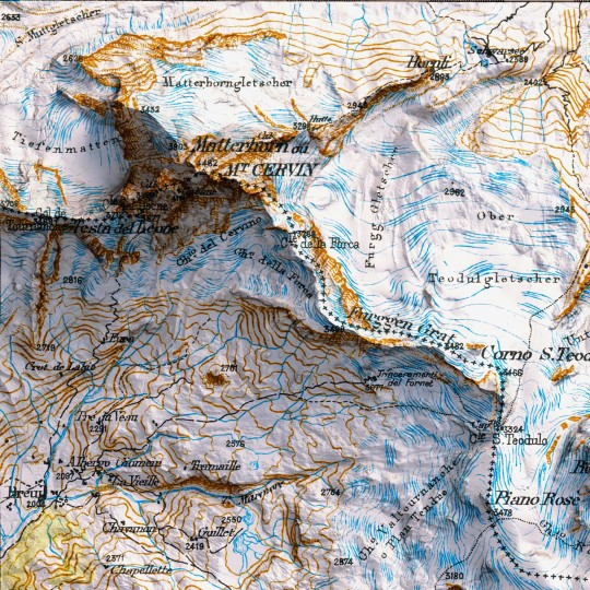
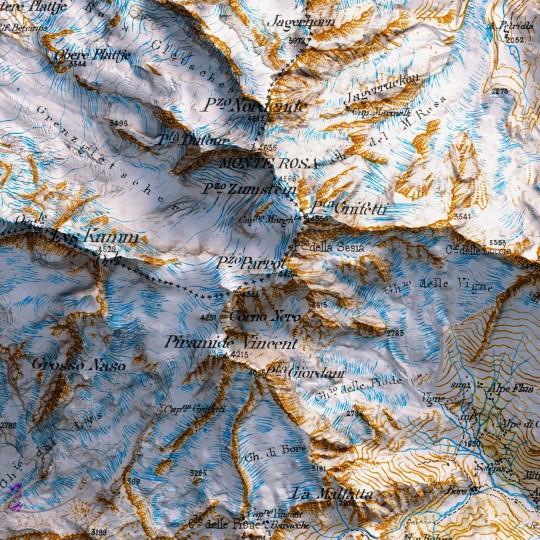
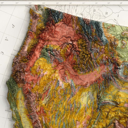
Time for a revamp!
An awesome 1898 map of the Mount Rosa from the collection "Carte du versant italien des Alpes 1899 - 1902".
If you like our work, want to see our daily updates (or want to say hello to our studio), consider to follow our Instagram or Twitter account. Otherwise if are interested in our prints or have a custom request check our shop.
#mattehornglacierparadise#mattehorn#cervinocinemountain#mtrosa#hickingadventures#topographicmap#3dart#3dmap#blender3d#geospatial#geospatialdata#datavizart#dataviz#datavizsociety#vintagemap#shadedrelief#alps#alpi#monterosa#mountain#valledaosta#piemonte#swissalps#italianmountains#vizart
0 notes
Video
youtube
luminbird @imapp 2024
Jury Award at iMapp Bucharest – Winners League 2024 – Legacy' 'Luminbird' 3D/ video: Ivó Kovács Music: József Iszlai Original 'Big-wing' motion courtesy of Derengo Animation, special thanks to La Luz. Organizers: Municipality of Bucharest, through CREART – Centre for Creation, Art, and Tradition of Bucharest iMapp Bucharest – Winners League partner: Parliament of Romania – Chamber of Deputies iMapp Bucharest – Winners League International partners: Chongqing Light Festival – CHINA, Video Mapping Festival Lille – FRANCE, Genius Loci Weimar Festival – GERMANY, 1minute Projection Mapping Competition – JAPAN, Zsolnay Light Festival – HUNGARY, ILO – International Light Festivals Organization
#3dmapping#imapp#imapp2024#imappbucharest#winner#bucharest#piataconstitutiei#jury's award#videomapping#videoart#bucuresti#projectionmapping#3d#ivo3d#3dvideomapping#projection-mapping#madewithnotch#parliament#luminbird#projection-art#newmedia#architectural-mapping#artists on tumblr
11 notes
·
View notes
Text
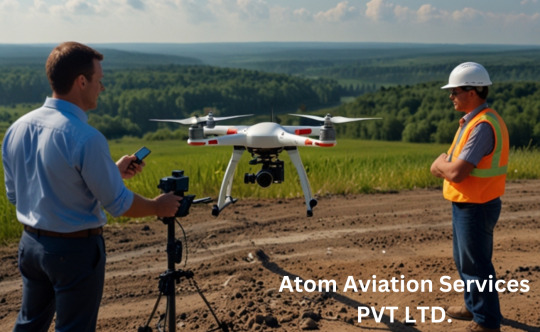
Drone Survey in the Real World: Revolutionizing Industries with Atom Aviation
In today’s rapidly advancing world, industries across the globe are turning to drone survey technology to revolutionize the way they collect data, perform inspections, and make critical decisions. Gone are the days of traditional surveying methods that are time-consuming, costly, and labor-intensive. Atom Aviation, a leading provider of drone surveying services, is at the forefront of this transformation, providing businesses with fast, accurate, and cost-effective solutions.

What is a Drone Survey?
A drone survey is an innovative approach that utilizes unmanned aerial vehicles (UAVs) to collect data from the air. Drones equipped with cameras, LIDAR (Light Detection and Ranging), and other sensors can capture high-resolution imagery, topographical data, and 3D models of vast areas in a fraction of the time compared to traditional ground-based methods.
This data is then processed into actionable insights for industries like construction, agriculture, real estate, and more, enhancing decision-making and project planning.
The Real-World Benefits of Drone Surveys
1. Speed and Efficiency One of the main advantages of using drones for surveying is the significant reduction in time. With traditional surveying, teams would have to manually visit every corner of a site, sometimes requiring several days or even weeks for large projects. In contrast, drones can complete the same tasks in hours, allowing businesses to access crucial data quickly and make decisions faster.
2. Cost-Effectiveness Drone surveying reduces the need for expensive equipment like helicopters or cranes used in traditional aerial surveys. Additionally, fewer personnel are required to operate the drones, further lowering costs. Atom Aviation ensures that businesses can enjoy these cost savings without compromising on the accuracy or quality of the data collected.
3. High-Resolution Data Drones are equipped with high-definition cameras and specialized sensors that capture data with exceptional precision. Whether it’s topographical mapping, volumetric analysis, or landscape modeling, drones provide a level of detail that is difficult to achieve with manual methods. This is especially crucial in industries like construction, where accurate measurements are essential for project success.
4. Access to Hard-to-Reach Areas In many industries, there are locations that are difficult to access using traditional surveying methods due to safety concerns or physical barriers. Drones can easily navigate hazardous environments, such as construction sites, power lines, or agricultural fields, ensuring that no area is left unexamined.
5. Minimal Disruption Unlike ground-based surveying, which may require disturbing the environment or disrupting normal business operations, drone surveys are non-invasive. They can operate without disturbing ongoing work, making them ideal for active construction sites or agricultural fields.
How Atom Aviation is Leading the Charge
Atom Aviation is a company that has harnessed the full potential of drone surveying to offer customized solutions for businesses across various sectors. With their fleet of state-of-the-art drones and highly skilled pilots, Atom Aviation ensures that every project, no matter how large or small, is completed with precision and efficiency.
Atom Aviation’s drone surveying services have been particularly valuable in the following industries:
Construction: From land surveys to site inspections, drones help construction companies keep projects on track and ensure compliance with building codes and regulations.
Agriculture: Drone surveys allow farmers to monitor crop health, assess soil conditions, and make data-driven decisions to maximize yield.
Real Estate: Property developers and real estate professionals use drone surveys to create accurate 3D models and aerial maps of properties, helping to market developments and make informed investment decisions.
Infrastructure: Drones enable inspectors to assess bridges, powerlines, and pipelines, identifying potential issues without the need for dangerous manual inspections.
Why Choose Drone Surveying with Atom Aviation?
Choosing the right provider for drone surveying is crucial to getting accurate, reliable results. Atom Aviation stands out for several reasons:
Advanced Drone Technology: Atom Aviation uses the latest drones equipped with cutting-edge cameras and sensors for precise data collection.
Expert Team: Their team consists of certified drone pilots and experienced surveyors, ensuring that all data is collected safely and accurately.
Tailored Solutions: Whether you need topographic surveys, volumetric analysis, or 3D mapping, Atom Aviation offers services customized to meet the unique needs of your project.
Timely Delivery: With a commitment to efficiency, Atom Aviation delivers survey data quickly, enabling businesses to make decisions without delays.
Conclusion
The application of drone surveys has brought about a significant change in how businesses approach data collection and site analysis. With companies like Atom Aviation leading the way, industries now have access to faster, more cost-effective, and highly accurate surveying methods that enhance productivity and decision-making. Whether you're in construction, agriculture, real estate, or infrastructure, Atom Aviation is the partner you need for cutting-edge drone surveying solutions.
For more information on how Atom Aviation can assist with your next drone survey, visit their website today and discover how they can take your business to new heights!
Keywords Used:
Drone survey
Atom Aviation
Drone surveying services
#drone#drone survey#drone surveying#dronetober#survey#mining#AerialSurveying#DroneData#ConstructionSurveying#TopographicMapping#AtomAviation#UAVSurvey#3DMapping#LandSurveying#RemoteSensing
2 notes
·
View notes
Text

Over 98% Of arrhythmias can be treated with EPS Study, RFA, and 3D Mapping This technology helps cardiologists view real-time 3D images for complex cases like Atrial Flutter and Left Bundle Area Pacing. For More Information:- Visit -: www.drnityanandtripathi.com Location -: https://maps.app.goo.gl/zsD6wToesAMTLM9HA Follow us on Facebook: https://www.facebook.com/nityanandtripathicardiology Instagram: https://www.instagram.com/drnityanandtripathi1/ Linkedin: https://www.linkedin.com/in/dr-nityanand-tripathi-228850333/
#ArrhythmiaTreatment#EPSStudy#RFA#3DMapping#CardiologyInnovation#AtrialFlutter#HeartHealth#Electrophysiology#LeftBundleAreaPacing#AdvancedCardiacCare
0 notes
Link
#3Dmapping#ADAS#advanceddrivingassistancesystem#EpicGames#Fortnite#Futurride#Hawaii#human-machineinterface#Maui#navigation#QualcommSnapdragoncockpit#QualcommSnapdragonRide#QualcommTechnologies#Rivian#RivianR1S#RivianR1T#RivianUI#Rivianuserexperience#Rivianuserinterface#SnapdragonSummit2024#sustainablemobility#UnrealEngine#UX
0 notes
Text

#LiDAR#AutonomousVehicles#3DMapping#SmartCities#SensorTechnology#Innovation#Geospatial#DroneTechnology#AutonomousDriving#SpatialData#automation#industrialautomation
0 notes
Link
#CardiacCatheterization#MinimallyInvasiveSurgery#HeartHealth#CardiovascularCare#TAVR#3DMapping#RoboticAssistedSurgery#HeartDisease#Angioplasty#InterventionalCardiology#Cardi...
0 notes
Text

Dive into the mind-blowing world record feat of 3D projection mapping! join us as we explore the technical mastery and artistic vision behind the largest projection ever.
#ortmoragency#deliveringdigitalhappiness#3dprojectionmapping#projectionmapping#videomapping#3dmapping#SpatialAugmentedReality#augmentedreality#immersiveexperience#digitalart#projectionart#lightmapping#visualeffects#interactiveprojection#ProjectionShow#mediafaçades#mappingart#virtualrealityexperience#VR#projectiondesign#ProjectionTechnology#3dvisualization#projectionmappingart#interactiveinstallation#projectiondisplay#immersiveart#digitalprojection#projectionmappingshow#3danimation#HOLOGRAPHICPROJECTION
0 notes
Text
📷🖥️ 𝗣𝗵𝗼𝘁𝗼𝗴𝗿𝗮𝗺𝗺𝗲𝘁𝗿𝘆 𝗦𝗼𝗳𝘁𝘄𝗮𝗿𝗲 𝗠𝗮𝗿𝗸𝗲𝘁: 𝗖𝗮𝗽𝘁𝘂𝗿𝗶𝗻𝗴 𝘁𝗵𝗲 𝗪𝗼𝗿𝗹𝗱 𝗶𝗻 𝟯𝗗 𝘄𝗶𝘁𝗵 𝗣𝗿𝗲𝗰𝗶𝘀𝗶𝗼𝗻! 🌍
Photogrammetry software market is rapidly expanding, driven by advancements in 3D imaging and mapping technologies. Photogrammetry software enables precise measurement and visualization by converting photographs into accurate 3D models and maps. This technology is increasingly utilized across various sectors including architecture, construction, archaeology, and gaming. Enhanced capabilities in drone technology and the growing demand for high-quality 3D content are key factors propelling market growth. As industries continue to embrace digital transformation, the photogrammetry software market is poised for significant innovation and expansion.
🔗 𝗔𝗰𝗰𝗲𝘀𝘀 𝘁𝗵𝗲 𝗥𝗲𝗽𝗼𝗿𝘁: https://bit.ly/3KcjKNj

#business#PhotogrammetrySoftware#3DMapping#3d mapping#geospatialtechnology#vr#ar#markettrends#innovations#technolgy#prophecymarketinsights
1 note
·
View note
Text
Understanding Topographical Surveys: A Guide by Dolphin Engineer
At Dolphin Engineer, we understand the importance of topographical surveys in infrastructure development. A topographical survey is an essential step in the planning and execution of any construction project. It provides a detailed and accurate representation of the natural and man-made features of the land, which is essential for designing and building safe and functional infrastructure. This also includes everything from hills and valleys to buildings and roads. A topographical survey also called a topo survey for short, uses fancy equipment to measure distances, angles, and elevations (heights) across the land.
What is a Topographic Survey?
Have you ever wondered how engineers and architects plan those amazing buildings and winding roads? A topographic survey which is also known as a contour survey or land survey shows the exact location of both human-made and natural features on a parcel of land. it focuses on both horizontal and vertical aspects, providing information about the property. The reason behind a topographic survey is to define changes in elevation on a parcel of land, which is essential for planning land use.
Why Do You Need a Topographic Survey?
When buying, developing, or evaluating land, a topographic survey is the first step. A topographic survey is important in many cases, as it helps identify potential issues with the land. By identifying issues early on, you can find simple solutions, such as relocating building locations, adding proper drainage, or levelling the ground.
The Importance and Process of Topographical Surveys
At Dolphon Engineer we are an expert team of engineers who use to plan and design buildings, roads, and other structures. Developers need accurate land details to plan new subdivisions or commercial properties. Environmental scientists rely on these surveys to understand the landscape, and they also help resolve property disputes and define land boundaries. To conduct a topographical survey, surveyors gather existing maps and records, visit the site with tools like GPS and drones, process the data with computer software, and produce a detailed map or report showing the land’s features.
How is a Topographical Survey Done?
At Dolphin Engineer, we follow a systematic process to ensure accurate and reliable results. First, we do an Initial consultation here we connect with you to understand your needs and the specifics of the projects. Our team visits the site to gather data using advanced tools like GPS, drones, and total stations. Then we process the collected data to create detailed maps and models. after analysing provide you with the reports and visualizations, with 2D maps and 3D models.
Conclusion
At Dolphin Engineer, we understand the importance of topographical surveys in infrastructure development. Our team of experienced surveyors and engineers use the latest technologies and methods to provide accurate and reliable topographical surveys. Whether you're planning a new construction project or need to update an existing infrastructure, our topographical survey services can help you achieve your goals.
#TopographicalSurvey#LandSurveying#InfrastructureDevelopment#ConstructionPlanning#Engineering#LandDevelopment#GPS#Drones#SurveyingTechnology#SitePlanning#EnvironmentalScience#PropertyBoundaries#TopoSurvey#CivilEngineering#AccurateData#ProjectPlanning#LandEvaluation#SurveyingExperts#DolphinEngineer#3DMapping#2DMapping
1 note
·
View note
Text

Transform your space with our 3D wooden map of Yellowstone National Park. Perfect for anyone who loves the great outdoors! 🌄🏕️ #Yellowstone #NationalParks #WoodenMap #HomeDecor #NatureLovers
0 notes
Text


Time for a revamp of a too saturated vintage map. We decided to improve the readibility of the map, so this is a new, balanced USA map of 1874.
🗺️ 𝗠𝗔𝗣 𝗜𝗡𝗙𝗢 Geological map of the United States compiled by C.H. Hitchcock and W.P. Blake from sources mentioned in the text. 1874. Lith. by J. Bien, N.Y. Source: David Rumsey Collection
If you like our work, want to see our daily updates (or want to say hello to our studio), consider to follow our Instagram or Twitter account. Otherwise if are interested in our prints or have a custom request check our shop.
#usa#statesofamerica#vintageusa#nevada#Wyoming#california#newyorkcity#maine#TimeTravelCartography#VintageMap#antiquecartography#historicalgeography#OldWorldCharm#CartographicTreasure#ShadedRelief#VintageUSA#MapEnthusiast#3dmap#vizart
0 notes
Video
youtube
Napa Light Festival High Resolution Events 2024
Step into the enchanting world of "A Journey Through Time" – a mesmerizing 3D mapping spectacle brought to life by High-Resolution Events at the 2024 Napa Lighted Art Festival. Nestled within the historic Napa County Superior Court, this groundbreaking display seamlessly blends technology and artistry to create an immersive experience like no other.
Join us on a visual journey that transcends the boundaries of time and space. Marvel at the intricate details, vibrant colors, and captivating narratives that unfold before your eyes. As you watch, you'll find yourself transported to different epochs, exploring the cyclical nature of human existence and the passage of time itself.
Experience the magic of "A Journey Through Time" – where innovation meets imagination, and every moment is a testament to the limitless possibilities of creative expression.
witness the power of art to inspire and transform. Subscribe now and discover the wonder of High-Resolution Events' groundbreaking 3D mapping show.
0 notes
Text
Drone Survey and Mapping: The Future of Precision and Efficiency
Introduction
In recent years, the use of drones has revolutionized various industries, from agriculture to construction, and one of the most impactful applications has been in the field of surveying and mapping. Drone survey and mapping have become essential tools for professionals who require accurate, high-resolution data in a fraction of the time it would take using traditional methods. In this blog, we’ll explore why drone survey and mapping are gaining popularity, how they work, and why they might be the perfect solution for your next project.
What is Drone Survey and Mapping?
Drone survey and mapping involve the use of unmanned aerial vehicles (UAVs) equipped with advanced cameras, sensors, and GPS technology to capture aerial data. This data is then processed using specialized software to create detailed maps, 3D models, and topographic surveys. Unlike traditional surveying methods, drones can cover large areas quickly, safely, and with incredible precision.
Why Choose Drone Survey and Mapping?
Speed and Efficiency Drones can survey vast areas in a matter of minutes or hours, compared to days or weeks with ground-based methods. This speed is particularly beneficial for time-sensitive projects like construction site monitoring or disaster assessment.
Cost-Effective By reducing the need for heavy equipment, manpower, and time, drone surveys significantly cut down on costs. They also minimize the risk of errors, which can be expensive to correct later.
High Accuracy Modern drones are equipped with advanced sensors like LiDAR and photogrammetry cameras, which capture data with centimeter-level accuracy. This makes them ideal for creating detailed topographic maps or 3D models.
Safety Drones can access hard-to-reach or hazardous areas, such as steep slopes, unstable terrain, or disaster zones, without putting human surveyors at risk.
Versatility From agriculture and mining to urban planning and environmental monitoring, drone surveys can be tailored to suit a wide range of industries and applications.
How Does Drone Survey and Mapping Work?
Planning the Flight Before launching a drone, surveyors plan the flight path using specialized software. This ensures complete coverage of the area and optimal data collection.
Data Collection The drone is equipped with cameras and sensors that capture high-resolution images, elevation data, and other relevant information as it flies over the area.
Data Processing The collected data is processed using photogrammetry or LiDAR software to create maps, 3D models, or contour lines. This step often involves stitching together hundreds or thousands of images to form a cohesive model.
Analysis and Reporting The final output is analyzed and presented in a format that meets the project’s requirements, whether it’s a topographic map, volumetric analysis, or a detailed 3D rendering.
Applications of Drone Survey and Mapping
Construction Drones are used to monitor construction progress, track stockpile volumes, and create as-built surveys.
Agriculture Farmers use drone surveys to assess crop health, plan irrigation systems, and optimize land use.
Mining Drones help in calculating stockpile volumes, monitoring mine sites, and ensuring compliance with safety regulations.
Environmental Monitoring Conservationists use drones to map forests, monitor wildlife, and assess the impact of natural disasters.
Urban Planning City planners rely on drone surveys to create detailed maps for infrastructure development and zoning.
Choosing the Right Drone for Survey and Mapping
When selecting a drone for surveying and mapping, consider the following factors:
Payload Capacity: Ensure the drone can carry the necessary cameras and sensors.
Flight Time: Longer flight times allow for larger areas to be covered in a single mission.
GPS Accuracy: High-precision GPS is essential for accurate data collection.
Software Compatibility: The drone should be compatible with industry-standard mapping software.
Popular drones for surveying include the DJI Phantom 4 RTK, senseFly eBee X, and WingtraOne.
The Future of Drone Survey and Mapping
As technology continues to advance, the capabilities of drone survey and mapping are only expected to grow. Innovations like AI-powered data analysis, real-time mapping, and improved battery life will make drones even more efficient and accessible. Additionally, the integration of drones with other technologies, such as augmented reality (AR) and the Internet of Things (IoT), will open up new possibilities for industries worldwide.
Conclusion
Drone survey and mapping have transformed the way we collect and analyze spatial data. With their unmatched speed, accuracy, and versatility, drones are becoming an indispensable tool for professionals across various fields. Whether you’re a land surveyor, a farmer, or a construction manager, incorporating drone technology into your workflow can save time, reduce costs, and improve the quality of your projects.
If you haven’t yet explored the potential of drone survey and mapping, now is the time to take flight. The sky’s the limit when it comes to what you can achieve with this cutting-edge technology!
Call to Action Ready to elevate your surveying and mapping projects? Contact us today to learn more about how drone technology can benefit your business. Let’s map the future together!
#DroneSurvey#AerialMapping#GIS#RemoteSensing#LidarTechnology#Geospatial#TopographicMapping#LandSurvey#UAVMapping#AerialSurvey#3DMapping#SurveyingSolutions#PrecisionMapping#DroneTechnology#MappingInnovation
1 note
·
View note
Text
0 notes