#projection-mapping
Explore tagged Tumblr posts
Visit Tumblr Blog
Explore Tumblr blogs with no restrictions, modern design and the best experience.
Last Seen Tumblr Blogs


Fun Fact
If you dial 1-866-584-6757, you can leave an audio post for your followers.
Video
youtube
luminbird @imapp 2024
Jury Award at iMapp Bucharest – Winners League 2024 – Legacy' 'Luminbird' 3D/ video: Ivó Kovács Music: József Iszlai Original 'Big-wing' motion courtesy of Derengo Animation, special thanks to La Luz. Organizers: Municipality of Bucharest, through CREART – Centre for Creation, Art, and Tradition of Bucharest iMapp Bucharest – Winners League partner: Parliament of Romania – Chamber of Deputies iMapp Bucharest – Winners League International partners: Chongqing Light Festival – CHINA, Video Mapping Festival Lille – FRANCE, Genius Loci Weimar Festival – GERMANY, 1minute Projection Mapping Competition – JAPAN, Zsolnay Light Festival – HUNGARY, ILO – International Light Festivals Organization
#3dmapping#imapp#imapp2024#imappbucharest#winner#bucharest#piataconstitutiei#jury's award#videomapping#videoart#bucuresti#projectionmapping#3d#ivo3d#3dvideomapping#projection-mapping#madewithnotch#parliament#luminbird#projection-art#newmedia#architectural-mapping#artists on tumblr
11 notes
·
View notes
Text
Watch on Youtube
Song- Dr. Sunshine is Dead by Will Wood
It is done!
Thank you all these wonderful people for being apart of this and working so hard on it!
Part 1: Me! Hello! Part 2: @kibbits Part 3: @piixelpaint Part 4: @nebuladreamz Part 5: @smoljeanius Part 6: @garbagechocolate Part 7: @garbagechocolate Part 8: @amberluvsbugs Part 9: @cookiiemancer Part 10: @cloudyvoid Part 11: @skizabaa Part 12: @circleheadd Part 13: @gopsnippers Part 14: @just-a-drawing-bean Part 15: @nosleepygayy Part 16: @soupdweller
Go send them some love if you love the MAP!
#dca animators project#fnaf daycare attendent#daycare attendant#sundrop#moondrop#fnaf sun#fnaf moon#fnaf eclipse#eclipse#five nights at freddy's#fnaf#dca map#daycare attendant map#mulitple animators project#daycare attendant multiple animators project#so many secrets to find#will wood
6K notes
·
View notes
Text
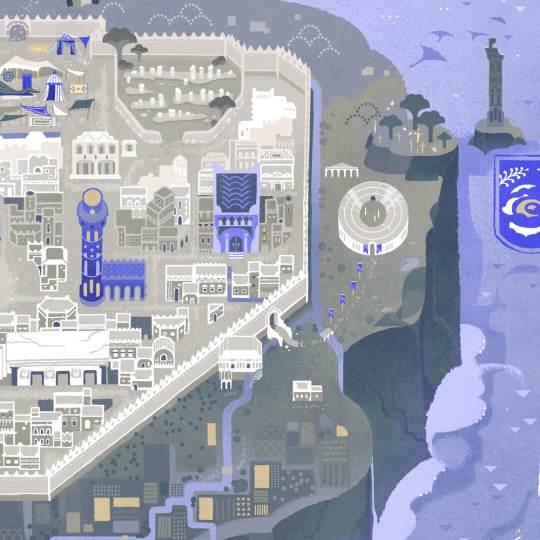
Here's what I've been up to lately! Three years after I created the original version, here's a revamp of the first planet I mapped out for @jayrockin's "Runaway to the Stars" project, the homeworld of their Centaur aliens. This post covers Phase One: Geology.


Firstly, the Equirectangular elevation maps with and without the color gradient layer, and tectonic plate map. This color gradient marks sea level, of course, and while there are inland areas that are *also* below that elevation, I have yet to determine which of those basins have lakes and seas therein, and how their shorelines compare; *that* will be seen once I figure out the climate : ) As for the Plate map, most of the smaller, oblong plates without any rift boundaries represent island chains or continent fragments that accreted onto larger landmasses; discretely marking those was helpful for placing and shaping the mountain ranges.


Next, the Poles-Centered Perspective maps, made possible with Photopea's Polar Coordinates tool. The planet's Southern hemisphere, centered on the south pole, is seen at left, and its Northern hemisphere is seen at right. Like the previous set of three, this set includes the color elevation map, greyscale elevation map, and solid color tectonic plates.


Last of all, the basis for the planet's current appearance: it's tectonic history! These gifs, in six frames, cover about 200 million years of continental drift, starting with the breakup of two Supercontinents, and was primarily achieved in Blender. This isn't my first time trying to reconstruct a tectonic history, but it *is* my first time doing so this quickly and efficiently, thanks to the process I developed here using this planet's continents as a test case.
There will be more phases in this project completed and shared in the coming months, thanks for checking out this one! Also, I've already shared these maps on Reddit, where you should be able to see them in even higher resolution. Photopea and Blender, 2025
#mapmaking#imaginary maps#photopea#blender#elevation maps#equirectangular projection#poles-centered perspective#rtts centaurs#fictional planets#runaway to the stars#worldbuilding#world map#imaginary plate tectonics#tectonic history sequence#physical geography#long term project#commissioned mapmaking#Christopher Maida Artwork
617 notes
·
View notes
Text
- DIE TOTENINSEL -
Usually I don't like posting my parts for animation projects on their own, but I think that with the audio changed this one stands pretty well on their own.
#Confession time: this was supposed to be fully animated#but I had a deadline and I ran out of time#i still think it looks pretty nice tho#Also when I mean “animation projects”#most of the time I'm talking about Multiple Animators Projects (MAP)#but I can't just say MAPs because sadly that acronyms also has terrible connotations out of the context the YT animation community uses it#oh well#signalis#signalis fanart#elster signalis#lstr#ariane yeong#my art#animation#(... mostly at least)
983 notes
·
View notes
Text

the narcissist fools himself
#IM GETTING A BAD GRADE IN POLYSHO WEEK WHICH IS NORMAL TO FEAR AND POSSIBLE TO ACHIEVE.#project sekai#pjsk#prsk#proseka#polysho#polysho week 2024#tsukasa tenma#emu otori#nene kusanagi#rui kamishiro#domt scroll dowm to when i pisted the sketch a year ago actually. should i delete that#Nah who give a fuck#They dont need to know that i drew this over a year ago and touched it up c all of my other drawings for this theme sre too ambitious#I cant draw a fucking merrygoround. Who am i kidding.#I posted this now so i can stop adding minute gradient maps to it for a 0.2 percent color difference. must sleep. farewell.#more polysho week to come. the day 5 prompt.. well. heh#also FUCK i want to do day 4 too bc i love the yokai theme but thats Today and i AAAAAHG ok stop itz GOONIGHT.#funny drawing for the guy that turned romeo and juliet into fortnite. stop crying and hop on duos
1K notes
·
View notes
Text
i dont usually post my map parts here but i spent like 4 months on this shit and im really proud of it lol
here's it on yt if you'd like
also PLEASE if youre interested in animating utmv PLEASE join the map we got a couple of parts still open and itll be really cool if it got finished
Map part for @thetroubledpencil
#i do not envy jakei at all this shit was obnoxious#surprisingly ink was the worst#hes too detailed lol#undertale#undertale au#inktale#errortale#ink sans#error sans#animation#map part#multi animator project#art#my art#battle animation#errorink#errink#errink qpr#sansshipping#mirrorshipping
545 notes
·
View notes
Text

Although Kansas is widely thought to contain the geographic center of the contiguous 48 states, topologists now believe that it's actually their outer edge.
Bad Map Projection Exterior Kansas [Explained]
Transcript
[A distorted map of the contiguous United States with the states labeled, where the Atlantic and Pacific coasts and the Canadian and Mexican borders are located closest to the center, with there being a gray void in the middle of the map, while the central U.S. states are distributed in the edges of the panel, with Kansas being in all of the four corners of the map.]
[Caption below the panel:] Bad Map Projection #45: Exterior Kansas
1K notes
·
View notes
Text
my part for the hayloft ii artificer map :]
#rain world#rain world downpour#rw artificer#fanart#my art#animation#multi-animator project#map part#the artificer#slugcat#five pebbles#iterator#2024#video#undescribed#road untraveled (oc)
1K notes
·
View notes
Text


watched my friend kass play pressure on stream today n doodled sebastian n then she colored him :) super nostalgic shit. add this one to my collection of butch women on t btw
#sebastian pressure#sebastian solace#pressure roblox#making his third hand a mantis shrimp claw cuz why not. curled up. love the voice acting in this game!!!!#also it all looks like masseffect1 why does it all look like that. the font. akira brain blast gif#i was such a huge scp nerd as a kid. the files make me giggle w the way theyre written. rly feels like a passion project#im so interested in the random map generation in this one i did not know the roblox engine was capable of that#if anyone knows how it works pls leave a reply!#curds
327 notes
·
View notes
Text

Planning a very big embroidery project. Please pray for me 🙏

At least my needle-minder is on theme!
#look I want a first age map to hang up in my house#and so I’m gonna make one#even if it kills me#which is probably will#but what else am I supposed to do?#small reasonable craft goals?#don’t make me laugh#beleriand embroidery project
198 notes
·
View notes
Text
Sneak-peak of a light art group exhibition at Fénydóm Budapest/ my cell/part - 'instinct - ancestor' (omnisphere 2017 animation variant/adapted to the given space) from 01.03.2024 - 17.03.2024, another projection-mapping installation.
#fenydom#fenydombudapest#biodom#allatkertbudapest#primordial#projection-mapping#video mapping#artists on tumblr#media artist#visual#ivo3d#budapest#new media#particles#light art
50 notes
·
View notes
Text
hey!! im did this!!!!!!!!!!!!! winter to spring MAP part on youtube :D process video
#digital art#illustration#art#dinosaur#dino art#dinosaur art#paleo art#raptor#animation#animatic#MAP project#multiple animated parts#utahraptor#deinonychus#dromaeosaur
151 notes
·
View notes
Text
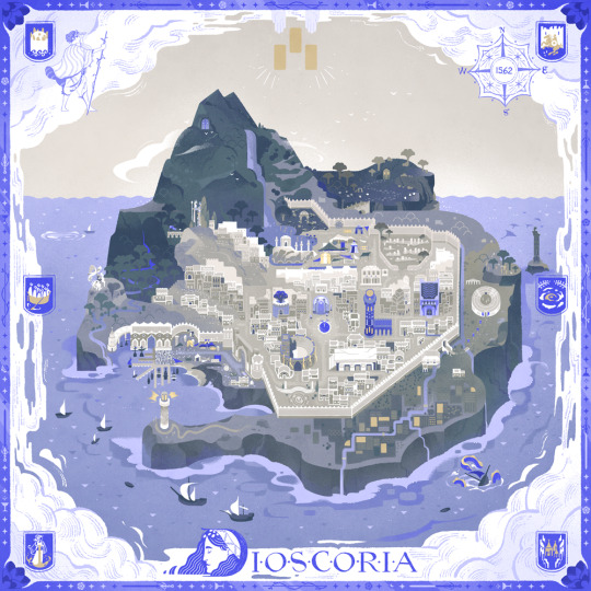
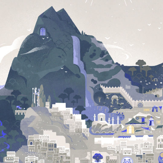
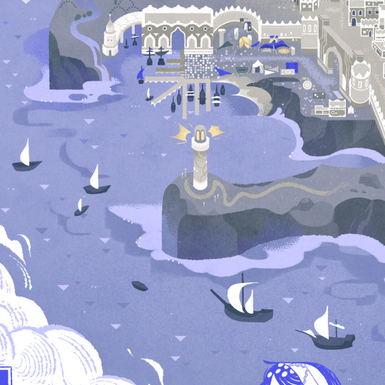
Discoria - The Hidden Isle 🌊
#illustrators on tumblr#artists on tumblr#illustration#ttrpg#the hidden isle#indie rpg#ttrpg community#island#map#nautical#maritime#seafaring#maps#sefirot tarot#Sefirot#had so much fun working on this map even though it took forever I'm so proud of it!#feel free to check out our newest Sefirot project
2K notes
·
View notes
Text
The Moon Doesn't Mind, Hollyleaf MAP - Part 10! 🌙
Here my part of this MAP! I love so much the designs, scripts and music of this MAP, this is hosted by Nymitri! She's doing an excellent job with her advice and feedback, go check out MAP Call and her art! I'm very grateful to participated in this MAP :'>
🌙 MAP CALL 🌙
youtube
🌙 My MAP part on YT (with the process!) 🌙
youtube
#art#my art stuff#artists on tumblr#digital art#warrior cats#animation#warrior cats animation#hollyleaf#hollyleaf warrior cats#hollyleaf wc#warrior cats map#map part#map project#Look at the designsss aaa#Youtube
716 notes
·
View notes
Text
Meteor Shower Craig x Tweek | COMPLETED MAP
A MAP (multi-animator project) dedicated to Craig x Tweek! This is a collaboration of 29 artist, please consider supporting those who are featured in the project. Thank you!
#map#multi animator project#tweek x craig#craig x tweek#south park#south park animation#animation#collaboration#animation collab#south park fanart#tweek tweak#craig tucker#sp craig#sp tweek
247 notes
·
View notes
Text
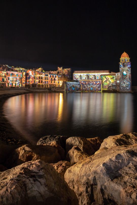
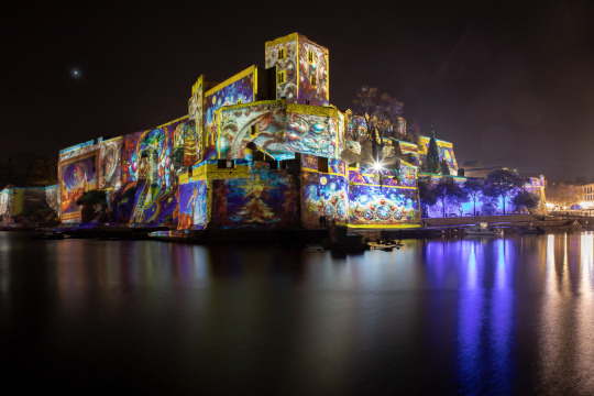
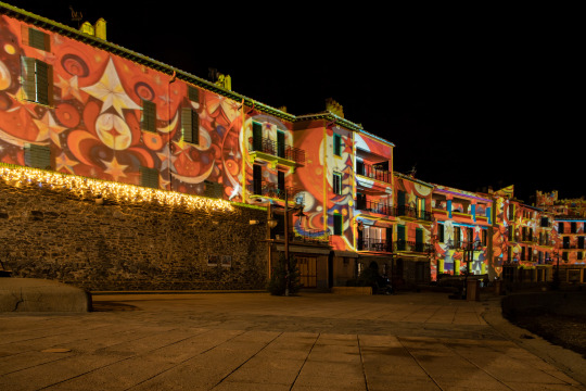
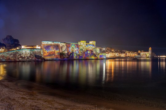
Building projection mapping in Collioure (2), by sir20
#original photographers#photographers on tumblr#photography#fine art photography#artists on tumblr#sir20#photographie#fotografía#fotografia#fotografie#original photography#creators on tumblr#collioure#occitanie#france#europe#mediterraneo#mediterranean#sea#seascape#night photography#night#projection mapping#projection art#long exposure#longexposure#urban landscape#cityscapes#cityscape#urban
185 notes
·
View notes