#GIS Data Conversion
Explore tagged Tumblr posts
Visit Tumblr Blog
Explore Tumblr blogs with no restrictions, modern design and the best experience.
Last Seen Tumblr Blogs


Fun Fact
Tumblr is used by 21% of adults online aged 18-29 years.
Text
0 notes
Text
0 notes
Note
please, can I request for angst no comfort (if you’re uncomfortable doing that it’s alright!) with Dan Heng? I think being on tumblr changed me? I crave so much angst now😞
or! If youre not in the mood, may I suggest fluff with Seth (ZZZ) or Heizou (GI) I BARELY see any Seth fics, only two on here, my bbg need more love than this! 🥺
thank you, I love your works!
-anon🧅
nightmares that bleed into reality

synopsis - his nightmares were frequent but now they seemed to hurt more than just him.
includes - dan heng
warnings - gn!reader, slight fluff, angst no comfort, arguments, wc - 575
a/n: as mentioned before, i wrote the seth one and posted it separately prior!!
it had been a more peaceful day on the express.
eventually, the tranquil day bled into the serenity of night that befell the train. everyone had resigned to their respective rooms which included you and dan heng. most days you would retire in your actual designated room, but occasionally you would join dan heng in his.
well, it was the data bank and so you only really started joining him when he fulfilled his promise of getting something a little more comfortable as a bed. you weren't asking much, just something more than pillows and blankets strewn across the hard floor, which was mainly solved by a roll mat or something similar.
simple conversations soon turned into hushed whispers as to avoid waking any other passengers - not that it was easy to. it wasn't too long until you both ended up lying side by side, legs entangled, and slowly drifting off into serene slumber. the express finally became cloaked in an entire veil of silence.
one that didn't last long. everyone was asleep. and yet, dan heng started tossing and turning. his mind was being tormented by violent visions. memories that didn't belong to him flashed through his mind, holding so much pain and suffering that it caused unease to settle in his mind.
you both knew it wasn't unusual for dan heng to have nightmares. they were the main reason that he didn't want to start sharing a room with you. dan heng feared that if he woke up, he'd wake you up and burden you with his problems - it was a common fact that dan heng didn't get much sleep because of them, he didn't want it rubbing off on you.
at first, it wasn't an issue. sure he did wake you up occasionally but it didn't take you long before you found says to help him calm down. dan heng actually found his nightmares more manageable with you around. whether that was because you helped him ground himself or simply because of your presence.
but tonight was worse.
he went through his usual tossing and turning before shooting up in a cold sweat. immediately you were woken up and it only took you a few seconds to realise he'd been shaken up by another nightmare.
you called out his name gently, sleep still heavily laced in your voice. unfortunately, dan heng was still caught up in what transpired in his nightmares. he couldn't recognise that you were beside him, that he was in the data bank. no. he thought he was in danger, and that you weren't who you were.
so he snapped. dan heng scrambled to push you away and pointed his spesr at you. you froze in pure terror.
it was only when his sleep muddled brain started clearing that he recognised you. the pure fear in your face that made his heart ache. dan heng was ashamed of himself. he shakily dropped his spesr and shakily moved away, what if he hurt you? what if he did something worse?
you couldn't even get a word out before he was asking, begging, you to leave.
taglist - @little-miss-chaoss, @frankiesteinn
#🧅anon↩#x reader#x gender neutral reader#honkai star rail x reader#hsr x reader#honkai star rail x gender neutral reader#honkai star rail x you#hsr x gender neutral reader#hsr x you#hsr dan heng#dan heng x reader
57 notes
·
View notes
Text
Episode 8 Queen of Tears BaekHong recap
Scene: Baek Hyun Woo’s universe has been Hong Hae In all along
The flashback to when Hyun Woo proposed to Hae In proves once again that Hyun Woo is a FOOL. That is his MBTI for sure. I’ll just combine this with episode 15 of this drama. At first I understand that it didn��t occur to him that it was all possible due to Hae In playing her chaebol card and renting all those places for them to date. But how is it possible that it never occurred to him after he knew that she is the heir to Queens Group? Making the connection is not that hard isn’t it? Anyhow… Hyun Woo really loves the universe in making decisions, doesn't he? He proposed to Hae In, believing that the universe is on their side and it is the sign for him to finally pop the question. He is such a simple and unassuming man. I’d just said it here, I really love this simple wedding band (yeah right, Bvlgari) from Hyun Woo instead of the other ring. I just loved it on her finger. Back to his universe, yeah, since Hae In was playing the universe all along, no wonder he never got the answer that he wanted for their divorce from the tiny leaves. No one is on his side in this world because his universe belongs to Hong Hae In entirely he will only realise it in episode 15.
I love the transition from their flashback to their current situation and again when Hae In remembered their memory from Germany and when she is back to reality once again. It was very beautifully crafted by the team. Back to the scene, Hyun Woo is hoping that this moment will last forever and Hae In will never remember their fight and his betrayal. But he would never allow that to happen no matter how bad the situation will turn out for him. He would rather face the consequences of his past self instead of being a more horrible human being to Hae In. He would rather she resented him instead of losing her to herself. Hae In finally able to remember the event in Germany and the harsh words that were uttered by Baek Hyun Woo and she was again traumatised by his words. She felt horrible that he’d seen her like this, in a situation where she is defeated by her illness and being cheated by herself and showing vulnerable emotion to Baek Hyun Woo, the man that despised her whom also the one made her life miserable. She finally makes up her mind…and they divorce.
Scene: In a day of Baek Hyun Woo
Hae In was reminiscing about the sunset they saw together when they were dating. We are already halfway through the series and all their dating flashbacks were heavy on Hae In being the only one exploring Hyun Woo’s life. She knows everything about Hyun Woo; his family, his hometown, his routine, his daily life but we never got anything about her while they were dating. It was obviously because he assumed that she was poor and even when she tried to explain it to him, he didn’t believe her. So, basically their relationship foundation prior to getting married was not strong. It was built based on assumption from Hyun Woo about Hae In, while she fully understands him and his lifestyle. So, their marriage is bound to find its own destruction anyway. Hyun Woo should’ve known and understood her family dynamic first before making the decision to marry her after she reveals that she is a chaebol. Instead, they got married right after because they were madly in love. While actually, he was at the beginning of knowing the “real” Hong Hae In. Hae In already has the data about him during their dating period but all the data about Hae In was new for him.
Hae In follows Hyun Woo’s steps because let’s be honest here… she fcking loves him and she misses her (ex) husband. She somehow started to really understand his life while they were married. She looked around and felt sad(?) that he was running alone while others were working out in pairs. When she overheard Hyun Woo and Yang Gi’s conversation, she felt guilty for being oblivious about Hyun Woo’s suffering throughout their marriage and somehow got her answer as to why he was always spending time alone. She also got to know that despite all that had happened, Hyun Woo still wanted to stay by her side.
I just love her dialogue to YES to put him at his place, to stop crossing the line, “I married (him) because I liked Baek Hyun Woo that said he’d be by my side, and I divorced him because I’m sorry for what he had to go through to be by my side.” The point is that she won’t just marry anyone because she needs to do it, she married Baek Hyun Woo because she liked him. Her husband will always be Baek Hyun Woo and no one else. She had never needed a man that can bring her more wealth because she is capable of doing it independently. She chose Hyun Woo because of his promise and above all because she loved him and still is. Despite Hyun Woo’s betrayal, it doesn’t change the fact that he is a good man which is something that YES can ever be.
Scene: Hae In to the rescue
Due to YES manipulation and Queens Family stupidity, Hyun Woo was being suspected as the whistle-blower and was denied access to the Queens Group intranet and building. My, my, my… there she is, his (ex) wife comes to his rescue. Who would believe that a divorced couple would protect each other like them? Who in their right mind would do that? Only them, Baek Hong couple supremacy! Anyway, it just occurred to me that this is actually the first time they talk to each other after the divorce. They seemed much more at ease after the divorce and silently doing their best to protect each other (fools!! Fools in love!) But, Hae In is angry and frustrated at Hyun Woo who was humiliated while he just silently enduring it. She was then perplexed by his response, “I’m doing this because I want to do it and still stay here where I wanted to”. Even in the middle of this, he still worried for her health. He will be ok as long as her condition is fine. See, this is why Hyun Woo is a good man. We knew it and even Hae In knew that he wanted to be by her side, but he never does anything to persuade her to accept him again. He is just there, waiting patiently and understanding her. A gentleman that respects her decision and silently protecting her.
Summary:
Like what he promised her in Germany, he will follow whatever decision she makes for their marriage and so far he is keeping it, much to our frustration of course. He accepted her decision to divorce, following her direction regarding the divorce settlement and respecting her space while still protecting her. He never made any effort to defend himself or make excuses to her, for he truly felt remorseful for his action. He only hopes for Hae In to continue her treatment and regain her health. His love for her is selfless. In the meantime,
Hae In wanted to live…
She also wanted to stay by his side… they wanted the same thing but what is stopping them? We knew that Hyun Woo is not gonna make a move until he knows that Hae In has really given him the forgiveness. The key is on Hae In but she knows her condition is not improving currently. Being together will only make them suffer and she doesn’t want that, especially for Hyun Woo I think. They just need some time to think and realise that they actually don’t have much time together to be wasting it by not being together.
#queen of tears#baekhong#rewatching#is this divorce couple#gentleman hyun woo#hae in protects hyun woo#hyun woo universe is hae in#lady boss hong hae in
11 notes
·
View notes
Note
Hello my love!! If you’re not doing ships anymore feel totally free to ignore this!!
I’m 5’7” and I have ginger/brown curly hair!! I’m a history student looking at specialising in cultural history at postgrad, particularly looking at music as a primary source. One day I hope to be a lecturer, but the academic job market in the UK is mega yikes at the moment lol! I also volunteer at my uni’s radio station which is so much fun!! This year I presented a show called Time Machine Tunes which looked at annual chart data from 1972-1994 and basically recreated highlights from the end of year chart shows of each year! Outside of uni stuff, I really love cooking, baking, and reading. I also like going to concerts and theatre shows (saw Hozier last night and I’ve still not recovered lol)!! I’m a mega hopeless romantic, and I grew up on books like Little Women and Emma, so whilst unfortunately I’m entirely inexperienced with the whole relationship thing I’m still very much holding out hope for my Mr Knightley/Laurie/insert romance novel character here!
Anyways if you get around to shipping me that would be lovely but no worries at all if not!! I hope you’re having a great day!! <3
- Gi :)
Hi there!!! Thank you, I hope you're having a great day too 🥰💗
🚢 below!
I love that you're into history and the Time Machine Tunes show sounds SO COOL!! 1972-1994 was an incredible time for music! (I'm also a hopeless romantic and I have no doubt you'll find your perfect person 🥰)
I love the idea of you and Steve going to the same university and one day he tunes into your radio station and hears you presenting! He never cared about history in school, but your thoughtful takes and the excitement you bring to the subject has him totally hooked.
After a few days, he's still thinking about your presentation!! He's even slipping chart data for music into his every day conversations and that's when Robin realizes, he's a goner. Maybe she calls the station to find out more about you for Steve 🥺 (without his knowledge of course) she just wants to see her bestie happy!! You and Robin become friends and after a while, she invites you to a concert and says "oh, by the way, my best friend Steve will be there" the sneaky little minx 😏
When you meet Steve and he recognizes your voice, he curses Robin for meddling in his love life. That is, until he feels his heart race when you smile at him, and he gets goosebumps when your arm brushes against his 🥺 then the two of you get to have your own life story 🥰
💗💗💗
3 notes
·
View notes
Text


sorry im making ya'll look at my niche GIS OCs-- picrew used is by hunbloom!
first is SHAPEFILE, or FILE for short. they were made in a lab (or so they say) to sell their soul to Esri and shill proprietary mapping software at every opportunity he gets. ridiculously charismatic and well-liked professionally, but thats because hes an annoying tech bro in conversation. data scientist in the streets, floating point variable in the sheets. resume says Geoff Shapiro, but good luck finding a birth certificate.
Quin Gizzard on the other hand would rather die than sacrifice her values as an open source evangelist, even if it means being the brokest dyke in town. programs plugins for QGIS for absolutely zero money but she pays her dates back for dinner in head. iNaturalist girlie with a focus on amphibians, plants, and fungus. weed dealer for the entire sapphic STEM network
both university grad students in geographic information systems. yes they hate each other. yes they have sex about it
oh and i color picked fucking pride flags from logos because im normal. FILE is dEsriboy and quins is GISbian
3 notes
·
View notes
Text
Benefits of Using Forward Geocoding
Forward geocoding is a foundational technology in modern geographic information systems (GIS), logistics, e-commerce, and digital mapping. By converting street addresses into latitude and longitude coordinates, forward geocoding unlocks powerful capabilities for businesses and developers alike.

1. Improved Delivery Accuracy With precise geolocation, businesses can ensure that deliveries are routed to the correct location, minimizing failed deliveries due to vague or incorrectly entered addresses.
2. Enhanced Mapping and Visualization Plotting addresses on maps helps businesses visualize customer distribution, identify high-demand areas, and make data-driven decisions for expansion or marketing.
3. Route Optimization Forward geocoding facilitates optimized routing for logistics companies. By mapping delivery addresses to coordinates, systems can compute the most efficient delivery paths.
4. Better User Experience in Applications Apps that allow users to enter addresses—like ride-sharing, delivery services, or travel apps—benefit from forward geocoding to match text entries with real-world coordinates quickly.
5. Location-Based Marketing Marketers can use geocoded data to launch hyperlocal campaigns based on users’ geographic location. This leads to higher conversion rates and better ROI.
6. Geofencing Capabilities With accurate coordinates from forward geocoding, businesses can set up virtual geographic boundaries to trigger alerts or marketing messages when users enter specific areas.
7. Integration with Spatial Data Analytics Combining geocoded addresses with demographic, traffic, or climate data enables richer analysis and insights. For example, retail chains can analyze which locations perform better based on neighborhood characteristics.
8. Scalability and Automation Modern APIs enable bulk geocoding, which allows companies to process thousands of addresses in minutes, boosting efficiency across CRM, logistics, and analytics platforms.
9. Better Customer Insights Understanding where your customers are helps with segmentation, demand forecasting, and personalized service delivery.
10. Regulatory Compliance and Taxation In e-commerce and finance, accurate geocoding ensures tax rates are applied correctly based on location, which is important for compliance and reporting.
Best Practices for Using Forward Geocoding
Clean Input Data: Ensure addresses are standardized before sending them to a geocoding API.
Use Reliable APIs: Platforms like Google Maps, HERE, and Mapbox offer high-quality results.
Handle Ambiguity Gracefully: Provide suggestions when addresses are incomplete.
Monitor API Usage: Track usage to stay within rate limits and manage costs.
Conclusion Forward geocoding offers immense benefits in terms of delivery accuracy, data visualization, marketing effectiveness, and operational efficiency. By turning textual addresses into precise geolocations, it empowers businesses to operate smarter, faster, and more accurately.
Whether you are building an app, launching a marketing campaign, or managing logistics, integrating forward geocoding into your systems gives you a competitive edge in today’s data-driven world.
youtube
SITES WE SUPPORT
Forward AusPost With Address – Wix
0 notes
Text
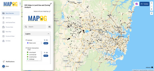
How GIS Helps in Land Use and Zoning Analysis for Better City Planning
Urban growth is accelerating, but planning for it often lags behind. One of the most common challenges faced by urban planners today is the lack of clarity on how land is being used—and misused—across city zones. Misaligned zoning laws, unchecked development, and overlapping land allocations can lead to traffic congestion, resource waste, and environmental degradation. So, how do cities solve this? This is where Geographic Information Systems step in, offering a smarter, data-driven approach to land use and zoning analysis.

Why GIS is at the Heart of Smart Zoning
GIS acts like a visual brain behind city planning. It helps planners map, layer, and analyze different types of land use—residential, commercial, agricultural, industrial—and determine how they interact. With GIS, zoning isn’t just a regulatory function; it becomes a living, evolving model that responds to physical changes.
One powerful way GIS supports this is through border intersection analysis. Imagine overlapping a city’s zoning map with its current land use dataset. You’ll instantly see where mismatches occur—for example, where industrial zones are creeping into residential neighborhoods, or where green spaces are disappearing due to unauthorized development. This makes it easier for planners to adjust policies, prioritize inspections, or even redesign city layouts more sustainably.
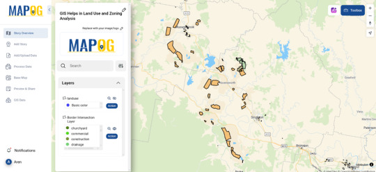
Who’s Using GIS for Land Analysis?
GIS isn’t limited to city governments. Industries like real estate, environmental consultancies, logistics, and even public health are tapping into spatial analysis to inform better decisions. A logistics company might use GIS to ensure their warehouse is placed within an industrial zone near main roads. Meanwhile, real estate developers check zoning layers before making large investments to avoid compliance issues down the line.
The Role of Platforms in Action
Platforms that support GIS storytelling and visual analysis—like MAPOG—offer an intuitive way to interact with spatial data. These tools allow users to upload zoning and land use files, perform border overlap analysis, and share the outcomes with decision-makers in a visual format. You don’t need to be a tech wizard to use them—just a few clicks, and the patterns reveal themselves.
If you’re exploring spatial zoning analysis for your city, community, or business, it’s worth trying out such platforms. They make the process more collaborative and less abstract—no more staring at spreadsheets when you can work with interactive maps instead.
Final Thoughts
Land use and zoning analysis isn’t just about keeping order—it’s about building better cities for people, for nature, and for the future. GIS enables urban planning to be grounded in facts, not just assumptions. And with access to visual mapping platforms, anyone—from planners to citizens—can become part of the city-building conversation.
#mapog#urban planning#GIS analysis#spatial analysis#LandUsePlanning#ZoningSolutions#data visualization#gis#mapping#smartcities#mapping tools
0 notes
Text
Sustainable Cities: Innovation in Urban Planning
As urban populations soar and environmental concerns intensify, the conversation around city development is rapidly evolving. Gone are the days when concrete jungles were seen as the pinnacle of progress. Today, the future belongs to sustainable cities—urban spaces that are thoughtfully designed to balance growth, environmental responsibility, and human well-being. In this blog, we explore how innovation in urban planning, green building, and waste management is reshaping the blueprint of modern cities.
The Role of Urban Planning in Sustainable Cities
At the heart of sustainable city development lies urban planning. This isn’t just about zoning or infrastructure—it's about creating inclusive, livable environments that prioritize accessibility, efficiency, and environmental stewardship. Innovative urban planning considers how people live, work, commute, and interact with the urban ecosystem.
Cities like Copenhagen, Singapore, and Curitiba are global leaders in sustainable urban planning. By integrating green spaces, promoting public transit, and minimizing sprawl, these cities reduce carbon emissions while improving quality of life. Mixed-use developments, pedestrian-friendly streets, and strategic transit hubs all contribute to a more cohesive and sustainable urban experience.
Innovative urban planning also means embracing data-driven decisions. Planners now use geographic information systems (GIS), sensors, and AI to analyze traffic, air quality, energy consumption, and more—helping cities respond dynamically to emerging needs and environmental pressures.
Green Building: Rethinking Urban Architecture
Urban structures consume enormous amounts of energy and resources. That's why green building is a cornerstone of sustainable cities. It refers to the design, construction, and operation of buildings in ways that reduce negative environmental impacts and promote health and well-being.
Green buildings utilize energy-efficient technologies, renewable materials, and systems that reduce water and power consumption. Features like solar panels, natural ventilation, rainwater harvesting, and high-performance insulation are common in eco-friendly designs.
Beyond individual structures, green building standards—such as LEED (Leadership in Energy and Environmental Design) or BREEAM (Building Research Establishment Environmental Assessment Method)—guide developers and city planners toward more sustainable construction practices. These certifications ensure that new developments meet specific environmental performance benchmarks.
Cities are increasingly adopting policies that mandate or incentivize green building practices. For example, Vancouver aims to make all new buildings zero-emissions by 2030, and Dubai has incorporated green codes into its construction guidelines to reduce energy consumption and waste.
Waste Management: From Disposal to Resource Recovery
A sustainable city must also tackle one of the most visible urban challenges—waste management. As urban populations grow, so does the volume of waste generated. Traditional landfill-based systems are no longer sustainable. Instead, cities are moving toward circular economies that reduce, reuse, and recycle waste as valuable resources.
Innovative waste management solutions include:
Smart bins with sensors to track fill levels and optimize collection routes
Composting programs that turn food and yard waste into nutrient-rich soil
Waste-to-energy plants that convert non-recyclable waste into electricity
Recycling centers that sort and process plastics, metals, glass, and paper efficiently
Cities like San Francisco and Tokyo have achieved remarkable success by implementing strict sorting guidelines and public education campaigns around waste management. These programs not only reduce landfill use but also lower greenhouse gas emissions and promote sustainability awareness among citizens.
Importantly, successful waste management is not just about infrastructure—it also relies on citizen engagement. Educational initiatives, community clean-up programs, and transparent policies help ensure long-term success.
Technology’s Role in Urban Sustainability
Technology is accelerating progress in all areas of sustainability. In urban planning, digital twins—virtual replicas of cities—allow planners to simulate and test developments before they’re built. This reduces risk and enables better decision-making.
In green building, smart systems regulate lighting, heating, and cooling based on occupancy and weather patterns, cutting down on energy waste. Internet of Things (IoT) devices monitor air quality, energy usage, and even water leaks in real time, allowing for swift action and maintenance.
For waste management, AI-driven robots are being developed to sort recyclables more efficiently than human workers, and blockchain technology is being explored to track the lifecycle of waste products for better transparency and accountability.
Community Engagement and Inclusive Design
Sustainable cities aren't just high-tech—they’re human-centered. Innovation in urban planning must involve the community. After all, the people who live in cities are the ones most affected by their design.
Participatory planning processes that include residents in decision-making help ensure that cities are inclusive, equitable, and responsive to local needs. Public parks, bike lanes, affordable housing, and community centers all play a vital role in creating cities that work for everyone.
Sustainability also means equity—ensuring that all citizens, regardless of income or background, have access to clean air, safe housing, green spaces, and efficient transportation.
Conclusion: Building the Cities of Tomorrow
As climate change accelerates and populations rise, the need for sustainable cities becomes increasingly urgent. By reimagining urban planning, embracing green building practices, and revolutionizing waste management, cities can reduce their environmental footprint while improving quality of life for their citizens.
In this blog, we’ve seen how innovation and collaboration are shaping a new urban future—one where cities are not only smart and efficient but also healthy, inclusive, and resilient.
The road to sustainability is complex, but with the right strategies and a commitment to innovation, we can design cities that thrive for generations to come.
0 notes
Text
The Role of Forward Geocoding in Location Mapping and Navigation
In an increasingly digital world, accurate location mapping and navigation play a crucial role in various industries, from logistics and real estate to emergency services and urban planning. Forward geocoding, a fundamental process in geospatial technology, enables the conversion of text-based location data into geographic coordinates. This technology enhances location-based services, improves address accuracy, and ensures seamless navigation experiences.
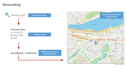
Understanding Forward Geocoding
Forward geocoding is the process of translating structured or unstructured address information into precise latitude and longitude coordinates. By leveraging a database of location data, this method helps map and navigation systems determine exact locations based on inputted addresses.
The Importance of Accurate Address Data in Forward Geocoding
The effectiveness of forward geocoding depends on the accuracy of the parts of an address provided. A complete and correctly formatted address ensures precise geolocation, reducing errors in mapping and navigation.
Key address components include:
Street Name and Number – The primary identifier of a location.
City or Municipality – Essential for narrowing down the location.
State or Province – Helps refine regional accuracy.
Postal Code – Enhances precision by limiting possible location variations.
Country – Crucial for distinguishing similar addresses in different nations.
Applications of Forward Geocoding in Location Mapping
Forward geocoding is widely used across multiple industries to improve mapping and navigation functionalities. Some of its key applications include:
1. Navigation and Routing Services
Navigation apps and GPS systems rely on forward geocoding to convert typed addresses into mappable locations. This allows users to receive step-by-step directions with optimized routes based on traffic and road conditions.
2. E-Commerce and Delivery Services
Online retailers and logistics providers use forward geocoding to ensure accurate deliveries. Address validation before shipment minimizes failed deliveries and enhances customer satisfaction.
3. Emergency Response and Public Safety
Emergency services utilize forward geocoding to pinpoint incident locations quickly. Accurate geolocation helps first responders reach emergencies faster, improving public safety outcomes.
4. Real Estate and Property Management
Real estate platforms integrate forward geocoding to map property listings accurately. Buyers and renters can view available properties based on precise geographic coordinates.
5. Urban Planning and Infrastructure Development
City planners leverage forward geocoding to analyze geographic data for better infrastructure planning. It aids in zoning regulations, traffic management, and public transportation improvements.
Challenges in Forward Geocoding and Address Accuracy
Despite its advantages, forward geocoding faces challenges, particularly when address data is incomplete or incorrectly formatted.
1. Inconsistent Address Formatting
Differences in address formats across regions can lead to geolocation errors. Standardizing address inputs reduces discrepancies in mapping.
2. Ambiguous or Missing Address Components
If an address lacks key parts of an address, the system may return inaccurate or multiple location results. Address verification tools help mitigate these issues.
3. Data Quality and Database Limitations
Forward geocoding relies on extensive location databases. Incomplete or outdated databases can affect accuracy, making regular updates essential.
Improving Forward Geocoding Accuracy
To enhance the reliability of forward geocoding, organizations can implement various best practices:
Address Standardization – Using consistent formats ensures uniformity in geolocation results.
Validation Tools – Automated address verification software corrects errors and fills missing data.
Integration with GIS Systems – Geographic Information Systems (GIS) improve spatial data management and accuracy.
Regular Data Updates – Keeping location databases current ensures precise mapping.
The Future of Forward Geocoding in Location Technology
Advancements in AI and machine learning are revolutionizing forward geocoding. Predictive analytics and automation enhance accuracy, making location-based services more efficient and reliable.
Conclusion
Forward geocoding plays a vital role in location mapping and navigation, transforming address data into usable geographic coordinates. The accuracy of geolocation depends on the completeness of parts of an address, making standardization and validation essential for precision. As technology evolves, forward geocoding will continue to enhance navigation systems, logistics, and urban development, driving innovation in location-based services.
youtube
SITES WE SUPPORT
A Guide to Addresses, Forward Geocoding & In-House Printing – Blogspot
SOCIAL LINKS
Facebook
Twitter
LinkedIn
Instagram
Pinterest
0 notes
Text
GIS Services for Accurate Mapping Solutions
In today’s rapidly advancing world, Geographic Information Systems (GIS) have emerged as a cornerstone for accurate mapping and spatial analysis. Whether in urban planning, disaster management, environmental monitoring, or transportation, GIS services play a pivotal role in delivering precise and actionable insights. These services empower industries to harness spatial data and make informed decisions. This blog delves into the various aspects of GIS services and their importance in providing accurate mapping solutions.
What Are GIS Services?
GIS services involve the collection, analysis, management, and visualization of spatial data to support decision-making processes. They provide tools and methodologies for mapping geographic locations and analyzing spatial relationships. From generating detailed maps to conducting spatial analyses, GIS services offer solutions that cater to diverse sectors, such as:
Urban Development: Designing city layouts and managing infrastructure projects.
Environmental Conservation: Monitoring deforestation, tracking wildlife, and managing natural resources.
Disaster Management: Identifying risk zones, planning evacuation routes, and coordinating rescue operations.
Transportation: Optimizing routes, managing traffic, and planning public transport systems.
Importance of Accurate Mapping Solutions
Accurate mapping forms the backbone of effective GIS services. Inaccurate or outdated maps can lead to poor decisions, inefficiencies, and even catastrophic outcomes. For instance, during natural disasters, precise maps are crucial for planning evacuation routes and identifying safe zones. GIS services ensure that maps are not only accurate but also updated in real time, incorporating the latest spatial data for actionable insights.
Components of GIS Services
GIS services encompass several components that work together to deliver accurate mapping solutions:
1. Data Collection
Data is the foundation of GIS. Spatial data can be collected from various sources, including:
Satellite Imagery: Provides high-resolution images of the Earth’s surface.
Aerial Surveys: Captures detailed geographic data through drones or aircraft.
GPS Devices: Offers precise location-based information.
Field Surveys: Gathers ground-level data for enhanced accuracy.
2. Data Processing
Once collected, raw spatial data must be processed to remove errors and ensure consistency. This involves:
Georeferencing to align data with geographic coordinates.
Data cleaning to eliminate redundancies and inaccuracies.
Conversion into compatible formats for integration into GIS platforms.
3. Spatial Analysis
Spatial analysis helps derive meaningful insights from geographic data. Techniques such as overlay analysis, proximity analysis, and network analysis allow GIS professionals to:
Identify patterns and trends.
Assess relationships between geographic features.
Make predictions based on historical data.
4. Visualization
GIS services excel in transforming complex data into visually appealing and easily interpretable maps and charts. This includes:
Thematic maps that highlight specific attributes like population density or land use.
3D visualizations for urban planning and terrain analysis.
Interactive dashboards that allow users to explore data dynamically.
5. Data Management
Efficient data management is crucial for maintaining the accuracy and relevance of GIS solutions. This involves storing, organizing, and updating spatial data using tools like:
Geographic databases such as PostGIS or ArcGIS Online.
Cloud-based storage for scalable and secure data management.
Applications of GIS Services in Accurate Mapping
GIS services find applications across a multitude of industries, offering unparalleled accuracy and insights. Here are some key areas where GIS is making a significant impact:
1. Urban Planning and Development
Urban planners use GIS to design sustainable cities, optimize land use, and manage infrastructure projects. Accurate maps help planners visualize spatial constraints and opportunities, enabling data-driven decisions.
2. Environmental Monitoring
GIS services play a critical role in tracking environmental changes, such as deforestation, climate change, and pollution levels. By analyzing spatial data, organizations can implement effective conservation strategies and monitor their impact.
3. Disaster Management
In disaster management, GIS services provide critical support by identifying risk zones, predicting the impact of natural calamities, and planning evacuation routes. Accurate mapping helps minimize damage and save lives.
4. Transportation and Logistics
GIS services enable efficient route planning, traffic management, and supply chain optimization. For example, logistics companies can use GIS to reduce delivery times and costs by identifying the most efficient routes.
5. Healthcare and Public Health
In the healthcare sector, GIS services assist in mapping disease outbreaks, planning healthcare facility locations, and analyzing access to medical services. This spatial data is invaluable for public health initiatives and resource allocation.
6. Natural Resource Management
GIS services are extensively used in managing natural resources like forests, water, and minerals. Accurate mapping ensures sustainable resource utilization and helps monitor environmental impacts.
Benefits of GIS Services for Accurate Mapping
Improved Decision-Making: GIS services provide a comprehensive understanding of spatial data, enabling better decision-making.
Cost-Effectiveness: By optimizing resources and operations, GIS services reduce costs in sectors like transportation and urban planning.
Real-Time Updates: Many GIS platforms offer real-time data integration, ensuring that maps and analyses remain relevant.
Enhanced Collaboration: GIS services facilitate collaboration by providing a shared platform for multiple stakeholders to access and analyze data.
Scalability: GIS solutions can scale to accommodate growing datasets and expanding project requirements.
Future Trends in GIS Services
The field of GIS is constantly evolving, with new technologies enhancing the accuracy and usability of mapping solutions. Some emerging trends include:
Artificial Intelligence (AI) and Machine Learning (ML): These technologies are being integrated with GIS to automate data processing, enhance spatial analysis, and predict future trends.
3D Mapping and Visualization: Advanced 3D mapping techniques provide a more realistic representation of geographic data, aiding in urban planning and disaster management.
Cloud-Based GIS: Cloud platforms are making GIS services more accessible, scalable, and cost-effective for organizations of all sizes.
Internet of Things (IoT): IoT devices are generating massive amounts of real-time spatial data, which can be integrated into GIS for dynamic analysis and decision-making.
Augmented Reality (AR): AR is being used to overlay GIS data on the real world, offering innovative applications in navigation and field operations.
Challenges in Implementing GIS Services
Despite their numerous benefits, implementing GIS services comes with its own set of challenges:
Data Quality: Ensuring the accuracy and reliability of spatial data can be difficult, especially when integrating data from multiple sources.
Technical Expertise: GIS services require skilled professionals who understand both the technical and analytical aspects of the field.
Cost of Implementation: High initial costs for software, hardware, and data acquisition can be a barrier for some organizations.
Data Privacy: Managing sensitive geographic data requires robust security measures to prevent unauthorized access.
Conclusion
GIS services are revolutionizing the way we understand and interact with geographic data. By providing accurate mapping solutions, they enable organizations to tackle complex challenges, optimize operations, and drive sustainable growth. As technology continues to advance, GIS services will play an even more critical role in shaping our world. Whether you’re in urban planning, environmental conservation, or transportation, leveraging GIS services can be the key to unlocking new opportunities and achieving your goals.
0 notes
Text
Complete Technical SEO Services in Baltimore, MD | Click Impact SEO
In today’s digital-first world, having a website that ranks well in search engine results isn’t just an advantage—it’s essential. For businesses in Baltimore, ensuring their website is technically optimized is critical to staying ahead of the competition. That’s where Click Impact SEO, a leading technical SEO agency in Baltimore MD, comes in.
Our complete technical SEO services focus on building a strong foundation for your website, enhancing its crawlability, user experience, and search engine performance.
What is Technical SEO?
Technical SEO refers to the process of optimizing a website’s infrastructure to ensure it meets search engine guidelines. It goes beyond keywords and backlinks to address the backend aspects of a website, like:
The goal of technical SEO is to make your website easily accessible for search engine bots while providing an exceptional experience for users.
The Importance of Technical SEO
Failing to invest in technical SEO can limit your website's ability to rank, no matter how great your content is. Here's why technical SEO is essential for businesses in Baltimore:
Enhanced Search Engine CrawlabilitySearch engine bots must crawl and index your site to display it in search results. Technical SEO ensures your website structure is optimized for smooth crawling.
Better User ExperienceUsers expect fast-loading, mobile-friendly websites. Technical SEO addresses issues that could deter visitors, such as slow load times or navigation problems.
Improved RankingsTechnical optimization resolves issues like duplicate content, crawl errors, and broken links that can hurt rankings.
Future-Proofing Your WebsiteAs search engines evolve, technical SEO keeps your website aligned with the latest best practices, such as mobile-first indexing and Core Web Vitals.
Click Impact SEO: Your Trusted Technical SEO Agency in Baltimore, MD
At Click Impact SEO, we specialize in delivering tailored technical SEO services that drive measurable results for businesses in Baltimore and beyond.
Why Choose Click Impact SEO?
Expertise and ExperienceOur team of SEO professionals has extensive experience handling a variety of technical SEO challenges for businesses of all sizes.
Customized StrategiesNo two websites are the same. We analyze your site’s unique needs and design a bespoke technical SEO strategy to maximize its performance.
Proven ResultsAs a leading technical SEO company Baltimore, we’ve consistently delivered results, helping clients achieve higher rankings, more traffic, and improved conversions.
Our Complete Technical SEO Services
At Click Impact SEO, we offer a wide range of services to enhance your website’s technical performance:
Comprehensive Technical Audits:Our in-depth audits uncover any issues preventing your site from achieving its full potential.
Site Speed Optimization:We reduce load times to improve user experience and boost search engine rankings.
Mobile Optimization:With mobile-first indexing, we ensure your site performs flawlessly on all devices.
Crawl Error Fixes:We identify and resolve crawl issues that hinder search engines from indexing your site.
Structured Data Implementation:Adding schema markup helps search engines better understand your site’s content, improving click-through rates.
Secure HTTPS Implementation:A secure website builds trust with users and aligns with search engine preferences.
XML Sitemaps and Robots.txt Configuration:We optimize these files to guide search engine bots effectively through your site.
Baltimore Businesses Thrive with Click Impact SEO
Baltimore is home to a thriving business community, and competition in the digital space is fierce. To stand out, you need a partner who understands the technical complexities of SEO and is dedicated to delivering results. That partner is Click Impact SEO.
With our comprehensive technical SEO services, we ensure your website not only meets but exceeds search engine standards, giving your business the competitive edge it needs.
Get Started with Click Impact SEO
Don’t let technical issues hold your website back. Partner with Click Impact SEO, the trusted technical SEO agency in Baltimore, MD, to unlock your site’s full potential.
Contact us today to learn more about our complete technical SEO services and take the first step toward dominating the digital landscape.
Ready to improve your website's performance? Visit Click Impact SEO's Technical SEO Services and let’s achieve great results together!
0 notes
Text
HIS 5925 Module 8 Makeup
This week’s topic concerning Digital History revolves around the creation of geographical information systems (GIS) and how it implemented more accurate and ethical readings of landscapes and maps. Essentially the introduction of technology into cartography, which allows the conversation of spatial quantitative studies to integrate into the social sciences field. [1] Through a more formal definition of GIS from the Social Science History Association volume 24, the author Anne Kelly Knowles defines the purpose of GIS as a practice that should be directed through a historical lens that converts the archival material into digital form, the material being a geographical site rather than an object. [2] This allows a more dynamic and clear visual evidence in creating spatial arguments, thus increasing the collaborative purpose in digital history.
In providing brief context, the idea GIS first came to play as beginning prototypes to solve the issue in digitizing geographical data in the mid 1960’s. [3] The rigid and limited access to GIS would soon change as the federal government’s concern in mapping a plethora of data, it would then be accessible to research projects and professionals in ryder to have some improvements made in its productions of more geographical data to be preserved. [4] The database is then turned into an accessible tool as technology have infiltrated the average household, even being used in classrooms during the late 1980s. [5] This in turn made GIS a known tool in the historical world. Knowles state, “Using GIS, however, inevitably heightens one’s awareness of geographical relationships, the physical characteristics of places and regions, and the often unmined historical data contained in maps and other geographical sources”. [6] A program progressing into a source that integrates fields of studies and creating interesting complexities in documenting locational history.
The 2002 source from the same author, Anne Knowles, makes an integrated analysis, alongside with various professionals in the digital history field, to discuss the uses and future goals for GIS. Specifically in chapter 1, by David Rumsey and Meredith Williams, there is an alternating discussion of the benefits and setbacks of GIS in relation to traditional historical maps.[7] The article does an exceptional job of laying concerns throughout multiple fields, instead of focusing on their own subjective experience of the database.
An example of beneficial use of the complexities within GIS, is its use of geographical data to essentially fact check or prove the displacement and genocide of the European Jewish population during WWII. The book, Geographies of the Holocaust, exhibits the use of spatial technology around the events surrounding the Holocaust. Specifically for my chapters, “Bringing the Ghetto to the Jew: Spatialities of Ghettoization in Budapest” by Time Cole and Alberto Giordano, provides GIS generated mapping of the displacement and making of ghettos in neighborhoods throughout Budapest. The chapter provides pages upon pages of maps, that even go into specifics of what curfews were set with the additional geographical information in the foot traffics of certain connecting streets. [8] In understanding foot traffic, the information even gave insight on daily activities and what limitations were set on the Jews, further extending the analysis of the Holocaust. [9]
[1] Knowles, Anne Kelly. “Introduction.” Social Science History 24, no. 3 (2000): https://doi.org/10.1215/01455532-24-3-451. 452.
[2] Ibid.
[3] Ibid., 454.
[4] Ibid.
[5] Ibid.
[6] Ibid., 458.
[7] Knowles, Anne Kelly (Ed.). (2002). "Historical Maps in GIS", In Past Time, Past Place: GIS for History. Redlands, CA: ESRI Press. 6.
[8] Cole, Tim, Alberto Giordano, and Erik B. Steiner. “Bringing the Ghetto to the Jew: Spatialities of Ghettoization in Budapest.” In Geographies of the Holocaust. Indiana University Press, 2014. http://www.jstor.org/stable/j.ctt16gzbvn.8. 145.
[9] Ibid., 149.
0 notes
Text
Design as the Key to Achievement in Energy Efficiency and Sustainability

Design is the key to achieving energy efficiency and sustainability in today's world. Be it domestic or commercial, industrial applications-that proper design of a solar panel system makes the difference in its capture and conversion of solar energy to usable power for the benefit of the end-user.
A well-designed solar panel system will reduce electricity bills, cut down the carbon footprint, and is a source of energy for decades. This also brings about the advantages of incorporating GIS mapping services and geotechnical engineering services to make these solar energy projects more accurate and efficient.
Why Designing a Solar Panel System Matters
Ideally, a solar panel system design produces at the maximum of any energy from sources at the lowest costs possible. The designing process generally encompasses knowledge of several factors such as the location, orientation, shading, and the amount of energy required.
The design of the solar panel system cannot be simply mounting panels on a rooftop or plot of land. Instead, it is a calculation for determining energy output for the system, along with sizing and performance efficiency. Weather patterns and local building regulations are also considered, as well as specific needs in terms of energy from the property.
Advances in Solar Panel Projects through GIS Mapping Services
With large-scale solar panel installations, great importance is placed on both planning and execution, mainly because GIS mapping services enable accurate collection, analysis, and presentation of spatial data on which determination of the best site for the installation of solar panels can be based. GIS mapping services can serve the purpose for engineers by allowing them to analyze terrain, land use, solar radiation, and other obstructions like trees or buildings that might affect the sunlight reaching the plant.
GIS is principally applied in assessing environmental impacts apart from helping abide by the local authorities' regulations. This service helps to make the design of a solar panel system much streamlined by giving the identification of layouts highly efficient for the panels. By reducing the time of installation, it minimizes the chances of expensive mistakes.
Geotechnical Engineering Services: Construction on solid foundation
Another vital component of solar energy projects is geotechnical engineering services. These services are indispensable for the analysis of soil conditions where the panels will be installed - on the rooftop or on the ground- provide pertinent information in terms of soil stability, bearing capacity, and potential hazards.
One of the prime reasons is the understanding of geotechnical conditions at the site, which facilitates a structurally safe and sound solar panel system. Poorly designed foundations or unsuitable soil conditions may become a major cause of failure of the system, costly repairs, or even worse - a catastrophic collapse.
Integration of design for a solar panel, GIS, and geotechnical expertise
The disciplines of solar panel system design, GIS mapping service, and geotechnical engineering services lead to highly efficient, reliable, and long-lasting solar energy solutions. Each aspect of the installation of solar panels is optimized for performance and safety with these disciplines together.
In the new push for sustainability, a fit and efficient design for the solar panel system is fundamental. The growing demand for renewable sources of energy will, therefore, mean that specialized services in solar projects will form the key creating energy solutions that truly last.
0 notes
Text
OpenDialog and Open GI - Revolutionizing Insurance with AI
Join the newsletter: https://avocode.digital/newsletter/
Introduction to the Partnership
A groundbreaking collaboration is set to redefine the insurance industry. OpenDialog has partnered with Open GI to leverage the power of automation and conversational AI, promising to revolutionize the way insurance brokers operate. This strategic alliance aims to bring efficiency, streamlined processes, and improved client interactions to the fore, all while maintaining the human touch that is so crucial in the insurance sector.
The Role of OpenDialog
OpenDialog is a trailblazer in conversational AI, offering advanced chatbots and AI-driven platforms that enable natural language processing and seamless communication. Their solutions focus on enhancing customer experiences by providing intuitive, human-like interactions.
Key Features of OpenDialog
**Natural Language Understanding:** OpenDialog’s AI can comprehend and process human language with remarkable accuracy, making interactions more fluid.
**Contextual Conversations:** The platform can maintain context across multiple exchanges, ensuring that conversations feel coherent and logical.
**Scalability:** Designed to grow with the business, OpenDialog can handle an expanding number of interactions without compromising performance.
Open GI’s Expertise in Insurance Software
Open GI, a leader in insurance software, specializes in providing comprehensive IT solutions tailored for insurance brokers and agents. Their systems are designed to streamline workflows, enhance data management, and support decision-making processes.
Core Offerings of Open GI
**Broker Management Systems:** Sophisticated platforms for managing client data, policies, and financial information.
**Data Analytics:** Tools that assist brokers in making informed decisions based on comprehensive data analysis.
**Compliance Solutions:** Software that helps brokers adhere to regulatory requirements, minimizing risks and ensuring legal compliance.
Synergy: Integrating Conversational AI with Insurance Software
The integration of OpenDialog’s conversational AI with Open GI’s robust insurance software is set to deliver unparalleled benefits to the industry. This synergy aims to transform traditional methods, bringing about a new era of efficiency and client satisfaction.
How the Integration Works
The collaboration will see OpenDialog’s AI seamlessly embedded into Open GI’s systems. This will allow brokers to:
**Automate Routine Tasks:** Tasks such as data entry, policy management, and customer inquiries can be automated, freeing up brokers to focus on more complex issues.
**Enhance Client Interactions:** AI-driven chatbots can provide instant responses to client queries, offering 24/7 support and improving overall client satisfaction.
**Gain Insights from Data:** Leveraging AI for data analysis enables brokers to gain deeper insights into client behaviors and preferences, facilitating more personalized services.
Real-World Applications
Imagine a client needing assistance with policy renewal. Instead of waiting for office hours to speak with a broker, an AI chatbot can handle the request instantly. It can provide information, process the renewal, and update records in real-time. This not only enhances the customer experience but also ensures that the broker's system is up-to-date with minimal manual intervention.
Benefits for Insurance Brokers
The integration brings a host of advantages for insurance brokers, making their operations more streamlined and productive.
Operational Efficiency
Automating repetitive and time-consuming tasks allows brokers to allocate their time and resources more effectively. This results in:
**Reduced Operational Costs:** Less manual work translates to lower labor costs.
**Improved Accuracy:** Automation reduces the risk of human error, ensuring that client information and policy details are accurate and up-to-date.
Enhanced Customer Satisfaction
With AI handling basic inquiries and routine tasks, brokers can deliver faster and more efficient services. This leads to:
**Better Response Times:** Clients receive immediate support for their queries, improving their overall experience.
**Personalized Services:** Brokers can focus on providing tailored advice and solutions, adding value to their client relationships.
Future Prospects
The partnership between OpenDialog and Open GI sets the stage for future innovations in the insurance sector. As technology evolves, we can expect further enhancements in AI capabilities and software solutions, driving even greater efficiencies and client satisfaction.
Continued Innovation
The focus on continuous improvement and innovation means that insurance brokers will always have access to the latest tools and technologies. This partnership is not just about meeting today’s needs but also about preparing for tomorrow’s challenges.
Expanding Scope
The potential applications of conversational AI in the insurance industry are vast. From customer service to underwriting and claims processing, the integration of AI is poised to transform every aspect of insurance brokerage.
Conclusion
The alliance between OpenDialog and Open GI marks a significant step forward in the insurance industry. By combining the strengths of conversational AI and comprehensive insurance software, they are set to revolutionize how brokers operate, benefiting both brokers and clients alike. This partnership signifies a move towards a more efficient, responsive, and technologically advanced insurance landscape.
Want more? Join the newsletter: https://avocode.digital/newsletter/
0 notes