#spatial analysis
Explore tagged Tumblr posts
Visit Tumblr Blog
Explore Tumblr blogs with no restrictions, modern design and the best experience.
Last Seen Tumblr Blogs


Fun Fact
Tumblr’s reach among the 26-to-35-year-olds in the US is 11%.
Text
Lefebvre's (1974) Spatial Triad
[Direct excerpts]
Spatial Practice, which embraces production and reproduction, and the particular locations and spatial sets of characteristic of each social formation. Spatial practice ensures continuity and some degree of cohesion. In terms of social space, and of each member of a given society’s relationship to space, this cohesion implies a guaranteed level of competence and specific level of performance.
Representation of space, which are tied to the relations of production and the ‘order’ which those relations impose, and hence the knowledge, to signs, to codes, and to ‘frontal’ relations.
Representational spaces, embodying complex symbolisms, sometimes coded, sometimes not, linked to the clandestine or underground side of social life, as also to art (which may come eventually to be defined less as a code of space than as a code of representational spaces).
Spatial Practice: The spatial practice of a society secretes that society’s space; it propounds and presupposes it, in a dialectical interaction; it produces it slowly and surely as it masters and appropriates it. From the analytic standpoint, the spatial practice of a society is revealed through the deciphering of its space.
Representations of Space: conceptualized space, the space of scientists, planners, urbanists, technocratic subdividers and social engineers, as of a certain type of artist with a scientific bent – all of whom identify what is lived and what is perceived with what is conceived. This is the dominant space in any society (or mode of production). Conceptions of space tend, with certain exceptions to which I shall return, towards a system of verbal (and therefore intellectually worked out) signs.
Representational Space: space as directly lived through its associated images and symols, and hence the space of ‘inhabitants’ and ‘users’, but also of some artists and perhaps of those, such as a few writers and philosophers, who describe and aspire to do no more than describe. This is the dominated – and hence passively experienced – space which the imagination seeks to change and appropriate It overlays physical space, making symbolic use of its objects. Thus representational spaces may be said, though again with certain exceptions, to tend towards more or less coherent systems of non-verbal symbols and signs.
Citation/Reference
Lefebvre, H. (1974/1991). The Production of Space. Wiley-Blackwell.
pp. 33-39

2 notes
·
View notes
Text
youtube
TOMORROW. (i'll be there to chat and answer questions, etc. hope to see you there!)
#silent hill#silent hill 4#video essay#spatial analysis#analysis#horror#survival horror#horror game analysis#horrorgameanalysis#horror game#silent hill 4: the room#henry townshend needs to get a personality#Youtube
4 notes
·
View notes
Text
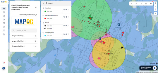
How GIS Helps in Identifying High-Growth Areas for Real Estate Investment
In an ever-changing real estate landscape, identifying areas poised for rapid development isn't just a competitive advantage—it's a necessity. Traditional methods of forecasting growth often fall short in addressing the complex interplays of infrastructure, demographics, and access to essential amenities. That's where Geographic Information Systems (GIS) step in as a transformative force.
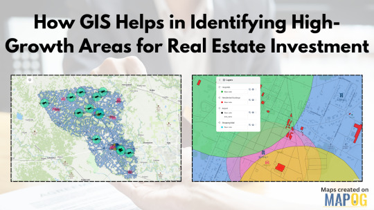
GIS as the Eye Behind Data-Driven Real Estate
GIS technology allows users to visualize and analyze layers of geographic and statistical data all in one view. From traffic congestion and transportation routes to proximity to hospitals, schools, malls, and airports—all of this can be layered spatially to make more informed investment decisions. For real estate developers, this is more than just data; it's a dynamic decision-making tool.
By using GIS, stakeholders can map out locations with strategic access to critical infrastructure. Suppose you're analyzing a city for future residential projects. You could create buffers around public transit lines, shopping centers, and educational institutions to isolate high-potential zones. These buffers offer clarity where raw data often fails to paint the full picture.
Solving the Real Estate Guesswork
One of the biggest pain points in real estate is uncertainty: will a particular neighborhood rise in value? Will upcoming infrastructure really influence demand? GIS helps answer those questions by showing not just what exists, but how it interacts across space and time. For instance, you could track development permits over time or visualize environmental constraints like flood zones or green cover. These insights are crucial for mitigating risk and spotting overlooked opportunities.
Industries like urban planning, government housing departments, logistics, and commercial development firms increasingly rely on GIS to plan smarter. Even small-scale investors are catching on, thanks to platforms that simplify GIS applications into more user-friendly formats.
One Platform, Many Possibilities
Some mapping tools now let you not only import transportation and amenities data but also define your area of interest, set proximity buffers, and drop pins for future projects. You can even share interactive maps with teams or stakeholders. One such example is a GIS platform like MAPOG, which simplifies the entire GIS workflow from analysis to visualization without needing deep technical skills.
Whether you're evaluating urban corridors for commercial hubs or scoping out suburban areas for housing, GIS offers the clarity you need. Try exploring platforms like MAPOG if you're looking for a seamless way to start.
#realestateinvestment#gis#mapog#gismapping#smartcities#urban planning#urban growth#mapping#data visualization#spatial analysis#propertydevelopment
0 notes
Text
Mastering QGIS Desktop 3.34 LTR: From Beginner to Pro.
English Video tutorial, just for $9.99 (NORMAL price $19.9). Get it once and you will get endless access right.
Unlock the full potential of QGIS Desktop 3.34 LTR! This comprehensive guide takes you from the basics to advanced spatial analysis, helping you master GIS techniques, data visualization, and automation with Python. Whether you're a beginner or an experienced user, this book will elevate your GIS skills.
#QGIS 3.34#QGIS tutorial#GIS software#spatial analysis#QGIS Python#mapping software#open-source GIS#QGIS for beginners
0 notes
Link
#Population dynamics#Spatial analysis#Geographic information system#Zamboanga Sibugay province#Urbanization trends
1 note
·
View note
Text
Exploring Local Communities Through Carmel Zip Codes

Credit: Image by Republica | Pixabay
An Overview of Carmel Zip Codes and What They Offer
Imagine moving to a new city or planning a trip to an unfamiliar territory; without clear guidance, you may waste time searching for activities that match your interests. Well, the unsung heroes of geographical organization are zip codes! If you wish to explore the coastal area of the Monterey Peninsula and the beautiful Carmel-by-the-Sea, break it down into manageable parts to find what you're looking for with ease and precision. Here's an in-depth look at notable Carmel zip codes and what they offer.
What Are The Carmel Zip Codes?
Carmel Village itself and its surrounding areas are predominantly within the 93921 zip code. The more remote parts, such as Carmel Highlands and Carmel Valley, are zoned under 93923 and 93924 zip codes, depending on the specific area. These Carmel zip codes mark neighborhoods and districts and showcase unique lifestyles and attractions.
Why Use Carmel Zip Codes When Exploring?
Carmel’s zip codes help visitors and residents explore the area, understand its geography, and discover what each part offers.
Pinpoint Diverse Neighborhoods Carmel zip codes represent a unique aspect of living, from the bustling charm of downtown to the quiet luxury of cliffside communities or the sun-drenched appeal of inland areas.
Tailor Experiences to Preferences Carmel zip codes can guide you to areas with attractions that match your interests. Love the beach? Focus on 93921. Prefer vineyards and open spaces? Head to 93924.
Ease Real Estate Searches Homebuyers can use Carmel zip codes to target specific lifestyles, property types, and price ranges. These codes help streamline the search for their dream home, whether they seek a coastal cottage or a sprawling valley estate.
Discover Hidden Gems Carmel zip codes often include lesser-known spots that might not appear in general guides. For instance, 93922 offers serene hiking trails and stunning ocean views less heavily marketed than downtown Carmel's attractions.
Simplify Navigation Exploring the Carmel region using zip codes makes it easier to navigate, whether you're planning a trip or relocating.
Get To Know Carmel Zip Codes
93921: Carmel-by-the-Sea’s Storybook Charm
The 93921 Carmel zip code is inseparable from charming downtown and the surrounding neighborhoods. This area offers charming scenery of fairy-tale cottages, small-styled shops, and beautiful artistic galleries. Roads are easy to walk, and the neighborhood environment creates a village vibe, making it suitable for people who have retired, families, and working people.
Homes in this area range from small bungalows to multimillion-dollar estates. Dining options are abundant. Parking and home prices can be challenging, but the unique charm outweighs the drawbacks for many.
93923: Coastal Elegance of Carmel Highlands
93923 zip code covers Carmel Highlands, which is located to the south of Carmel-by-the-Sea. This area is affluent, with cliff homes and villas with breathtaking vistas of the Pacific Ocean from their balconies. Some rank among the most costly in the region and cater to luxury buyers.
Carmel Highlands appeals to those seeking tranquility and high-end living. The atmosphere is rural, the location is relatively secluded but it is only a few minutes’ drive from Carmel town proper. Places of interest include Point Lobos State Natural Reserve which offers trails as well as wildlife viewing opportunities.
93924: Carmel Valley’s Vineyards
Carmel Valley is famous for its sunny weather and wine-country vibes. Bernardus and Holman Ranch wineries are among the many that make this area a wine-lover destination. In addition to vineyards, golf courses, and equestrian properties define the area.
Homes in 93924 often have large lots, perfect for anyone seeking a quiet retreat. They are less expensive than coastal Carmel but require a longer commute to the beach and shopping centers.
93920: Big Sur’s Rugged Beauty
The 93920 zip code includes Big Sur, which is famed for its stunning topography along the edges of the ocean. Due to its aforesaid features, this region is perfect for those who are in search of solitude and stunning landscapes. Many houses rest at the cliff edges affording extraordinary views of the sea.
Big Sur is a haven for artists, nature enthusiasts, and those who crave privacy. However, living here means limited access to amenities. Residents often travel to Carmel or Monterey to shop and dine.
93940: Monterey’s Urban Convenience
93940 includes Monterey. Though not part of defined Carmel zip codes, it is definitely close. This area is ideal for those who want proximity to downtown Monterey, Cannery Row, and the Monterey Bay Aquarium.
Homes here range from historic Victorians to modern condos, catering to various budgets. The area boasts excellent schools, parks, and family-friendly activities. Monterey’s vibrant cultural scene and stunning bay views make it a desirable destination.
93950: Pacific Grove’s Coastal Retreat
The 93950 zip code covers Pacific Grove, located just north of Carmel. This charming seaside community features historic homes, coastal trails, and a laid-back lifestyle.
The Lovers Point Park and Asilomar State Beach are favorite spots for outdoor activities. Homes here are more affordable than those with Carmel zip codes, attracting families, retirees, and first-time buyers.
93953: Exclusive Pebble Beach Living
Pebble Beach is an internationally renowned community. This area is synonymous with prestige and is known for its luxury estates and world-class golf courses. Residents enjoy gated privacy, stunning ocean views, and access to the famous 17-mile Drive.
Pebble Beach is perfect for golf enthusiasts and affluent buyers looking for exclusivity. The area’s top-tier schools and peaceful surroundings also attract families. With high property values and HOA fees, living here requires a significant financial commitment. However, for those who can afford it, Pebble Beach offers unparalleled luxury.
93955: Affordable and Accessible Seaside
Seaside is just north of Monterey. This area is one of the more affordable options near Carmel zip code addresses. It is a practical and budget-friendly option for coastal living.
It has a mix of older homes, newer developments, and some apartments. It is close to California State University Monterey Bay and Fort Ord National Monument.
Wrap Up
Carmel’s zip codes offer distinct lifestyles, from rugged beauty to unparalleled luxury. Whether you prioritize affordability, exclusivity, or proximity to nature, the Monterey Peninsula has something for everyone. Understanding what each zip code offers can help you find the perfect fit for your needs.
Visit https://heinrichbrooksher.com/zip-code-map/ to explore the unique neighborhoods defined by Carmel zip codes and find your perfect coastal home today.
Explore the stunning coastal neighborhoods, lifestyles, and attractions with our complete Carmel zip code guide!
#Community Information#Real Estate Blogs#Real Estate#Carmel CA Real Estate#Carmel CA Realtor#Carmel CA Homes#Carmel CA Neighborhoods#Carmel CA Communities#Carmel-by-the-Sea ZIP Code Map#Carmel CA Postal Codes#Monterey County ZIP Code Map#Carmel 93923 Boundary Map#93921 Carmel Downtown Map#California ZIP Code Locator#Carmel Neighborhood Maps#Carmel CA Real Estate Map by ZIP Code#Zip Code Boundaries#Mapping Carmel CA#Carmel CA Demographics#Geographic Information System#County Map#Municipalities#Census Data#Urban Planning#Demographics#Cartography#Spatial Analysis#Geographic Data Visualization#Boundary Mapping
0 notes
Text
me fr
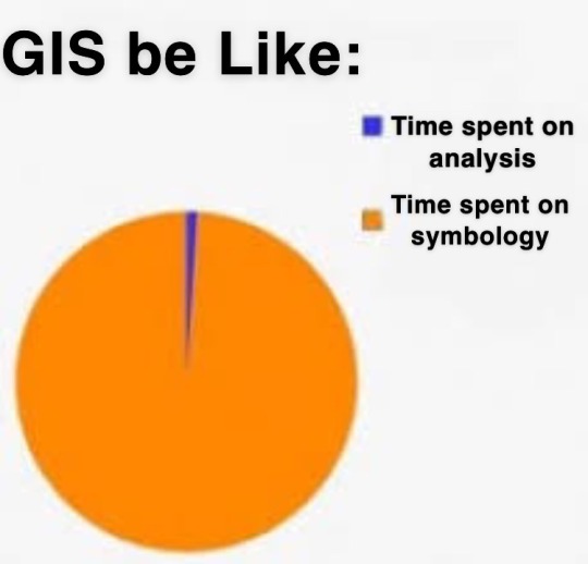
why is the default symbology the ugliest thing ive ever seen like Who want a map that looks like That
57 notes
·
View notes
Text
absolutely fuckin. riveting insight from the GIS textbook. thank you so much. also great job using language like a human person, really nailed it there.
#now it is the migration season for the older criminals#once they develop greater mobility they can travel en masse to the central business district#where they gather for their annual Crime Displays#(I've started writing CRIME MENTION!!! in my lecture notes every time ~crime analysis~ gets brought up as a use for GIS)#(literally at least once almost every. damn. week.)#(part of this class is supposed to be like. developing a critical eye toward irl equity dynamics with spatial analysis)#(Y'ALL. CAN WE START WITH THE FUCKING TEXTBOOK.)#(Official How To ArcGIS Book from Official ArcGIS Developer Organization =/= good critical pedagogy)#(but don't worry; it's also not good at teaching (me) how to use the program too!)#James liveblogs grad school#hi. I'm in. a goddamn mood this week. apparently.#stabbing mood. many stabbings.
9 notes
·
View notes
Text


6th of September 2023
🇩🇰 I love to bike everywhere! My butt hurts tho.
Learning a lot about remote sensing and spatial urban analysis this term 🍀
#studyblr#geography#study#desk#motivation#uni#mine#study setup#studying#study aesthetic#spatial studies#Remote sensing#analysis#studyspo#Copenhagen
54 notes
·
View notes
Text
Elden Ring: a cross between Absurdism and Surrealism
Upon reflection, I'd say the genre of the base game is pretty decently rooted in the theatre of the absurd. One of the main themes of that movement being the failure of language to clearly communicate ideas, leading to confusion and loss of direction.
Skimming over some articles on traditional absurdist literature, the three responses to the absurd are termination of the self (Frenzy Flame), turn to religion or some other higher purpose (any Elden Lord end), or rebel against the absurd. Which is to say embrace and accept the profound meaninglessness and go on anyways (Age of Stars). The Blessing of Despair is perhaps also an acceptance of the absurd, only it's with bitterness from a more narcissistic nihilism viewpoint when contrasted again Ranni's path. Space is cool, stars are cool. Even worms and dirt are cool, but not with the attitude the Dungeater has.
The DLC is something else entirely, and in fact I'd speculate that it's a genre shift from absurdism to surrealism. The aesthetic framing of the cocoon entry point itself was a play on Salvador Dali's “Geopoliticus Child Watching the Birth of the New Man” so the inspiration is right there in the open. There is indeed a difference between those two movements, as described by someone who has read the relevant literature more thoroughly and recently than I have:
"Absurdist writing focuses on the inherent purpose of life being elusive or questioned, can use dark humor to comment on the human condition, and explores themes of existentialism and purposelessness. Surrealism is marked by disjointed and occasionally fantastic imagery, irrational juxtaposition, and can be dreamlike"
Notably, the Shadowlands is another contrast against the Age of Stars in that it's a dead end that reflects upon the motifs if the past but offers no path forwards. It examines the ascent to "God and Lord" at a high point of the map and the Frenzy at the lowest depth and all of the other bits sandwiched between those two extremes.
Basically, the Lands Between is absurdism with the aesthetics of surrealism and the Shadowlands seem to show what it means to dive into surrealism while maintaining the theme of breakdown of communication that is characteristic of absurdism. Surrealist writing would be vague and cryptic and evocative of imagery. Absurdist writing is about people saying perfectly coherent words, but still talking past each other because they are asking the wrong questions and can't establish a common ground. In this sense "clarity" is a trap - the truth that you think you understand is not always what was said.
Similar to Demon's Souls, Dark Souls, and Bloodborne, the gothic medieval fantasy is a thin veneer for whatever philosophical or artistic movement FromSoft feels like exploring at the moment.
#Elden ring#shadow of the erdtree#analysis of art design#media analysis#I'm personally fond of 'Rosencrantz and Guildenstern are Dead' although I read 'Zoo Story' for a class#There are just so many layers of communication in visual and spatial and auditory and real world context in Elden Ring#Much more going on than dialogue and item descriptions
14 notes
·
View notes
Video

flickr
DSC_0333 Architectural Space (Collage) by Russell Moreton Via Flickr: russellmoreton.blogspot.com russellmoreton.tumblr.com
#collage#architectural#interior#photography#fragments#layers#ruins#material#place#site#reading#spatiality#working process#design#architecture#visual art#speculative#subjective#analysis#construction#making#Russell Moreton#visual fine art#spatial practice#research creation#ecology of experience#useless flickr uploader#flickr
2 notes
·
View notes
Text
Fibiger, M. Q. (2023). What Are Religious Hotspots? An Introduction. Numen, 70(1), 1-16.
DOI: https://doi.org/10.1163/15685276-12341673.
Abstract
This introductory article outlines the meanings behind and the reasons for suggesting “religious hotspots” as a new analytical concept in the study of religion. The idea of suggesting this concept is not to replace others – for instance, a pilgrimage site, a religious place, a supernatural place, or a storied place – but to broaden the perspective and to emphasize the dynamic, multidimensional, and relational aspects of place, not least concerning how a religious place can be a hotspot for some and a cold one for others, but also how a place can change from being a hotspot to a cold spot and vice versa. Being a heated place, a religious hotspot can also have an unintended effect on people being there. They can either become “infected” by or “cured” of a feeling of religious or spiritual belonging. The concept is a contribution to the growing interest in space and place when analyzing religion, in recognition of how a landscape or a particular religiously legitimized site can be an important element in collective cultural, social, and political meaning-making.
6 | Precis
A religious hotspot is a religiously or spiritually legitimized place, and it can be a goal for religious tourism as well as pilgrimage. It can be classified as a supernatural or energetic place, meaning that the supernatural or the thaumaturgical is understood as being present in one way or another, but is perceived in multiple ways as long as it is not inscribed in a particular tradition. When it becomes fixed, it can become a place of pilgrimage. In other words, a religious hotspot can be difficult to define. It is context-related and depends on the circumstances in which it is understood and by whom. It can therefore have multiple meanings. Concurrently, it is also a place that attracts people because it is understood as producing meaning: religious or spiritual, or cultural and social in terms of identity-making. This means that a religious hotspot can have several definitions, nuances, presentations, and connotations, which is not only important in relation to modern religious hotspots but also when trying to understand the dynamics of a place.
#Religious Studies#sacred spaces#spatial analysis#spatial theory#space and place#academic literature#research#religious hotspot
2 notes
·
View notes
Text
ok im back to hating everything. My prof really did NOT do a good job this semester I feel completely unprepared and… I’m aware that what I’m trying to do is so much more complex than what we covered in class but normally I don’t have problems to scale things up like this but I think I severely underestimated the complexity of what I’m trying to model. Lol. god I’m so scared bc a huge part of my research hinges on me figuring this out and I have NO ONE I can ask bc no one works with QGIS on this scale so help me fucking g-d lmaoooo 😭
#I’ll be alright I’ll be ok#I’m just venting#I do know people who work with it but they’re acquaintances and it’ll be weird if I ask for help out of the blue#I WILL ask them but not for this assignment cos it’s due on Wednesday 😂#it’s just a little trial run so I’m ok bc I think I have enough data for that#I’m just gonna do some raster analysis tmrrw bc I’m good at that#and then hopefully he won’t notice that I have no fucking clue how to interpret the spatial lag model lololol#I just don’t fucking understand what my output is tbh#like. 😭 too many variables and they’re so weirdly spatially distributed but I don’t understand where that comes from bc#they should be clustered bc I RECORDED them as clusters myself#is it bc the stupid model doesn’t understand that there’s 5 clusters? and it treats it like they are one giant cluster?#I don’t know! and neither does the fucking internet apparently! 😂#UAGGHHHH ok time to go to bed#shut up Sam
2 notes
·
View notes
Text
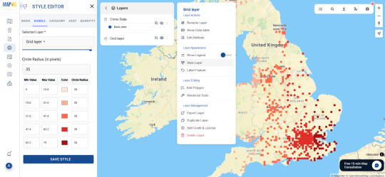
Mapping Crime Hotspots Using Grids and Heat Bubble Tools
Crime analysis is one of the most critical areas where Geographic Information Systems (GIS) have made a significant impact. With urban areas expanding and public safety being a major concern, law enforcement and municipal authorities are turning to geospatial tools to detect patterns and predict potential crime zones. But what happens when raw crime data is overwhelming or scattered? That’s where grid mapping and visual heat analysis step in—offering clarity, precision, and actionable insights.
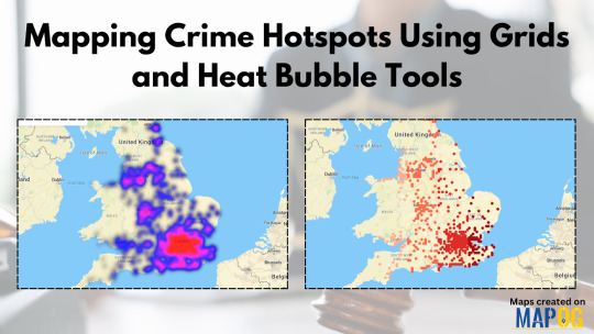
In cities where thousands of crime records accumulate monthly, manual analysis isn't practical. The real challenge lies not just in collecting data but in making sense of it quickly and visually. A platform like MAPOG lets you upload crime data from Excel or CSV files, generate grid overlays to segment zones, and apply heat bubble visualization to highlight areas of concern. It’s an effective and simple way to convert cold statistics into something intuitive and readable.
Why GIS is Crucial in Crime Analysis
GIS doesn’t just plot points on a map; it contextualizes the data. Whether it's tracking burglary incidents across a city or analyzing patterns of assaults in specific neighborhoods, GIS allows users to filter events by time, frequency, and type. Over time, this reveals clusters and trends that can inform preventive strategies. For instance, if a neighborhood shows consistent activity near schools or parks during certain hours, police patrols can be adjusted proactively.
Several industries benefit from this type of spatial intelligence. Public safety agencies rely heavily on it, but so do urban planners, academic researchers, and even insurance companies assessing neighborhood risk profiles. When used in real-time or near real-time, GIS-based crime analysis can influence policy decisions, budget allocations, and community engagement strategies.
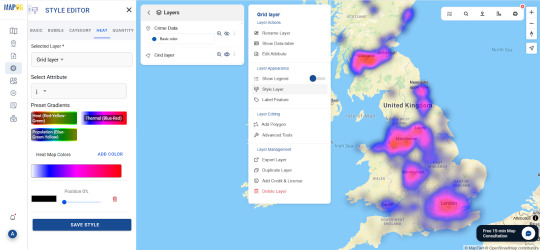
Data-Driven Visualizations: The Power of Grids and Bubbles
Grids simplify large datasets by dividing geographic space into uniform cells. This not only organizes information but also reveals spatial patterns you might miss in traditional pin maps. When layered with heat bubble tools, each cell or hotspot visually reflects the volume or severity of incidents. High-density areas stand out, drawing immediate attention to potential problem zones.
Platforms that offer both grid and heat mapping in one interface save time and reduce errors from switching between tools. By using the preview and share features, users can also collaborate or present their analysis to decision-makers without exporting files or relying on additional software. If you're looking for a solution that combines upload features, grid generation, and heat visualization, it's worth exploring this kind of mapping system. You can try one MAPOG and experiment with your own dataset.
Conclusion
GIS technology is transforming the way we approach public safety, offering clear visual narratives in a sea of raw numbers. Whether you're an analyst, policymaker, or student exploring spatial intelligence, crime hotspot mapping using grids and heat tools provides both insight and foresight. Want to see how this works for your own city or study? Consider testing out a mapping workspace that enables data uploads, grid creations, and interactive visual sharing.
0 notes
Text

Mastering QGIS Desktop 3.34 LTR: From Beginner to Pro. Unlock the full potential of QGIS Desktop 3.34 LTR! This comprehensive guide takes you from the basics to advanced spatial analysis, helping you master GIS techniques, data visualization, and automation with Python. Whether you're a beginner or an experienced user, this book will elevate your GIS skills.
English Video tutorial, just for $9.99 (NORMAL price $19.9). Get it once and you will get endless access right. Visit:
#QGIS 3.34#QGIS tutorial#GIS software#spatial analysis#QGIS Python#mapping software#open-source GIS#QGIS for beginners
0 notes
Text
actually it is, its called an equal-area projection:
there are 3 core properties (there are more but we're not going there) that a map can represent about a physical space: shape, area, and distance. these 3 properties can be picked and chosen while deciding how to project your map but its impossible to have all 3 because, well, like said above, Earth is a spheroid.
a map that preserves shape (mostly at small scales) is called conformal, which is what the Mercator projection is, and they are mutually exclusive with equal area maps. there's also equidistant maps which preserve distance, but they typically only function at a small scale across one meridian. Mercator is also what you'd call a true direction map, meaning that unlike the equal area example above, the landforms are arranged essentially the way they would be on a globe. in other types of projections, the angles are a bit off
so, Earth being round doesn't mean its not possible to project a map where the sizes are accurate. it just means that maps that have accurate areas sacrifice the accuracy of shape and/or distance
i know this probably wasnt the question asked, they may have been more interested in the impossible map that normalizes all 3 of those constants, but i feel like projections like this that have mathematic or scientific appeal but not practical or aesthetic appeal don't get the appreciation they deserve.
In their defence, a lot of it is sand.
40K notes
·
View notes