#GIS image processing services
Explore tagged Tumblr posts
Visit Tumblr Blog
Explore Tumblr blogs with no restrictions, modern design and the best experience.
Last Seen Tumblr Blogs


Fun Fact
Forty percent of Tumblr users are between the ages of 18 to 25.
Note
Can you tell us anything about the Creature Commandos? I read a brief blurb about them in a book of "Weird War Tales" with other stuff like the GI Robot and the Boy Commandos, but trying to google anything on them just leads to debates as to whether or not they were actually supernatural or some kind of science project.

Oh dammit, James Gunn's little Inglorious Bastards-esque cartoon just came out didn't it? Jokes on you guys though, I actually ordered and read the appropriate books ahead of time! You're not slick!/s
Thank you for providing the image for this one so I don't have to go looking for it. (I truly hope you did not watch the old TV movie this was made for though. My god this poster it the best part of it)
To answer the most pressing question, they're a science experiment. Buckle in because if you thought your opinion of the US Army could not get any lower!
The Creature Commandos were formed in 1941 under the auspices of an outfit known as Project M which was the pot the US Army threw money into with the expectation it would use them to come up with super weapons to end the Nazi threat with no oversight or ethical constraint. They were responsible for the construction of G.I Robot as you mentioned and one of their failed experiments even granted New York native Joan Dale the powers she would use to become Miss America.
The Commandos specifically were the brainchild of one Dr. Myron Mazurksy, a real mad scientist type with the pet theory that the tales of monsters and ghouls making up the bulk of human mythology were the triggers for an kind of evolutionary fear, his hypothesis was that altering subjects through chemical and surgical methods to resemble these monsters of legend would give them an edge on the battlefield. (Of course we know now that these stories are not psychological misinterpretations at all but instead tales of actual beings that really do exist)
The Creature Commandos were made up of four founding members:
Private Warren Griffith was diagnosed with psychological lycanthropy and so was remanded into Project M's custody where he was surgically altered into and actual wolf man with very little conscious control of the time of his painful metamorphosis. He had committed no crime other than being considered psychologically unfit for service.
Pilot Officer Vincent Velcoro, a member of the Royal Air Force convicted of high treason for striking a well connected superior officer. Remanded into American custody without any due process under British military law he was given the choice of a 30 year sentence or experimentation which turned him into a human vampire, forced to drink blood at least once a day and only able to stomach consuming raw meat.
Private Elliot "Lucky" Taylor, a newly minted marine who was nearly killed by a land mine during a war gaming exercise. Surgically reconstructed by Project M his vocal cords were severed by the procedure, his family was told he was KIA and Taylor himself was never consulted about the procedure nor was he allowed to leave after the fact. Again he had committed no crime and was not even unfit for service, simply fed into the mill for the sake of "progress"
and Dr Myrra Rhodes who, when operating upon a wounded soldier within Project M's compound was mutated by a poorly secured batch of mutagen chemicals, transformed into a living medusa. She was also unable to leave military custody and was listed as KIA, losing her entire life due to Project M's negligence.
They were placed under the command of one Lieutenant Matt Shrieve who noted in his later unearthed war journal a personal loathing for his "freakish" subordinates whom he treated with inhuman disdain. Providing for their needs only reluctantly and below the standards of what they would have received in a brig back home. They were sent on what were, frankly, suicide missions, managing to survive time and again based on good luck and the members' trust in one another above all.
A truly demonstrative directive, unearthed by a freedom of information request submitted by their families well after the fact showed that the Creature Commandos were under command from the highest echelon that their existence be kept an absolute secret from the All Star Squadron or any of its members. A personal note, written by a redacted command officer at the bottom of the ledger opines
"The long underwear freaks would just get their bleeding hearts in a twist anyway."
Meaning that the army specifically kept the Commandos a secret from the Squadron, KNOWING that the Squadron would object to the less than human conditions and expectations of the Commandos and most likely would have seen to their emancipation under Squadron protection.
As the war drew to a close, the Commandos were marked for execution by firing squad. No trial or crime was ever given as reason. "Spared" from execution they were sent in a rocket toward the then ongoing battle of Berlin to do some final "good" or die trying.
Their presence is not noted at the battle and their bodies, or indeed their trails have never been found. Make of that what you will.
#dc#dcu#dc comics#dc universe#superhero#comics#tw unreality#unreality#unreality blog#ask game#ask blog#asks open#please interact#worldbuilding#creature commandos#patchwork#wolfpack#dr medusa#vincent velcoro
47 notes
·
View notes
Text
Liver transplantation.
The one time you might actually want cancer.
Why? Because having a primary liver cancer bumps you up on the liver transplant list. But it can't just be any cancer - there's a criteria for acceptable cancer burden for adult liver transplant, which is known as Milan Criteria. Essentially one big tumor smaller than 5 cm or 3 small tumors less than 3 cm each. The tumor can't have left the liver either aka metastasis. However if it's too small (<2 cm ), you don't get priority listing for having that cancer. Kind of like Goldilocks - the tumor has to be just right.
Now first off, you almost never get a primary liver tumor aka hepatocellular carcinoma (HCC) without something wrong in the liver in the first place.
This is usually Cirrhosis aka fibrosis of the liver, which can be caused by Hepatitis C or more commonly drinking too much alcohol too often. The liver fails cause its cells are dead or dying, and the resulting scarring prevents blood from your GI tract from returning properly to your systemic blood. This pseudo-blockage results in fluid backing up in your body, resulting in ascites (fluid in the belly) and pleural effusion (fluid in the lung space) and generalized soft tissue swelling.
The body tries to compensate for this by making alternate paths. Problem is the liver is also a filter, and bypassing the filter through an alternate path affects the brain - a common symptom is confusion and sometimes coma in these patients. Official term is hepatic encephalopathy.
Cirrhosis patients can also literally turn yellow because bilirubin, which occurs from the normal breakdown of red blood cells, can't be processed well by a dysfunctional liver. Liver does a lot of other important stuff too, but I'd go on forever with that - so I'll end that here.
In any case, the only treatment for cirrhosis is getting a new liver - once cirrhosis occurs, it cannot reverse, only worsen. The liver transplant list uses its own criteria known as MELD which I also won't get into here, but generally the sicker you are, the higher you are on the transplant list.
Cirrhosis is essentially a breeding ground for primary liver cancer because cirrhosis is essentially repeated constant inflammation - and all it takes is one cell to heal in the absolutely worst way - and then you have a cancer. This is why cirrhosis patients get yearly liver imaging screening to detect that.
Milan Criteria was created because a good number of liver transplants in cancer patients turned out to have recurrent liver cancer in the new liver. After Milan was implemented, long-term recurrence-free survival improved from 30% to 75%. I believe the sizes used in Milan acts as a surrogate for the likelihood of microscopic metastasis, cancer that's left the liver but too small to be seen in imaging, but don't quote me on that.
Now why did I bring this up? One of the residents asked out loud about why we don't just cut out the cancer.
For one, cirrhosis ensures another one will pop up eventually, and for two, cutting a cancer out also means cutting out good tissue (or semi-okay in a cirrhotic's case) to create the disease-free margin. You don't have much good tissue left in a cirrhosis liver.
You could ablate the cancer by frying it with heat or freezing it, but you again have the issues of damaging normal tissue. Typically excision or ablation is done when there's no chance patient will get a donor liver.
There's also TACE (transarterial chemoembolization) which can be used to shrink tumors, usually back into the limits imposed by Milan criteria. Because if your cancer is too big for Milan, you don't get a liver. There are strict rules for that, and if you break them, your liver transplant service is not getting donor livers.
6 notes
·
View notes
Text
Global Geospatial Analytics Market – $33B (2024) to $56B by 2029, 11.1% CAGR
Segmentation Overview The geospatial analytics market is segmented by:
Type: Surface & field analytics; Geovisualization; Network analysis; Artificial neural networks; Others
Technology: Remote sensing; GPS; GIS; Others
Solutions: Geocoding & reverse geocoding; Reporting & visualization; Thematic mapping & spatial analysis; Data integration & ETL; Others
Applications: Surveying; Disaster risk reduction & management; Medicine & public safety; Climate change adaptation; Predictive asset management; Others
End-Users: Agriculture; Defense & intelligence; Utilities & communication; Automotive; Government; Travel & logistics; Others
Regions: North America; Latin America; Europe; Asia-Pacific; Middle East & Africa To buy the report, click on https://www.datamintelligence.com/buy-now-page?report=geospatial-analytics-market
Market Size & Forecast
The global geospatial analytics market is projected to expand at a CAGR of 12.8% between 2024 and 2031.
Other projections estimate market growth from USD 32.97 billion in 2024 to USD 55.75 billion by 2029.
A broader estimate values the market at USD 114.3 billion in 2024, expected to reach over USD 226.5 billion by 2030.
Introduction & Definition
Geospatial analytics is the process of gathering, interpreting, and visualizing location-based data—drawn from satellites, GPS, mobile devices, sensors, and social media—using GIS, AI, and computer vision. This powerful fusion helps governments and businesses gain real-time insights into transportation, urban planning, agriculture, disaster response, defense, utilities, and logistics.
Market Drivers & Restraints
Key Drivers:
Smart City Expansion: The proliferation of IoT sensors and connected devices in urban infrastructure drives demand for spatial analytics to manage traffic, utilities, public safety, and emergency planning.
Technological Integration: Advances in AI, 5G, satellite imaging, and edge computing enable high-resolution, real-time spatial decision-making.
Enterprise Adoption: Widespread demand for location intelligence across sectors—such as agriculture, defense, utilities, transportation, and retail—boosts comprehensive geospatial integration.
Restraints:
Privacy & Security: Handling sensitive spatial data raises concerns over surveillance, data protection, and regulatory compliance.
Data Complexity: Integrating varied data sources—maps, sensors, satellite imagery—remains a challenge due to formatting and standardization issues.
Cost & Skills Gap: High initial investment and talent shortages for GIS and AI expertise hinder full-scale adoption.
Segmentation Analysis
By Type: Surface & field analytics lead due to applications in topography, hydrology, and asset monitoring. Geovisualization supports urban planning and stakeholder communication.
By Technology: GIS dominates software solutions; GPS and remote sensing—particularly LiDAR, radar, and GNSS—are key data capture technologies.
By Solutions: Thematic mapping and ETL tools are in high demand for data-driven decisions across utilities, logistics, and infrastructure.
By Applications: Surveying, disaster mitigation, climate adaptation, asset management, medicine, and public safety are major application fields.
By End-Users: Agriculture (precision farming), defense (geospatial intelligence), utilities, transportation, government services, and logistics are top verticals.To get a free sample report, click on https://www.datamintelligence.com/download-sample/geospatial-analytics-market
Geographical Insights
North America: Holds the largest market share (~34% in 2024), driven by government and defense investments, smart cities, and GIS adoption.
Europe: Adoption spans from transport and delivery logistics to environmental tracking; EU programs boost earth observation and AI integration.
Asia-Pacific: Fastest-growing region due to rapid urbanization and expansion in countries like China, India, and Japan.
Middle East & Africa: High growth supported by smart city initiatives and infrastructure investments.
Recent Trends or News
AI-Embedded Spatial Tools: Major GIS platforms are embedding AI and machine learning for predictive analysis.
Mobile Mapping & 3D Scanning: Use of LiDAR-equipped vehicles and drones is increasing rapidly in infrastructure and mapping applications.
Pandemic & Disaster Applications: The pandemic accelerated use of geospatial analytics for vaccine distribution, health mapping, and crisis response.
Competitive Landscape
Leading companies in the geospatial analytics market include:
Microsoft
Google
General Electric (GE)
SAP
Salesforce
Precisely
Oracle
RMSI
OmniSci
Maxar Technologies
Hexagon AB
TomTom
Trimble
Esri
CARTO
Orbital Insight
These companies lead through AI-powered tools, cloud-native GIS, satellite imagery, mobile solutions, and strategic acquisitions.
Impact Analysis
Economic Impact: Geospatial analytics streamlines operations—optimizing routes, reducing resource wastage, and enhancing project ROI.
Environmental Impact: Unlocks data for spatial monitoring—supporting climate modeling, land-use mapping, environmental compliance, and disaster mitigation.
Social Impact: Shapes public health response systems, emergency services, and urban planning, while challenging privacy norms.
Technological Impact: Drives growth in cloud GIS, AI-engineered mapping, real-time analytics, and sensor networks, enabling scalable spatial insights.
Key Developments
GeoAnalytics Engine by Esri: An AI-integrated GIS platform for advanced spatial querying and real-time analytics.
Hexagon Captura Launch: Optical sensor-based system enhancing spatial measurement precision.
CADLM Acquisition by Hexagon: Adds simulation and reliability modeling for enhanced engineering workflows.
Orbital Insight Growth: Enhances satellite-based analytics capabilities through new partnerships and investment.
Report Features & Coverage
This market report includes:
Global and regional market sizing (2018–2024) with forecasts to 2031
In-depth segmentation by type, technology, solution, application, industry, and region
Competitive landscape with company profiling
Key trends, opportunities, and growth challenges
SWOT analysis, Porter’s Five Forces, and market attractiveness index
Recent innovations and investment updates
About Us
We are a global market intelligence firm committed to delivering in-depth insights across emerging technologies. Our expertise in geospatial analytics helps clients unlock data-driven innovation, streamline operations, and improve strategic planning across industries. We provide accurate forecasting, custom reports, and actionable guidance tailored to enterprise and government needs.
Contact Us
Email: [email protected]
Phone: +1 877 441 4866
0 notes
Text
Map Smart: Solve Real-World Challenges with Free GIS Tools for Students & Researchers

In today’s data-driven world, free GIS mapping tools empower students and researchers to visualize, analyze, and solve spatial problems with confidence. Using online platforms, geographic data becomes a dynamic resource for educational planning, strategic development, and community-based research.
Why Use GIS to Plan Real-World Infrastructure Like Hospitals? Understanding both spatial access and service gaps is essential in planning hospitals, especially in underserved or high-density regions. GIS tools simplify complex decisions and help users explore key questions like:
Which areas lack access to nearby healthcare facilities?
What’s the travel time for patients during emergencies?
Which zones meet criteria for safety, accessibility, and land use?
By layering data (roads, population, terrain, land use) and applying tools like buffers, isochrones, and clip operations, planners can make smart, data-backed site choices.
Key Benefits of GIS Mapping in Education and Research 🔍 Spatial Awareness – Understand how geography influences access to healthcare. 📊 Data Analysis Skills – Work with real datasets to uncover service gaps. 🌍 Cross-Disciplinary Learning – Apply GIS across public health, planning, and urban studies. 🛠️ Practical Tools – Use no-code features like buffer zones and travel-time maps. 📚 Applied Research – Simulate hospital planning scenarios to guide real decisions.
How to Create a Smart Mapping Project
Start a new story and load the GIS data layers: “Transportation: airport,” “Land Use: land,” and “Industrial: warehouse.” Choose your area of interest by navigating from country to state to district. Use the Buffer Tool under the process data menu to create 5 km zones around airports, labeling them as “Airport Proximity Zones.” Next, apply the Isochrone Tool under the process data to highlight regions accessible within 60 minutes via the road network and name them “Travel Zones.” Then, use the Clip Tool under the process data to identify areas where these two zones intersect and save the output as “Overlapped Zones.” Within these zones, select 5 warehouse locations using the Add Points feature, and include attributes like name, area (in sq. ft.), an image, and the measured distance to the nearest airport using the Measure Tool. Customize each point with appropriate icons and labels. Finally, publish and share your completed interactive map for use in education or research.

Open Tools, Real Applications Free GIS platforms like MAPOG bring professional-level tools to students, educators, and civic planners. With drag-and-drop layers and visual editing, they’re ideal for:
Public healthcare facility planning
Emergency service accessibility analysis
Civic tech and classroom use
Group-based student research
Educational Impact and Use Case This kind of mapping activity brings theory to life. Students build:
Real-world spatial thinking and planning skills
Familiarity with GIS tools used in healthcare services
Portfolio-worthy projects in applied research
GIS becomes a powerful connector across domains from public health and geography to urban planning and social impact.
Conclusion Free GIS tools transform complex public health planning problems like selecting new hospital sites into clear, data-informed strategies. By integrating layered data with spatial tools and practical workflows, students and researchers can tackle urgent, real-world questions with purpose.
🌐 Ready to plan smarter? Try a GIS platform for your research project and start building your hospital site selection project today.
#GISMapping#EducationTools#DataVisualization#FreeGIS#MAPOG#UrbanPlanning#StudentProjects#InteractiveMaps#GeospatialTech#EdTech
1 note
·
View note
Text
How to Create and Embed Live Maps on Your website in Minutes
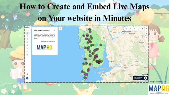
Why Use Live Maps in Your Content? In a world full of static images and walls of text, live maps offer something refreshing—interaction. Whether you’re writing about public parks, healthcare gaps, local events, or historical sites, embedding a map lets your readers explore the data directly, rather than just reading about it. It’s not just cool—it’s powerful. Imagine someone being able to click, zoom, and view real-time spatial info without ever leaving your blog.
The No-Code Way to Make It HappenYou don’t need to be a developer or GIS expert to add live maps to your stories. Tools like MAPOG make it easy to create custom maps without writing a single line of code. The process is simple: choose your area, add layers like parks or services, use visual tools such as buffers or walking zones, and generate your map. Once you’re happy with it, just hit share, copy the embed code, and paste it into your Tumblr post (or website, Notion, newsletter—you name it). That’s it!

Real-World Example: Park Accessibility Let’s say you're highlighting how many people have access to green spaces in your city. You can show administrative boundaries, pinpoint park locations, and even add a “10-minute walk” zone around each park—all visually. Anyone reading your post can instantly see what areas are underserved, just by looking at the map.
Who Is This For?
Bloggers telling local stories
Students working on research
Activists highlighting community gaps
Creators adding context to personal essays
Live maps turn your thoughts into something viewers can interact with. They help your audience see what you're saying literally.

Final Thoughts Adding an interactive map to your post isn’t just about aesthetics. It’s about giving your audience an experience—something they can explore. Thanks to platforms like MAPOG, you can do this in minutes, even without a technical background.
0 notes
Text
Top 5 Ways DJI Drones Are Used in Agriculture and Surveying
In today’s fast-paced world, the agricultural and surveying industries are rapidly evolving with the help of drone technology. DJI, the world’s leading drone manufacturer, has revolutionized how farmers and surveyors operate. With innovative drone models and high-precision cameras, DJI drones are transforming traditional methods into efficient, data-driven processes. In this blog, we will explore the Top 5 Ways DJI Drones are Used in Agriculture and Surveying, with a special focus on how DJI Camera Bangladesh is helping professionals unlock the full potential of this technology.

1. Precision Agriculture with Multispectral Imaging
DJI drones, like the DJI Phantom 4 Multispectral, provide farmers with real-time insights into crop health. These drones use advanced multispectral cameras to detect plant stress, identify disease, and monitor crop growth.
With the help of DJI Camera Bangladesh, farmers across the region are now accessing cutting-edge imaging solutions to make informed decisions, reduce chemical usage, and boost yield.
2. Efficient Land Surveying and Mapping
Surveyors are replacing traditional land surveying tools with drones like the DJI Matrice 300 RTK paired with L1 or P1 payloads. These high-end drones create accurate 2D and 3D maps using photogrammetry and LiDAR technology.
In Bangladesh, DJI Camera Bangladesh provides tailored drone solutions for engineers and GIS professionals to complete topographic surveys, construction planning, and infrastructure mapping faster and more accurately than ever.
3. Crop Spraying with Agras Drones
The DJI Agras series, including Agras T20 and T30, are revolutionizing pesticide and fertilizer spraying. These drones cover large areas with precision, minimizing waste and maximizing efficiency.
Through DJI Camera Bangladesh, farmers are getting access to professional spraying drones, customized training, and support—making smart farming more accessible and profitable.
4. Soil and Field Analysis
Before planting, DJI drones can perform soil analysis to determine field conditions, moisture levels, and soil composition. This data helps in planning seed distribution and irrigation strategies.
Agricultural experts working with DJI Camera Bangladesh utilize this technology to offer field analysis services that reduce guesswork and optimize farming results.
5. Monitoring and Inspection
For large agricultural lands and infrastructure projects, regular monitoring is critical. DJI drones provide real-time aerial footage and time-lapse data to monitor crop progress or inspect survey sites for any irregularities or damages.
DJI Camera Bangladesh supplies drones like the DJI Mavic 3 Enterprise, which are ideal for long-range observation and thermal inspections, helping both farmers and engineers maintain project timelines and ensure safety.
Conclusion
DJI drones are reshaping agriculture and surveying across the globe, and DJI Camera Bangladesh is playing a key role in this transformation. Whether it’s for precision farming, crop spraying, or land mapping, DJI’s advanced drone technology offers efficiency, accuracy, and productivity like never before.
If you’re a farmer, surveyor, or business owner in Bangladesh looking to leverage drone technology, DJI Camera Bangladesh has the expertise and products to guide your journey.
1 note
·
View note
Text
Why Drone Mapping Is Changing the Way We Do Drone Survey
In the world of modern surveying, drone mapping is leading a major shift. No longer do teams rely solely on ground-based tools or slow, manual data collection. Instead, industries ranging from construction to environmental science are turning to drone-based solutions for faster, more accurate insights.

At LiDAR Solutions, we harness the power of drone mapping to deliver comprehensive site data in record time. Our drone systems capture high-resolution aerial images and convert them into 2D maps or 3D models with precise geospatial information. These outputs help project managers, engineers, and decision-makers make informed choices based on real-world visuals and data.
When paired with lidar surveying, the technology becomes even more powerful. LiDAR (Light Detection and Ranging) uses laser pulses to measure distances and capture detailed surface data—even through dense vegetation or in low-light conditions. This makes it ideal for topographic studies, infrastructure planning, and mining exploration.
What sets LiDAR-based drone survey solutions apart is their ability to combine speed with accuracy. Instead of taking weeks to gather and process site data, we can deliver detailed models within days. This efficiency saves businesses time, reduces labour costs, and eliminates many of the hazards associated with manual surveys.
Using a drone survey also limits disruption. We can scan hard-to-reach or hazardous areas without stepping foot on unstable ground. Whether you’re planning a new development or monitoring environmental changes over time, our approach offers unmatched safety and reliability.
LiDAR Solutions brings industry-grade drone systems and experienced pilots to every project. We customise each survey to suit your specific requirements and deliver your data in ready-to-use formats. From contour maps to elevation models, our outputs integrate seamlessly with CAD and GIS software.
As regulatory bodies demand greater transparency and accuracy in planning documents, investing in reliable survey methods has never been more important. Businesses that adopt lidar surveying and drone-based technologies are staying ahead of the curve.
In short, the evolution of drone survey methods is reshaping the landscape of surveying and mapping in Australia. Whether you manage a major infrastructure project or need precise data for environmental compliance, our team is here to help.
Want to learn how our drone mapping services can elevate your next project? Contact LiDAR Solutions today for a no-obligation consultation.
Source
0 notes
Text
Top Color Sorting Machinery Manufacturers Delivering Innovation & Accuracy
In the highly competitive food processing and manufacturing sectors, quality control plays a pivotal role in ensuring that your products meet market standards and consumer expectations. One of the most effective ways to maintain superior quality is by using advanced color sorting machines that detect and remove defective or unwanted materials based on color differences.
But with so many options in the market, how do you select the best color sorting machinery manufacturers? Making an informed choice is critical because the right partner can boost your productivity, reduce waste, and enhance the overall quality of your output. Here are some key factors to consider when evaluating manufacturers of color sorter machines.

1. Industry Experience and Reputation
A manufacturer with extensive experience in producing color sorter systems usually understands the nuances of different materials and sorting requirements. Trusted color sorting machinery manufacturers have a proven track record of delivering machines that perform consistently under various operational conditions. Longevity in the business also indicates reliability and customer satisfaction.
Research companies that have successfully supplied automated color sorting machines to businesses in your industry—whether it’s rice milling, nut processing, pulses, plastics, or others. A manufacturer well-versed in your specific sector is better equipped to provide tailored solutions.
2. Advanced Technology and Innovation
The effectiveness of color sorter machines hinges on the sophistication of their technology. Look for manufacturers who incorporate the latest advancements such as:
High-resolution cameras and sensors for precise color detection
Multi-spectral imaging for sorting based on subtle color variations
Automated ejector systems that minimize product damage and maximize sorting accuracy
Top-tier color sorting machinery manufacturers constantly invest in research and development to ensure their products remain at the cutting edge. This commitment results in machines that can handle higher throughput with better accuracy, reducing material wastage and improving overall efficiency.
3. Customization and Flexibility
Every production line has its unique requirements. Whether it’s capacity, material type, or space constraints, your sorting machine needs to fit seamlessly into your process. The best automated color sorting machine suppliers offer a range of customization options, including:
Adjustable chute widths and hopper sizes
Programmable sorting parameters based on material properties
Integration capabilities with existing processing lines
This flexibility ensures you get a machine that not only performs well today but can adapt as your business grows or changes.
4. After-Sales Service and Technical Support
Purchasing a color sorter machine is a significant investment, and excellent after-sales support is essential for protecting that investment. Reliable manufacturers provide:
Comprehensive training for your operators
Easy access to spare parts
Timely troubleshooting and maintenance support
Remote diagnostics and software updates
A strong service network minimizes downtime and keeps your production line running smoothly. Companies like GI Agro Technologies are known for their dedicated customer service and quick response times, which helps clients maintain optimal operation of their color sorting machines.
5. Compliance, Quality Certifications, and Safety
It’s important to ensure that your color sorting machines meet international safety and quality standards. Certifications like ISO, CE, or others relevant to your region or industry indicate that the machines have passed rigorous testing for durability, safety, and performance.
Choosing manufacturers who adhere to these standards gives you peace of mind and can also ease compliance when exporting products internationally.
6. Affordability and Value for Money
While cost is an important consideration, don’t compromise on quality for a cheaper price. The goal is to find a balance between affordability and performance. Often, investing in a higher-quality color sorter reduces operational costs in the long term due to less material wastage, fewer breakdowns, and improved throughput.
Look for transparent pricing and warranty options. Reputable manufacturers clearly outline the color sorter machines’ specifications and costs, so you know exactly what you’re paying for.
7. Customer Testimonials and Case Studies
Before finalizing your decision, it’s wise to review feedback from other users of the color sorting machines you’re considering. Testimonials, case studies, and user reviews provide valuable insights into real-world performance, reliability, and support quality.
Manufacturers with positive client experiences across multiple industries tend to be more trustworthy and responsive to customer needs.
Conclusion
Selecting the right color sorting machinery manufacturers is crucial to optimizing your product quality and operational efficiency. By focusing on experience, technology, customization, support, compliance, and cost-effectiveness, you can make an informed decision that benefits your business in the long run.
For those seeking dependable automated color sorting machines backed by excellent service, GI Agro Technologies stands out as a trusted name in the industry. With a strong commitment to innovation and customer satisfaction, they deliver solutions that help businesses excel in quality sorting.
#colorsorter#colorsortermachines#colorsortingmachines#automatedcolorsortingmachinesupplier#colorsortingmachinerymanufacturers
0 notes
Text
High-Precision Mapping |Our Drone & Aerial Surveying Services
In today’s fast-paced and technology-driven world, traditional surveying methods are rapidly being replaced by advanced drone and aerial surveying solutions. Whether it’s construction planning, land development, mining operations, or agricultural monitoring, drone technology is revolutionizing the way we map, measure, and manage large-scale projects.
If you're looking for top drone and aerial surveying services in India, you're in the right place. Our expert drone service providers deliver accurate, efficient, and cost-effective mapping solutions tailored to meet the diverse needs of industries across the country.
Why Choose Drone Surveying & Mapping Services?
Drone-based surveying is not just a trend—it’s a powerful tool that offers several advantages over conventional methods:
High-Accuracy Results: Capture detailed images and data with centimeter-level accuracy using GPS-enabled drones and RTK technology.
Faster Data Collection: Complete surveys that once took weeks in just hours with aerial drones.
Reduced Manpower & Cost: Cut down on labor costs and time with automated drone flights.
Safety & Accessibility: Survey remote, hazardous, or hard-to-reach areas without risking lives.
Versatile Applications: Suitable for multiple industries—construction, mining, agriculture, oil and gas, urban planning, and more.
Our Drone Surveying Services Include:
Topographic & Contour Mapping We create precise topographic maps and contour lines for land development, construction, and urban planning projects.
Orthomosaic Mapping Generate georeferenced high-resolution maps stitched from drone-captured images, ideal for planning and analysis.
Digital Elevation Models (DEM) & Digital Surface Models (DSM) Get elevation data critical for hydrological modeling, flood risk analysis, and infrastructure design.
3D Modeling & Photogrammetry Create realistic 3D models of terrain, structures, and infrastructure with detailed visual representations.
Land Surveying & Volume Estimations Accurate volume calculations for stockpiles, cut/fill operations, and earthwork planning in mining and construction.
Asset Inspection & Monitoring Perform aerial inspections for power lines, pipelines, solar farms, wind turbines, and industrial assets without shutdowns.
Industries We Serve
We provide drone surveying and mapping services for:
Construction and Real Estate
Agriculture and Forestry
Mining and Quarrying
Oil and Gas
Infrastructure Development
Environmental Monitoring
Urban Planning and GIS Projects
Pan-India Coverage with Professional Support
Our drone service network spans across Delhi, Mumbai, Bangalore, Hyderabad, Chennai, Pune, Ahmedabad, and other major cities, ensuring timely project delivery and complete regulatory compliance with DGCA (Directorate General of Civil Aviation) guidelines.
Our licensed drone pilots and GIS specialists are trained professionals equipped with state-of-the-art drones and software to deliver exceptional results. From pre-project planning to post-processing and analysis, we offer end-to-end drone solutions that are reliable, scalable, and designed for success.
Contact Us Today Ready to take your surveying and mapping projects to new heights? Contact us now for a free consultation and discover how drone technology can optimize your operations and decision-making process.
0 notes
Text
Turning City Plans into Immersive 3D Vector Maps for Architecture Firms

3D Vector Maps for Architecture Firms
City planning has always been a critical process in shaping the urban experience. Whether it’s designing efficient transportation systems, allocating green spaces, or planning high-rise complexes, architecture firms rely heavily on visual tools to communicate ideas and envision development. Today, one tool stands out for its precision and immersive quality 3D Vector Maps.
By turning traditional 2D city plans into detailed 3D Map Illustration, architecture firms can visualize space, scale, and infrastructure with unmatched clarity. Let’s explore how immersive 3D vector maps are revolutionizing Architecture Illustration and what benefits they offer in modern urban planning.
What Are 3D Vector Maps?
3D vector maps are high-resolution digital representations of geographic and structural data, built using vector graphics rather than raster images. Unlike pixel-based maps, vector maps are scalable, editable, and interactive, making them perfect for dynamic architectural and urban projects.
When combined with 3D map illustration techniques, these maps evolve into layered, immersive models that allow stakeholders to zoom in, rotate, and explore city layouts in real-time. The result? More accurate planning, better client presentations, and fewer errors in execution.
From 2D City Plans to 3D Map Illustrations
Traditional city plans are often presented in 2D layouts—flat representations that show zoning, roadways, infrastructure, and plot divisions. That’s where 3D Map Illustration steps in.
Visualize elevations and topography
Place buildings and landmarks in spatial context
Simulate sun paths and shadows
Overlay zoning codes, utilities, and traffic systems
The transition is not merely aesthetic—it’s practical. 3D vector maps help architecture firms move beyond abstract drawings and into the realm of realistic, data-driven design.
Benefits for Architecture Firms
1. Enhanced Architecture Illustration
Instead of hand-drawn sketches or static renders, firms can offer clients an immersive tour through their proposed designs.
Features like interactive flyovers, real-time rendering, and zoomable details bring life to static plans. Whether for urban redevelopment or a new skyscraper, 3D map illustrations improve comprehension and engagement.
2. Improved Client Communication
Clients who aren’t trained in reading technical drawings often struggle to understand 2D plans. 3D Map Illustration translate those complex designs into accessible visuals. Architecture firms can now walk clients through every street, park, and tower in a proposed development using virtual maps.
This interactive communication eliminates ambiguity and builds trust, accelerating decision-making and approvals.
3. Faster Design Iterations
Need to move a residential block? Add a highway? Change the zoning layout? With 3D Vector Maps, edits can be made quickly without redrawing from scratch.
This saves time in the design phase and encourages more experimentation—ultimately leading to better urban solutions.
4. Integration with Smart City Technologies
Modern cities are embracing data-driven planning, and 3D Vector Maps serve as the foundation for smart city development. These maps can integrate with GIS (Geographic Information Systems), real-time traffic data, environmental sensors, and IoT devices to offer predictive insights.
Architecture firms that adopt 3D map illustration workflows position themselves at the forefront of smart city initiatives.
Key Use Cases
Urban Redevelopment
When city planners aim to revitalize an old district, 3D Map Illustration provide a clear before-and-after view. Historical data can be layered with new designs, showing how existing infrastructure adapts to modern needs.
Master Planning
Large-scale projects like university campuses, industrial zones, or sports complexes benefit from 3D Vector Maps by simulating how people, vehicles, and services will interact with the environment.
Infrastructure Design
Bridges, tunnels, and highways require detailed spatial planning. Vector-based 3D maps allow architects and engineers to understand gradients, elevation changes, and traffic flow in a visual context.
Environmental Impact Assessment
Mapping out water bodies, green spaces, and elevation levels helps firms predict the environmental impact of development. 3D map illustration tools can model drainage systems, erosion patterns, and sunlight distribution to guide sustainable designs.
Tools and Technologies Behind 3D Vector Mapping
The creation of 3D Vector Maps typically involves several software tools and data sources, such as:
GIS Data: Geographic Information Systems provide the base data, including terrain, land use, and infrastructure.
CAD Software: Tools like AutoCAD or Civil 3D help convert technical drawings into scalable 3D geometry.
3D Modeling Platforms: Software like SketchUp, Rhino, or Blender are used to build detailed models.
Vector Graphics Engines: Applications like Adobe Illustrator or Figma (with 3D plugins) allow designers to craft vector-based illustrations.
Rendering Engines: For lifelike visualization, rendering tools like Lumion or Twinmotion bring the 3D maps to life.
The seamless integration of these tools ensures architecture firms can deliver precise, visually engaging, and editable 3D visuals.
How to Get Started with 3D Map Illustration
If your architecture firm is ready to embrace 3D Map Illustration, here’s a step-by-step approach to get started:
Step 1: Collect Accurate Base Data
Precision at this stage ensures your vector map is accurate.
Step 2: Choose the Right Software Stack
Depending on your team’s expertise, choose tools that offer compatibility with 3D modeling and vector-based editing. Look for platforms that support collaborative workflows.
Step 3: Define the Layers
Break the map into logical layers—terrain, roads, utilities, buildings, vegetation, and more. This modular structure makes editing and analysis easier.
Step 4: Model in 3D
Using 3D software, convert your base layers into dimensional models. Apply real-world scales, textures, and lighting to create an immersive experience.
Step 5: Refine and Illustrate
Now comes the creative part—refining your 3D vector map with color coding, annotations, icons, and symbols.
Step 6: Render and Present
Export your map into interactive formats for web, video walkthroughs, or VR presentations. Make sure your output is optimized for both client review and internal decision-making.
The Future 3D Vector Maps
The future of Architecture Illustration lies in immersive, interactive experiences. As augmented reality (AR), virtual reality (VR), and real-time rendering become mainstream, 3D map illustrations will evolve from tools of presentation to tools of simulation.
Imagine city planners using VR goggles to explore a new district before laying a brick, or stakeholders manipulating buildings in real-time to optimize space usage. With 3D Vector Maps, that future is already unfolding.
Conclusion
In the competitive world of urban design and architecture, standing out means embracing innovation. 3D Map Illustration and 3D vector maps are no longer optional—they are essential tools that drive clarity, precision, and creativity.
By transforming 2D city plans into immersive 3D experiences, architecture firms can communicate ideas more effectively, design smarter, and contribute to the creation of more livable, sustainable cities. Whether you're designing a neighborhood or reimagining a skyline, it's time to bring your maps to life—one vector at a time.
0 notes
Text
Why Is GIS Surveying in High Demand in the UAE? Unlocking Accurate Data for Smarter Decisions
In the middle of the Arabian Peninsula, the United Arab Emirates shows off what people can accomplish through their ideas and the use of new technology. Among all the digital changes happening in this country, GIS surveys and data processing have become important tools for building roads and homes, planning cities, and taking care of the environment. Embracing GIS shows that the UAE values using data for decisions, helping the country progress sustainably in a world where things are getting more intricate.

The Evolution of GIS in the UAE started as a way to track and map important data for cities, and now it is used for almost all types of activities and services in the country.
The technology started as simple ways to map areas and has grown into tools that examine how different areas relate to each other across the country. The government of the UAE saw from the start that effective handling of spatial data would be key for achieving its big development plans. Today, GIS is used in many parts of life in the UAE, like helping people build things, plan roads, find doctors, and attract tourists.
Applications Transforming the Nation
The footprint of GIS survey and data processing covers different fields in the UAE. They make it possible for those working in urban planning to visualize, assess, and improve city designs before starting construction. GIS technology was used to design the Palm Jumeirah island in Dubai to provide strong structures and ensure that it does not harm the environment.
Scientists in the field use GIS to look out for changes in the shape of dunes and to locate places that might turn into deserts. By having this data, officials can work more effectively to manage and protect water resources where there is a long-standing problem with not having enough water.
Advanced-Data Collection Methods
The accuracy of GIS applications is mostly determined by how good the data are that people gather. Data collection in the UAE uses important methods such as LiDAR, imaging via drones, and imagery from satellites to ensure the highest level of accuracy. With mobile GIS, teams can catch data live and prevent mistakes made by humans.
showing how committed they are to data, the city’s Smart Geospatial Contact Center uses AI to check and correct geographical information used in different systems. The focus on data accuracy has made the UAE a leader in geospatial intelligence in the region.
Digital Transformation and Integration
It is not just the use of GIS that makes the UAE unique, but also how they connect GIS with different digital tools. By using GIS data, the country’s efforts to become a smart city create well-connected urban areas where different complimentary systems and services are together.
The Roads and Transport Authority in Dubai uses GIS to improve traffic management, cut down on congestion, and set up future transportation systems. As another example, telecom companies use precision mapping so that underground operations during maintenance and construction are less likely to disrupt visitors or everyday usage.

Overcoming Challenges Through Innovation
Certain problems arise when GIS surveys and data processing are used in the UAE. Difficult desert conditions influence the tasks conducted by oilfield workers and the performance of equipment. Fast growth in cities means that spatial databases must be updated often to remain precise.
As a result, people have devised new ways to tackle these issues. Companies in the UAE have both designed heat-resistant tools and developed new techniques for surveying deserts. Initiatives from the government, including the UAE Spatial Data Infrastructure, have helped to ensure standards for data sharing and compatibility, making the whole national spatial data system more unified.
Building Local Expertise
Understanding that the impact of technology depends on learning, the UAE has focused on developing GIS experts within the country. Colleges and universities offer courses in geospatial sciences, and there are professional certification courses available for already-employed individuals. As a result, the knowledge is shared and helps build lasting resources within the Emirates.
The Road Ahead
When we think about the future, GIS survey and data processing in the UAE will include emerging technologies such as artificial intelligence and blockchain to make both data analysis and security better. They will help the country achieve vital objectives, like ensuring enough food and adapting to climate change.
By embracing GIS in the UAE, the country has demonstrated that using spatial intelligence can help strengthen, organize, and sustain a society. With the help of GIS, Emirati agencies can now study and survey the regions of Abu Dhabi and Dubai, while mapping how the economy moves toward knowledge-work.
Accurate Survey UAE provides precise land, building, and construction surveys using advanced technology, ensuring reliable results for projects across the UAE. If you would like to learn more about GIS survey and data processing, you can visit the page.
0 notes
Text
The Rise of Intelligent Maps: GIS AI Services in Malaysia
The Rise of Intelligent Maps: GIS AI Services in Malaysia
Geographic Information Systems (GIS) have long been indispensable tools for mapping, analysis, and decision-making across various sectors in Malaysia. From urban planning in bustling Kuala Lumpur to managing the rich biodiversity of Borneo, GIS provides critical spatial insights. However, a new era is dawning, one where the power of Artificial Intelligence (AI) is being seamlessly integrated with GIS, promising to unlock unprecedented levels of efficiency, accuracy, and predictive capabilities. This fusion is giving rise to a dynamic landscape of GIS AI services in Malaysia, poised to revolutionize how we understand and interact with our world.
What is GIS AI?
At its core, GIS AI involves leveraging AI algorithms and techniques within a GIS framework. This integration goes beyond simply visualizing spatial data; it enables systems to learn from patterns, automate complex analyses, and even predict future spatial events. Think of it as adding a layer of intelligent interpretation and automation to the already powerful capabilities of GIS.
Several key AI technologies are driving this evolution in Malaysia:
Machine Learning (ML): Algorithms that allow GIS to learn from data without explicit programming. This includes techniques like classification, clustering, and regression, enabling tasks such as land use classification from satellite imagery or predicting areas prone to landslides.
Deep Learning: A subset of ML that utilizes artificial neural networks with multiple layers to analyze complex data like high-resolution imagery and LiDAR data, facilitating tasks like object detection (e.g., identifying buildings or vehicles) and semantic segmentation (e.g., delineating different types of vegetation).
Computer Vision: Enables GIS to "see" and interpret visual information from images and videos, crucial for applications like automated feature extraction and change detection.
Natural Language Processing (NLP): Allows users to interact with GIS using natural language queries, making spatial analysis more accessible to non-experts.
The Malaysian Landscape: Early Adoption and Potential
While still in its nascent stages, the adoption of GIS AI services in Malaysia is gaining momentum. Several local players and international companies operating in the region are beginning to offer or explore AI-enhanced GIS solutions.
Companies like IDERIA Sdn Bhd are actively promoting their "AI-GIS" software, emphasizing its capabilities in automating editing, analysis, and cartography. They also highlight its scalability and web-enabled features, making geospatial content accessible across organizations.
GIS Innovation Sdn Bhd, a Malaysian-based company with extensive experience in GIS solutions, partners with Safe Software's FME, a no-code platform for integrating and transforming spatial data, which can be a crucial step in preparing data for AI analysis.
Furthermore, established GIS technology providers like Esri Malaysia and RedPlanet Grp (partnering with SuperMap) are highlighting the integration of AI into their platforms. SuperMap, for instance, emphasizes "AI GIS" as one of its core technology systems, focusing on GeoAI (spatial analysis algorithms integrated with AI) and AI for GIS (enhancing GIS software functionality with AI).
Benefits of GIS AI: A Game Changer for Malaysia
The integration of AI into GIS offers a multitude of benefits for various sectors in Malaysia:
Enhanced Decision-Making: AI can extract more profound insights from complex spatial datasets, providing actionable intelligence for data-driven decisions in areas like urban planning, resource management, and disaster response.
Increased Efficiency and Automation: Repetitive and time-consuming GIS tasks, such as data cleaning, feature extraction, and change detection, can be automated using AI, freeing up human analysts for more strategic work.
Improved Accuracy and Precision: AI algorithms can analyze vast amounts of geospatial data with greater accuracy and precision than traditional manual methods, leading to more reliable results.
Predictive Analytics: GIS AI can identify patterns and trends in spatial-temporal data to forecast future events, such as traffic congestion, disease outbreaks, or environmental changes, allowing for proactive planning and mitigation.
Real-Time Insights: By processing real-time data streams from sensors, IoT devices, and other sources, GIS AI can provide up-to-the-minute spatial intelligence for applications like smart city management and emergency response.
Optimized Resource Allocation: AI-powered GIS can analyze spatial demand and distribution to optimize the allocation of resources, whether it's for logistics, public services, or environmental conservation efforts.
Applications Across Malaysian Industries
The potential applications of GIS AI services in Malaysia are vast and span across numerous industries:
Urban Planning and Smart Cities: AI can analyze urban sprawl, traffic patterns, and population density to optimize city planning, improve infrastructure development, and enhance the efficiency of public services. Imagine AI predicting traffic bottlenecks in Kuala Lumpur and suggesting dynamic traffic light adjustments.
Agriculture and Natural Resource Management: AI can analyze satellite imagery to monitor crop health, predict yields, detect deforestation, and manage wildlife habitats more effectively, contributing to sustainable agriculture and environmental conservation in Malaysia's diverse ecosystems.
Disaster Management: GIS AI can be crucial in predicting and responding to natural disasters like floods and landslides, which are significant concerns in Malaysia. AI can analyze historical data, weather patterns, and terrain information to identify high-risk areas and optimize evacuation plans.
Telecommunications: AI-powered GIS can assist in network planning and optimization for telecommunication companies, ensuring efficient coverage and identifying areas for infrastructure upgrades, particularly important for expanding 5G connectivity across Malaysia.
Logistics and Transportation: AI can optimize delivery routes, manage logistics networks, and improve transportation efficiency, reducing costs and travel times for businesses operating throughout Malaysia.
Environmental Monitoring: AI can analyze remote sensing data to monitor air and water quality, track pollution sources, and assess the impact of climate change on Malaysia's environment.
Land Management: Integrating AI and GIS can improve the efficiency and precision of land allocation systems, aiding in decision-making and promoting sustainable land use practices.
Challenges and the Path Forward
Despite the immense potential, the widespread adoption of GIS AI services in Malaysia faces certain challenges:
Data Availability and Quality: Training effective AI models requires large volumes of high-quality, spatially referenced data, which may not always be readily available or standardized across different regions and sectors in Malaysia.
Technical Expertise: Implementing and utilizing GIS AI solutions requires skilled professionals with expertise in both GIS and AI, and there might be a shortage of such talent in the Malaysian market.
Computational Resources: Processing large geospatial datasets and training complex AI models can be computationally intensive, requiring access to robust infrastructure.
Integration with Existing Systems: Integrating new GIS AI solutions with existing legacy GIS systems and other enterprise IT infrastructure can be complex and costly.
Privacy and Ethical Considerations: Handling location data raises significant privacy concerns that need to be addressed through appropriate regulations and ethical guidelines.
To overcome these challenges and fully leverage the power of GIS AI in Malaysia, several steps are crucial:
Investing in Data Infrastructure: Efforts to improve the collection, standardization, and accessibility of high-quality geospatial data are essential.
Developing Local Talent: Educational institutions and industry training programs should focus on building expertise in both GIS and AI.
Promoting Collaboration: Collaboration between government agencies, research institutions, and the private sector can foster innovation and knowledge sharing in the field of GIS AI.
Establishing Clear Guidelines: Developing clear policies and ethical frameworks for the collection, use, and sharing of geospatial data is crucial to address privacy concerns.
The Future is Intelligent: GIS AI in Malaysia
The integration of AI into GIS represents a significant leap forward in our ability to understand and interact with the spatial world in Malaysia. As AI technologies continue to advance and become more accessible, we can expect to see a proliferation of innovative GIS AI services that address a wide range of challenges and opportunities across the nation. From smarter cities and sustainable resource management to more effective disaster response and optimized business operations, the future of GIS in Malaysia is undoubtedly intelligent, promising a more informed, efficient, and resilient nation. The journey has just begun, and the potential is truly limitless.
0 notes
Text
Why Do You Need GI Mark Infringement Services to Guard Your Brand?

The current times of intense market competition and difficult economics have made it mandatory for a brand to exist. For the producers and businesses that have been allocated GIs, brand protection is of paramount concern. Wear and tear of such protection will not only be risky for the image of the brand but also it will be the reason behind underperformance and a source of confusion among the consumers. As a result, the services dealing with GI mark infringement have been developed. The core of the new resolutions is the preservation of the products' cultural heritage and the consequent sustaining of the quality of their promise to the customers, i.e., the trust of the consumers.
By various means, this publication unravels the nature and scope of these services, and it lists their positive aspects and supports Geographical Mark Investigation Services as the crusaders who are in charge of protecting the brands' culture and tradition against any form of infringement as indispensable. Such instances reiterate the importance of putting an emphasis on the brands' local roots to provoke empathy from the consumers through the stories narrating the making of the product.
What Are GI Marks and Why Are They Important?
A Geographical Indication (GI) Mark is a sign used to indicate products that have their place of origin in a specific area, and also have certain qualities, characteristics, or reputation that are directly associated with that place. The most widely-known examples are Darjeeling Tea, Mysore Silk, and Basmati Rice.
The products which come with a GI label are considered genuine and their value is coming from many things including geography, traditional culture, and handmade production. However, when people abuse these marks, the harm is not just limited to the economy — cultural heritage, as well as the trust of the consumers, are at risk. According to the World Intellectual Property Organization (WIPO), the annual amount of global trade losses due to fake GI products is in the billions.
It is in this context that investigations into GI mark infringement are carried out as a solution to enforce and protect the business.
The Role of GI Mark Infringement Services
GI mark infringement services are there for detecting, confirming, and dealing with the false application of GI tags in physical and online markets. In the majority of cases, such services are offered by law firms, agencies for intellectual property protection, and authorized investigators.
Many of the GI mark infringement services are to make sure of all the following regarding the products branded with a GI label:
Are produced in the registered geographical region
Follow the approved method of production
Meet the quality standards outlined in the GI registry
As a result of the implementation of Geographical Mark Investigation Services, replica commodities are detected, pieces of evidence are assembled, and legal procedures are kicked off. These steps are a means by which the genuine producers are safeguarded, and consumer confidence is kept.
How Investigations are Done
The approach taken by GI mark protection services appears to be very well described and all aspects are in good order, like they should be. Usually, this process is composed of several stages and requires engagement with societal representatives and the authorities.
1. Market Surveillance
Ongoing surveillance which is done in the physical markets, at exhibitions, and from web stores is undertaken. At this stage, the products which are suspected to be deceptive by the GI labels are identified. These labels are investigated in order to find out whether they are real or fake, and whether they have been correctly applied to the products as well as if they are GI conformant.
For example, the exclusively well-coordinated activities of the GI product investigation services led to the detection of fake "Banarasi Sarees" being marketed in the metropolitan cities and on the internet at a much lower price than the originals.
2. Evidence Collection and Documentation
When the product in question has, on the basis of some determinations, been designated as doubtful, then the agents are left to harvest some evidence of the product such as:
Samples of the product
Images of packaging and labeling
Purchase receipts
Seller interviews
Then, after the data collection, the information undergoes a review in order to assure the product's conformance with the Geographical Indication Act and regional GI guidelines.
3. Legal Collaboration and Enforcement
Theft and related offences and should there be any, consequent actions can be taken. Legal [informal concept] may be given to the infringer through the platform, and should it be necessary, a criminal lawsuit is filed.
It has also resulted in the culprits being given fines and their commercial activities being curtailment through the cancellation of their trading licenses.
The Benefits of GI Mark Infringement Services
The provision of professional GI tag infringement services can be a major game-changer for producers and the business sector. Some of the benefits that they provide are:
1. Brand Protection and Market Trust
One of the things that make the removal of imitation products from the market a good thing is that the real product's image remains intact. Brands that are very active in the issue consumers with trust due to the authenticity that the brands ensure.
2. Economic Safeguarding for Producers
Producers who offer genuine articles most often rely on traditional methods and local customs. Also, the services guarantee that these producers are not overrun by imitators therefore, they are able to perform very well.
3. Adherence to Intellectual Property Laws
The producers can understand compliance with GI mark to keep their products on the legal side. Through this monitoring, they will be able to avoid disputes, penalties, or lawsuits.
4. Online Monitoring of Platforms
Most of the GI tag monitoring services have now become online brand protection platforms against counterfeiters on the e-commerce market. It is very important today to have such a monitoring service, because the internet has made the sale of counterfeit goods very easy. Through this channel, the brands are tracked and the offenders are reported upon.
Challenges Faced in Protecting GI Marks
Despite the presence of Geographical Mark Investigation Services, there are still a few challenges in the fight against GI fraud:
Low consumer awareness about GI certification
Lack of standardized digital verification methods
Minimum or no sanctioning of offenders mostly in rural or informal markets
High cost of legal proceedings for small producers
Research by the Indian Institute of Foreign Trade (IIFT) revealed that hardly over 30% of consumers knew about GI tags or why they are important, which makes it even more difficult for the products to be traced and reported if fake.
In order to resolve these challenges, the collaboration of public institutions, provisional enterprises, and social groups should be aimed at.
A Human-Centric Approach to GI Protection
The overwhelming power of GI mark violation procedures is their being a real help to both manufacturers and customers. Support from GIs certification investigation services helps the keepers of traditional arts and crafts, food growers, and handicraft persons maintain their livelihood and receive proper recognition.
In the same manner, patrons gain the knowledge that legitimately they are spending their money on the products that are real, of good quality, and obtained in a legal way. A bond of trust is established among the stakeholders, which leads to a more respectful and sustainable trading environment.
Conclusion
The instant problem related to GI marks infringement is not only legal but also cultural and economic. Thus, the scare known as Geographical Mark Investigation Services is effectively preventing the brands connected with tradition and purity from being attacked every time.
Marketplaces mature and ways of trade multiply thus making the possibility of GI tag misuse even more significant. However, with meticulous surveillance work, investigation, and enforcement, the protection of GI-labeled products becomes a reality.
From the producers' side, also the artists, and buyers nothing is questioned: GI marks, should be the services to help them be sure that can be protected reiterate, yes? - and also consumers (via the right services) who agree.
#gi mark protection#gi mark infringement investigation#gi mark investigation#geographical indication mark enforcement services
0 notes
Text
Gastrointestinal Oncology – Specialized Cancer Care for Digestive Tract Malignancies
Gastrointestinal (GI) oncology focuses on the diagnosis and treatment of cancers affecting the digestive tract and related organs. At Dr. Nitin Singhal’s clinic, gastrointestinal oncology services are designed to manage both early-stage and advanced cancers involving the esophagus, stomach, small and large intestines, liver, pancreas, gallbladder, and rectum.
This subspecialty addresses a wide spectrum of conditions, including:
Esophageal and gastric cancer
Colorectal cancer (colon and rectum)
Pancreatic cancer
Liver and bile duct cancers (hepatocellular carcinoma, cholangiocarcinoma)
Neuroendocrine tumors of the GI tract
Treatment begins with a thorough diagnostic process, including imaging, endoscopy, biopsy, and tumor staging. Once a diagnosis is confirmed, patients are evaluated by a multidisciplinary team to determine the most appropriate treatment plan. This may involve surgery, chemotherapy, radiation therapy, targeted drugs, or a combination of approaches based on the tumor type and stage.
Surgical care for GI cancers includes minimally invasive and advanced techniques such as robotic surgery, laparoscopic resections, and cytoreductive surgery with HIPEC when indicated for peritoneal spread. The goal is to remove tumors effectively while preserving organ function and ensuring optimal recovery.
For advanced or inoperable cancers, systemic therapies such as chemotherapy and targeted agents are used to control disease progression and improve quality of life. In select cases, palliative care options are integrated early in the treatment pathway to manage symptoms and support overall well-being.
Dr. Nitin Singhal’s focus on gastrointestinal oncology reflects a commitment to comprehensive, patient-centered cancer care. Each treatment plan is customized to the individual’s condition, ensuring evidence-based decisions guided by clinical expertise and the latest advancements in GI cancer therapy.
0 notes
Text
Drone Land Surveying by Equinox Drones: Fast, Accurate, and Cost-Effective

Equinox Drones is transforming the landscape of land surveying through advanced drone technology. Traditional surveying methods are time-consuming, labor-intensive, and often limited by terrain or accessibility challenges. At Equinox, we offer drone land surveying solutions that are faster, safer, and more precise—making it the smart choice for developers, engineers, architects, and landowners.
Our professional drone surveying services combine cutting-edge UAV platforms with high-resolution cameras, GPS, RTK (Real-Time Kinematic) positioning systems, and photogrammetry software to capture detailed spatial data. This allows us to generate highly accurate topographic maps, digital elevation models (DEMs), orthomosaic images, and 3D models—delivering actionable insights in a fraction of the time of traditional ground-based methods.
What Sets Equinox Drone Land Surveying Apart?
1. Precision and Accuracy Our drones are equipped with RTK and PPK (Post-Processed Kinematic) GPS systems, enabling centimeter-level accuracy. This ensures the data collected is suitable for engineering-grade work, boundary mapping, and legal documentation.
2. Speed and Efficiency What normally takes a team of surveyors several days can be completed by Equinox Drones in just a few hours. We cover large and complex areas quickly, reducing project timelines and labor costs without compromising accuracy.
3. Safety and Accessibility Drones can easily access difficult, dangerous, or remote locations without putting people at risk. Whether it’s steep terrain, dense forests, or active construction zones, our UAVs navigate it all safely from above.
4. Comprehensive Data Outputs We deliver high-resolution orthomosaics, 2D maps, 3D terrain models, and CAD-ready outputs. These deliverables can be used for site planning, volume calculations, land development, infrastructure design, and environmental studies.
Applications of Drone Land Surveying
Site Planning & Development Developers and architects use our drone surveys to plan site layouts, identify grade differences, and assess drainage and access points with precision.
Construction & Engineering We support every stage of construction, from pre-construction analysis to ongoing progress monitoring and final site inspections. Our volumetric measurements are ideal for tracking cut/fill operations and material stockpiles.
Environmental & Agricultural Assessment Landowners and environmental consultants use our surveys to monitor erosion, vegetation coverage, watershed patterns, and soil conditions.
Mining and Resource Management Our drones assist in monitoring quarries, calculating stockpile volumes, and ensuring compliance with regulations through frequent and affordable surveying.
Why Choose Equinox for Land Surveying?
At Equinox Drones, we’re more than just drone pilots—we’re aerial data specialists. We work closely with engineers, surveyors, and GIS professionals to ensure the data we provide meets the exact specifications of your project. Every survey is conducted by a certified pilot using FAA-approved flight plans and backed by a thorough quality control process.
Whether you're surveying hundreds of acres for a new housing development or mapping a single parcel for land division, Equinox Drones delivers reliable, cost-effective results—faster than ever before.
Let us elevate your next land surveying project. Choose Equinox Drones and experience the future of aerial data collection.
0 notes
Text
AI & Self-Driving Cars: A $25.8B Industry by 2034 – The Future is Now!
AI in Autonomous Vehicle Sensors Market is accelerating towards a smarter, safer future, integrating AI-driven LiDAR, radar, and camera systems to enhance vehicle perception and decision-making. These cutting-edge sensors enable autonomous vehicles to navigate complex environments, ensuring efficiency and safety while reducing accidents and optimizing traffic flow. 🚦
To Request Sample Report : https://www.globalinsightservices.com/request-sample/?id=GIS33019 &utm_source=SnehaPatil&utm_medium=Article
🔍 Market Overview LiDAR leads the market, offering unmatched accuracy in environmental mapping and obstacle detection. Camera sensors follow closely, benefiting from advancements in AI-driven image processing. Radar sensors, while slightly behind, are gaining traction due to their reliability in adverse weather conditions.
🌎 Regional Insights
North America dominates, driven by massive investments and technological innovation in autonomous vehicle development.
Europe ranks second, benefiting from stringent safety regulations and a strong automotive industry.
Key players: The United States and Germany spearhead advancements, fostering strategic partnerships to enhance sensor accuracy and AI integration.
📊 Market Segmentation & Key Trends
Type: LiDAR, Radar, Ultrasonic, Camera, Infrared Sensors
Application: Passenger Vehicles, Commercial Vehicles, Ride-Sharing, Logistics
Technology: Machine Learning, Deep Learning, Computer Vision, Sensor Fusion
Functionality: Perception, Localization, Mapping, Decision-Making
Deployment: Cloud-Based, Edge-Based, Hybrid
🚀 Future Outlook The LiDAR segment dominates, while camera-based sensors hold 30% of the market, followed by radar sensors at 25%. Major players like Velodyne Lidar & Luminar Technologies are driving innovation, while regulatory frameworks in the US & EU shape safety standards. 🚘 Despite high production costs, increased R&D investments and AI integration will fuel growth, making autonomous driving a reality!
#autonomousvehicles #aiinsensors #lidartechnology #radarsensors #camerasensors #sensorfusion #driverlesscars #futureofmobility #smarttransportation #aiinmobility #deeptech #machinelearning #computervision #automotiveinnovation #robotaxis #selfdrivingcars #nextgentech #avtechnology #smartcities #connectedcars #automateddriving #aiintheautomotiveindustry #techforgood #vehicletechnology #innovationdriven #ridesharing #logisticsautomation #autonomousfleets #smartmobilitysolutions #evfuture #mobilitydisruption #automotivesensors #mappingtechnology #cloudcomputing #aiinlogistics #edgecomputing
Research Scope:
· Estimates and forecast the overall market size for the total market, across type, application, and region
· Detailed information and key takeaways on qualitative and quantitative trends, dynamics, business framework, competitive landscape, and company profiling
· Identify factors influencing market growth and challenges, opportunities, drivers, and restraints
· Identify factors that could limit company participation in identified international markets to help properly calibrate market share expectations and growth rates
· Trace and evaluate key development strategies like acquisitions, product launches, mergers, collaborations, business expansions, agreements, partnerships, and R&D activities
About Us:
Global Insight Services (GIS) is a leading multi-industry market research firm headquartered in Delaware, US. We are committed to providing our clients with highest quality data, analysis, and tools to meet all their market research needs. With GIS, you can be assured of the quality of the deliverables, robust & transparent research methodology, and superior service.
Contact Us:
Global Insight Services LLC 16192, Coastal Highway, Lewes DE 19958 E-mail: [email protected] Phone: +1–833–761–1700 Website: https://www.globalinsightservices.com/
0 notes