#LiDAR Scanning
Text
Lidar Shows Huge Network of Ancient Cities in the Amazon
Advanced imaging technology has unearthed massive networks of cities in areas of what is now thick Amazon rainforest. Using lidar (light detection and ranging), scientists have discovered large areas that show raised earthen platforms in neat rows. They are connected by extensive networks of roads.
Ranging from 3000-1500 years ago, the ancient cities show that this part of the world once had…

View On WordPress
#5000 years old#Amazon cities#ancient cities#ancient civilizations#lidar imaging#lidar jungle#Lidar scanning#Nijiamanch#Upano Valley
1 note
·
View note
Photo
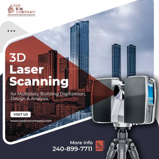
3D laser scanning is a method of collecting extremely fine and correct information about a construction area using laser rays. A laser beam assesses the structure’s numerous dimensions, including the length, width, and height of the construction elements, and also their connections to each other.
The point cloud image created by the 3D laser scanning precisely copies the scanned objects. Based on the make and type of the 3D scanner, it could be used up to a distance of many meters. The information obtained can subsequently be utilized to construct 2D CAD drawings or 3D Revit BIM models using Building Information Modeling (BIM) and Computer-Aided Drawing (CAD) tools.
#3D laser scanning#Laser Surveying#LiDAR Scanning#3d building scanning#2D CAD drawings#3D Revit BIM models
0 notes
Text
vimeo
3D Scan Showreel 2023 (Photogrammetry & Lidar Scanning)
0 notes
Text
Understanding LiDAR Technology in Scan to BIM
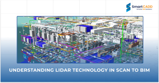
LiDAR (Light Detection and Ranging) technology has become an essential tool for Scan to BIM services due to the construction industry's demand for accurate and effective data collection.
LiDAR accurately depicts the built environment by measuring distances and constructing highly realistic three-dimensional (3D) reconstructions of existing structures using laser pulses.
The article will go into depth on LiDAR technology, its usage in Scan to BIM, and how it is transforming the way we approach building documentation and design.
What is LiDAR
Light detection and ranging, or LiDAR for short, is a remote sensing technique that measures distances to Earth using light in the form of a pulsed laser.
These light pulses provide exact, three-dimensional information on the Earth's structure and surface properties when paired with other data captured by the aerial system.
Here's a breakdown of how LiDAR works:
Laser Pulse Emission: Rapid laser pulses are emitted by LiDAR systems, and these pulses bounce off surfaces and objects in their path. The duration of time it takes for each pulse to return after reflecting off the surface is recorded by the system.
Distance Measurement: LiDAR determines the distance to each point it encounters by timing the return of light to the sensor. We call this procedure "time-of-flight measurement."
Point Cloud Creation: A "point cloud," or a collection of data points that represent the scanned region, is created using the distance information gathered from many laser pulses. X, Y, and Z are the three-dimensional coordinates for every point in the cloud.
Penetration Capabilities: One of LiDAR's specialties is its ability to see through obstacles such as dust, vegetation, and fog. This makes it very adaptable to various locations by enabling it to record data in a range of weather situations and coverages.
High Accuracy and Detail: LiDAR is renowned for its high level of accuracy and detail. It can capture fine details over large areas, providing a precise digital map of features that might be missed by other surveying methods.
Learn how 3D laser scanning improves project accuracy and saves money in construction. For more insights, read the full article here.
Applications of LiDAR in Scan to BIM
The combination of LiDAR technology with Scan to BIM methods opens up a wide variety of possibilities in the AEC sector. This formidable combination excels in the following important areas:
As-Built Documentation
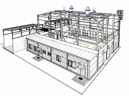
In Scan to BIM, one of the most important uses of LiDAR is the creation of very precise as-built documentation. LiDAR scans are utilized to precisely create BIM models by capturing existing structures, including their complex features.
This visual depiction of a structure's or infrastructure's current condition is very helpful for projects including facility management, refurbishment, and restoration. Architects, engineers, and facility managers may confidently plan their projects and make well-informed choices when they have access to an exact digital twin.
Clash Detection and Coordination
When determining any conflicts or interferences between new and existing structures, LiDAR data is essential. Early in the design process, conflicts between mechanical, electrical, and plumbing systems may be found by merging LiDAR scans with BIM models.
By being proactive, this method improves coordination amongst many professions and lowers the possibility of expensive onsite mistakes and delays. LiDAR reduces unforeseen problems during construction, which facilitates more efficient project management.
Topographical Surveys
Topographical surveys are a specialty of LiDAR, which provides accurate terrain data for infrastructure projects, urban planning, and landscape design. Engineers and designers may use LiDAR to record current ground characteristics, such as vegetation, elevations, and contours, to help them make well-informed choices. Grading, drainage design, and making sure that new projects blend in with the surroundings all depend on this data.
Historical Preservation and Renovation
A non-invasive technique for obtaining the minute details of old buildings and structures is LiDAR scanning. By using this technology, the heritage of these locations is preserved for future generations in the form of a digital archive.
LiDAR data helps to create a smooth transition between new designs and the distinctive features of the current building when it comes to renovation projects. By using this application, historical structures are guaranteed to be repaired appropriately and to retain their cultural relevance.
Find out how combining 3D scanning with BIM makes renovation projects more efficient. Learn more by reading here.
Quantity Take-offs and Cost Estimation
LiDAR data's comprehensive nature simplifies quantity take-offs and offers precise measurements for cost and material calculations.
LiDAR lowers the possibility of cost overruns and allows more effective budgeting by producing accurate as-built models. By improving the entire financial management of building projects, this tool helps decision-makers make more informed choices.
Benefits of LiDAR in Scan to BIM
The AEC sector benefits greatly from the incorporation of LiDAR into Scan to BIM operations. The following main advantages demonstrate the importance of this technology:
Accuracy and Precision: LiDAR's extremely detailed point clouds guarantee that the measurements used to create BIM models are accurate and precise. This precision lowers the possibility of mistakes, cuts down on expensive rework, and improves the general caliber of building projects.
Efficiency and Speed: Quick laser scanning enables speedier site evaluations, which shortens project schedules. Additionally, simpler processes and quicker project completion are facilitated by the effectiveness of LiDAR data processing and the capacity to produce BIM models rapidly.
Increased Safety: By minimizing the need for workers to enter dangerous regions, LiDAR scanning increases the safety of construction sites. Accident risk may be reduced by doing scans remotely. Furthermore, before personnel are deployed, LiDAR data may detect possible safety dangers like structural problems or invisible obstacles, allowing for improved safety procedures and on-site risk management.
Enhanced Coordination and Collaboration: LiDAR scans reduce conflicts between mechanical, electrical, and plumbing systems by facilitating early collision identification by giving a complete digital image of the current site.
Flexibility and Richness of Data: LiDAR produces extremely dense point clouds that provide a plethora of information that may be used to a variety of tasks beyond original planning. This extensive dataset enables comprehensive research, including building management, daylighting studies, and energy efficiency evaluations.
Wrapping UP
The construction sector has shifted significantly as a result of the integration of LiDAR with Scan to BIM procedures. This strong mix improves accuracy and creates a more efficient process, which results in accurate project executions.
LiDAR is here to stay and evolve with Scan to Bim Services whilst improving decision-making, and resource allocation, reducing mistakes, and ensuring smooth coordination of operations in the AEC Industry.
0 notes
Text
Maybe instead of filling the void I can build a type of scaffolding across the surface and work my way down, to make its depths accessible, then go from there 🤔🏗️📐
0 notes
Text
What is LIDAR: Illuminating Remote Sensing for Accurate Mapping and Other Applications?
Understanding what is LiDAR, or light identification and ranging, is an acronym. It's a kind of remote sensing where laser light is used to map the surroundings precisely in three dimensions and estimate distances. Laser beams are directed at a target using this approach, and the time it takes each beam to return to the sensor is then measured. A LiDAR system uses an estimation of the distance traversed by each laser beam to produce precise and accurate representations of the target.
Increased Accuracy of the Data While Utilising Rapid Surveying
Millions of precise 3D laser scanning data points may be obtained with a single laser scanner, providing millimetre-level accuracy measurements of a building's exterior and inside from every aspect. This approach provides you with a more thorough insight into the architecture and structure, as well as a very detailed 3D point cloud of the structure and its internal areas.
Furthermore, measurements may not always be accurate, even when they are. 3D laser scanning provides speed and precision. Lowering the possibility of ladder climbing, project revisits, and delays, helps you to fulfil your deadlines.
Uncovering LIDAR's Power: Using Laser Preciseness to Light Up the World
The pulse-modulated laser of the LiDAR emits a thermal laser signal during each range session, irradiating the target object and producing a reflected light spot. After going through a series of optical lenses, the light spot is detected by LiDAR's image capture and processing system. The integrated signal processing module of the LiDAR then solves the light spot in real-time. The communication link outputs the relative azimuth values and the distance between the target item and the LiDAR.
Explore the Various Benefits of #D Scanning Services
Producing millions of laser light beams and tracking their return is how 3D laser scanning operates. This will compute their three-dimensional coordinates and generate high-speed scans inside a single system. It uses the laser beams' reflection to digitally record the sizes and spatial connections of things.
Laser scanning is crucial because it records millions of data points—including those invisible to the human eye—while scanning objects and site conditions. In summary, 3D scanning saves you time and money by gathering data points quickly, accurately, and consistently.
Source
0 notes
Text
Point Cloud to BIM: The Ultimate Guide for AEC Professionals

In the realm of architecture, engineering, and construction (AEC), the adoption of innovative technologies has revolutionized traditional processes. One such advancement is integrating Point Cloud data into Building Information Modeling (BIM) workflows.
Scan to BIM, also known as Point Cloud to Building Information Modeling (BIM) is a process used in the AEC industry to convert point cloud data captured from laser scanners or other reality capture methods into digital BIM models.
This fusion offers unprecedented levels of accuracy, efficiency, and detail, driving significant advancements in project planning, design, and construction phases.
In this comprehensive guide, we delve into the intricacies of Point Cloud to BIM, exploring its definition, Integration, software, application, benefits, challenges, and implementation strategies.
To get more insights - https://prototechsolutions.com/blog/point-cloud-to-bim-the-ultimate-guide-for-aec-professionals/
#point cloud to bim#scan to bim#point cloud#bim#laser scanning#reality capture#architecture#engineering#construction#civil engineering#surveying#drone#virtualreality#lidar#revit#digital twin#technology#mapping
0 notes
Text


Berlin on Sketchfab
1 note
·
View note
Text
3D Scanning, 3D Metrology, 3D LiDAR Scanning Toronto
The scientific examination of a physical object's measurements is known as 3D metrology. In manufacturing, it involves the accurate measurement of fixtures, tools, and machined parts. In its most basic form, 3D metrology involves precisely obtaining an object's geometrical data along the x, y, and z axes. Traditionally, a coordinate measuring machine (CMM), which is usually programmed to choose only a few places on a part's surface and provides text-based outputs, has been used to obtain these measurements. The current method for 3D metrology, however, involves using CAD-based 3D metrology software to 3D scan an object in order to collect millions and thousands of precise points across a part for thorough inspection.
Polyworks Inspector 3D Metrology software is used by V3D Technologies for quality control and dimensional analysis. It provides 3D scan to CAD deviation analysis, an established method for assessing the accuracy and caliber of various physical items. This technique can be applied to both newly made components and old ones to assess wear and deterioration. This method reveals discrepancies between the 3D scan and the CAD model when the surface features and other geometry are not in tolerance. Polyworks Inspector guarantees process dependability for measuring results and reporting by ensuring that all process stages are traceable, based on the parametric principle that underpins all functions.
3D Scanning is the process of tri-dimensional capture of real-world objects or environments so that they can be re-modelled or analyzed in the digital world. This digital model can then be used for various purposes, including 3D printing, reverse engineering, quality inspection, and more. Our cutting-edge technology and experienced team make us the go-to choice for all your 3D scanning needs. We can create an accurate digital model of your physical object, which can be used to create CAD models for engineering and manufacturing purposes. Our metrology grade laser 3D scanning technology allows us to quickly and accurately inspect the quality and dimensions of your products to ensure they meet the required standards.
Professionals in the Architecture, Engineering, and Construction (AEC) sector can expedite the documenting of current conditions by using our 3D LiDAR scanner to scan big, intricate as-built structures. The creation of a digital twin of as-built structures using an accurate 3D point cloud from a LiDAR scanner facilitates the extraction of precise measurements, the creation of a Building Information Model (BIM), the updating of CAD models, and the creation of 2D drawings. With our special 3D Walkthru Virtual Tour, you and your team may cut down on or completely eliminate time-consuming site visits while keeping accurate track of project progress and making educated decisions.
0 notes
Text
Exploring the Diverse Landscape of BIM Software in Construction: A Comprehensive Guide
Introduction:
In the ever-evolving field of construction, Building Information Modeling (BIM) has emerged as a transformative technology that revolutionizes the way buildings are designed, constructed, and managed. BIM software plays a pivotal role in enhancing collaboration, improving efficiency, and minimizing errors throughout the construction process. This article delves into the various…
View On WordPress
#architectural design software#as-built documentation#BIM model accuracy#BIM software#Building Information Modeling#collaboration platforms#construction industry advancements#construction management software#construction project efficiency#Construction Technology#cost estimation tools#facility maintenance optimization#facility management solutions#laser scanning technology#LiDAR applications#MEP systems modeling#point cloud integration#project stakeholders collaboration#real-time coordination#structural engineering tools#sustainable building practices
0 notes
Text
Efficient 2D Scan to CAD Conversion: Unleashing Precision
Experience the future of design with our efficient Scan To CAD 2D
Conversion service, where precision meets innovation. Unlock unparalleled accuracy as we seamlessly transform your 2D sketches and drawings into detailed CAD models. Our cutting-edge technology ensures a swift and reliable conversion process, preserving the integrity of your original designs while enhancing their digital potential. Say goodbye to manual data entry errors and embrace a streamlined workflow that saves time and resources. Unleash the full potential of your 2D concepts with our precise CAD conversion, empowering you to explore, modify, and collaborate with ease. Elevate your design process, reduce time-to-market, and embrace the digital evolution. Trust in our commitment to excellence as we redefine precision in 2D Scan to CAD Conversion, setting a new standard for design efficiency and accuracy.

0 notes
Text
3D Scans mit dem iPhone
[vc_row iron_row_type=”in_container” iron_remove_padding_medium=”” iron_remove_padding_small=”” iron_overlay_pattern=”” iron_parallax=”” iron_bg_video=””][vc_column][vc_text_separator title=”by Robert James Perkins” color=”black” border_width=”2″][vc_column_text]Seit es in den iPhone Pro Modellen einen Lidar Scan gibt, teste ich diverse Apps die 3D Scans erstellen können. Ja man kann das…
View On WordPress
#089DJ Booking München#2023#3D Scans#App#Dienstleister#Eventlocation#Information#iPhone#Lidar Scan#Locations#Professioneller DJ Service#Professioneller DJ Service München#Video
0 notes
Text
Revolutionizing Building Construction With 3D Laser Scanning Technology
Laser scanning is a highly accurate method to capture the details of an existing building or construction site. 3D laser scanning solutions allows surveyors to provide as-built surveys, which prevent expensive rework by identifying any mistakes early in the design. It is also used to validate the process of design execution for quality assurance.
- Mapping Existing Site Conditions in Renovation Projects
- Validating Proper Design Execution
- Measure and Evaluate Progress
- Creating 3D Building Models
By using laser, advanced scanners create 3D representations known as point clouds. These point clouds contain data that is used to create a map of the precise shape and size of physical objects. Because the process is quick and efficient, and the resulting 3D representation of site conditions is so accurate, laser scanning has become popular for a variety of building construction applications.
#3D laser scanning#3D building scanning#laser scanning 3d modeling#3D Laser Scanning Survey#LiDAR Scanning#Laser Surveying#3D Digital Scanning
0 notes
Text
Unleash the potential of iOS devices with Space Capture
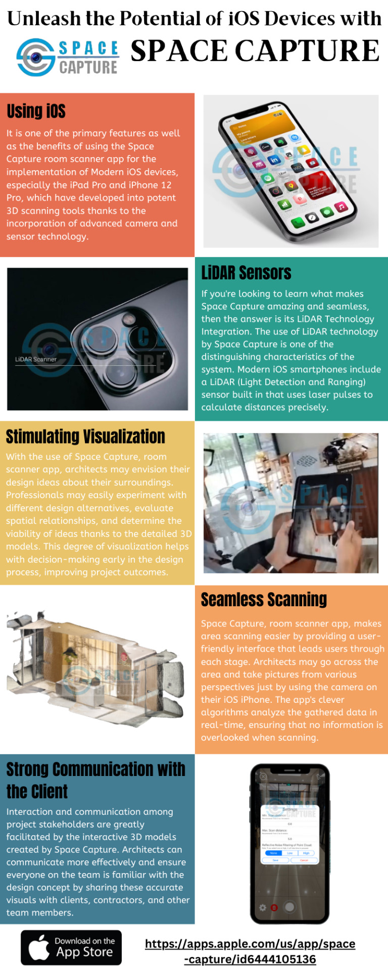
With the advancement of architecture and design, it has become critical to produce new and functional places that accurately depict real-world settings with effective LiDAR room scanner. Architects can now use the power of their iOS smartphones to scan rooms and turn them into extremely detailed 3D models, thanks to the rapid growth of technology. By producing precise point clouds that meticulously record the spatial arrangement of the environment, Space Capture advances room scanning.
#lidar room scanner#room scanning app#lidar scanning apps#lidar scanner 3d app#ios scanning app#room scanner app
0 notes
Text
CMM Inspection Services in Gujarat | The SUNCAD Training & Designers

Suncad leading CMM Inspection Services in Gujarat. We Infinity Automation Provide Outdoor as well as indoor CMM inspection services to our valuable customers. CMMs offer a reliable alternative to handheld inspection tools. They monitor the quality of manufactured items to ensure that they match original design plans within the customer’s preferred tolerance levels. CMMs can measure objects at different stages of production to quickly catch issues before the project is finished or before large-volume runs are completed, keeping the production process fast and efficient with less material waste. Under the efficient supervision of our skilled professionals, we have been able to render premium quality gamut of Faro CMM Inspection Service.
The Suncad Training & Designers provides the best CMM Inspection Services in Gujarat. For more information visit on : https://suncad.in/product/cmm-inspection/ or call us on : 9925023229
#BIM modeling and scanning service in Gujarat#3D Scanning in Gujarat#Leica RTC 360 Scanning Service Provider in Gujarat#Heritage scanning services in Gujarat#Faro Scanner Service Provider in Gujarat#3D Plant / refinery scanning service in Gujarat#D Lidar scanning / 3d Terrestrial scanning services in Gujarat#Laser tracker service in Gujarat#Reverse Engineering in Gujarat#3D Inspection services in Gujarat#CMM inspection services in Gujarat#CNC / VMC Machine operating in Gujarat#3D printing Services in Gujarat#Solid Edge training in Gujarat#SolidWorks Training in Gujarat
0 notes
Text

While using the best 3D scanner app, you will be able to scan rooms, spaces and other designs of products easily. It’s the best 3D scanner app which you can install directly with your iOS device and in a very easy way.
0 notes
Last Seen Blogs