#Pointcloud
Explore tagged Tumblr posts
Visit Tumblr Blog
Explore Tumblr blogs with no restrictions, modern design and the best experience.
Last Seen Tumblr Blogs


Fun Fact
Tumblr has 16.74 million mobile monthly users in the US.
Text
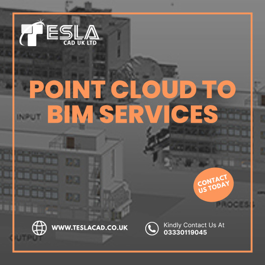
Transforming laser scans into intelligent BIM models with precision and efficiency! ➡️ 🏢 Get reliable Point Cloud to BIM services from Tesla CAD Solutions. Contact us today! 🔗 🚀
0 notes
Text
Point Cloud BIM Samples - Leveraging Point Cloud Data for BIM
Point Cloud BIM samples demonstrate how powerful 3D laser scanning can be in the design and construction industry. This innovative approach enhances the accuracy of models, reduces costly errors, and speeds up project timelines. Whether you’re working on renovation or new construction, using point cloud data ensures your project is built to precise specifications.
Explore Our Services: Point Cloud BIM Samples - Leveraging Point Cloud Data for BIM


0 notes
Text
Affordable 3D LiDAR Scanning for Construction & Engineering Projects

Looking for precise and cost-effective 3D laser scanning services? We provide high accuracy building scanning services for architects, structural engineers, civil engineers, and MEP engineers. Tejjy Inc, as one of the top 3D laser scanning companies in the USA, we deliver detailed as-built documentation, BIM integration, and site analysis for seamless construction and renovation.
1 note
·
View note

Text

#digitwin#digitaltwin#d#technology#virtualreality#pointcloud#augmentedreality#industry#iot#innovation#ai#digital#scan#cloud#automotive#design#laserscan#digitaltwins#simulation#digitaltransformation#artificialintelligence#lidar#performance#machinelearning#scenarios
0 notes
Text
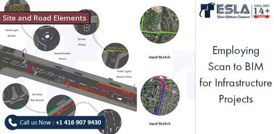
Globally, the AEC companies’ and government agencies are seeking to digitize their infrastructure in order to meet several strategic requirements of upgradations, renovations, progress monitoring and even facility management. The above complexities are further enhanced in the infrastructure projects due to the large geographical span and numerous involved stakeholders. Specifically, the renovation and reconstruction projects for infrastructure operate on tight deadlines and budget restrictions. In these situations utilizing Scan to BIM for Infrastructure would provide greater project control and allow the AEC professionals to carry out their project more efficiently. To understand the advantages of employing Scan to BIM for Infrastructure Projects, click on the link below, https://lnkd.in/erhEQvRK
#bim#bimservices#scantobimservices#aecindustry#3dlaserscanning#pointclouddata#terrestrialscanning#mobilerlaserscanning#bimmodel#pointcloud#pointcloudtobimmodel#bimservicesforinfrastructure
0 notes
Text
3D Reconstruction: Capturing the World in Three Dimensions

3D reconstruction refers to the process of capturing the shape and appearance of real objects using specialized scanners and software and converting those scans into digital 3D models. These 3D models allow us to represent real-world objects in virtual 3D space on computers very accurately. The technology behind 3D reconstruction utilizes a variety of different scanning techniques, from laser scanning to photometric stereo, in order to digitally preserve real objects and environments.
History and Early Developments
One of the earliest forms of 3D scanning and reconstruction dates back to the 1960s, when laser range scanning first emerged as a method. Early laser scanners were slow and bulky, but provided a way to accurately capture 3D coordinates from surfaces. In the 1970s and 80s, raster stereo techniques came about, using cameras instead of lasers to capture depth maps of scenes. Over time, scanners got faster, accuracy improved, and multiple scanning technologies started to converge into unified 3D modeling pipelines. By the 1990s, digitizing entire buildings or archeological sites became possible thanks to the increased capabilities of 3D reconstruction tools and hardware.
Photogrammetry and Structure from Motion
One major development that helped accelerate 3D Reconstruction was the emergence of photogrammetry techniques. Photogrammetry uses 2D imagery, often from consumer cameras, to extract 3D geometric data. Structure from motion algorithms allow one to take unordered image collections, determine overlapping features across images, and reconstruct the camera positions and a sparse 3D point cloud. These image-based methods paved the way for reconstructing larger exterior environments accurately and cheaply compared to laser scanners alone. Photogrammetry is now a widely used technique for cultural heritage documentation, architecture projects, and even film/game production.
Integral 3D Scanning Technologies
Today there are many 3D scanning technologies in use for different types of objects and environments. Structured light scanning projects patterns of lines or dots onto surfaces and reads distortions from a camera to calculate depth. It works well for industrial inspection, small objects and scanning interiors with controlled lighting. Laser scanning uses time-of-flight or phase-shift measurements to rapidly capture millions of precise 3D data points. Laser scanners excel at large outdoor environments like cultural heritage sites, construction projects and full building documentation. Multi-view stereo and photometric stereo algorithms fuse together image collections into full and detailed 3D reconstructions even with untextured surfaces.
Applications in Mapping and Modeling
3D reconstruction mapping applications are widespread. Cultural heritage sites are extensively documented with 3D models to make high resolution digital archives and share artifacts globally online. Forensic reconstruction of accident or crime scenes relies on 3D modeling to understand what happened. Engineering companies use 3D scans to digitally inspect parts for quality control. Manufacturers design products in CAD but validate and improve designs with physical prototypes that are 3D scanned. Cities are mapped in 3D with aerial and mobile scanning to plan infrastructure projects or monitor urban development over time. The gaming and animation industries also reconstruct detailed digital environments, objects and characters for immersive 3D experiences. Advancing computing power allows more complex reconstructions than ever before across many industries.
Ongoing Developments and the Future of 3D
There is continued work to improve the speed, resolution, automation and scaling of 3D acquisition techniques. Multi-sensor fusion and simultaneous localization and mapping (SLAM) is leading to capabilities like interior mapping with handheld scanners. Artificial intelligence and deep learning are also entering the field with applications like automatically registering separate scans or recognizing objects in 3D data. On the modeling side, semantics and building information models (BIM) are merging geometric shapes with metadata, properties and relationships. Advances will open the door to dynamic 3D representations that change over time, interaction with virtual objects through augmented reality and further immersive experiences in artificial worlds reconstructed from real environments. The future vision is seamlessly integrating virtual 3D spaces with our daily physical world.
Get more insights on 3D Reconstruction
About Author:
Money Singh is a seasoned content writer with over four years of experience in the market research sector. Her expertise spans various industries, including food and beverages, biotechnology, chemical and materials, defense and aerospace, consumer goods, etc. (https://www.linkedin.com/in/money-singh-590844163)
#3DReconstruction#ComputerVision#ImagingTechnology#SpatialData#DigitalModeling#Photogrammetry#PointClouds#3DScanning
0 notes
Text
Get Space Capture, the greatest Pointclouds scanning app
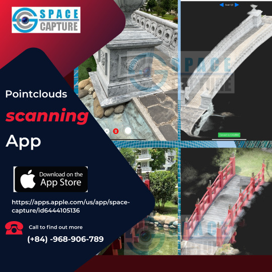
Are you searching for the best Pointclouds scanning app? Space Capture is the only option! Space Capture is the go-to choice for professionals and hobbyists looking for the best-in-class scanning tool for capturing and exploring immersive Pointclouds because to its cutting-edge technology and cutting-edge features.
#lidar room scanner#room scanning app#lidar scanner 3d app#ios scanning app#lidar scanning apps#pointclouds scanning app
0 notes
Text
Top Benefits of 3D Laser Scanning Services for Accurate As-Built Documentation & Reality Capture

Tejjy Inc. is a trusted 3D laser scanning company in the USA, offering high-resolution reality capture and accurate as-built data for various industries. Our skilled professionals deliver precise 3D scanning services, providing point cloud data, 3D models, CAD drawings, and digital twins. With an accuracy of 4-6 mm, we cater to diverse sectors, including renovation, surveying, facility management, and heritage preservation. Serving over 150 million square feet, our solutions support general contractors, architects, engineers, asset managers, and more. Whether you need building scanning, lidar services, or 3D scanning, Tejjy Inc. is your go-to for accurate, reliable results.
#3DLaserScanning#LaserScanning#ScanToBIM#3DScanning#RealityCapture#PointCloud#DigitalTwin#Surveying#Architecture#USA
0 notes
Text

genuary day 004
the original digital
computed and rendered in real time with pointcloud fx, movement detection, and a webcam in touchdesigner
#touchdesigner#generative art#generative design#artists on tumblr#digital art#motiongraphics#animation
20 notes
·
View notes
Text

pure point cloud (interior pavilion)
0 notes
Text
Dissolve - PointCloud with a Kinect sensor and body movement to particle reactivity made with TouchDesigner
#touch designer#creative coding#point cloud#sensors#kinect#artist on tumblr#artists on tumblr#l3v1at4#graphic art#graphics#works#work#animation#interactive art#visuals#interactive visuals#technology#digital arwork#digital artist#multimedia#multimedia art#glitchartistscollective#glitch#glitch art#particle simulation#glitch artists collective#GAC#glitch aesthetic
87 notes
·
View notes
Text
youtube
really cool datapack shenanigans to do pointcloud rendering in minecraft. expect it to be lagging up ur popular servers in 2024 ig
8 notes
·
View notes
Text
hate writing code but it's the only way to gain ground in the "should 'pointcloud' be abbreviated as 'pcd' or 'pcl' in our variable names" cold war
3 notes
·
View notes