#Remotesensing
Explore tagged Tumblr posts
Visit Tumblr Blog
Explore Tumblr blogs with no restrictions, modern design and the best experience.
Last Seen Tumblr Blogs


Fun Fact
In 2020, 27% of US Tumblr users had an annual household income of over $100,000.
Text


👉 Beneath the Himalayas: Unveiling the Underwater Secrets of Jammu & Kashmir with Bathymetric Surveys ✅ Bathymetric Survey in Jammu & Kashmir plays a vital role in understanding the intricate underwater terrain of this ecologically rich and strategically significant region. Jammu & Kashmir’s water bodies—from the lofty alpine lakes like Dal and Wular to the glacier-fed rivers such as the Chenab and Jhelum—serve purposes far beyond their breathtaking beauty. Call : +91 8074692090 Visit : https://slokainfrasolutions.com/blogs/bathymetric-survey-in-jammu-kashmir/
#BathymetricSurvey#UnderwaterMapping#HydrographicSurvey#LakeMapping#GeospatialData#InfrastructureDevelopment#SmartSurveying#EnvironmentalMonitoring#RemoteSensing#GISMapping#SlokaInfraSolutions#DepthMeasurement#SonarTechnology#WaterbodyMapping#SeabedSurvey#SurveyTechnology#JammuAndKashmir#Himalayas#JKTourism#KashmirLakes#IndianGeography#HimalayanWaters
2 notes
·
View notes
Text
Drone Survey in the Real World: Revolutionizing Industries with Atom Aviation
In today’s rapidly advancing world, industries across the globe are turning to drone survey technology to revolutionize the way they collect data, perform inspections, and make critical decisions. Gone are the days of traditional surveying methods that are time-consuming, costly, and labor-intensive. Atom Aviation, a leading provider of drone surveying services, is at the forefront of this transformation, providing businesses with fast, accurate, and cost-effective solutions.

What is a Drone Survey?
A drone survey is an innovative approach that utilizes unmanned aerial vehicles (UAVs) to collect data from the air. Drones equipped with cameras, LIDAR (Light Detection and Ranging), and other sensors can capture high-resolution imagery, topographical data, and 3D models of vast areas in a fraction of the time compared to traditional ground-based methods.
This data is then processed into actionable insights for industries like construction, agriculture, real estate, and more, enhancing decision-making and project planning.
The Real-World Benefits of Drone Surveys
1. Speed and Efficiency One of the main advantages of using drones for surveying is the significant reduction in time. With traditional surveying, teams would have to manually visit every corner of a site, sometimes requiring several days or even weeks for large projects. In contrast, drones can complete the same tasks in hours, allowing businesses to access crucial data quickly and make decisions faster.
2. Cost-Effectiveness Drone surveying reduces the need for expensive equipment like helicopters or cranes used in traditional aerial surveys. Additionally, fewer personnel are required to operate the drones, further lowering costs. Atom Aviation ensures that businesses can enjoy these cost savings without compromising on the accuracy or quality of the data collected.
3. High-Resolution Data Drones are equipped with high-definition cameras and specialized sensors that capture data with exceptional precision. Whether it’s topographical mapping, volumetric analysis, or landscape modeling, drones provide a level of detail that is difficult to achieve with manual methods. This is especially crucial in industries like construction, where accurate measurements are essential for project success.
4. Access to Hard-to-Reach Areas In many industries, there are locations that are difficult to access using traditional surveying methods due to safety concerns or physical barriers. Drones can easily navigate hazardous environments, such as construction sites, power lines, or agricultural fields, ensuring that no area is left unexamined.
5. Minimal Disruption Unlike ground-based surveying, which may require disturbing the environment or disrupting normal business operations, drone surveys are non-invasive. They can operate without disturbing ongoing work, making them ideal for active construction sites or agricultural fields.
How Atom Aviation is Leading the Charge
Atom Aviation is a company that has harnessed the full potential of drone surveying to offer customized solutions for businesses across various sectors. With their fleet of state-of-the-art drones and highly skilled pilots, Atom Aviation ensures that every project, no matter how large or small, is completed with precision and efficiency.
Atom Aviation’s drone surveying services have been particularly valuable in the following industries:
Construction: From land surveys to site inspections, drones help construction companies keep projects on track and ensure compliance with building codes and regulations.
Agriculture: Drone surveys allow farmers to monitor crop health, assess soil conditions, and make data-driven decisions to maximize yield.
Real Estate: Property developers and real estate professionals use drone surveys to create accurate 3D models and aerial maps of properties, helping to market developments and make informed investment decisions.
Infrastructure: Drones enable inspectors to assess bridges, powerlines, and pipelines, identifying potential issues without the need for dangerous manual inspections.
Why Choose Drone Surveying with Atom Aviation?
Choosing the right provider for drone surveying is crucial to getting accurate, reliable results. Atom Aviation stands out for several reasons:
Advanced Drone Technology: Atom Aviation uses the latest drones equipped with cutting-edge cameras and sensors for precise data collection.
Expert Team: Their team consists of certified drone pilots and experienced surveyors, ensuring that all data is collected safely and accurately.
Tailored Solutions: Whether you need topographic surveys, volumetric analysis, or 3D mapping, Atom Aviation offers services customized to meet the unique needs of your project.
Timely Delivery: With a commitment to efficiency, Atom Aviation delivers survey data quickly, enabling businesses to make decisions without delays.
Conclusion
The application of drone surveys has brought about a significant change in how businesses approach data collection and site analysis. With companies like Atom Aviation leading the way, industries now have access to faster, more cost-effective, and highly accurate surveying methods that enhance productivity and decision-making. Whether you're in construction, agriculture, real estate, or infrastructure, Atom Aviation is the partner you need for cutting-edge drone surveying solutions.
For more information on how Atom Aviation can assist with your next drone survey, visit their website today and discover how they can take your business to new heights!
Keywords Used:
Drone survey
Atom Aviation
Drone surveying services
#drone#drone survey#drone surveying#dronetober#survey#mining#AerialSurveying#DroneData#ConstructionSurveying#TopographicMapping#AtomAviation#UAVSurvey#3DMapping#LandSurveying#RemoteSensing
2 notes
·
View notes
Text
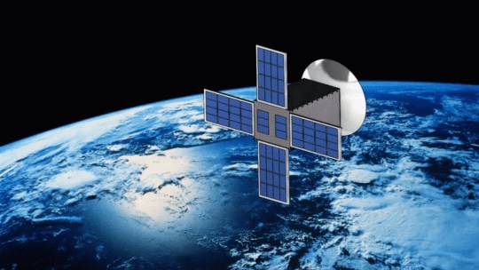
Small Satellite Market Drivers Include Demand for Earth Observation and Low-Cost Launch Solutions
The Small Satellite Market is experiencing a paradigm shift, primarily driven by the soaring need for Earth observation capabilities and the emergence of low-cost launch options. This combination is making space more accessible, allowing government agencies, private firms, and research institutions to capitalize on the advantages of compact satellite technologies. With the increasing affordability and technical feasibility, small satellites are disrupting traditional satellite development cycles and reshaping the future of global satellite services.
Surge in Earth Observation Applications
Earth observation has emerged as one of the most critical uses of small satellites. Whether monitoring climate change, analyzing agricultural productivity, or managing natural disasters, small satellites provide high-resolution imagery and data in near real-time. This capability allows for data-driven decision-making across sectors such as:
Agriculture: Monitoring crop health and predicting yields
Urban Planning: Tracking infrastructure development
Environmental Monitoring: Assessing deforestation, pollution, and water cycles
Disaster Management: Supporting emergency response during floods, wildfires, and hurricanes
Governments and commercial enterprises alike are leveraging small satellites to achieve these outcomes with unprecedented frequency and geographic coverage.
Cost Reduction and Miniaturization
Historically, space missions were prohibitively expensive and monopolized by national space agencies. Today, miniaturization and advances in electronics have reduced payload sizes without compromising performance. These compact payloads drastically lower the cost per mission and allow for more frequent launches.
Several contributing cost drivers include:
Standardized CubeSat architectures
Commercial off-the-shelf (COTS) components
Shared launch services (ride-sharing missions)
Reusable launch vehicles (e.g., by SpaceX and Rocket Lab)
By lowering the financial barrier to entry, small satellites are attracting a wide array of stakeholders, from startups to universities.
Enabling Commercial and Defense Capabilities
Commercial organizations are deploying satellite constellations for services ranging from broadband internet to global asset tracking. Notable developments include:
Communications: Providing global internet connectivity to underserved regions
Logistics: Tracking containers, cargo, and vehicles in real-time
Insurance: Monitoring assets for risk evaluation and loss mitigation
On the defense front, countries are investing in small satellites to bolster surveillance, intelligence, and navigation capabilities. These satellites are often easier to launch and replace, enhancing operational agility during geopolitical conflicts or emergencies.
Integration With Ground Infrastructure
The usability of small satellite data depends heavily on ground-based processing and communications infrastructure. Market drivers are amplified by developments in:
Ground stations: More numerous and interconnected stations allow for faster data downlink.
Data analytics platforms: AI and machine learning help in processing the deluge of incoming satellite data.
Cloud-based storage and delivery: Seamlessly integrating satellite imagery with end-user platforms like GIS systems.
These developments ensure that the advantages gained in orbit are fully realized on Earth, enhancing the overall efficiency of satellite applications.
Growing Support From Governments and Agencies
Global governments are stepping in to support small satellite missions through:
Funding: Subsidies, grants, and public-private partnerships
Regulations: Streamlining licensing and orbital assignment procedures
Infrastructure: Investing in spaceports and testbeds
Agencies like NASA, ESA, ISRO, and JAXA are integrating small satellite missions into their strategic goals, further validating their critical role in space innovation.
The Domino Effect of Launch Service Providers
Low-cost launch providers are the backbone of the small satellite boom. Companies such as Rocket Lab, Firefly Aerospace, and Virgin Orbit are offering tailored solutions for smaller payloads. Their entry has intensified competition and driven launch prices downward. Additionally, these providers offer more flexible scheduling, enabling organizations to plan launches without waiting for larger missions to align.
Strategic Collaborations and Ecosystem Expansion
The collaborative ecosystem around small satellites is robust. Manufacturers, component suppliers, launch firms, and analytics companies are increasingly forming joint ventures to offer end-to-end solutions. Strategic partnerships allow:
Faster time-to-market
Integrated data delivery solutions
Broader international market access
This ecosystem is especially advantageous for new entrants lacking in-house technical or financial resources.
Conclusion: Transitioning Into Trend-Driven Development
As demand for Earth observation and cost-effective launch continues to intensify, the Small Satellite Market is poised for sustained growth. The convergence of affordability, accessibility, and application diversity is making these systems indispensable. Looking ahead, market trends such as satellite miniaturization, rapid deployment, and AI-driven analytics will further shape the competitive landscape—topics we’ll explore in the next article of this series.
#SmallSatelliteMarket#EarthObservation#LowCostLaunch#CubeSats#SatelliteTechnology#SpaceInnovation#MiniSatellites#RemoteSensing#DefenseSatellites#NewSpace#SatelliteLaunch#SpaceTech
0 notes
Text

Tired of Clunky GPS Data Workflows? Try QGIS 3 at UDEMY!
Learn how to manage GPS data effortlessly using QGIS 3 with this easy-to-follow course.
Discount 43% ($12.99 From $22.99)
0 notes
Text
#RemoteSensing#AIDetection#SmallTargetDetection#SatelliteImagery#FPGA#EnergyEfficientAI#EnvironmentalMonitoring#DisasterResponse#DeepLearning#RealTimeDetection#AIEdgeComputing#Drones#ForestMonitoring#FloodDetection#SpaceTech#GeospatialIntelligence#EarthObservation#SmartSatellites#ImageProcessing#TechBlog
0 notes
Text
Job - Alert 🌎
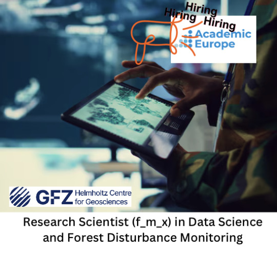
🌍 We're hiring! Join GFZ – Germany’s National Centre for Solid Earth Research
🚀 Research Scientist (f/m/x) – Data Science & Forest Disturbance Monitoring
Are you passionate about Earth observation, forest ecosystems & AI? Work at the intersection of remote sensing, machine learning & sustainability to advance global forest monitoring with Sentinel, GEDI & hybrid modeling.
🔬 Collaborate with top scientists from GFZ Helmholtz-Zentrum für Geoforschung, Technische Universität Berlin & Humboldt-Universität zu Berlin
🛰️ Use advanced EO data & ML to detect forest disturbance & climate-related risks
📍 Work in beautiful Potsdam – at the cutting-edge of Earth system research
🗓️ Apply by 1 June 2025
🔗 More info & apply now: https://www.academiceurope.com/job/?id=7631
0 notes
Text
How Satellite Imagery is Revolutionizing Disaster Management
Natural disasters strike without warning — but with satellite imagery, response teams can act faster and smarter. Check out Satpalda’s latest blog: “Applications of Satellite Imagery in Disaster Management” Discover how real-time Earth observation helps save lives, assess damage, and support rapid recovery.👉 Read the full article: https://satpalda.com/applications-of-satellite-imagery-in-disaster-management/
1 note
·
View note
Text

Revolutionizing Farming with Drone Technology!
Say goodbye to traditional farming hassles! Introducing [Your Company Name] Agriculture Drone Services – the future of precision farming.
✅ Crop Health Monitoring ✅ Pesticide & Fertilizer Spraying ✅ Aerial Mapping & Survey ✅ Time & Cost Efficient
📍 Accurate. 🌱 Eco-Friendly. 💸 Saves Time & Labor.
👨🌾 Whether you're a small-scale farmer or manage vast acres, our drone solutions help you make smarter, faster, and more sustainable decisions.
For more information visit: https://bit.ly/3VP62Ht
#AgriDrones#DroneFarming#PrecisionAgriculture#SmartFarming#AgriTech#FarmTech#DroneSpraying#CropMonitoring#AerialSurvey#FarmingInnovation#SustainableFarming#DroneServices#ModernFarming#AgriSolutions#DigitalFarming#TechInAgri#FarmAutomation#YieldBoost#FarmingFuture#RemoteSensing#DroneMapping#AgroDrone#FarmDrone#AgriDroneServices#NextGenFarming#DroneTechnology
0 notes
Text
I'm excited to share my latest in-depth analysis on how Geographic Information Systems are revolutionizing defense operations worldwide. As the author of "Mapping Tomorrow: Navigating to the World of Geographic Information System," I've explored how cutting-edge geospatial technologies are transforming military capabilities across multiple domains. In this comprehensive blog post, I examine six critical case studies that demonstrate the strategic impact of advanced GIS implementation: Indo-Pacific Maritime Domain Awareness systems integrating satellite surveillance with oceanographic modeling Humanitarian demining operations enhanced through AI-driven terrain analysis and probability mapping Urban warfare planning revolutionized by high-fidelity 3D modeling and subsurface infrastructure mapping South Asian border security monitoring leveraging multi-sensor integration and cross-border incident mapping Military humanitarian assistance powered by damage assessment automation and resource optimization Electromagnetic spectrum operations treating digital signals as mappable terrain The article also explores emerging trends that will shape the future of defense GIS, including quantum computing applications, edge computing for disconnected operations, and advanced human-machine teaming in spatial analysis. As conflicts become increasingly complex and multi-domain, superior geospatial intelligence has emerged as a decisive factor in both conventional military operations and asymmetric warfare. The organizations that most effectively leverage these capabilities will maintain significant advantages in our increasingly contested world.
View On WordPress
#ai#aiindefense#artificial-intelligence#asymmetric warfare#battlespace management#command and control systems#common operating picture#defensemapping#defensetechnoloy#dronemapping#education#environment#force multiplier technologies#force protection#geographicinformationsystems#geoint#geospatialinelligence#gis#intelligence fusion#intelligence preparation of battlefield#lidar#military decision support systems#military modernization#militaryapplications#multi-domain operations#operational planning#predictiveanalysis#RemoteSensing#strategic intelligence#technology
0 notes
Text
Industrial Sensors for Temperature Monitoring Australia
Temperature monitoring is crucial in modern industries. In Australia, businesses rely heavily on accurate and durable sensors. Whether it is food processing, mining, manufacturing, or pharmaceuticals, having the right sensor ensures safety, quality, and efficiency. Industrial sensors for temperature monitoring Australia offer precise control and real-time data needed for critical operations.

Industrial Sensors for Temperature Monitoring Australia In this article, we dive deep into how industrial sensors for temperature monitoring Australia are transforming industries. We will also look at their types, technical features, applications, and buying tips.
Importance of Industrial Sensors for Temperature Monitoring Australia
Industrial sensors for temperature monitoring Australia serve as the backbone for many systems. They help in maintaining the right temperature for machines, products, and environments. Without these sensors, industries would face equipment failures, production losses, and safety risks. Australian industries operate in extreme conditions. From the scorching heat of mining zones to the cold storage of pharmaceuticals, temperature variations are common. Thus, reliable sensors are not a luxury but a necessity. Companies today aim for accuracy within fractions of a degree. This is where high-quality industrial sensors for temperature monitoring Australia come into play.
Key Features of Industrial Sensors for Temperature Monitoring Australia
Modern industrial sensors used in Australia are packed with technical features. Here are some common characteristics: - High Accuracy: Precision up to ±0.1°C in many models - Wide Temperature Range: Some can measure from -200°C to +1200°C - Robust Design: Resistant to dust, water, and corrosion - Real-Time Monitoring: Instant data transmission - Integration with IoT: Smart systems for predictive maintenance Industries demand not just measurement but reliable data under harsh conditions. Industrial sensors for temperature monitoring Australia are designed to meet these demands.
Types of Industrial Sensors for Temperature Monitoring Australia
There are different types of sensors used across Australian industries. Each has its strengths and specific use cases.
Thermocouples
Thermocouples are one of the oldest and most trusted types. They work by measuring voltage changes between two dissimilar metals. - Advantages: Wide range, rugged, inexpensive - Disadvantages: Less accurate compared to RTDs Thermocouples are heavily used in mining and metal industries in Australia.#IndustrialSensors, #TemperatureMonitoring, #AustraliaSensors, #IndustrialAutomation, #SmartSensors, #SensorTechnology, #TemperatureControl, #ProcessMonitoring, #IndustrialEquipment, #RemoteMonitoring, #IndustrialIoT, #SmartManufacturing, #TemperatureSensors, #IndustrialTemperatureMonitoring, #MonitoringSolutions Read the full article
#Australia#Automation#IndustrialEquipment#IndustrialSensors#IoTSensors#ProcessMonitoring#RemoteSensing#SensorSolutions#SmartManufacturing#TemperatureMonitoring
0 notes
Text

High-quality rooftop labeling for geospatial dataset
We deliver precise, scalable, and reliable rooftop data annotation services that power next-gen AI applications — from smart city infrastructure to solar tech and urban planning.
Our experienced team ensures:
Accurate polygon labeling
Rapid turnaround at scale
Enterprise-grade QA
Secure, NDA-bound operations
Working with startups, government projects, and enterprise clients alike - we help you focus on innovation while we take care of the data.
Let’s build smarter systems, together - one rooftop at a time.
Message us or email at [email protected] to learn more. www.wisepl.com
#DataAnnotation#GeospatialAI#UrbanMapping#SmartCity#RooftopLabeling#ImageAnnotation#AITraining#SatelliteImagery#ComputerVision#StartupIndia#GIS#RemoteSensing#AIForGood#Wisepl#MachineLearning#AI
0 notes
Text
Ultimate Guide to Dissolved Oxygen Sensors: How DO Sensors Work & Why They Matter
Discover everything you need to know about Dissolved Oxygen (DO) sensors — from how they work to where they’re used in industries like aquaculture, wastewater treatment, and environmental monitoring. This guide covers sensor types, key applications, and tips for accurate DO measurement.
Chlorophyll Sensor: Revolutionizing Environmental Monitoring
Dissolve Oxygen Sensor: Guide to DO Sensors
Digital pH Sensor: Precision Monitoring Solutions
Digital pH Sensor: Ultimate Guide for Accurate Measurements
#ChlorophyllSensor#ChlorophyllDetection#SensorTechnology#EnvironmentalMonitoring#SmartSensors#PlantHealth#PrecisionAg#RemoteSensing#IoTDevices#Agritech
0 notes
Text
Tired of Clunky GPS Data Workflows? Try QGIS 3 at UDEMY!
Learn how to manage GPS data effortlessly using QGIS 3 with this easy-to-follow course.
Discount 43% ($12.99 From $22.99)
0 notes
Text
Protect Your Land with Smart Encroachment Detection!
Safeguarding your land goes beyond ownership—it requires proactive monitoring. With LAMS, detect unauthorized encroachments in real-time using advanced satellite imagery, drone data, and AI-driven analysis. Stay ahead with regular monitoring and ensure your land remains secure!
Know more at https://lamsapp.com/services/land-encroachment-detection
#LandProtection#EncroachmentDetection#SmartLandManagement#LAMS#GISMapping#LandMonitoring#RemoteSensing#LandSurveillance#PropertySecurity#GeospatialSolutions#DroneMapping#SustainableLandUse#SmartLandTech
0 notes
Text
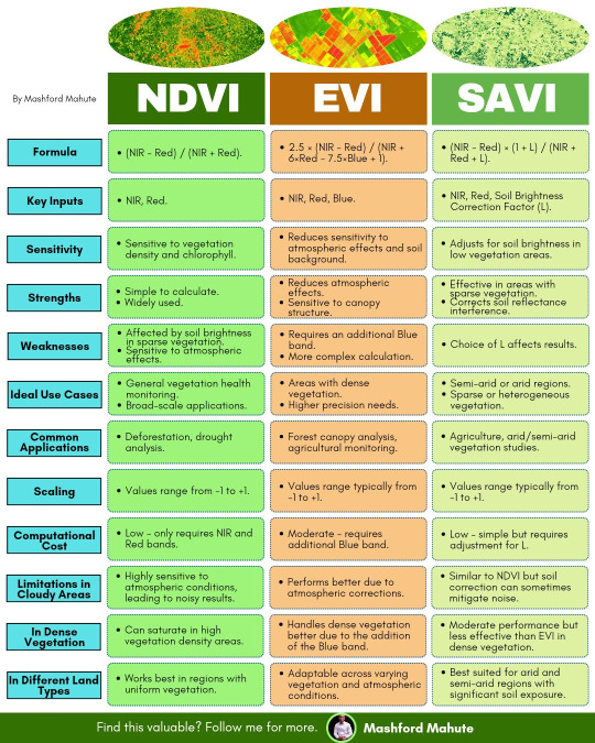
#NDVI#EVI#SAVI#GIS#RemoteSensing#Geospatial#QGIS#ArcGIS#DataViz#vegetation#infographic#Remote Sensing#satellite
0 notes
Text
Job - Alert 🌎

🌍 Join GFZ as a Postdoc in Remote Sensing and Geoinformatics! 🌍
GFZ Helmholtz-Zentrum für Geoforschung is seeking a dedicated Postdoctoral Researcher (f_m_x) for our project on multi-scale LIDAR and European biomass monitoring. This position offers the opportunity to contribute to groundbreaking research in Earth observation and climate action.
📅 Start Date: May 1, 2025
🗓️ Application Deadline: April 22, 2025
Become part of our dynamic team at the GFZ Helmholtz Centre for Geosciences in Potsdam and help us tackle global challenges!
👉 For more details and to apply, check our website: https://www.academiceurope.com/job/?id=7263
0 notes