#Wonderland Trail
Text
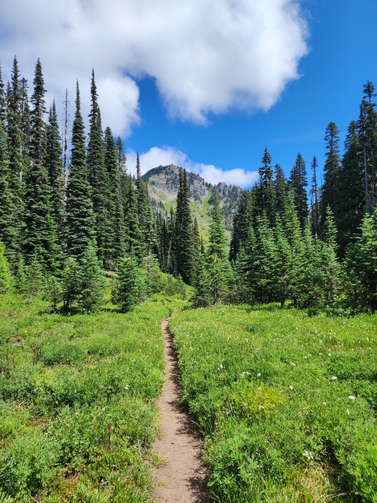
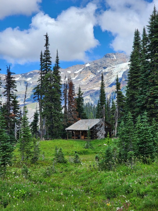
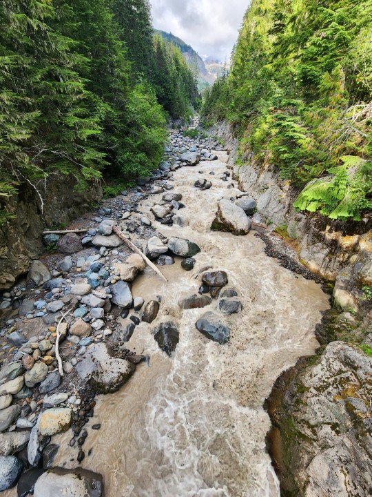


MILE 1-32 ~ THE WEST SIDE
AUGUST 8-10, 2023
#wonderland trail#pnw#washington#pacific northwest#outdoors#cascades#hiking#mount rainier#pnwonderland#washington state#national parks#mt rainier national park#mount rainier national park#mt rainier
282 notes
·
View notes
Text
National Historic Preservation Month - Trails
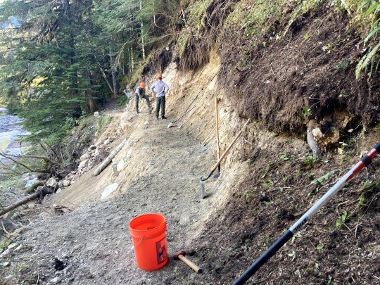
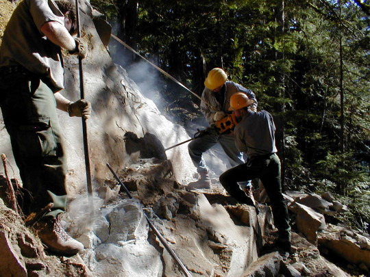
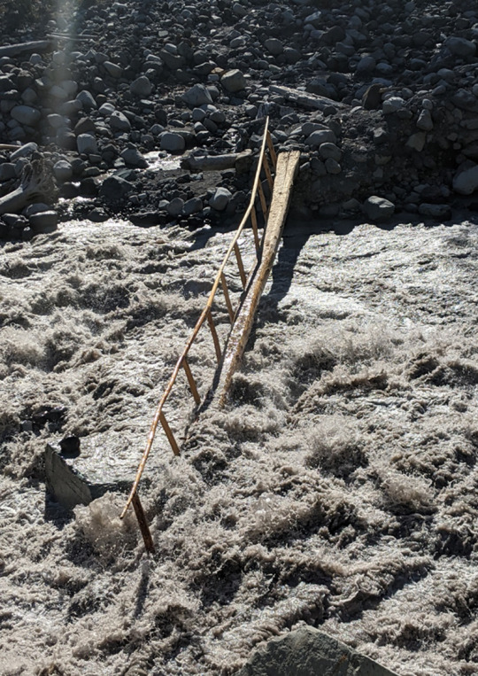
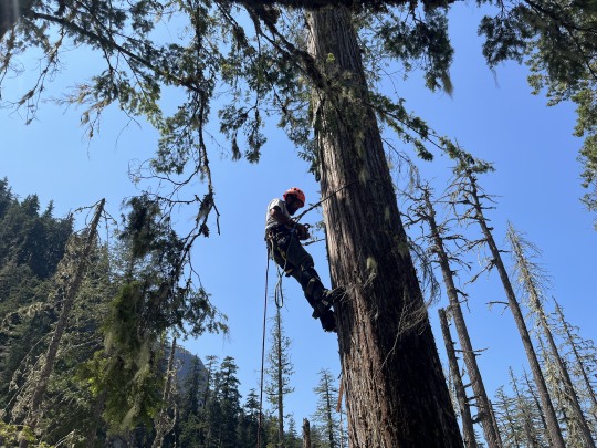
Did you know that Mount Rainier’s Wonderland and Northern Loop Trails are also considered part of the National Historic Landmark District? The first version of the around-the-mountain trail was completed in 1915, at a lower elevation than the current version. Although it has been relocated in places and maintained and rebuilt when required, the Wonderland Trail as a whole has extensive integrity and is one of the most significant and historic trails in the national park system. The trail’s integrity is thanks to a dedicated and hardworking trail crew that works every year to maintain trails throughout the park. On this dynamic mountain, foot bridges frequently wash out, sections slide way, rocks need to be cleared, and more. The park is also 97% designated Wilderness, so often trail crews are doing this repair work without any equipment besides what they can carry in. Have you seen trail crews at work while out hiking or volunteered with a trail crew?
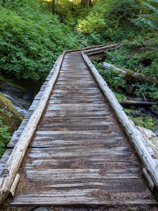
NPS Photos: Trail crew members rebuild a section of trail that had washed out on the Wonderland near Carbon River. Crews drill rocks along a section of the Northern Loop Trail. A washed-out footbridge over the Carbon River. A crew member climbs a tree to install a high lead rigging system to lift a log to place it across a river crossing. A section of wood boardwalk at Doe Creek along the Wonderland Trail after 10 years.
#Historic Mount Rainier#National Historic Preservation Month#Wonderland Trail#Northern Loop Trail#trail crew#trails#trail maintenance#history
25 notes
·
View notes
Text

The Wonderland Trail, Acadia National Park, Maine
Photo By Ryo Chiba
8 notes
·
View notes


Text

Northwest Side of Mt. Rainier from Wonderland Trail, Washington, 2002.
The Wonderland Trail encircles the volcano, and it is a popular backpacking route. The whole circuit is 150km and takes more than a week to properly enjoy. When the weather is good, the views are awesome, but ...
#landscape#mountains#glacier#hiking trails#mt rainier national park#wonderland trail#pierce county#washington state#2002#photographers on tumblr#pnw#pacific northwest
30 notes
·
View notes
Text
Transform Your Weekend: The Ultimate Hiking Trails Near You
#Appalachian Trail#Bryce Canyon Rim Hiking Trail#Continental Divide Trail#Franconia Ridge Loop#Grand Canyon#Hiking Trails#John Muir Trail#Kalalau Trail#Pacific Crest Trail#South Kajson Kaibab to Bright Angel Trail#Teton Crest Trail#Wonderland Trail
0 notes
Text
Yuu walks into the Lounge to see Jade trying to manhandle a eel form Floyd as Azul stands nearby with a few buckets. They freeze when they see Yuu and Floyd scrambles out of Jade's hold and slithers over to Yuu to hide behind her. She gets a crash course in learning what Vil uses for his facial cream. Yuu gets Azul to give her the buckets, picks up Floyd, and says she'll be back.
Yuu returns with twice as many buckets, leaving Azul stunned and asking how she managed that.
"I just massaged him. No need for wringing him dry or anything. He had a lotta knots in his back."
Jade and Azul stare at her before Jade asks:
"...Can I be chosen next?"
Floyd ends up being very docile and out of it for the next few days.
#twisted wonderland#twst yuu#yuu homura#azul ashengrotto#jade leech#floyd leech#twst rambles#have the mental image of Floyd slithering around on the ground like snake and leaving a mucus trail behind in the lounge
1K notes
·
View notes
Text
100 Miles on the Wonderland Trail
Earlier this year, during spring 2022, I signed up for two lotteries that would grant me passes to backpack on either The Wonderland Trail or The Enchantments. The Enchantments is 21 miles. The Wonderland Trail is 100.
Guess which lottery I won?
Regardless of whether I thought I could do it or not, winning that lottery gave me no choice but to say yes. The park grants around 600 reservation-based permits every year.
It’s pretty intimidating to organize because you have to reserve all your campsites in advance, and it feels like waiting on your computer browser to register for the best classes you want. To my advantage and blessing, one of my best friends happens to be a map nerd—yup, they’re out there guys. They are out there and thriving! Thanks to his wisdom (and the handy dandy Nat Geo paper maps), after calculating the elevation and terrain of the land, he patiently sat with me on a Saturday morning in April, MONTHS before the start date, to help me pick out the best spots. And so, with five other people crazy enough to join me on this journey, we spent 9 days in August ditching our jobs, phones, and “real-world problems” to conquer 100 miles around the base of Mount Rainier.
We didn’t do any training beforehand. If anything, it was a chance to carb load as hard as we wanted because we knew that we were going to be eating nothing but dehydrated food and Clif Bars—so might as well enjoy what we had now! We even car camped the night before with friends who weren’t joining, destroying breakfast burritos and sipping on beers.
That being said, it was a late and ROUGH start on trail the next day. With unusually hot temperatures, we scaled nearly 2,000 feet of elevation at three in the afternoon, only to go straight back down at a knee-banging angle. Little did we know that that was going to be the pattern for every single day onward. Mosquitos were flying, sweat was compiling, and we didn’t get to our first campsite till after 9 p.m.
Several of us were definitely wondering what the heck we got ourselves into, but as the next couple days continued, we got our “trail legs” on. We learned to wake up before 7:30 and when it was time to go at our own paces. The heat subsided as we reached the northern side of the mountain, with wildflowers in full bloom and black bears grazing on days 3 and 4. The “wonderland” part of the Wonderland Trail began to settle in, and the further I wanted to escape within it. It became odd to hike on stretches of the trail that were open to the greater public of the park. We walked alongside day visitors covered in dirt with our giant backpacks while families and kids were prancing around with ice cold sodas and clothes that didn’t smell of crusty sweat and dust.
I couldn’t tell you how many running jokes came out of the trip, but I can tell you that I probably lost a couple pounds from how hard I laughed throughout The Wonderland Trail. I couldn’t begin to convey to you just how difficult the trail was, even after we had gotten into better shape. There’s 22,000 feet of elevation gain total, which left us with blisters and knee problems left and right. When I’d finally post up for the night (which is NOT right in front of a great view, for any non-backpackers reading this who see picturesque photos of campsites on social media), I’d knock out as soon as my head hit the pillow—and I’m a pretty light sleeper. Yet, despite all of this, I got to bond so deeply with our group, in a way that we will probably never get to do again. 9 days nonstop with the same people. Half of whom didn’t know each other super well prior to this trail. And yet, here we were by the end of it cracking stupid jokes, using the bathroom in front of each other, and just being plain gross together.
So by the time it got to day 7, when several of us were thinking about finishing the trail a day early, I wasn’t ready to leave. This year has probably been one of the most stressful and anxiety-ridden years of my life since 2015. My search for “the next move” in my career and my life begins to weigh on me harder as inflation continues to pressure everyone to do anything to stay afloat, and I’m constantly doubting what I’ve been doing to get where I am today. Being on this hiking trail, in the best shape I’d ever been by the end of it, without a phone whose emails are blowing up, and with some of the most genuine people I’ve ever met, I wasn’t ready to go back into all of that.
Yet, that’s what we ended up doing on the last day. And boy, did it feel good to sit in a car and drive it 10 miles at a quicker pace than it’d take to hike the same distance. We crawled to the McMenamin’s and ate our burgers and drank our beer, as is customary in post-hike culture. We drove home, and as the cold hardwood floors touched my feet, it felt foreign to stand on compared to the soft dirt of the trail. I avoided turning on my phone for hours, already aching at the thought of what might await me on the other end.
So here we are months later, and reflecting on the experience, I wonder why I only backpacked two trails this year. Life during/after/during-after covid has been so fast-paced, everything all at once. As I get older I realize how much harder it’s going to be to get to do things like this; just disappear for awhile, but with people I love.
I still don’t really know what the future holds, but for now I know that I’m capable of doing something as insane as this. And it may indeed continue to be hard to get out there as often as life continues to speed up, but I can’t wait until the next experience, and I will certainly do whatever I can to make sure I never lose those same feelings of escapism and gratitude when I get out there.
1 note
·
View note
Text

#posting this from the grave btw#i don't even have words for how i feel about this image i just-#raaaaaaaahhhh!!!!#joe keery#did my best to enhance his blurry face with my many editing apps lmao but his happy trail wouldn't focus 😔#Joe Keery Wonderland#m
153 notes
·
View notes
Text
⚔️🐬
#10!! they are going on a mountain trail PICNIC because i SAID SO!!!!! theyll use the empty basket to collect foraged plants (mushrooms)#i drew jade for one of my twst zine pieces and Also gave him this same hat. idk why it has such a vice grip on my brain for him#it feels right. i hate drawing jade (i love drawing jade) i am conflicted. he is SO cute and i always think it looks good but its tricky#maybe thats why i do the hat. idk. also ponytail silver Real. wait till tomorrow. giggles cutely#unrelated also but im dealing with some. really heavy irl stuff. so sry if i dont rly reply to comments on these posts. i normally try :(#friends can eitherrrr check my twt for what happened or dm on discord but. sighs. im stuck in a cycle not of my own making. hate it here#twst#twisted wonderland#twst silver#jade leech#suntails
525 notes
·
View notes
Text


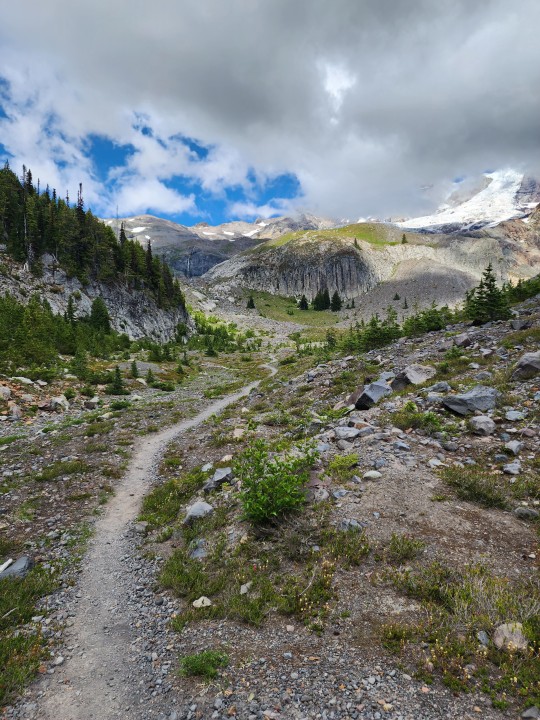
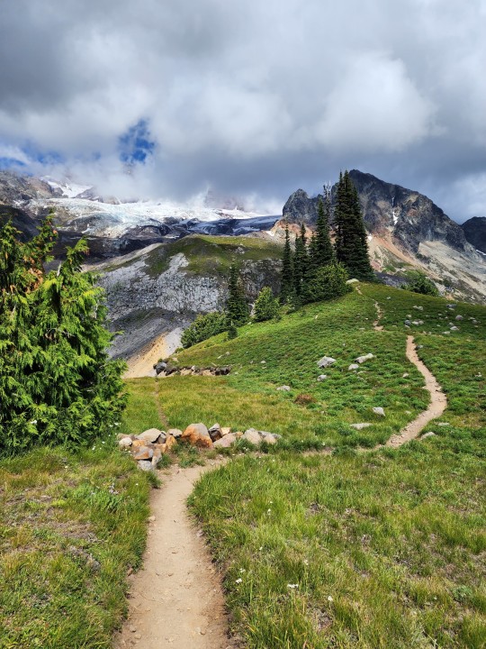
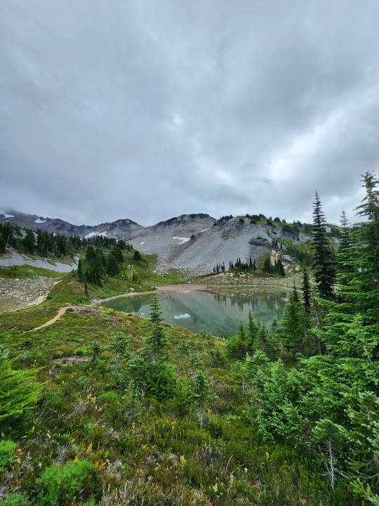
MILE 33-57 ~ THE NORTH SIDE
AUGUST 11-12, 2023
#wonderland trail#pnw#washington#pacific northwest#outdoors#cascades#hiking#mount rainier#pnwonderland#washington state#national parks#mt rainier national park#mt rainier#mount rainier national park
120 notes
·
View notes
Text
As Autumn spins round towards winter, finding a place to get out for a hike can get more challenging. At Mount Rainier National Park, few roads stays open throughout the winter due to weather, snow, and avalanche risks. One road that does stay open (weather permitting) is the road from the Nisqually Entrance (on State Route 706 near Ashford) running 7 miles up to Longmire.

If you head out to Longmire for some outside time, you can find information and a friendly park ranger at the Longmire Museum. Across the access road from the Museum, is a trailhead for part of the Wonderland Trail. This trail section can be good for a hike or snowshoe (once there’s enough snow).

Starting from the trailhead, you wander up the Wonderland Trail 1.7 miles up to the next trailhead, across from the Cougar Rock Campground (closed in winter). This is a lovely stroll through the forest. Look up and see the douglas-firs soar into the sky. With views of the Nisqually River, hikers can gain an appreciation for this braided river. The multiple channels of the river roam back and forth across the river bed.

At the trailhead near Cougar Rock, you come into an opening with a great view across the Nisqually River to Eagle Peak. This is a great spot turn to around and head back down the Wonderland trail to Longmire. Please stay off the road. Even when closed to the public, park snow plows may be out working, clearing snow from the road. It is not safe to hike or snowshoe on the road. And why should you? This beautiful section of the Wonderland trail is a great hike or snowshoe.

When was the last time you hiked or snowshoed the Wonderland trail from Longmire to Cougar Rock? Do you think it is better in the snow or snow-free? ~ams
For more information about Longmire and the trail, you can start with this webpage https://www.nps.gov/mora/planyourvisit/longmire.htm and https://www.nps.gov/thingstodo/explore-longmire-in-winter.htm. Check the weather before hiking https://www.nps.gov/mora/planyourvisit/weather.htm. And please remember that tire chain requirements start November 1. For more information https://www.nps.gov/mora/planyourvisit/tire-chain-faq.htm . Winter road updates available at https://twitter.com/MountRainierNPS .
These photos are from years past. NPS/Spillane Photo. Metal sign and post on Wonderland Trail in Longmire. Dirt trail leading away and uphill through forest. July, 2015. NPS/Spillane Photo. Snow-covered Wonderland trail through forest between Longmire and Cougar Rock. February, 2014. NPS/Spillane Photo. View from Wonderland Trail through forest to Nisqually River. Snow covers ground and trees. Several channels of river visible. February, 2014. NPS/Spillane Photo. View from Cougar Rock trailhead of the Wonderland Trail looking across the Nisqually River to the trees and cliffs of Eagle Peak. Snow covers the ground and trees. December, 2012.
#encuentra tu parque#find your park#hiking#trail#wonderland trail#national parks#mount rainier national park#forest#Nisqually River
31 notes
·
View notes
Text

My dream role is Davey Jacobs!
(Tell me yours in notes/tags)
#theater kid#theater kids#musical theatre#hamilton#newsies#into the woods#broadway#musical#broadway musicals#west end#in the heights#something rotten#the guy who didn't like musicals#falsettos#the trail to oregon#newsies musical#newsies broadway#starkid npmd#starkid productions#starkid#beetlejuice#heathers#sound of music#twisted#wonderland musical#dear even hanson#avenue q#little shop of horrors#beetlejuice musical#beetlejuice lydia
354 notes
·
View notes
Text
I want all the characters in TWST to have happy trails...
#I have a really thick and bushy happy trail despite the rest of the hair on my body being pretty light#and it's the most physically attractive thing in the world to me#twst#twisted wonderland
85 notes
·
View notes
Text

I was noooot happy with my last Jack drawing, so I did a bunch of studies and drew another XP
And yes fellow perverts, there is a nude version available. Two actually. One with fluff and a hairless version for those who, for reasons beyond my personal understanding, prefer their wolf-men clean shaven.
Enjoy ~
#I mean wolves are VERY fluffy creatures#stands to reason a wolf-man would be similar#I'll be over here enjoying the happiest trail ever#each to thier own and all that#twst#is my art#twisted wonderland#jack howl
87 notes
·
View notes
Text

Photo by Amandine CORGIER-PERRETANT on Unsplash
97 notes
·
View notes
Last Seen Blogs

keitsuron
— OF JUSTICE !

joonkael-blog
fly

keopi-taeyeon
snsd

velurtilesceramics
Tiles And Ceramics In Namakkal – Velur Tiles

believers4ever
BELIEVERS4EVER.COM