#aerial map
Text

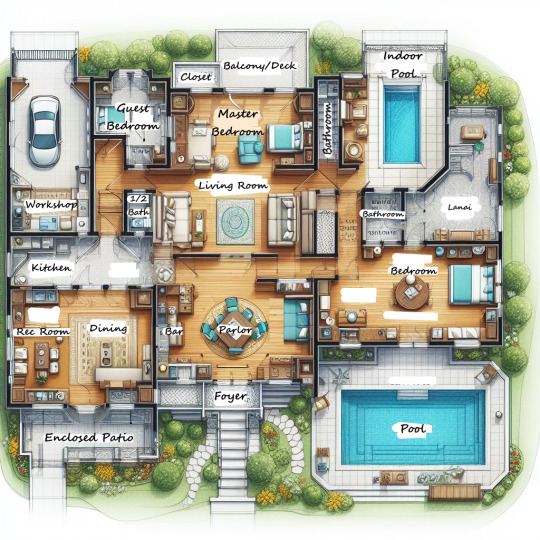

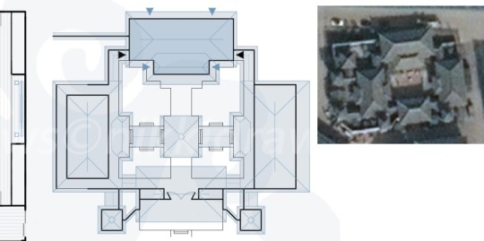
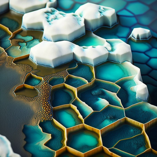
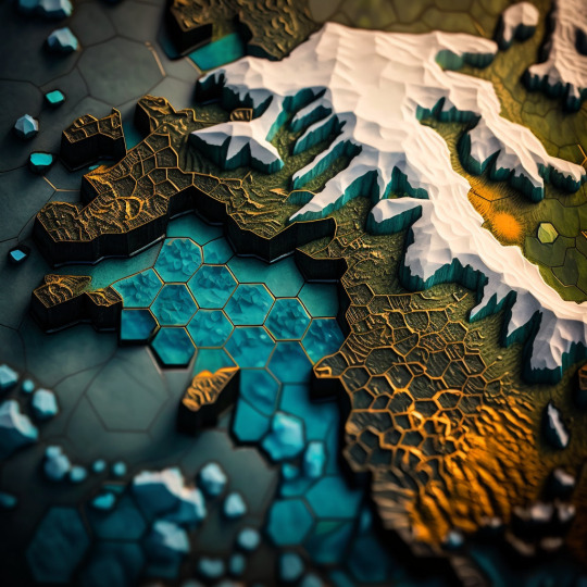
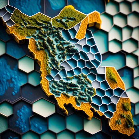
Floor Plans created using Bing Image Creator
#ai art#ai generated#ai art generator#ai artwork#Bing#bing ai#bing image creator#microsoft bing#floor plan#blue print#house layout#aerial map#home#house#decor#interior design#construction#build#sims 4#sims#sims4#ts4#the sims 4#minecraft
4 notes
·
View notes
Text
I've been really into IS3 since the update, and I really like the additions and changes, but some of the new stages feel very IS2, in that they're kind of just a check to make sure you have a ranged unit or a medic or something, and they feel weirdly out of place
#arknights#IS3 still kind of had some of those to begin with#like with how malody makes sure you have aoe or block count#but IS2 had a million poison or dp down or aerial unit maps#and easing up on those was imo a good idea#so it feels weird it being walked back a bit
16 notes
·
View notes
Text
Airship Port [84×111] by Czepeku Scenes

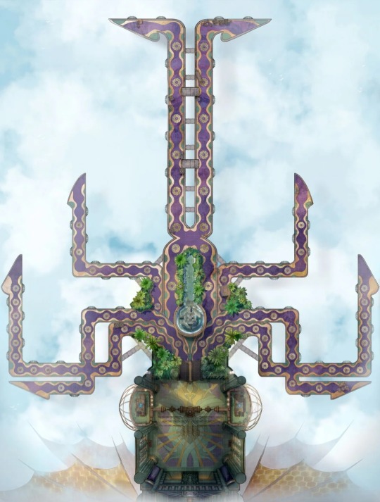
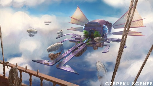
#czepeku#scenes#airship#airships#flying#flight#air#wind#aerial#vehicle#vehicles#port#ports#landing#dock#docks#map#maps#tech#steampunk#arcanepunk
13 notes
·
View notes


Text
We caught up on TYBW episodes last night! (And maybe, ever again, will also catch up on Tumblr!! HAHA)
While I probably have more thoughts, (apparently) the most pressing one is that I REFUSE TO BELIEVE THAT ANY SHINIGAMI WOULD IGNORE JAMES.
I do not think anyone--least of all anyone in 11th, famously merciless and even more famously led by a small, unassuming pink thing--would ignore him. I think they would kill him. They might make the mistake of preferring to sequentially fight Mask on-one-one (typical Gotei/honor nonsense), but boy I refuse to believe they wouldn't simply also go for the kill with James. Why wouldn't they? Their entire job is fighting weirdly-shaped things and these weirdly-shaped things just leveled their house *twice* don't @ me I do not actually want to talk about James
otoh Souou Zabimaru 🤩
#second blessing: THE MAP#during ep 4 my co-blogger was like 'omg we know where each sternritter is located barracks-wise and they just showed an aerial of those#colored powers. if we cared enough to match color to sternritter we could approximate the layout of soul society'#luckily there was an ACTUAL MAP WITH LABELS so no one neeeded to care enough about sternritter color-coding to do this the hard way lololol#AN ACTUAL MAP!!#bleach tybw
18 notes
·
View notes
Text
Adam Sills’s well-written and beautifully produced Against the Map is in some ways a strange book to review [...] [from the disciplinary perspective of environmental studies]. Sills shows little interest in environmental history or ecocriticism, even in the “ecology without nature” mode [...]. His basic argument is that cartography, because of print capitalism, seeped into all sorts of facets of life on the British Isles during the late seventeenth and eighteenth centuries. It became something that playwrights, novelists, and creative nonfiction types, like Samuel Johnson, developed spaces of resistance to in their publications. Sills highlights the political nature and problematic historical genealogies of maps, an argument that has broader implications for [contemporary] environmental historians who use maps to convey [relatively more “objective” and/or “scientific” information] [...].
Sills begins by accepting the idea, derived from Ben Anderson’s comparative work, that “the history of the map and the history of the modern nation state are inextricably bound up with each other” (p. 1). He then cites two of the key analysts of this in relation to Britain: Richard Helgerson on the literary nationalism of the English Renaissance and John Brewer on the fiscal-military state of the eighteenth century, with its army of surveyors and excise tax collectors. In this historiography, the “surveyor emerges as an authorial figure,” key to the making of the modern state as distinct from traditional dynastic and ecclesiastical authority (p. 3). Combined with cheap printing, the result was what Mary Pedley has called a “democratization of the map” (p. 4). [...]
---
For John Bunyan, the “neighborhood” became a site of resistance (as it is for Denis Wood in his 2010 Everything Sings: Maps for a Narrative Atlas). [...]
For Aphra Behn, [...] the theater and “built environment” of the “fragmented, chameleonlike ... scenic stage” had the ability to challenge coherent representations of the Atlantic empire produced by maps like those of world atlas publisher and road mapper John Ogilby (p. 65).
From Dublin, Jonathan Swift directly satirized the cartographic and statistical impulses of the likes of William Petty, Henry Pratt, and Herman Moll, who all helped visualize London’s colonial relationship with Ireland [...].
From London, Daniel Defoe questioned efforts to define what precisely makes a market or market town through maps and travel itineraries, pointing toward the entropic aspects of the market (“its inherent instabilities and elusive nature”) that challenged and escaped efforts to stabilize such spaces through representations in print (p. 163).
Johnson’s travels to Scotland redefined surveying, resisting the model put forward by the fiscal-military state in the aftermath of the Jacobite Rebellion of 1745.
---
The final chapter and conclusion, “The Neighborhood Revisited,” looks at Jane Austen’s Mansfield Park (1814), a classic novel of the artificial environment of the estate garden. By the early nineteenth century, neighborhoods were more like gated communities and symptomatic of Burkean conservatism and nostalgia. But in Austen’s hands, their structures of affect also suggest the limits of the controversial map- and data-centric literary methodologies [...] and perhaps more broadly the digital humanities. “The principle of spatial difference and differentiation, the heterotopic conceit, always remains a formal possibility, not only at the margins of the empire but at its very center as well,... a possibility that the map cannot acknowledge or register in any fashion” (p. 234). For Sills, this is true of eighteenth-century mapping as well as the fashion for “graphs, maps, and trees” in the early twenty-first century.
---
Sills’s basic argument, that a certain canonical strain of English literature - from Bunyan to Austen - positioned itself “against the map,” seems quite solid. He makes this point most directly by appealing to the work of Mary Poovey on the modern “fact,” with the map as “a rhetorical mode ... that serves to legitimate private and state interests by displacing and, ultimately, effacing the political, religious, and economic impact of those interests” (p. 91).
Nevertheless, returning to a[n] [exclusively] canonical, Bunyan-centered, “small is beautiful” neighborhood approach [potentially ignoring planetary environmental systems, the global context, in cartography] seems limited and problematic from the perspective of Anthropocene [...]. The global maps and mathematics used by the likes of Edmund Halley and Isaac Newton, which were directly satirized by Swift in the Laputa section of Gulliver’s Travels (1726), did something different than Petty’s mapping of Ireland. High-flying as they may have been, such maps and diagrams were key to the development of [...] environmental thinking by Charles Darwin, Charles Lyell, Alexander von Humboldt, and others in the nineteenth century. More recently, global mapping [...], like the internet closely tied initially to the modern American fiscal-military state, have [also later then] been essential to identifying processes of climate change, ocean acidification, deforestation, dead zones, sea level rise, desertification, and a host of other processes that would otherwise be challenging to perceive. This is no mere “Vanity Fair.” Sills’s book would have benefited from engaging with Jason Pearl’s Utopian Geographies and the Early English Novel, published in 2014 [...]. Pearl also does close readings of Behn, Defoe, and Swift, choosing Margaret Cavendish instead of Bunyan and stopping in 1730, just before things became picturesque but just after they were financialized by the South Sea Bubble, Newton’s mint, and Robert Walpole. Pearl reproduces maps by Defoe of Robinson Crusoe’s global travels and of Crusoe’s island, Swift of Houyhnhnmland, Ambrosius Holbein of Thomas More’s Utopia [...].
What if rather than “against the map,” we are seeing struggles between radical and conservative cartography [...] engaged in a fight over the future (utopia)?
What if what [...] [some have] called “capitalist realism” [...], what might in the eighteenth century be called “nationalist realism,” is not the only thing happening with maps and the imagination?
---
Text above by: Robert Batchelor. “Review of Sills, Adam, Against the Map: The Politics of Geography in Eighteenth-Century Britain.” H-Environment, H-Net Reviews. May 2023. Published online at: h-net,org/reviews/showrev,php?id:58887. [Bold emphasis and some paragraph breaks/contractions added by me. In this post, all italicized text within brackets added by me.]
#hmm lot going on here pretty thoughtprovoking for a review#i have lots of thoughts about radical potential of maps for conception of planetary scale and antiimperialism#though simultaneously must remain critical of panopticon aerial perspective of satellite imagery as batchelor says originating with usempire#to acknowledge radical alternatives to imperial mapping in nineteenth century#instead of namedropping humboldt and darwin and chauvinist racist figures i wouldve pointed to#exslaves and abolitionists and their use of global scale conceptions to frame revolutionary atlantic and international solidarity#anyway#abolition#ecology#colonial
18 notes
·
View notes
Text
has anyone seen/made a map of berk?
like the village/island? i cant figure out where anything is (the docks, gothis hut, gobbers shop, etc) but i dont think a map of berk specifically was made?
does anyone know?
#httyd#berk#i made a map of burgess (rotg) before#but that was using multiple bits of concept art#+ a ton of aerial shots of the town#berk has aerial shots but#its so cliffy i cant see anything??#help???
19 notes
·
View notes
Text
im shallowly and foolishly obsessed with gw2 because they hit my niche fantasy experience of getting to freely move around monstrously huge dragons while also having a smaller pet dragon you are bonded to that you can use to fly around it and maybe also land on it walk around on its back. they just let me do this and i went nuts for 3 unending months for reasons even i dont understand
#talks#guess what my favorite meta map is Its dragonfall. you got it right#and i remember when httyd 2 came out and i was bummed out by it because i was like the heart of httyd was not its big bombastic#star wars inspired aerial dragonfights occurring around much more massive giant dragon kaiju fights#but its different when its a video game#and that stuff gets to happen to MEEEEE :3#gw2 particularly so so good at sense of scale and wonder especially in overworld where you dont usually see spectacle on that level in#other MMOs i feel. because the maps are often designed to convey a narrative that progresses through recurring meta events#so you can have stuff so massive that it shakes the ground or like roars that fill the entire map or stuff exploding out of the ground#and altering the landscape right before your eyes
21 notes
·
View notes
Text
Unexpected CQL set update!
I'm sleuthing for some aerial data for my next architecture projects, Four Seasons Manor and the Unclean Realm, and look what I spotted!
You gotta admit, I was pretty damn close.
If you’re wondering why I’ve started searching for aerial shots as part of my set research now and not at the beginning of this series - first of all, I’m just winging it at all times. I had no idea what I was doing then, or even now.
Secondly, Four Seasons Manor is proving to be split across two sets, so the birdseye is going to need a little bit of creativity✨ with the help from source material.
Link to the full Hanshi set meta and print.
CQL Set Design series:
Part 1: The Jingshi
Part 3: Lotus Pier
#cql set design#cloud recesses#the untamed#the hanshi#nikkidraws#set design saga#gusu lan#hengdian world studios#hengdian#siji manor#siji shanzhuang#art update#technical drawing#birdseye view#aerial view#maps#cartography
15 notes
·
View notes
Text
While knowing fully-well that Bethedos would never make a Fallout game that takes place in New Jersey, if they did, would they include the AT&T Holmdel site? Would they remember to get rid of or change the water tower?
#sodalite speaks#the water tower is modeled after a transistor btw. if you care#but like looking at an aerial image of the damn thing. the roads are so silly it'd look great on a map
2 notes
·
View notes
Text
Here’s the aerial shot of Ocean Avenue from “The Plight Before Christmas” from a clip video on yt. Since so many people were tagging my map with reference I though y’all might like to see the screen cap it’s based on.
#bobs burgers#bob’s burgers#screen cap#13.10#for reference#since you writers out there seemed to like my map#I want the aerial shot from the movie!#if I can find it I’ll post it too#ocean avenue
5 notes
·
View notes
Text
i only have 4 maps left as catwoman before im alllll done with all the combat medals :D
then its onto everyone's predator maps (except nightwings--he's done)
#shitpost#im only working on the ranked medals and NOT campaigns#campaigns seem like they would be a real huge grind in some ways#i am up for considering them since i seem to be able to BUT#i will definitely take THEM slowly and am NOT thinking about them atm#as for predator#medals i have like. one map done on robin#so i have a lot of predator-ing to do haha#taking a break b/c catwoman is a little janky ive noticed??#her fuckin aerial attack is SO slow and also she can get HIT during it which is KILLING me#so i need a breather before i go back to the last 4 maps
3 notes
·
View notes
Text
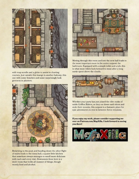
Griffon Rider's Outpost [25×60] by MapZilla
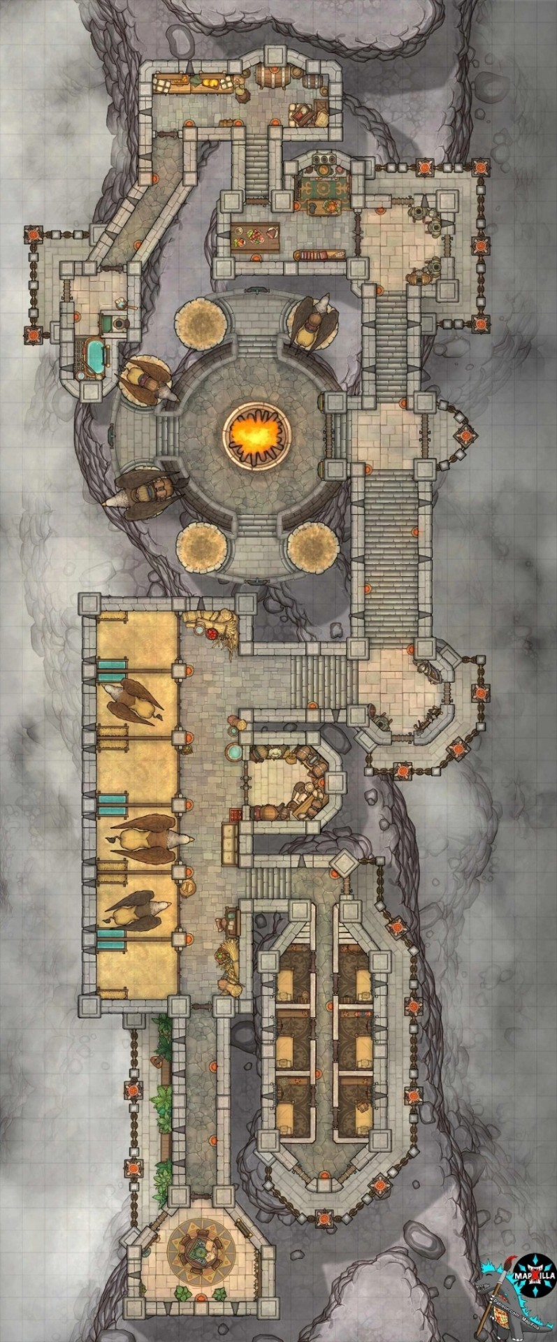


46 notes
·
View notes
Text


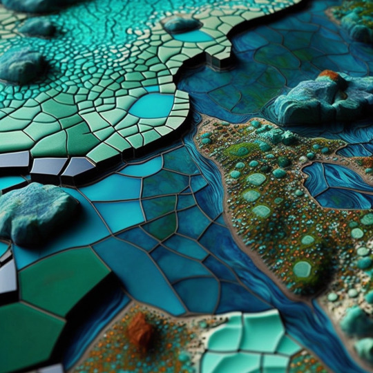
Mosaic Maps
3 notes
·
View notes
Text
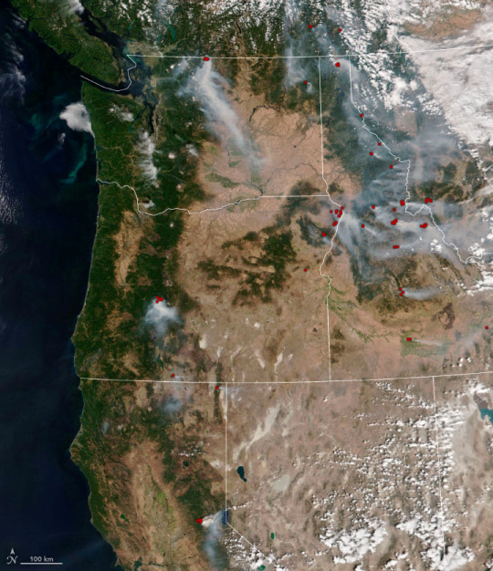
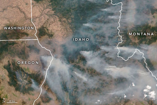
Smoky Fires Rage in the Northwest, Posted 12 September 2022
"The scorching weather of summer 2022 has left much of the Northwestern United States primed to burn with wildland fire. In early September, the northern Rocky Mountains and the Cascade Range billowed with smoke that was slowly wafting across the continental U.S. and southern Canada.
According to the National Interagency Fire Center (NIFC) on September 9, at least 96 large fires were burning on 690,000 acres (2800 square kilometers) in eight states. Many of the fires were clustered in the Northern Rockies, the Great Basin, and the Pacific Northwest, with 37 burning in Idaho, 22 in Montana, 12 apiece in Oregon and Washington, and 10 in California.
The images above and below were acquired by the Visible Infrared Imaging Radiometer Suite (VIIRS) on the NOAA-20 satellite on September 8, 2022. Red pixels indicate areas where VIIRS thermal bands detected high temperatures indicative of fire.
Just northwest of Salmon, Idaho, the Moose Fire has burned more than 125,000 acres (500 square kilometers) since it ignited on July 17, 2022. The blaze was 33 percent contained on September 9 and not expected to be fully contained until the end of October. Inciweb reported that the fire was caused by human activity, by far the predominant cause of wildland fire in the United States.
In northeastern Oregon, the Double Creek Fire has burned more than 101,000 acres (400 square kilometers) since lightning ignited it on August 30. The fire was 15 percent contained and not expected to be fully contained until the end of October. The Cedar Creek Fire in Willamette National Forest had been burning since August 1 and consumed 33,000 acres.
“Strong winds will continue in parts of Oregon, Washington, and California. Dry thunderstorms are possible in California and the north central Sierras today,” NIFC reported on September 9. “Excessive heat warnings remain in effect for much of California and Oregon. A fuels and fire behavior advisory has been issued for northern California due to dry fuels and the potential for extreme fire behavior with the hot, dry, and windy weather pattern.”
Source: NASA Earth Observatory
6 notes
·
View notes
Photo
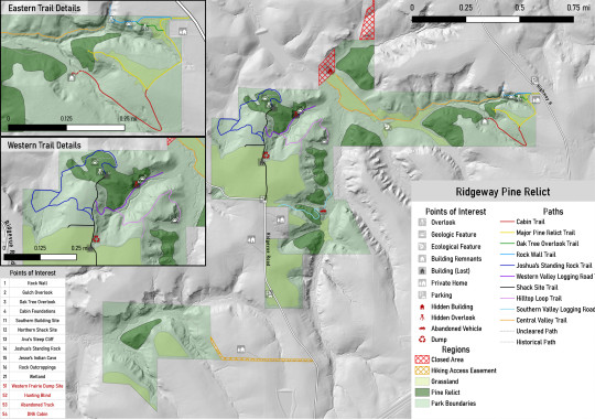
it was only a hike
how did it come to this
(the answer is lidar data and an obsession with mapping things)
#to be clear this is my attempt to make an updated map for a local state natural area#the current one is missing pretty much every trail on the western side and has very crude representations of everything else#this one is based on many hikes aerial photography lidar data and official plat maps for boundaries#I even beat the DNR map for pine relict accuracy because one they marked isn't actually on park property#the forested area today that is on park land was clearcut in the early 1900s and doesn't have any old pines left#personal#but feel free to reblog
2 notes
·
View notes
Last Seen Blogs

inamsawan
Untitled

caribbeanboy1
Badgang🎮

realghostbustersgifs
Real Ghostbusters Gifs!

gyorgykorossy
György Kőrössy

medicaltaxighana
MEDICAL TAXI GHANA