#dasht-e kavir
Note
How did Erik adjust to living in the desert?
Presumably you're talking about when he lived in Persia (Qajar Dynasty Iran) He lived in Mazandaran which isn't a desert at all, it's a coastal province on Iran's northern border on the Caspian sea. Geographically it's a coastal plain and mountains, there are lots of dense forests and green valleys.
There are only two proper desert regions in Iran, Dasht-e Kavir being the one closest to Mazandaran and Tehran, which is the capital just south of Mazandaran and a place Erik would likely have visited often and not likely Erik would have spent much, if any time in the actual desert.
18 notes
·
View notes
Text

Dasht-e Kavir is a large desert in the middle of the Iranian Plateau. Spanning roughly 30,000 square miles (77,600 square kilometers), the so-called “Great Salt Desert” has recorded temperatures up to 122°F (50°C). This heat causes extreme vaporization that turns marshes and mud grounds into swirling crusts of salt, like those featured in this Overview.
34.797689°, 54.728858°
Source imagery: Planet
247 notes
·
View notes
Text

Dasht-e Kavir, Iran
Instagram: janritter10
#goals#ich liebe dich#happy#couple goals#love#feelings#tumblr#hot#amazing#world#smile#life#beautiful#picture#my photos#photooftheday#photography#mine#me#instagram#like#travel#journey#girl#desert#nice#sunset#miss you
100 notes
·
View notes
Text
#architecture#design#interiordesign#amazingarchitecture#architect#archilovers#luxury#photooftheday#travel#architecturephotography#ai
7 notes
·
View notes
Text

Great Salt Desert, Iran
The Dasht-e Kavir (دشت كوير), or Great Salt Desert, is the largest desert in Iran. It is primarily uninhabited wasteland, composed of mud and salt marshes covered with crusts of salt that protect the meager moisture from completely evaporating.
This image was taken by the Landsat 7 satellite on October 24, 2000. It is a false-color composite image made using infrared, green and red wavelengths. The image has also been sharpened using the sensor’s panchromatic band.
⤷ Image provided by the U.S. Geological Survey EROS Data Center Satellite Systems Branch. Caption adapted from text originally provided by NASA’s Earth Observatory.
Source: NASA/USGS Landsat 7; NASA Earth Observatory. 🪐🌟
2 notes
·
View notes
Photo

🔥 Dasht-e Kavir (a/k/a The Great Salt Desert), Iran; located about 300 kilometers east of Tehran. Runoff from the surrounding mountains creates seasonal lakes and marshes. High temperatures cause the water to evaporate, leaving behind clays and sand soils with a high concentration of minerals.
1 note
·
View note
Photo

Dasht-e Kavir (Iran, October 2000).
Also known as the Great Salt Desert, the Dasht-e Kavir is the largest desert in Iran. It is mostly uninhabited wasteland, made up of mud and salt marshes covered with salt crusts that protect the meagre moisture from completely evaporating.
26 notes
·
View notes
Photo
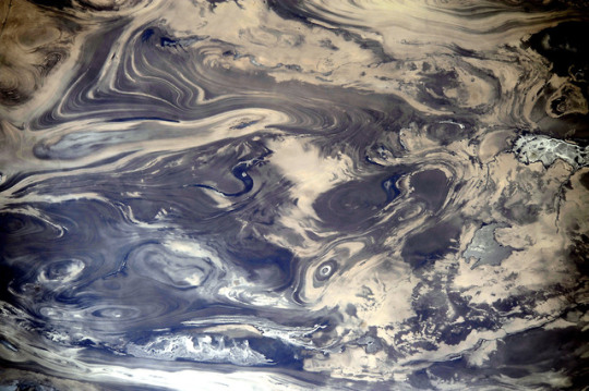
The Dasht-e Kevir
One does not typically think of deserts in aesthetically pleasing notions. Yet this image of the Great Salt Desert in Iran, which was captured by astronauts on the International Space Station, makes a barren wasteland look like an abstract painting, with lines and curves intersecting and bisecting each other in seemingly fractal patterns.
Also known as Dasht-e Kavir (literally translated from Persian as “desert of salt-marsh”), this vast desert stretches across the Iranian Plateau with an area of about 77,600 km2. As hinted by its name, Dasht-e Kavir has a wealth of salt domes, which were formed from evaporation of an ancient ocean that had once covered the landscape. Because salt is relatively less dense than most rocks, its burial by any new rock can be short-lived as the salt can press against the overlying weight, forming domes. Wind, rain, and other physical processes can erode away at the salt domes, cutting away through cross-sections and exposing the complex layering visible in the image.
Of course, like any desert, its climate is one of extremes. The dry heat of Dasht-e Kavir often alternates with severe storms that shape the desert’s salt marshes through intense cycles of evaporation, inundation, and erosion. Much of the landscape is uninhabitable due to the harsh environment, making it a pristine hinterland perfect for desert and salt dome research.
-DC
References and further reading https://earthobservatory.nasa.gov/images/83438/kavir-desert-iran https://www.universetoday.com/110872/believe-it-or-not-this-is-stunning-blue-landscape-is-a-desert-as-seen-from-space/amp/
Photo Credit: NASA Earth Observatory
108 notes
·
View notes
Photo


Of Moon and Sun
#Naein#Ardestan#Isfahan#Iran#Dasht-e Kavir#Pirnia House#Pirnia Ethnology Museum#شمسه#Iranian art#ceiling#moon#sun
4 notes
·
View notes
Photo

(via Dust in the Dasht-e Kavir : Image of the Day)
4 notes
·
View notes
Quote
There is a way to master silence, control its curves, inhabit its dark corners, and listen to the hiss of time outside.
Paul Bowles on the Dasht-e Kavir
6 notes
·
View notes
Video
youtube
The Mystical Paradise - Documentary - [Trailer]
The Mystical Paradise - The beautiful deserts of Iran. This uniq documentary shows the tourism areas of Dashte Lut and Dashte Kavir deserts of Iran.
https://vimeo.com/ondemand/themysticalparadise
☝️Rent & watch the full video in the top link! ☝️
The Mystical Paradise (Iran, 2018, 55 mins.)
Helishots with poetic narrative has turned this documentary to a dreamy film. Vast plains, sand hills, ponds and migratory birds, palm trees, camels and caravansaries, villages and monuments, and the tourist who have traveled to these areas are the beautiful landscapes of this film.
Scriptwriter: Mahboobeh Tabaie Aqdaie
Directed by: Ali Jahani, Javad Daneshvar
Production Company: Javada Film https://javadafilm.com
1 note
·
View note
Text

Dasht-e Kavir is a large desert in the middle of the Iranian Plateau. Spanning roughly 30,000 square miles (77,600 square kilometers), temperatures in the “Great Salt Desert” can soar up to 122°F (50°C), causing extreme vaporization that turns marshes and mud grounds into swirling crusts of salt, as seen in this segment of the desert here.
See more here: https://bit.ly/3JZmiNg
34.797689°, 54.728858°
Source imagery: Maxar
795 notes
·
View notes
Text
Consider, if you would:
NSA: nerds
FBI: Jocks
CIA: Theatre kids
#food for thought#if the nsa has to deal with all my random facts i look up#then obviously they gotta be nerds as well#nsa#fbi#cia#that was as far as i got for the moment#im sure if you give me a few minutes ill think of more#this came about because i had to research the dasht-e kavir and what the closest cities were#and what algeria military use as their weapons#and then i promptly turned around and researched outlast because reasons?
0 notes
Text
Aujourd'hui est apparue la carte de vingt ans de parcours d'un aigle. Il a survolé quinze pays, de sa naissance en Russie à sa mort en Arabie Saoudite, en passant par l'Iran et l'Éthiopie. Pensée toute bête mais intense : il n'y a pas vu des pays mais des paysages. Les Carpates, la Caspienne, le Dasht-e Kavir, le Canal de Suez.
Voler, oui d'accord. Mais c'est ça aussi être un oiseau : ne pas mettre de noms sur les territoires.
3 notes
·
View notes

Last Seen Blogs

stuartchase
Untitled

birdcomics-blog
The Bird Comics

chuzde
Unlimited Free Hosting at GoogieHost

studies-overseas
Study Abroad

10minutemadrasah
10 Minute Madrasah