#digital mapping technology
Explore tagged Tumblr posts
Visit Tumblr Blog
Explore Tumblr blogs with no restrictions, modern design and the best experience.
Last Seen Tumblr Blogs


Fun Fact
25% of US internet users with an annual income of $80-100K use Tumblr.
Text

8 notes
·
View notes
Text
Hi all.
I am a 25 year old student nurse and nature devotee who has an interest in memory benches.
With no valuable IT skills, a limited budget and no overall knowledge of creating and maintaining an active online map, I am seeking advice, tips and potentially assistance from those of you who have insight on how to achieve my goal.
In the UK, memory benches are everywhere - wooden or steel seats of engraved love given by those who were privileged enough to have shared life with those who have passed.
I made this tumblr so that I can start keeping a record of the memory benches I come across in my city, Sheffield, tagged here on this account by location, postcode and the dedicatee’s given name. I will record benches I find outside of Sheffield also, just far less frequently or sporadically.
My goal is to eventually pool the knowledge and resources together to, first, create an online directory of recorded memory benches and then hopefully develop into a map once I gain experienced of how to do so.
A like or reblog would be appreciated if you see this, and any and all insight into the matter would be appreciated.
Cheers for reading! Ask box is open or you can email me at [email protected].
#Project#Project help#IT#Benches#Memory benches#Nature#Advice#Community project#Help#Help needed#Technology#Sheffield#Yorkshire#London#IT help#Maps#Map#Interactive map#Digital map#Preservation#Tumblr staff#Staff
6 notes
·
View notes
Text
11/3/25 Week 3
This week so far I've fleshed out my concept a lot more. I'm still doing AI, but rather than a 'guys ai has problems y'all need to get real' angle I might go in an educational angle to help artists use ai more responsibly. Focusing on making sure your ai ONLY uses your input, to avoid the ethical issues with existing publicly available AIs. Issues with this topic are that I'm being hypocritical when it comes to the environmental concerns, but I'll have to do more research about where the emissions are coming from, which is likely the volume of requests for public AIs, which maybe wouldn't apply to mine? As for the media products, I'm leaning towards doing photocomposition, just with using AI alongside the art I make to train it. This is potentially a realistic idea for me, since I have a decently big back catalogue (of varying quality...).

(Mind-map I made today, two general directions were explored plus a few offshoot ideas.)
#fyp#tumblr fyp#fypツ#foryou#fypage#fypシ#fyp tumblr#my fyp#design#artificial intelligence#technology#education#ai sexy#mind map#brainstorming#art#digital art#art study#media#social issues#wait you guys I'm actually lowkey BRAINY ASF likeeeeee#also I'm putting these tags here as a joke im STAYING HUMBLE#im probably not even going to post the final products bc they'll just get scraped... sooo.... have fun reading the rambling my 1m viewers
5 notes
·
View notes
Text

Always know your true north.
7 notes
·
View notes
Text

#green 3d world map#technology background#creative 3d world map#world map background#digital art#world map concepts#wallpapers
0 notes
Text
Propickle revolutionizes property exploration with its advanced 3D mapping platform for real estate. From virtual site walkthroughs to detailed spatial insights, it empowers buyers and developers to visualize projects like never before—anytime, anywhere.
#interactive 3D mapping services for real estate#3D visualization solutions for property developers#virtual site tours for real estate projects#digital twin technology for real estate#web-based 3D walkthroughs for real estate#gamified property exploration tools#interactive location mapping for real estate#3D solutions for real estate experience
0 notes
Text
#HR Technology Trends#Generative AI in HR#Sentiment Analysis#Emotional AI#Skills Ontology#Dynamic Talent Mapping#HR Digital Transformation#Future of Work
0 notes
Text

The Importance of Land Acquisition and Monitoring for Sustainable Development
Land acquisition and monitoring play a crucial role in shaping sustainable development by ensuring that land resources are used efficiently, equitably, and responsibly. Whether for infrastructure development, urban expansion, or agricultural projects, these processes must align with environmental and social goals. As the demand for land increases, the use of advanced tools like land management software, GIS-based land management systems, and land asset management software has become critical for driving sustainable outcomes.
#Land acquisition#Land acquisition process#Sustainable development#Land monitoring#Sustainable land management#Land management system#cyberswift#GIS-based land management#Land use planning#Environmental sustainability#Land records management#Land survey and mapping#Land asset management#Digital land monitoring#victoryofgoodoverevil#Sustainable land practices#Regulatory compliance in land acquisition#Role of technology in land monitoring#land management software#land management solutions#land asset management software#land management system#land acquisition software#land management system software#Land software#Land Allotment Software#Land Information management System#GIS based land management System#GIS based land records management#Land Records Management System
0 notes
Text
Digital Map Market Size, Share, Growth | Industry Analysis
The digital map market was valued at $21.8 billion in 2022, and is estimated to reach $89.1 billion by 2032, growing at a CAGR of 15.4% from 2023 to 2032.
Download Sample Report: https://www.alliedmarketresearch.com/request-sample/2735
More Insights: https://www.alliedmarketresearch.com/digital-map-market
#Digital Map Market#Digital Map Industry#Digital Map#Digital Map Market Size#Digital Map Market Share#Digital Map Market Forecast#Digital Map Market growth#Digital Map Market Demand#Technology
0 notes
Text
Uncover Growth Opportunities with 1Lattice Tech Market Research

1Lattice helps technology and software companies grow through better product-market fit, improved competitive positioning, and increased customer loyalty. With our proven methods, your business can thrive in today's dynamic market landscape. Let 1Lattice be your partner in achieving sustainable tech growth and enduring success. Stay ahead with the latest tech landscape. Join us at 1Lattice, as we explore the forefront of innovation and navigate the exciting possibilities of the digital frontier.
#tech market research#technology research company#technology research services#market research technology#digital maturity assessment#customer journey mapping#mapping digital journey
1 note
·
View note
Text
Point Cloud to BIM: The Ultimate Guide for AEC Professionals

In the realm of architecture, engineering, and construction (AEC), the adoption of innovative technologies has revolutionized traditional processes. One such advancement is integrating Point Cloud data into Building Information Modeling (BIM) workflows.
Scan to BIM, also known as Point Cloud to Building Information Modeling (BIM) is a process used in the AEC industry to convert point cloud data captured from laser scanners or other reality capture methods into digital BIM models.
This fusion offers unprecedented levels of accuracy, efficiency, and detail, driving significant advancements in project planning, design, and construction phases.
In this comprehensive guide, we delve into the intricacies of Point Cloud to BIM, exploring its definition, Integration, software, application, benefits, challenges, and implementation strategies.
To get more insights - https://prototechsolutions.com/blog/point-cloud-to-bim-the-ultimate-guide-for-aec-professionals/
#point cloud to bim#scan to bim#point cloud#bim#laser scanning#reality capture#architecture#engineering#construction#civil engineering#surveying#drone#virtualreality#lidar#revit#digital twin#technology#mapping
0 notes
Text
Network Survey Vehicles: Rolling Data Hubs or Covert Spies on Our Connectivity
In the age of seamless connectivity and the relentless pursuit of technological advancements, the role of Network Survey Vehicles has come under scrutiny. These mobile units, equipped with sophisticated equipment for mapping and analyzing communication networks, are hailed as essential tools for improving connectivity infrastructure. However, recent allegations have surfaced, questioning whether these vehicles are acting as benign data hubs or potentially covert spies on our digital lives. In this blog, we delve into the world of Network Survey Vehicles to unravel the controversy surrounding their dual identity.
Visit on us :https://intellitest.co.in/
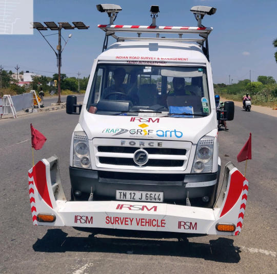
#Visit on us :https://intellitest.co.in/#In the age of seamless connectivity and the relentless pursuit of technological advancements#the role of Network Survey Vehicles has come under scrutiny. These mobile units#equipped with sophisticated equipment for mapping and analyzing communication networks#are hailed as essential tools for improving connectivity infrastructure. However#recent allegations have surfaced#questioning whether these vehicles are acting as benign data hubs or potentially covert spies on our digital lives. In this blog#we delve into the world of Network Survey Vehicles to unravel the controversy surrounding their dual identity.
0 notes
Text
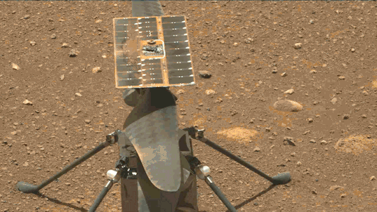
What We Learned from Flying a Helicopter on Mars

The Ingenuity Mars Helicopter made history – not only as the first aircraft to perform powered, controlled flight on another world – but also for exceeding expectations, pushing the limits, and setting the stage for future NASA aerial exploration of other worlds.
Built as a technology demonstration designed to perform up to five experimental test flights over 30 days, Ingenuity performed flight operations from the Martian surface for almost three years. The helicopter ended its mission on Jan. 25, 2024, after sustaining damage to its rotor blades during its 72nd flight.
So, what did we learn from this small but mighty helicopter?
We can fly rotorcraft in the thin atmosphere of other planets.
Ingenuity proved that powered, controlled flight is possible on other worlds when it took to the Martian skies for the first time on April 19, 2021.
Flying on planets like Mars is no easy feat: The Red Planet has a significantly lower gravity – one-third that of Earth’s – and an extremely thin atmosphere, with only 1% the pressure at the surface compared to our planet. This means there are relatively few air molecules with which Ingenuity’s two 4-foot-wide (1.2-meter-wide) rotor blades can interact to achieve flight.
Ingenuity performed several flights dedicated to understanding key aerodynamic effects and how they interact with the structure and control system of the helicopter, providing us with a treasure-trove of data on how aircraft fly in the Martian atmosphere.
Now, we can use this knowledge to directly improve performance and reduce risk on future planetary aerial vehicles.

Creative solutions and “ingenuity” kept the helicopter flying longer than expected.
Over an extended mission that lasted for almost 1,000 Martian days (more than 33 times longer than originally planned), Ingenuity was upgraded with the ability to autonomously choose landing sites in treacherous terrain, dealt with a dead sensor, dusted itself off after dust storms, operated from 48 different airfields, performed three emergency landings, and survived a frigid Martian winter.
Fun fact: To keep costs low, the helicopter contained many off-the-shelf-commercial parts from the smartphone industry - parts that had never been tested in deep space. Those parts also surpassed expectations, proving durable throughout Ingenuity’s extended mission, and can inform future budget-conscious hardware solutions.

There is value in adding an aerial dimension to interplanetary surface missions.
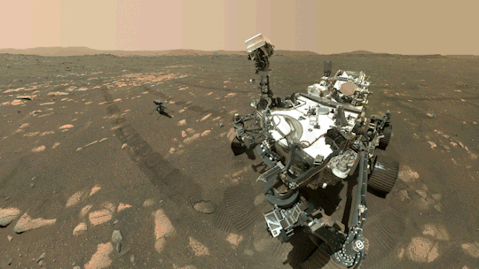
Ingenuity traveled to Mars on the belly of the Perseverance rover, which served as the communications relay for Ingenuity and, therefore, was its constant companion. The helicopter also proved itself a helpful scout to the rover.
After its initial five flights in 2021, Ingenuity transitioned to an “operations demonstration,” serving as Perseverance’s eyes in the sky as it scouted science targets, potential rover routes, and inaccessible features, while also capturing stereo images for digital elevation maps.
Airborne assets like Ingenuity unlock a new dimension of exploration on Mars that we did not yet have – providing more pixels per meter of resolution for imaging than an orbiter and exploring locations a rover cannot reach.
Tech demos can pay off big time.
Ingenuity was flown as a technology demonstration payload on the Mars 2020 mission, and was a high risk, high reward, low-cost endeavor that paid off big. The data collected by the helicopter will be analyzed for years to come and will benefit future Mars and other planetary missions.
Just as the Sojourner rover led to the MER-class (Spirit and Opportunity) rovers, and the MSL-class (Curiosity and Perseverance) rovers, the team believes Ingenuity’s success will lead to future fleets of aircraft at Mars.
In general, NASA’s Technology Demonstration Missions test and advance new technologies, and then transition those capabilities to NASA missions, industry, and other government agencies. Chosen technologies are thoroughly ground- and flight-tested in relevant operating environments — reducing risks to future flight missions, gaining operational heritage and continuing NASA’s long history as a technological leader.
youtube
You can fall in love with robots on another planet.
Following in the tracks of beloved Martian rovers, the Ingenuity Mars Helicopter built up a worldwide fanbase. The Ingenuity team and public awaited every single flight with anticipation, awe, humor, and hope.
Check out #ThanksIngenuity on social media to see what’s been said about the helicopter’s accomplishments.
youtube
Learn more about Ingenuity’s accomplishments here. And make sure to follow us on Tumblr for your regular dose of space!
5K notes
·
View notes
Text
Detroit Tech Access Hubs Map
I’ve added the term “access” to the City of Detroit’s listing of “tech hubs” since that seems to be a term with a wide and varied definition. In this case the City is talking about: […] free wifi, devices, and basic digital literacy training The sites range from support from major telecom companies like Comcast and ATT to the Connect313 efforts. Previous researchers have also included a broader…
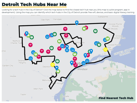
View On WordPress
#AT&T#City of Detroit#Comcast#Detroit#geography#internet#map#Office of Digital Inclusion#tech hub#technology
0 notes
Text

#4k#blue neon world map#technology background#background with world map#blue world map#blue neon light#digital technology#world map concepts#wallpapers
0 notes
Text
Propickle is a cutting-edge 3D mapping platform for real estate that transforms the way properties are showcased and experienced. From interactive site tours to hyper-realistic floor plans and project visualizations, Propickle empowers developers and brokers with immersive tools that engage buyers and drive informed decisions—anytime, anywhere.
#interactive 3D mapping services for real estate#3D mapping platform for real estate#3D visualization solutions for property developers#virtual site tours for real estate projects#digital twin technology for real estate#3D solutions for real estate experience#web-based 3D walkthroughs for real estate#real estate experience with interactive 3D visuals#gamified property exploration tools#interactive location mapping for real estate
0 notes