#geographic information system(gis)
Explore tagged Tumblr posts
Visit Tumblr Blog
Explore Tumblr blogs with no restrictions, modern design and the best experience.
Last Seen Tumblr Blogs


Fun Fact
The Tumblr app for Google Glass was released on May 16, 2013.
Text
Reading papers and stumbled upon a

#Geographic information systems (GIS) and entomological research: A review#from 2010#how many other people has it tripped up#i say things#thesis posting
917 notes
·
View notes
Text
Are any of my mutuals scientists who are ALSO good with kids?
Last night I ran a booth with my university's geoscience club at an elementary STEM night, and the kids were... less than impressed with my setup.

I thought the fluffy cloud diorama and bigfoot sightings map would be interesting to kids, but I guess not.
The question is, how in the world do you get kids interested in the world of climate science and GIS?? How can I make my booth more fun for the next event (ideally on a budget 😬)?
#geoscience#climate science#geographic information systems#gis#stem#i feel so old. what are the kids into these days
10 notes
·
View notes
Text
if anybody has a pdf of this book:
H.D.G. MASCHNER (ed.), New Methods, Old Problems: Geographic Information Systems in Modern Archaeological Research, 1996, Center for Archaeological Investigations, Occasional Paper, n. 23, Carbondale, Southern Illinois University
i would really appreciate if you could share with me.. i need to read the second chapter but the book wasn't on annas archive, can you believe it...
#gis#qgis#New Methods Old Problems: Geographic Information Systems in Modern Archaeological Research#looking for a book#book request#media request#piracy#looking for books#fuck copyright#digital archaeology#moje
2 notes
·
View notes
Text
finally continuing to watch fantasy high because god hates me and the data i need for my GIS final is taking Forever to load
the file is so upsettingly large that it takes a minute to load anytime i try to do Anything
i'm trying to make it Smaller :(
15 notes
·
View notes
Text
GIS In Our Daily Lives
The involvement of Geographic Information Systems (GIS) in our daily lives is pervasive, influencing and enhancing various aspects across different sectors. The integration of GIS into everyday activities has become integral for decision-making, planning, and optimizing resources. GIS helps city planners and transportation experts to provide them with information like maps, satellite pictures, population statistics, and infrastructure data. GIS helps them make better decisions when designing cities and transportation systems that are sustainable and good for the environment.
The following points elucidate the notable involvement of GIS in our daily lives:
Navigation and Location Services: GIS provides monitoring functions through the visual display of spatial data and precise geographical positioning of monitored vehicles, whereas GPS provides accurate, clear, and precise information on the position and navigation of a monitored or tracked vehicle in real-time and at the exact location.GIS is at the core of navigation applications and location-based services on smartphones. It enables accurate mapping, real-time navigation, and geolocation services, assisting individuals in finding locations, planning routes, and navigating unfamiliar areas.
E-Commerce and Delivery Services: GIS software is a powerful tool for supply chain network planning. It helps determine the optimal location for distribution centers, warehouses, or other supply facilities. GIS is utilized in logistics and delivery services for optimizing routes, tracking shipments, and ensuring timely deliveries. E-commerce platforms leverage GIS to enhance the efficiency of their supply chain and last-mile delivery processes.
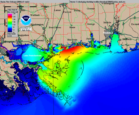
Weather Forecasting and Disaster Management: Many states are using GIS dashboard to monitor the rainfall across the state, on a real-time basis, from the data shared by rain sensors installed at various locationsGIS plays a crucial role in weather forecasting and disaster management. It assists meteorologists in analyzing spatial data, predicting weather patterns, and facilitating timely responses to natural disasters by mapping affected areas and coordinating emergency services.
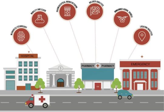
Healthcare Planning and Disease Monitoring: Geographic Information Systems enable the visualization and monitoring of infectious diseases. Additionally GIS records and displays the necessary information that health care needs of the community as well as the available resources and materials. GIS supports public health initiatives by mapping the spread of diseases, analyzing healthcare resource distribution, and assisting in the planning of vaccination campaigns. It aids in identifying high-risk areas and optimizing healthcare service delivery.
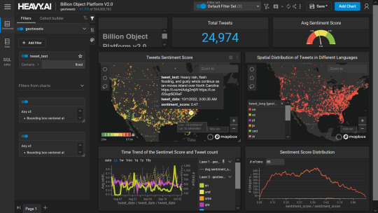
Social Media and Geo-tagging: GIS also helps in geotagging and other location related information in posts, it’s tools can map and visualize the spatial distribution of social media activity. This analysis can reveal trends, hotspots, and patterns in user engagement across different geographic areas. Many social media platforms incorporate GIS for geo-tagging, allowing users to share their location and experiences. This feature enhances social connectivity and facilitates the sharing of location-specific information.
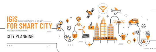
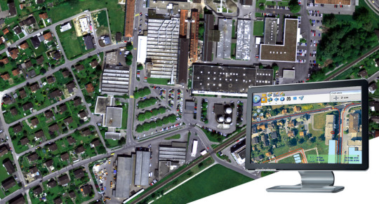
Smart City Initiatives: The Geographic Information System (GIS) offers advanced and user-friendly capabilities for Smart City projects and allows to capture, store and manipulate, analyze and visualize spatially referenced data. It is used for spatial analysis and modeling. It is the cornerstone of smart city planning, enabling the integration of data for efficient urban management. It supports initiatives related to traffic management, waste disposal, energy consumption, and overall infrastructure development.
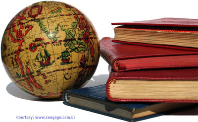
Education and Research: GIS is increasingly utilized in education and research for visualizing and analyzing spatial data. It enables students and researchers to explore geographic relationships, conduct field studies, and enhance their understanding of various subjects.
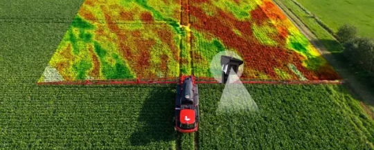
Agricultural Management and Precision Farming: Farmers leverage GIS to optimize agricultural practices by analyzing soil conditions, crop health, and weather patterns. Precision farming techniques, facilitated by GIS, contribute to increased crop yields and sustainable farming practices.
Real Estate and Property Management: In the real estate sector, GIS aids in property mapping, land valuation, and site selection. It provides real estate professionals with valuable insights into spatial relationships, market trends, and optimal development opportunities.
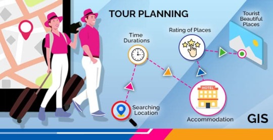
Tourism and Recreation: GIS enhances the tourism industry by providing interactive maps, route planning, and location-based information. It assists tourists in exploring destinations, finding attractions, and navigating efficiently.
The broad and varied involvement of GIS in our daily lives underscores its significance as a technology that not only facilitates geographic data analysis but also contributes to the efficiency, safety, and interconnectedness of modern society. As GIS applications continue to evolve, their impact on daily activities is expected to further expand and refine.
#gis#architectdesign#architecture#city#education#geographic information system(gis)#geographical indication
14 notes
·
View notes
Text
2 notes
·
View notes
Text
i have finally made a good decision. i am going to get a gis certificate but probably not until next fall cause i wanna do another semester of polish and ive seen the schedule of classes and it interferes with my polish class unfortunately. grad school for linguistics will be shelved for another year. i also am not confident i would get in with my gpa and the thought of having to write a thesis scares me.
#gis is geographic information systems#its like mapping data and using that data make plans#at least i think it is#anyways i need a job to pay for that shit lol#at least the first class you have to take by itself and its only 2 credit hrs so i dont expect that first class to cost too much#and i have time until then#and i could also change my mind by next fall#at least i have money for polish next semester so long as i get a job like soon lol#i keep saying that#but this time fr#like fr fr fr#i now have close to no savings after paying off something i forgot about :(#thats my own issue i guess#anywaysssss#continues applying to retail jobs very cutely while i wait for government jobs to get back to me#apparently those take months to hire and i want one so desperately i do not want a tech industry job
5 notes
·
View notes
Text
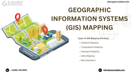
Geographic Information Systems (GIS) mapping services stand as the cornerstone of modern spatial analysis, bridging the gap between geographical data and informed decision-making. This dynamic technology seamlessly integrates diverse datasets onto a unified platform, yielding a comprehensive view of our surroundings. Within this realm, Gsource Technologies emerges as a leading force, offering a suite of GIS services that encompass a wide spectrum of applications.
From cadastral mapping, which aids in land administration and property management, to topographical mapping that captures the intricacies of terrain, Gsource Technologies' GIS expertise is all-encompassing. Their proficiency extends to parcel mapping, facilitating accurate delineation of property boundaries for effective land use planning.
With an eye on technological advancement, Gsource Technologies excels in map digitization, transforming paper-based maps into dynamic, interactive digital formats. Geological mapping, another specialized service, enables the identification and visualization of geological features, crucial for resource exploration and environmental studies.
Gsource Technologies' commitment to GIS services empowers urban planners to craft sustainable cities through spatial analysis, conservationists to safeguard ecosystems, and businesses to make data-driven decisions for growth. Moreover, their involvement in cadastral, topographical, parcel, map digitization, and geological mapping underscores their comprehensive approach to spatial data analysis.
In essence, GIS mapping services, coupled with Gsource Technologies' proficiency, reshape the way we perceive, analyse, and leverage geographical data. This synergy cultivates smarter urban development, environmental stewardship, and informed business strategies, ensuring a more sustainable and interconnected future.
#gsourcetechnolgies#engineeringservices#architecturedesignservices#GIS#geographic information system#cadastral#mapdigitization#architecturedesigns
3 notes
·
View notes
Text
7 Ways Telecom GIS Transforms Network Planning and Design
Geographic Information Systems (GIS) have become integral to the telecommunications industry, enabling operators to plan, design, build, and manage networks at scale. From strategic site selection to predictive demand modelling, GIS provides the spatial intelligence telecom providers need to accelerate deployment, reduce costs, and enhance service quality.
0 notes
Text
Ya'll I need a laptop good for writing, so nice keyboard and not a loud fan, AND have enough RAM to support arcgis/other GIS software. I was thinking about a thinkpad but not sure???
#lenovo#thinkpad#gis#environmental science#geographic information systems#geospatial analytics#writing#novelists#writing advice
0 notes
Text
Predict Profit Margins with Esri's GIS Software

Discover how Esri’s ArcGIS software empowers businesses to forecast profit margins and optimize operations before project launch. Learn how location intelligence and data-driven insights from GIS technology can improve decision-making and enhance company performance.
Read More: Predict Profit with Esri's GIS Software
0 notes
Text
Geographic Information System (Gis)
Utilize a Geographic Information System (GIS) to manage, analyze, and visualize spatial data effectively.
0 notes
Text
Interplay of Language & Sci-Tech: Exploring the Dravidian Languages
Interplay of Language & Sci-Tech: Exploring the Dravidian Languages @neosciencehub #SciTech #DravidianLanguages #Sciencenews #neosciencehub
The study of languages, particularly those with deep historical roots like the Dravidian languages, offers a unique vantage point from which to view the convergence of language, science, and technology. This article explores the various intersections where the Dravidian languages not only inform scientific inquiry and technological development but also benefit from them. It aims to provide a…
#AI#Digital media#featured#Geographic Information Systems (GIS)#Natural Language Processing (NLP)#sci-tech#sciencenews
0 notes
Text
#GISMappingSurveyinIndia#GIS Mapping Survey#GIS Mapping Company in India#Geographic Information System#DroneSurvey#aerialphotographysurvey#aerialSurvey#epitome
0 notes
Text
GIS stands for Geographic Information System. It is a framework for gathering, managing, analyzing, and visualizing spatial and geographic data. GIS integrates data from various sources and helps users understand patterns, relationships, and trends in terms of geography.
Key Components of GIS:
Hardware: Computers, servers, and devices that support GIS operations.
Software: Tools like ArcGIS, QGIS, or Google Earth for mapping and analyzing spatial data.
Data: Spatial data (maps, coordinates, satellite images) and attribute data (information about features, like population or elevation).
People: GIS specialists and users who analyze and interpret the data.
Processes: Methods and workflows used to collect, manage, and use GIS data effectively.
Applications of GIS:
Urban Planning: Designing cities, zoning, and managing land use.
Environmental Management: Tracking deforestation, water resources, and wildlife habitats.
Transportation: Route optimization, traffic management, and infrastructure development.
Disaster Management: Risk assessment, emergency response planning, and recovery efforts.
Utilities and Infrastructure: Monitoring power lines, pipelines, and communication networks.
Why is GIS Important?
GIS provides a unique ability to visualize and analyze spatial data, helping organizations make data-driven decisions in areas like resource management, urban development, and environmental conservation. By layering different types of data (e.g., demographic, topographic, or climatic), GIS creates powerful visualizations, making complex information easier to understand.
#construction#GIS#Geographic Information System#urban architecture#urban planning#disaster management
0 notes
Text
Gis&RS
I will do gis mapping digitizing, georeferencing, spatial analysis, remote sensing
#GIS&RS#Data analysis #google earth
#geographical information system#remot sencing#data analysis#visuilazation#google earth#q gis#arcgis
1 note
·
View note