#offlinemap
Explore tagged Tumblr posts
Visit Tumblr Blog
Explore Tumblr blogs with no restrictions, modern design and the best experience.
Last Seen Tumblr Blogs


Fun Fact
Tumblr is available in 18 languages.
Video
youtube
Offline Maps | Download and Save Your Maps | How to Use Offline Maps Win...
#windows 10#windows#map#offlinemap#windowsofflinemap#offline maps windows 10#How to Use Offline Maps in Windows 10#Offline maps#maps
1 note
·
View note
Link
Different types of tips for road trips. A road trip, sometimes spelled roadtrip, is a long-distance journey on the road. Typically, road trips are long distances traveled by automobile.
1 note
·
View note
Text
Tip of the Day
Offline maps are the way to go! This is really useful because you won't have to worry about draining your internet.
0 notes
Photo

Maps and Navigation App Development Company in USA, India | AppSquadz AppSquadz has become known as a Map and navigation app development company provides solution for iOS and Android with cross platform similarity at cost effective rate. For more info visit our website:-https://www.appsquadz.com/maps-navigation-app-development
0 notes
Text
offline location tracker
Offline Location Tracker is the best online and offline map app that users can use to create the ultimate navigation experience. The GPS tracker contains more than 200 offline country maps.
The Locator app shows you the right direction and shows you a short way to your location on the map. Get the language direction and stay up to date with the traffic jam router. GPS tracker and coordinates that share the GPS position in real time. If you do not have Internet access, you can use our offline GPS map function for free.
Find the exact location and address with a small router using this GPS location app. The Offline location tracker has unique and advanced features such as live maps, digital compass, GPS navigation, street view and live traffic routers with different map levels such as hybrid, terrain and satellite.
Offline map navigation and the GPS tracker are a very important application for all travelers. The best map app for those who visit different cities and countries GPS to find the location and the shortest route to the destination.
0 notes
Text
Delhi Metro Guide - Offline Map, Route info & Fare
Now easy to travel in a Delhi Bus, Delhi Metro has been brought to you, and also the convenience of "Dilemmetroogide" Metro and Bus Metro Services, all the facilities, Delhi Metro guide thank you,
#OfflineMap#metroNcr#metroguide#DelhiNcrMap#noida metro map#delhi metro rail#delhi metro line#dmrc app#dmrc route fare#delhi ki metro#delhi metro mapway#delhi metro map new 2019
0 notes
Photo
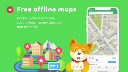
MAPS ME #1 travel maps MAPS.ME is a travel App that provides... #blogema #getdirections #gpsapp #hotelbooking #hotelbookingsites #hoteldeals #mapsanddirections #mapsapp #mapsnavigation #navigationsystem #offlinemaps #openmaps #openstreetmap #osmmanager #tipsandtricks #tour #travel #travelapp #travelblogger #travelguide #travelplanner #traveltips #vacationplanning
0 notes
Photo

MAPS ME #1 travel maps MAPS.ME is a travel App that provides... #cyrrion #getdirections #gpsapp #hotelbooking #hotelbookingsites #hoteldeals #mapsanddirections #mapsapp #mapsnavigation #navigationsystem #offlinemaps #openmaps #openstreetmap #osmmanager #tipsandtricks #travel #travelapp #travelblogger #travelguide #travelplanner #traveltips #vacationplanning https://cyrrion.com/maps-me-1-travel-maps/?feed_id=3369&_unique_id=5f24f09eb3cf5
0 notes
Photo

Become A Google Maps Power User With These Tips And Tricks | MrHacker.Co #googlemaps #googlemapsfeatures #incognitomode #offlinemaps #hacker #hacking #cybersecurity #hackers #linux #ethicalhacking #programming #security #mrhacker
0 notes
Link
All-In-One Offline Maps APK https://apktie.com/apps/all-in-one-offline-maps-net-psyberia-offlinemaps/?feed_id=72058
0 notes
Text
تحميل تطبيق All-In-One Offline Maps v3.5b (Paid) Apk تطبيق الخرائط بدون انترنت لهواتف الاندرويد
قم بتنزيل الإصدار الأخير All-In-One Offline Maps + Apk For Android برابط مباشر
All-In-One Offline Maps + هو تطبيق Android Travel & Local صممه Psyberia ويمكنك تثبيته على أجهزة Android الخاصة بك واستمتع!
يتيح لك All-In-One OfflineMaps + الوصول إلى مجموعة واسعة من الخرائط.
بالملل لانتظار عرض الخرائط؟ بمجرد عرضها ، يتم تخزين الخرائط وتظل متاحة ، بسرعة ، حتى مع عدم وجود وصول إلى الشبكة.
• هل تريد أكثر من مجرد طرق على خرائطك؟ ستجد ما تحتاجه هنا ؛
• تستخدم للذهاب إلى الأماكن ذات تغطية الشبكة الضعيفة؟ كل شيء سيبقى متاحًا ؛
• اعتاد السفر إلى الخارج؟ لن تضيع بعد الآن ؛
• هل لديك حد المسموح به للبيانات؟ سوف يقلل من استخدامك.
يتضمن هذا الإصدار الإضافي جميع ميزات الإصدار القياسي بدون إعلانات ، ويدعم استيراد صيغ GPS الاحترافية وتنسيقات ملفات المعالم الجغرافية (نقاط الطريق ، والمسارات ، والمسارات ، والمناطق) مثل GPX و Google Earth KML / KMZ (تراكبات الخرائط غير مدعومة) و OziExplorer WPT ، CVS / TSV و Geocaching LOC
★★ خرائط ★★
تتوفر الكثير من الخرائط ، بما في ذلك خرائط الطرق الكلاسيكية والخرائط الطبوغرافية والخرائط الجوية (الأقمار الصناعية) والطبقات المختلفة التي يمكن إضافتها على أي خرائط: OpenStreetMap (Roads، Topo) وخرائط Google وخرائط Bing و USGS الخريطة الوطنية (مرحبا الدقة توبو ، صور جوية) ، خرائط توبو السوفيتية العسكرية في جميع أنحاء العالم ، وما إلى ذلك.
• يمكن تكديس جميع الخرائط في طبقات ، مع التحكم الدقيق في العتامة.
• حدد وتخزين مناطق كبيرة في عدد قليل من النقرات.
• المساحة المخزنة واضحة ويمكن حذفها بسهولة.
★★ عرض وتخزين واسترجاع معالم غير محدودة ★★
يمكنك إضافة عناصر مختلفة على الخريطة مثل نقاط الطريق والرموز والطرق والمناطق والمسارات.
يمكنك إدارتها بسهولة باستخدام مستكشف معالم بطاقة SD القوية.
★★ التعريب والتوجيه GPS على الخريطة ★★
يتم عرض موقعك واتجاهك الحقيقي بوضوح على الخريطة ، والتي يمكن تدويرها لتتناسب مع توجهك الحقيقي (يعتمد على قدرات الجهاز).
تشغيل / إيقاف سهل لتوفير البطارية.
وكذلك:
• وحدات المسافات المترية والإمبريالية والهجينة ؛
• GPS Latitude / Longitude وتنسيقات إحداثيات الشبكة (UTM ، MGRS ، USNG ، OSGB Grid ، Irish Grid ، Swiss Grid ، Lambert Grids ، DFCI Grid ، QTH Maidenhead Locator System ،…) ؛
• القدرة على استيراد مئات التنسيقات منها ؛
• عرض الشبكات على الخريطة.
• عرض خريطة ملء الشاشة.
• تقريب متعدد اللمس ؛
• ...
★★ بحاجة إلى المزيد؟ ★★
إذا كنت مغامرًا حقيقيًا ، فجرّب AlpineQuest GPS Hiking ، الحل الخارجي الكامل القائم على خرائط All-In-One OfflineMaps المحملة بمتتبع موقع GPS قوي والمزيد:
Whats New:
3.5b:
• مربع حوار بحث محسّن (الأزرار الجديدة "Clear text" و "Paste from clipboard") ؛
• القدرة المضافة لجعل البوصلة تتجه نحو الشبكة الشمالية.
• تحسينات مختلفة وإصلاح الأخطاء.
تم إلغاء تأمين الميزات المدفوعة
التحميل من هنا
source https://www.tetbekat.com/2020/04/all-in-one-offline-maps-v35b-paid-apk.html
0 notes
Text
All-In-One Offline Maps+ 3.5 build 87 [Android]
Надоело ждать, когда загрузятся онлайн карты? Используйте - All-In-One OfflineMaps! После загрузки карты остаются в программе и всегда доступны даже без подключения к интернету.... Читать дальше »
0 notes
Text
Google plans to move a step ahead..
These days mobile phones are much more than just a phone.We live in the world where people rely on apps on the go. They are our companion or should I say our support system in all chores of life. Imagine a day without your "Smart" smart phone ? No Morning e-papers , No on the go e- billing, No online holiday booking and most important no Navigation (might increase your chance to go missing :P ) etc. Life will be difficult isn't it? Hence Google updated two of its widely used products - google now and Maps, which seeks to make your smart phone smarter .
So, from now "Network problem,No problem" , as you can navigate without using internet .This new feature on Google maps app will enable us to utilize it's features in low connectivity situations like while traveling to remote areas, on subways, on airplanes,or in the underground parking etc.Yay ! Savior it is. Though with some restrictions. With the offline map, users can see reviews of venues, and navigate without an internet connection. Users can even get turn-by-turn voice direction offline too, the company announced at its I/O, an annual conference for software developers. Aiming towards the simple goal "Make traveling and exploring new places easier for people".
How it works?
The only problem we faced with Google maps till now is that it really needs good data connectivity for smooth navigation. But with the introduction of offline maps we don’t have to wait for maps to load in Google maps. Rather,we can save portions of map in Google maps and view them later offline.Although its kind of a hacky trick with some limitations on the map size that can be stored on your phone, which is around 100MB for a single map.But is still helpful.
How to use ?
Excited about this new feature? Than follow these simple steps or the video to save Google maps on your android phone for offline viewing or access :
youtube
Step 1 :
Sign in to your Google Account.
Step 2 :
Install the Google maps app from the Google play store and open it .
Step 3 :
Now, Search any place , say Mumbai. Zoom and select the area you want to save for your future reference . (Make sure you have a good internet connectivity while using google maps ).
Step 4 :
Save the selected area, go to the menu and make it available offline.
Can't wait to check it out, Right ? Go ahead. and Stay tuned for more updates on whats going on.
Juhi Jain, Social Media Manager.
#maps#offlinemap#googlemap#mobile#app#phone#mobileapp#appdevelopment#update#7CStudio#navigation#travel#android#IOS
0 notes
Text
تحميل تطبيق All-In-One Offline Maps v3.5b (Paid) Apk تطبيق الخرائط بدون انترنت لهواتف الاندرويد
قم بتنزيل الإصدار الأخير All-In-One Offline Maps + Apk For Android برابط مباشر
All-In-One Offline Maps + هو تطبيق Android Travel & Local صممه Psyberia ويمكنك تثبيته على أجهزة Android الخاصة بك واستمتع!
يتيح لك All-In-One OfflineMaps + الوصول إلى مجموعة واسعة من الخرائط.
بالملل لانتظار عرض الخرائط؟ بمجرد عرضها ، يتم تخزين الخرائط وتظل متاحة ، بسرعة ، حتى مع عدم وجود وصول إلى الشبكة.
• هل تريد أكثر من مجرد طرق على خرائطك؟ ستجد ما تحتاجه هنا ؛
• تستخدم للذهاب إلى الأماكن ذات تغطية الشبكة الضعيفة؟ كل شيء سيبقى متاحًا ؛
• اعتاد السفر إلى الخارج؟ لن تضيع بعد الآن ؛
• هل لديك حد المسموح به للبيانات؟ سوف يقلل من استخدامك.
يتضمن هذا الإصدار الإضافي جميع ميزات الإصدار الق��اسي بدون إعلانات ، ويدعم استيراد صيغ GPS الاحترافية وتنسيقات ملفات المعالم الجغرافية (نقاط الطريق ، والمسارات ، والمسارات ، والمناطق) مثل GPX و Google Earth KML / KMZ (تراكبات الخرائط غير مدعومة) و OziExplorer WPT ، CVS / TSV و Geocaching LOC
★★ خرائط ★★
تتوفر الكثير من الخرائط ، بما في ذلك خرائط الطرق الكلاسيكية والخرائط الطبوغرافية والخرائط الجوية (الأقمار الصناعية) والطبقات المختلفة التي يمكن إضافتها على أي خرائط: OpenStreetMap (Roads، Topo) وخرائط Google وخرائط Bing و USGS الخريطة الوطنية (مرحبا الدقة توبو ، صور جوية) ، خرائط توبو السوفيتية العسكرية في جميع أنحاء العالم ، وما إلى ذلك.
• يمكن تكديس جميع الخرائط في طبقات ، مع التحكم الدقيق في العتامة.
• حدد وتخزين مناطق كبيرة في عدد قليل من النقرات.
• المساحة المخزنة واضحة ويمكن حذفها بسهولة.
★★ عرض وتخزين واسترجاع معالم غير محدودة ★★
يمكنك إضافة عناصر مختلفة على الخريطة مثل نقاط الطريق والرموز والطرق والمناطق والمسارات.
يمكنك إدارتها بسهولة باستخدام مستكشف معالم بطاقة SD القوية.
★★ التعريب والتوجيه GPS على الخريطة ★★
يتم عرض موقعك واتجاهك الحقيقي بوضوح على الخريطة ، والتي يمكن تدويرها لتتناسب مع توجهك الحقيقي (يعتمد على قدرات الجهاز).
تشغيل / إيقاف سهل لتوفير البطارية.
وكذلك:
• وحدات المسافات المترية والإمبريالية والهجينة ؛
• GPS Latitude / Longitude وتنسيقات إحداثيات الشبكة (UTM ، MGRS ، USNG ، OSGB Grid ، Irish Grid ، Swiss Grid ، Lambert Grids ، DFCI Grid ، QTH Maidenhead Locator System ،…) ؛
• القدرة على استيراد مئات التنسيقات منها ؛
• عرض الشبكات على الخريطة.
• عرض خريطة ملء الشاشة.
• تقريب متعدد اللمس ؛
• ...
★★ بحاجة إلى المزيد؟ ★★
إذا كنت مغامرًا حقيقيًا ، فجرّب AlpineQuest GPS Hiking ، الحل الخارجي الكامل القائم على خرائط All-In-One OfflineMaps المحملة بمتتبع موقع GPS قوي والمزيد:
Whats New:
3.5b:
• مربع حوار بحث محسّن (الأزرار الجديدة "Clear text" و "Paste from clipboard") ؛
• القدرة المضافة لجعل البوصلة تتجه نحو الشبكة الشمالية.
• تحسينات مختلفة وإصلاح الأخطاء.
تم إلغاء تأمين الميزات المدفوعة
التحميل من هنا
from Blogger https://ift.tt/34l34hb via IFTTT
0 notes