#sedimentary structure
Explore tagged Tumblr posts
Visit Tumblr Blog
Explore Tumblr blogs with no restrictions, modern design and the best experience.
Last Seen Tumblr Blogs


Fun Fact
28.6 is the average number of monthly visits per US mobile user.
Text

Huh, ya think it might have rained a little back then?
#maybe a little flood#possibly from some glaciers#could’ve occurred during the last ice age#but I guess we’ll never know#real tags now#geology#sedimentary rock#quaternary#Columbia basin#sedimentary structure
183 notes
·
View notes
Text


Here are some ripple marks from a beach in the Northwest Scottish Highlands! There’s a chance that these ripple marks will be preserved like this and become sedimentary structures that we can see as cross-bedding in an outcrop someday!
#geology#rocks and minerals#rocks#sediment#sedimentary geology#sedimentary rock#northwest highlands geopark#sedimentary structures#ripple#ripple marks#I love sed geology sm and I get judged for it all the time by my peers#sed geologist#sedimentology
4 notes
·
View notes
Text

Outcrop of the day
#geologist#rocks are cool#tumblr people#photography#feldspar#clear quartz#serpentine gallery#metamorphic#igneous#sedimentary rock#structural geology#bearing
16 notes
·
View notes
Text

Bernoulli, Daniel (1936–, geologist). Flute casts, Walkers Bed, Scotland Fm, 28.05.1978.
Clastic sediments: mass flows, sedimentary structures. N of Bowden and River, St. Andrew, Barbados
What are flute casts? Find out here.
#Daniel Bernoulli#flute casts#sedimentary structures#rocks#geology#nature photography#texture#pattern#geologyfordummies
5 notes
·
View notes
Text
2 notes
·
View notes
Text
after 3 hours of back- and knee-breaking work i have transferred the corset pattern to one (1) of the cloths. i haven’t cut it yet because the cloth, while strong, also frays like a stressed unpaid intern, so i am going to sew a line halfway along the seam. (also to keep the curves from…de-curving).
i only have to do this three more times :)))
#yeah it’s four layers#the pretty one the stressed but indomitable intern one the lining one#and then one between the fancy and the intern ones#because the fancy is kinda see through#at least enough for the colour of the structural intern to fuck up the colours enough to bug me#i wish i were writing#but sedimentary me can’t write#(translation: day too shitty to word#which is ironic because sometimes shitty days are dealt with by writing#and yet)#randomness
0 notes
Text
Antediluvian Period Civilizations; Huge Stone Structures Found All Over The World, From Before The Great Flood
ANTEDILUVIAN PERIOD DEFINED IN MANY BOOKS Wikipedia; “The antediluvian (alternatively pre-diluvian or pre-flood) period is the time period chronicled in the Bible between the fall of man and the Genesis flood narrative in biblical cosmology. The term was coined by Thomas Browne. The narrative takes up chapters 1–6 (excluding the flood narrative) of the Book of Genesis. The term found its way…

View On WordPress
#adamitic#ancient#Antediluvian#before great flood#behemoth#Bible#Civilizations#creation story#disobedience to God#fallen angels#fallen angesl#fossils#garden of eden#genesis#giants#gibborim#leviathan#nephalim#pre adamitic#pre diluvian#pre flood#primary rock#sedimentary rock#six ages of the world#stone buildings#stone structures#wickedness
1 note
·
View note
Text
Bryce Canyon National Park, Utah, United States: Bryce Canyon National Park is a national park of the United States located in southwestern Utah. The major feature of the park is Bryce Canyon, which despite its name, is not a canyon, but a collection of giant natural amphitheaters along the eastern side of the Paunsaugunt Plateau. Bryce is distinctive due to geological structures called hoodoos, formed by frost weathering and stream erosion of the river and lake bed sedimentary rock. The red, orange, and white colors of the rocks provide spectacular views for park visitors. Wikipedia
#Bryce Canyon National Park#Garfield County#Kane County#Tropic#Panguitch#Utah#United States#north america#north america continent
528 notes
·
View notes
Text
Paleo-caves in Death Valley
You have probably heard of "caves", or a natural void formed in rock. Caves are formed in a number of ways, but the most familiar are probably those formed in limestone - called karst or karstic. Karst caves are formed by the steady dissolving of limestone rock by naturally acidic groundwater percolating through the ground, often along faults or other natural weak areas.
Death Valley in California is not a hotbed of limestone caves, though evidence of them can be seen in a number of places! Ancient caves, often tens or hundreds of millions of years old, sometimes collapse or fill in with silt/minerals/debris. An ancient cave formation is called "paleokarst", and there are a few areas in Death Valley where you can find it. The easiest to access is in Titus Canyon, a major canyon who's lowest reach carves its way through limestone bedrock, leaving behind towering polished rock walls and revealing the internal structure of the rock.

Titus Canyon's narrow section is carved through the Bonanza King Formation, a Cambrian-age (538 - 485 million years ago) marine sedimentary rock package several kilometers thick. It's found in many areas of Death Valley and the surrounding region. Across its area and thickness, it alternates from dolomite to limestone (dolomite minerals versus calcite minerals). Dolomite doesn't usually dissolve and form caves, but limestone does - and the many fractures in this rock appear to have allowed numerous tiny caves to form somewhere in the distant past. Most of these have since been filled in with calcite minerals, making them paleokarst.

In this image, you can see the void of the cave lined with thinly-layered calcite. It has a flat floor, and these features are characteristic of having formed in a cave. In Titus Canyon, we can find these from a few inches to a few meters across, and as the canyon has been carved into the rock, these voids are exposed. This one below tells an exceptionally clear story:

You don't need to be a geologist to see how this differs from the first example. There's a weird pendant-shaped protrusion hanging from the top, there are layers in the minerals, the bottom half is red… there's a lot going on. Let's get some lines on there and figure out what we can see:

That's better. OK - I've separated out the parts of this outcrop which from my desk look to be distinct. Here's a close-up of part of the left-center area to show how it appears different up close.

OK, so we have the blue-gray limestone bedrock on the right, top, and lower left, then a gray-red area with layers and what looks like gravel or other angular pieces of the limestone. Above that is a finely-layered calcite deposit (remember? that's cave-like!), and above that is a layer of calcite which is rather porous. The top surface of this area is sort of scalloped and curved, which is also characteristic of limestone caves.

Here's the fully interpreted version. Let's go through the sequence of events. First, we have the limestone bedrock of the Bonanza King Formation (BKL). At some time in the distant past, a portion of it dissolved away and formed a cave. Over time, silt and debris filled in the bottom of this cave. Because it is ancient, we call it paleo-fill (OPF). This might have happened at a time when the cave was dry (not containing water), since if it was wet we would expect some amount of calcite to be deposited around its perimeter as is typical in limestone caves.
Above that is a layer of thinly-layered calcite, the cave mineral. This layer contains some reddish silt and the occasional fragment of the limestone, so the cave was probably happily active during the time that was deposited! This is the oldest cave mineralization phase I can discern in this outcrop, so I call it Old Cave Calcite (OCC).
Next, we have a slightly porous, light-colored calcite deposit. The porosity suggests to me that it was deposited faster, but I am not an expert on cave deposits so will not comment further. This unit fills the cave to its top in most places! I call this the Middle-age cave calcite (MAC).
Finally, the youngest unit is another cave-deposited calcite (YCC). As in the first cave picture above, it is a coarser-grained pale yellow color with layers that parallel the sides of the void. Most of the paleo-caves you can find in Titus Canyon are filled with this sort of calcite, and it may be geologically recent (last million years?). It filled the final remnant of this ancient paleo-cave, and is contrasting with the material around it. This visual and textural contrast is what inspired me to write this post in the first place - the best example I've seen in person of paleo-karst and the evolution of a miniature cave system, right in the heart of Death Valley - my favorite place in the world.
#geology#photography#adventures#bettergeology#california#rocks#death valley#death valley national park#cave#paleokarst#limestone#california geology#geologia#i love rocks
97 notes
·
View notes
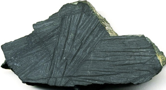
Text

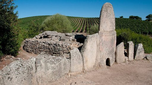
Zebra Schist
Zebra Schist is The tightly folded, thinly bedded schists that are derived from sedimentary rocks that are exposed in Kangaroo Island are known as zebra schists. A quartz-rich and biotite-rich layering largely reflects original sedimentary layering rather than metamorphic differentiation as the secondary biotite preserves and outlines a variety of sedimentary structures.
Small cross-beds troughs and climbing ripples show a sequence facing south. The Geological Society of Australia
has designated this section of the coastline as a geological monument.
84 notes
·
View notes
Text

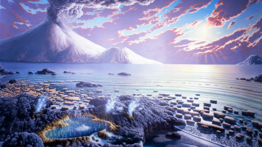
The Paleo Party Guest of the day is the Stromatolite!
Well, this is more of a sedimentary structure than a fossil, they're layers of silt trapped by successive layers of microbial mats! Many types of microorganisms can create stromatolites, like cyanobacteria and pseudomonadota!
Age: Possibly up to 3.4 billion years ago to present!
Stickers || Phone Wallpapers Masterlist
140 notes
·
View notes
Text
Throwback Thursday: Barberton Greenstone Belt
Between 3.5 and 3.2 Ga years ago, during the Paleoarchean era of the Archean Eon, the Earth didn’t look much like it does today. The atmosphere lacked oxygen meaning there was no protective ozone layer, the oceans, the crust had just formed, oceans were forming, and the first living things (cyanobacteria) were slowly creating free oxygen.
In the midst of all this the Barberton Greenstone Belt was also forming. This belt is found in South Africa east of Pretoria. It is a sequence of mafic to ultramafic lava and metasedimentary rocks (metamorphic rocks that still contain sedimentary structures) that were deposited during the Archean Eon. They are the oldest igneous rocks on earth.
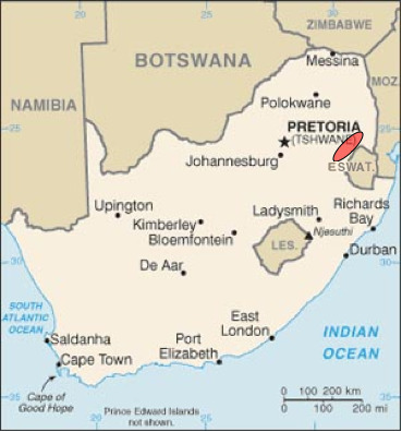
The area underwent two tectonic episodes of terrane accretion, that is two periods of material being added to the tectonic plate at a subduction zone. Imagine it similar to pushing sand in sandbox to form a wall around your sandcastle. This process helped to build new continents throughout geologic time. It is hypothesized that the greenstone belts formed from a passive margin oceanic crust becoming part of a subduction undercut margin.
About 3.1 Ga, a granite batholith was intruded into the belt and partially metamorphosed into gneiss.
Why is it called the greenstone belt? Well, if you recall from earlier lessons (why is magma formed and what is it made of?) mafic and ultramafic rocks are primarily made of olivine, a green mineral. One of the main types of ultramafic rock found here are komatiites, named for the Komati River that flows through the area. It is a mantle-derived volcanic rock with an extremely high magnesium content and very low silicon, potassium and aluminum content.
Komatiites are rare because almost all of them formed during the Archean when it is though the mantle was starting to cool. During this time period, the Earth had much higher heat production simply due to all the residual primordial heat of planetary accretion. In fact, eruption temperatures were thought to be up to 1600 degrees C (2912 degrees F). The lava would have flowed with a viscosity close to water.
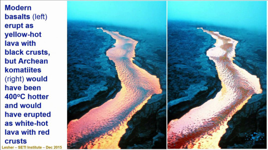
They are composed of forsterite (magnesium-rich olivine),
calcic and chromian pyroxenes,

anorthite (calcium feldspar)

and chromite.

They often take on spinifex texture meaning the crystals look like spinifex grass, long and blade-like.

Thanks for coming to today’s lesson! Tune in tomorrow to learn more about Patagotitan! Fossilize you later!

41 notes
·
View notes
Text


His Dark Materials
This image shows us “fluvial ridge” landforms and fluvial sediment in the Aeolis region of Mars. The dark-toned material may be windblown sand. Where there is such sand, there is the potential that the bedrock is cleanly-exposed, as opposed to covered with windblown dust. Our goal is to examine details of the sedimentary structure, seek better understanding of how this formed.
ID: ESP_075584_1735 date: 10 September 2022 altitude: 267 km
NASA/JPL-Caltech/University of Arizona
71 notes
·
View notes
Text
i learned what are the most mysterious places in the world
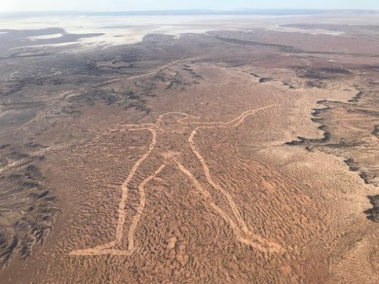
Marree Man – The fact that there is not a single witness to the creation of the Marree Man speaks to the absolute isolation of central South Australia. Somehow in 1998, one person or a group of people were able to create a 2.6-mile long line drawing of an aboriginal hunter, without being seen. In the midst of barren, arid land in South Australia, the Marree Man is the largest geoglyph and work of art in the world. Cut into the harsh landscape with lines over 115 feet wide and one foot deep, the towering Marree Man is easily visible from space. Thirteen years after the Marree Man was discovered during a flyover, little is known about its origin. Although we may never know the true origin of the Marree Man, it is certainly one of most intriguing modern day mysteries.
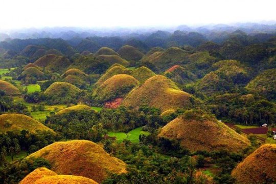
Chocolate Hills – Bohol Island in the Philippines during the dry season, you might notice what looks like thousands of chocolate kisses protruding from the terrain. These mysterious conical mounds are known as the Chocolate Hills. There are approximately 1,268 individual hills, their heights ranging from 100 to 160 feet, though the highest is almost 400 feet high. The hills, which are almost all symmetrical, consist of grass-covered limestone and turn brown during the dry season. Despite the abundance of hills, it is unclear how they were formed. There are multiple geological explanations ranging from oceanic volcano activity to limestone weathering. Numerous legends and tales also exist to explain the Chocolate Hills.
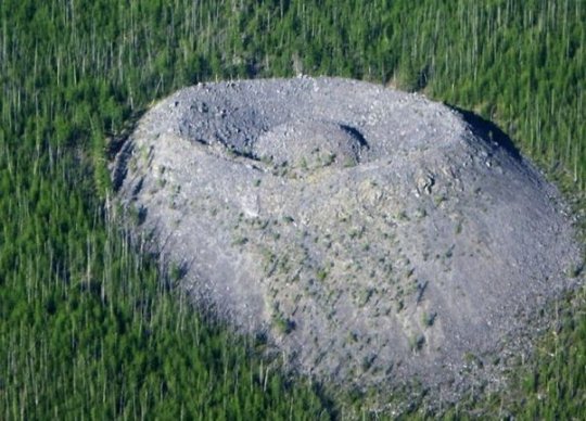
Giants Nest – In 1949 a geologist named Vadim Kolpakov discovered a large mound of limestone in the north of the Irkutsk region in southeastern Siberia. The cone is curiously shaped with a crater at the top and a small mound in the center. The mound is about 40 meters high and 100 meters across at the base. The smaller mound at the top is about 12 meters high. The crater was named Patomskiy, after a nearby river, but local residents call it “the Fiery Eagle’s Nest”. Since the discovery of the crater, there have been many theories as to what could have created it. For a long time it was believed to be a meteorite impact structure. Some linked it to the Tunguska meteorite, whose remains have never been discovered. But the crater does not resemble any other known meteorite site. Even now, the origin of the crater is not discovered.
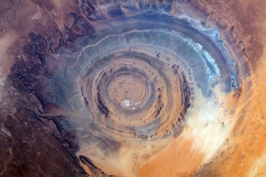
Richat Structure – In the midst of vast, vacant Sahara desert, just outside of Ouadane, Mauritania, lies a 30-mile wide geological oddity known the Richat Structure, sometimes called the “Eye of Africa.” From space, this natural curiosity forms a distinct and unmistakable bull’s-eye that once served as a geographical landmark for early astronauts as they passed over the Sahara. Once thought to be an impact crater due to its circularity, the unusual formation is now widely believed to have been caused by the erosion of a geological dome formed by pressure from a bulb of molten magma below.
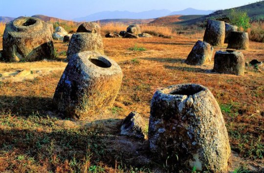
Plain of Jars – The Plain of Jars is a collection of large stone jars interspersed throughout the Xieng Khouang plain in the Lao Highlands. The stone structures are mostly made of sedimentary rock and, ranging from 3 to 10 feet in height, each can weigh up to 14 tons. To date, the origin of the jars is unknown, though archaeologists believe that they were originally used between 1,500 and 2,000 years ago. Many researchers have theorized that the jars may have once served as funerals urns or food storage. As local Laotian legend would have it, the jars were created by Khun Cheung, an ancient king of giants who lived in the highlands. It is said that Cheung, after fighting a long and victorious battle, created the jars in order to brew huge amounts of celebratory lao lao rice wine.
Giant’s Grave of Coddu Vecchiu – Giant’s or Tomba Dei giganti, are megalithic gallery graves that were used as public tombs during the Bronze Age. The massive gravestones were built by the Nuragic civilization, which existed in Sardinia from the 2nd millennium BCE. to the 2nd century CE. Despite the imaginative name, the sites were not the burial site of any giant; they were giant community burial chambers. Though we know the tombs had a funerary purpose, more questions remain. Little is known about the rituals or traditional beliefs that motivated their construction. Were they mass graves? Were they built to facilitate the journey into the afterlife? Since their existence has yet to be justified by scientific research, they have been credited to the supernatural, which has only increased their mystery. Legend also claims that yes, indeed, these were the tombs of powerful giants.
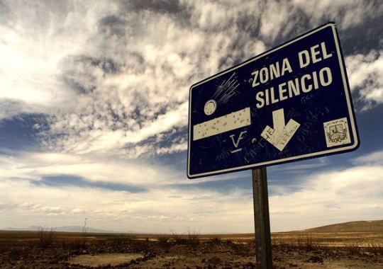
Zone of Silence – Pilot Francisco Sarabia was flying over a patch of desert land in Mexico when his instruments started to act increasingly odd. The man had to make an emergency landing in the middle of nowhere. Little did he know that this "nowhere" would be later dubbed "The Zone of Silence.” Weird radio silence isn't the only oddity of the creepy Zone. Like, what’s that weird trio that locals keep meeting in the Zone? They’re two men and a woman. Every time people see them, they’re wearing bizarre clothing that isn't suitable for a journey in the desert whatsoever. On top of all that, the Zone of Silence is known as a 50 km patch of deserted land where meteorites come crashing down on an eerily regular basis. On July 11, 1970, the US launched an ATHENA rocket from the Air Force base in Green River, Utah. The rocket was supposed to land somewhere in the area of White Sands in New Mexico. Instead, it went off course and, as if being pulled by some external force, crashed right in the heart of the Zone of Silence.
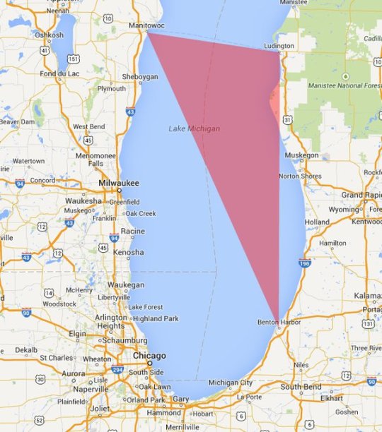
Michigan Triangle – Stretching from Ludington to Benton Harbor, Michigan and to Manitowoc, Wisconsin, the Lake Michigan Triangle has inspired numerous accounts of activity that are difficult to explain by rational thought. The mystery began in 1891, when a schooner named the Thomas Hume set off across the Lake to pick up lumber. Almost overnight in a torrent of wind, the Thomas Hume disappeared along with its crew of seven sailors. The wooden boat was never found. After the turn of the century, strange events happened at steady intervals. Of the more mysterious is the case of the Rosa Belle. In 1921 eleven people inside the ship, who were all members of the Benton Harbor House of David, disappeared and their ship was found overturned and floating in Lake Michigan. While it appeared that the ship had been damaged in a collision, no other ship had reported an accident and no other remains had been found.
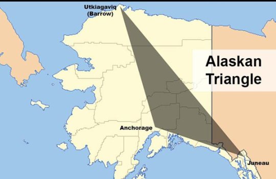
Alaska Triangle – The Alaska Triangle is a place in the untouched wilderness where mystery lingers and people go missing at a very high rate. The area began attracting public attention in October 1972, when a small, private plane carrying U.S. House Majority Leader Hale Boggs, Alaska Congressman Nick Begich seemingly vanished into thin air. For more than a month, 50 civilian planes and 40 military aircraft plus dozens of boats, covered a search area of 32,000 square miles, but no trace of the plane, the men, wreckage or debris were ever found. Afterward, more planes went down, hikers went missing, and Alaskan residents and tourists seemed to vanish into thin air. In fact, since 1988, more than 16,000 people have disappeared in the Alaska Triangle, with a missing person rate at more than twice the national average. These disappearances are blamed on everything from severe weather to aliens, to swirling energy vortexes, to an evil shape-shifting demon of Tlingit Indian lore called Kushtaka, with no scientific explanation to the disappearances till today.
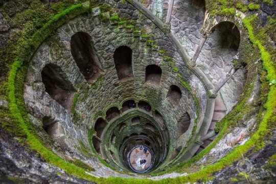
The Initiation Well – The Initiation well is 88 feet deep well located on the land of Quinta da Regaleira. Actually, it was used for ceremonial purposes. There is another small well near this well. Both these wells are connected by tunnels. The larger well contains a 27-meter spiral staircase with several small landings and the smaller well contains straight stairs that connect a series of ring-shaped floors to one another. The smaller well is also called the 'Unfinished Well'. The depth of this larger well is equal to the four-storey building, which becomes narrower on going closer to the ground. It is believed that there is some kind of light comes out from the well inside the ground and comes outwards. Surprisingly, there is no system of light inside this well, then where from this light comes, it is the secret. Anyone who comes to visit here, always raises the question of where the light comes from inside the well? Till today this secret is unsolved.
(Image Source : Google)
Thanks for Reading.
694 notes
·
View notes
Text

Daniel Bernoulli. Drag marks & superposed flute c., 9/1987.
Read about Sole markings here
#Daniel Bernoulli#photography#geology#rocks#sedimentary structures#texture#pattern#nature#geologyfordummies
1 note
·
View note
Note
On the subject of minerals/rocks, if naturally occurring ice is a mineral, does that make glacial ice a weird type of regional metamorphic rock?
Thanks so much for your fun question, anon! Apologies that it’s taken the team a little while to respond!
The short answer is, yes! Ice is the crystalline, or solid, form of water - it’s naturally occurring, inorganic, has a definite chemical composition (H₂O), and has a defined and organised crystal structure (as seen below) - so by all accounts, a block of ice is what we would call a mono-mineralic rock!

Fig. 1: Crystalline structure of ice, or solid water. Doesn’t that structure look familiar? There’s a reason that snowflakes look the way they do, and that’s because of that beautifully organised crystalline structure!
You are absolutely correct in that glacial ice meets all the requirements to be classed as a metamorphic rock, too!
But, why?
Well, we won’t divulge too much as we’ll be talking about the different rock types in our next big post - but for the purpose of this ask we’ll do a quick crash course in sedimentary and metamorphic rocks.
Let’s start with sedimentary basics. When talking seds one of the best ways to imagine your rock is like a layer cake. Let’s say you’re making a chocolate and vanilla layer cake. Your chocolate batter represents mud, and your vanilla batter is sand - they each have a different colour and texture. You lay your muds down first, then your sands. You can keep doing this again and again if you wish, until you have lots of layers. Then, you bake! The baking represents the many millions of years it takes for these sediments to solidify into a solid rock (although you technically don’t need heat for real rocks). Do note that in reality it’s not quite as simple as this, there are many things that affect ways that rocks solidify!
Now imagine just a plain old chocolate cake. No frosting or filling. Just chocolate sponge. We layer up the chocolate sponge and bake. Boom, we have a whole unit of just mudstone.
The origins of glaciers are exactly the same, except your mudstone is snow! Lots and lots of snowflakes that have built up over time.
Okay, but what about the metamorphism? Metamorphic rocks start out pre-baked, if we’re using our cake analogy, so we already have our snow layers. Metamorphism of rock occurs either due to heat or pressure - or both. We don’t have heat when it comes to ice, but we do have pressure! Lots of pressure, actually - caused by the weight of all that snow piling up and up. As the weight increases, the ice at the bottom gets squashed which causes the crystals to change shape or recrystallise into ice.
Now think back to our cake. If we kept layering up layers and layers of baked cake, eventually the bottom layer would get squashed, altering the texture and making it really dense. The same thing is happening here! Turning soft snow into hard ice. And then this keeps happening, compressing the ice even more to form glacial ice! Also cool to note that the “texture” of normal ice under the microscope is very different to that of glacial ice!
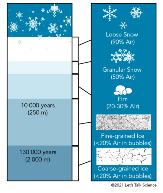
Fig. 2: Diagram showing how glacial ice is formed. Note the different texture and size of the "crystals" between the fine-grained and coarse-grained ice! Original image from Let's Talk Science.
This recrystallisation is a really key part of metamorphism in rocks, too, with metamorphic textures being one of the main diagnostic features that geologists use to categorise different types of metamorphic rocks - limestone to marble, for example!

Fig. 3: Petrographic slide images showing limestone (left) and marble (right) showing the recrystallisation effects of metamorphism. Note how different the shapes are! Marble and limestone are made of the same building blocks (CaCO₃), but have different properties because of this! Original images from Alex Strekeisen's incredible website for all things optical petrography.
Now you can be a cool geologist at parties and let folks know the ice in their drink is technically a rock!
(DekkiiDan does this. Merrydock does this. So does Mohs. We are cool.)
Anyway, hope that answers your question! It was a really fun one, hehe!
See you in the next loop! The OWGS Team
23 notes
·
View notes