#segontium
Text


Two carvings of the Roman god, Mars, in sandstone and mudstone, Segontium, Caernarfon, St. Fagans National Museum of History, Cardiff, Wales
#roman#roman fort#segontium#caernarfon#roman god#mars#roman belief#roman deity#roman culture#roman army#roman empire#relic#stone carving#ancient design#ancient craft#ancient culture#wales
61 notes
·
View notes
Photo

The majestic Caernarfon Castle, a Welsh beauty in a photography from @lathengriffiths . . . More shots from inside the magnificent Caernarfon Castle, North Wales. . . . #castles #Wales #NorthWales #northwalestagram #caernarfoncastle #caernarfon #middleages #royalfortress #castle #gwynedd #segontium #stronghold #castello #castelli #welshcastles #castlesofwales #castillos #castillo #castlephotography #castelo #schloss #castelos #chateaudelaloire https://www.instagram.com/p/B8yCUvigMe2/?igshid=1g5y63eu4dg4j
#castles#wales#northwales#northwalestagram#caernarfoncastle#caernarfon#middleages#royalfortress#castle#gwynedd#segontium#stronghold#castello#castelli#welshcastles#castlesofwales#castillos#castillo#castlephotography#castelo#schloss#castelos#chateaudelaloire
0 notes
Text
The Nature and Extent of Irish Raids on Britain after the Retreat of Rome
Some basic background:
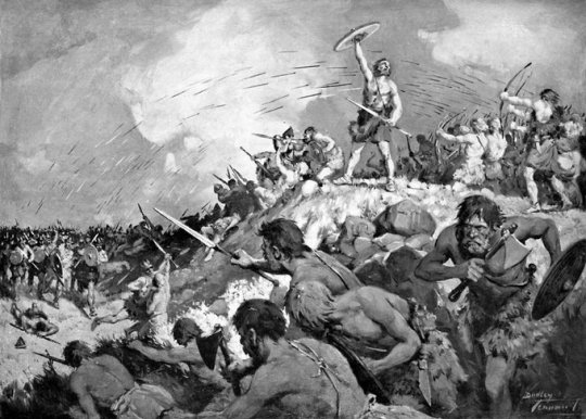
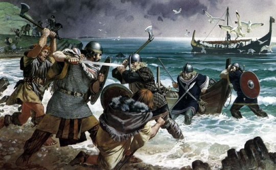
The Roman Empire had been waning in Britain for hears and finally retreated for good in 407 AD. When Rome first conquered Britain, they of course couldn't allow them to retain an independent army, which risked revolt. Rome was their army. When Rome left the Britons were left with their warrior caste carved out of society. Laws set by the Romans had prohibited the natives from bearing arms at all outside of the military. This ban was lifted in 410 AD when Emperor Honorius told the British cities to "look after themselves." Britain was now ruled by local princes, who often petitioned Rome for military aid, begging for help against encroaching invaders. Saxons from the East, Picts from the North, and the Irish from the West, each as vicious as the other.
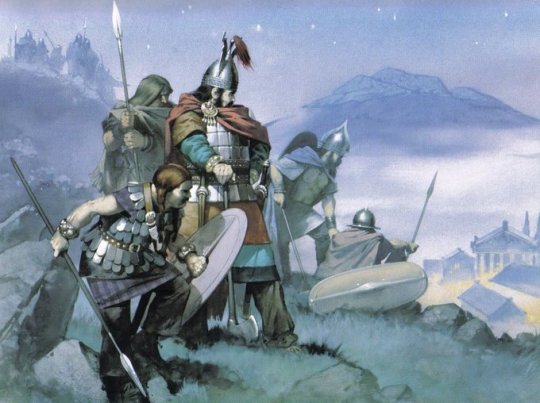
That is no exaggeration. We often play up the power of the Saxon at the expense of the others. Roman writer Ammianus Marcellinus called the raids a conspiratio barbarica, and the Annals record almost as many Irish and Pictish raids as Saxon ones. Outside the reach of Rome, men were still wild.
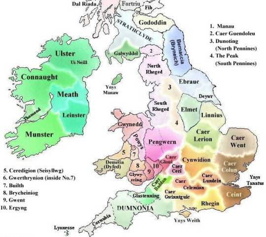
The five kingdoms of Ireland (cóiceda) were fighting amongst themselves, but like the Norwegians centuries later, internal conflict never deterred expansion. The most Irish-afflicted areas of Britain were the south west of Wales (Pembrokeshire, a.k.a. Dyfed), Cornwall (Dumnonnia), and Argyll (Dál Riata). How extensive were these raids? They were settlements. The ruling dynasty of Dyfed came from Leinster. Many places such as Dyfed or Lleyn were bilingual with Gaelic, at least among the nobility. Many ogham stones from this area (the most in all of Britain) are written in Gaelic, not Brythonic. Many place names in Wales to this day derive from Irish or reference Ireland, such as Llyn Iwerddon, "Lake of Ireland", in Caernarvonshire. Another is Dolwyddelan (Dole-with-eh-lahn), which derives from Gwyddelan and Gwyddel, which is a Welsh term for a Gael or Goidel. Many such terms. A Welsh poet might call another poet's work "diseisnig" and "diwyddelig", that is, untainted by English or Irish. But make no mistake, the Irish in the end left no major genetic impression on the Welsh population. In this instances it was merely a temporary occupation of the upper classes by nobles funded by Irish kings.
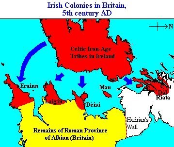
The raids of the Irish did not begin once the Romans left. It was continuous, and the Romans and Welshmen had previously constructed defensive forts at Caerleon and Caerwent, and later at Cardiff. A fort at Segontium was used to guard the Roman copper mines on Ynys Mona from the Irish raiding parties. Nonetheless the Irish broke through once Rome left. Cormac's Glossary tells us the following:
"The power of the Irish over Britain was great, and they divided Britain between them into estates... and the Irish lived as much east of the [Celtic] sea as they did in Ireland... and their dwellings and their royal fortresses were made there. Hence Dind Tradui... the triple rampart of Crimthann Mór, son of Fidach, king of Ireland and Britain as far as the English Channel... and they were in control for a long time, even after the coming of Patrick."
Now what could this mean, that the Irish lived as must east of the sea as west? Perhaps the Britons, like the Picts under the Gaels and the East Britons under Saxons, began to call themselves "Irish", while maintaining a Welsh underground identity. We have to remember that after Britain had been militarily and culturally dominated by Rome, it was easy for barbarians to impress a new culture onto the Britons. The Romano-Britons spoke Latin (mostly) and wanted to have Roman culture, but this was a one-sided and unstable relationship ripe for replacement with a nearer culture.
The territories of Devon and Lancashire were strongholds against the encroaching Irish powers, stopping the Gael from traveling further inland or northward. The threat of an Adventus Scottorum kept the western kings awake at night. The Severn Sea (modern Bristol Channel) was the stage for major Irish settlement into Devon. Linguistic and historical evidence shows that most of the Britons who fled to Brittany originated in Devon, contrary to Gildas' accounts of Central and Eastern Wales. The traditional narrative of Saxon invaders forcing the Britons of the Welsh Marches across the sea can't be true. The Armorican migration was occurring in the 4th, 5th, and 6th centuries, but Saxon power hadn't reached Wales until the after the Battle of Mount Badon c. 500. Yet the Roman Armoricans had begun allying with and giving land to immigrant Bretons in 409 AD, to bolster their numbers against a continental Saxon scare. The eastern Anglo-Saxons could not have been the cause of the Breton migration, but the western Irish were. The Irish settlements and raids on the Cornish coast of the Severn Sea depopulated the area of its inhabitants. When the Anglo-Saxons reached the area, there were no Celts to retain place names, hence the strange preponderance of English toponymy in Devon.
North Wales and Cumbria (Rheged) formed twin kingdoms to repel Irish and Saxon raids. The south called Deheubarth meaning "the Right Hand", and the north called Gwyr y Gogledd meaning "the Left Hand." These brother peoples often relied heavily on each other for defense.

The Irish settlement of Argyll and the surrounding Isles left a much more distinct genetic and cultural mark. The raiders into Argyll and Galloway established the kingdom of Dál Riata, with its power center at the modern ruins of Dunolly Castle at Oban, and it's monastery at Iona. Before the invasions into Argyll in the 5th century, all of Alba was ruled by Picts and Pictish families. In the East, Picts ruled until the 9th century. The "Picts" (which is a Latin name) likely called themselves Cruithni, and spoke a maybe-not-Indo-European tongue, though it had much in common with Brythonic. The conquest of Pictland began when King Fergus Mór and his two brothers led a fleet of 150 men to conquer a number of Western Scottish Isles. They set up their clifftop fortress at the Rock of Dunadd, and expanded eastward from there. The next great King was Aedán Mac Gabráin, who went out to conquer the Orkneys, Hebrides, and all of mainland Scotland as far as Perthshire. These maps don't really show it, but Aedán won a battle in the Orkneys against a Pictish King in 580 AD and won. Dál Riata was powerful. A few generation after the death of Aedán, the Dál Riatic Kingdom was starting to conquer or merge with the Eastern Pictish kingdoms to form the modern kingdom of Scotland. Aedán's immediate successor, Eochaid Buide, was already called "Rex Pictorum.” Irish Gaelic (which would morph into Scots Gaelic) was the language of the royal courts in Pictland, and eventually trickled down to the lower classes, as languages usually do. Folklore also spread from Ireland into Pictland; Scottish folklore today is from the same root as Irish. And although the Ulster Irish kings left a large genetic mark on the western highlands and Galloway, the main expansion of the Irish was political, linguistic, and cultural, adopted by the Picts or Britons from above.
Infighting between the Ulaid dynasty within Ulster, along with later Viking maritime power, eventually severed the Scottish Gaels from the Irish Gaels, and Dál Riata was free to focus its attention on uniting Scotland against Vikings and Bernicians. And for some reason, the Irish raiders never had much interest in Rheged. It was left mostly untouched, even in the early days. Though today this area has a strange preponderance of Scandinavian place names instead of Saxon ones. This is because in 902, the Irish Kings repelled the Vikings from Dublin, who then migrated across the sea into Cunbria and Rheged. So there was no difficulty in physically going there, but for some reason the Irish didn't.
#britain#ireland#history#irish history#raids#celtic history#anglo-saxon#welsh#wales#briton#medieval#dark age#vikings#celts#celtic#irish#english#england#saxon#british history
13 notes
·
View notes
Text
1822 Saturday 20 July
6 10/60
1 1/2
My aunt called me at 6 10/60 - got up immediately - all quite ready for being off after breakfast - my aunt and I went out a few minutes before 8 - walked to the top of the hill behind the hotel - The view is certainly very fine - high water - very hot and close, portending rain - returned to the house, turned down a narrow sort of passage lane to the shore of the Menai, thence along the fashionable walk of the town (a sort of rampart-walk, broad and neatly gravelled) at the foot of the town-wall along the Menai - round the castle to queen Eleanor’s gate - here (at 9 10/60) my aunt (being a little rheumatic) left me and returned home - I pursued the stream of or rather river along the Seiont in pursuit of traces of old Segontium - passed a little square remain - came to a bridge of 2 or 3 arches across the river (beautifully wooded for a considerable distance on the opposite bank) a neat white washed house or 2, a turnpike and 2 roads on the other side, and little cascade just on this side of the bridge and very pretty view - turned up the hill on my left - an uneven surfaced stony grass-grown mound, probably the site of ancient buildings - crossed a field and came into a road - passed close by the farm-house, built adjoining the round tower remain of the old Roman fortification - the wall seemed the farm-yard boundary on one side, and so covered with ivy on the other I could make nothing of it - In fact, I was uncertain about identity (foolishly not having a guide with me) and had not time to loiter. Strolled thro’ the town to the market place - fine mutton 4 d. a lb. veal 3 1/2 - Saw no beef - neat, small covered market place thence to the Goat Inn - and thence inquired my way to the bank - not open - a young man at the door, civilly let me in, and gave me 10 sovereigns for a £10 bank of England and would charge nothing - the Welsh prefer county notes to bank of England there are so many forged - went direct home by the walk along the Menai, and sat down to breakfast immediately at 10 1/4 -
Very good house - very civil people, and we may safely recommend our friends there - It would be a good place for head-quarters - Like the town of Caernarvon very much - Fine view of the castle this morning, a little from the town on the bank of the Seiont - most beautiful remain of castle architecture - Mr Battiss of the hotel saw us off, gave us his card, and hoped we had been comfortable -
Off at 11 1/4 - perhaps 1/2 mile on our road (the Beddgelert road) we came to a cottage forty or fifty yards from a neat, white washed church - at this cottage I got out and turned into the field on our right to see the old Roman wall or fort described by Bingley volume 1 page 170, et sequitor and vide Nicholson’s guide page 283 - I had seen the opposite extremity before breakfast - stopt 1/4 hour - ran along the remain inside and out to find a place free from ivy, or grass, or brushwood - it is almost wholly covered with one or the other so as to resemble a bank fence - however at the extremity of the field next the road there is a bare part which shews the Roman method of building and farther on (thro’ a gap) I discovered 1 or 2 of the small perforations so much spoken of thro’ the wall transversely - vide King’s munimenta on the Roman manner of building -
We reached here Beddgelert the Jones’ arms at 2 35/60 (Mr Jones of Caernarvon owner of the new Inn) a neat, nice house; beautifully situated to the right, a little above the village, and across the stream - planted all about and then embossed in wood - remarkably pretty - very fine drive from Caernarvon here - Bettws Garmon only 2 or 3 poor cottages - noticed Nant Mill - very pretty little cascade - quite close to the road on our right, and too little fence to protect us from the stream - noticed also Williams’ - white or yellow washed - plantations about the house (larch trees as there are here about the Inn) and very pretty - the pass or entrance to Beddgelert very narrow rugged and singly fine - on entering it, and coming down the hill, I could not help saying to my aunt this is the prettiest sublime we have seen - the village is in as it were a small basin formed by high rough mountains - the rock darkened with heath or moss and finely bare here and there - the bottom of the basin beautifully verdant with here and there trees about the few cottages, and a stream tumbling over its rocky bed thro’ the midst - it is fact far the most picturesque village we have yet met with - some very heavy showers as we came along - the clouds tremendously black - the top of Snowdon quite enveloped - got here in the beginning of a very heavy shower -

Bedgellert 1814 - image credit: Wikimedia Commons
Just 3 35/60 i.e. an hour since we got in - Looking a little at Bingley and Nicholson’s Cambrian guide - At 4 took a little girl to carry the plaid and umbrella, and set off to Dinas Emris about 1 1/2 mile on the Capel Curig road to Cwm cloch - we had gone little more than a mile, when the poor child began to cry, and I sent her back again - walked forwards 2 miles (i.e. about 1/2 mile beyond Dinas Emris) a little way along Lake Dinas - small house at the end of it, and some green fertile looking fields - a little plantation about the house - I longed to have gone further as far as Lake Gwinant - the scenery as far as I did go, very fine - got back at 5 10/60 in the midst of a heavy shower - very hot with walking -
Off from Beddgelert for Tan-y-bwlch at 5 35/60 - the scenery for the first 3 miles terrifically fine - Pont-aber-glaslyn bridge tremendous - the road for a good way down to it narrow and no fence or merely a single row great stones to guard the precipice - there is no great cataract - but the unguardedness of the road, the torrent tumbling over rocks below and the perpendicular rock to the height of 2 or 3 hundred feet on the other side form a most impressive scene - there is a turnpike just beyond the bridge, thro’ which we went up a tremendously steep hill, from which a fine view down an opening upon the Traethmawr sands - Indeed the whole stage (they called it 10 miles at Beddgelert) is tremendously hilly - the scenery is indescribably fine - the first about 3 miles and the last about 2 cannot surely be exceeded - but the whole far surpassed anything we had seen - Penman Mawr is a different sort of thing should be excepted and should not be compared with it - Very fine peeps of Wyddfa at intervals, and the Glyder vawr - never saw Wyddfa to such advantage - In short, no one travelling in Wales should miss the drive from Beddgelert to Tan-y-bwlch - the road in many places not at all fenced off from the precipice on one side - my aunt sick with fright more than once - several heavy showers as we came along just in our faces, particularly for 50 or 100 yards just after leaving Beddgelert, and for the last 1/2 mile - the Inn most beautifully situated at the foot of an almost perpendicular steep wooded from top to bottom - tremendous descending the road down it - a most comfortable Inn -
Sat down to dinner at 9 1/2 (got here in 2 20/60 hour at 5 minutes before 8) fryed salmon, a very small fish cut in slices - a roasted loin of mutton and apple tart and cream - the best potatos I have tasted in Wales - the mutton most excellent, the best we have had - we have enjoyed our dinner exceedingly and both had a nap since - my aunt is just gone to bed - instead of wine, a bottle of very fair cider - they get it from Bristol - Did not begin this page till 10 50/60, and it is now 11 1/2 - Very heavy showers repeatedly during the day - but tho’ we had our coats etc dried at Beddgelert and here, we escaped getting much wet - 12 miles from Caernarvon to Beddgelert 10 from Beddgelert here the roads roughish and very hilly, very particularly this last stage, yet Percy came in not at all tired - He is a capital gig-horse - went upstairs to bed at 11 40/60 - Sat up reading Nicholson’s Cambrian guide, article Harlech, etc - and looking over our accounts - a great deal of discharge yesterday and today and ever since I left home -
Reference: SH:7/ML/E/6/0029
4 notes
·
View notes
Photo


Man's Impact on the Environment
Caernarfon Castle
Caernarfon, Gwynedd, Wales
Caernarfon Castle (Welsh: Castell Caernarfon), often anglicized as Carnarvon Castle, is a medieval fortress in Caernarfon, Gwynedd, north-west Wales cared for by Cadw, the Welsh Government's historic environment service. It was a motte-and-bailey castle in the town of Caernarfon from the late 11th century until 1283 when King Edward I of England began replacing it with the current stone structure. The Edwardian town and castle acted as the administrative centre of north Wales and as a result the defenses were built on a grand scale. There was a deliberate link with Caernarfon's Roman past and the Roman fort of Segontium is nearby.
While the castle was under construction, town walls were built around Caernarfon. The work cost between £20,000 and £25,000 from the start until the end of work in 1330. Despite Caernarfon Castle's external appearance of being mostly complete, the interior buildings no longer survive and many of the building plans were never finished. The town and castle were sacked in 1294 when Madog ap Llywelyn led a rebellion against the English. Caernarfon was recaptured the following year. During the Glyndŵr Rising of 1400–1415, the castle was besieged. When the Tudor dynasty ascended to the English throne in 1485, tensions between the Welsh and English began to diminish and castles were considered less important. As a result, Caernarfon Castle was allowed to fall into a state of disrepair. Despite its dilapidated condition, during the English Civil War Caernarfon Castle was held by Royalists, and was besieged three times by Parliamentarian forces. This was the last time the castle was used in war. Caernarfon Castle was neglected until the 19th century when the state funded repairs. In 1911, Caernarfon Castle was used for the investiture of the Prince of Wales, and again in 1969. It is part of the World Heritage Site "Castles and Town Walls of King Edward in Gwynedd".
The first fortifications at Caernarfon were built by the Romans. Their fort, which they named Segontium, is on the outskirts of the modern town. The fort sat near the bank of the River Seiont; it is likely that the fort was positioned here due to the sheltered nature and as traffic up the Seiont would have been able to supply Segontium. Caernarfon derives its name from the Roman fortifications. In Welsh, the place was called "y gaer yn Arfon", meaning "the stronghold in the land over against Môn"; Môn is the Welsh name for Anglesey. Little is known about the fate of Segontium and its associated civilian settlement after the Romans departed from Britain in the early 5th century.
1 note
·
View note
Text
December 3, 2021
Start of the final month of 2021 and once again a metric shit ton of good releases. The last three or four months have been absolutely insane with one quality release after another.
Biggest surprise for me was actually Volbeat. I really dug their early albums but they had lightened up their sound so much it was almost like a different band. Well this album has some serious heavy moments (Track 11 Becoming actually has some really nice tremolo riffing). From there the parade of Black Metal roles on. Agony by Default were the early front runners for album of the week with Spatial Dimensions not far behind but then Sunday night I ran into Hands of Despair and the best black metal album of the weekend was chosen. Great mix of Melodeath, black, prog and even some thrash moments here and there. Bloodmessiah, Redemptor and Once upon the End held down the death and Melodeath fort with some killer albums but my pick was Unanimated for best of the week for Death Metal. In the best album with the worst band name we Have Rachel Mother Goose. The album Synra Bansho is an excellent Power Metal album just slightly outdone by Defiant and their album No More Pain. In the Heavy (including doom) Metal no one came close to Nekromant and their album Temple of Haal. Tell me that doesn’t sound like a “cvlt black metal” release from the early 2000’s. Also worthy of note is Aquilus. Yet another album that requires more listens instead of the quick turn and burn I do on the weekends. It could end up being the release of the week. I did order the vinyl so we will see.
As always,
BANG THY HEAD!
Blackhearth-The Wrath of God(heavy power)
Wreck-Defy-The World Enslaved(thrash)
Morcolac-A Vampiir is Born(black)
Bad Business-Shotgun Woman(Hard Rock)
Volbeat-Servant of the Mind(heavy/hard rock)**
Agony by Default-A Serenade for Eternity(symph black)**
Through the Spatial Dimensions-Nothing is Real(black)**
Alchemia-New Reality(Hard rock/heavy)
Sun of the Endless Night-Life…a Tragedy Tainted by Malevolence(thrash)
Eternal War-Let the World Burn(heavy/thrash)
Custard-Imperium Rapax(heavy/power)
Pyrexia-Gravitas Maximus(death)
Oathean-The Endless Pain and Darkness(symph black/Melodeath)*
Bloodmessiah-Denounce Your God(death)*
Temple of Evil-Apolytrosis(Black)
Redemptor-Agonia(tech/prog death)*
Unanimated-Victory in Blood(Melodeath)*
Nekromant-Temple of Haal(heavy/doom)**
Cutterred Flesh-Sharing is Caring(death)
Max Pie-Passengers(Power)
Defiant-No More Pain(power)*
Aquilus-Bellum I(meloblack)*
Once Upon the End-The Next Chapter(Melodeath)**
Psychoprism-R.I.S.E(prog power)
Rachel Mother Goose-Synra Bansho(power)*
Wolven-Misanthropy and Other Grim Tales(Melodeath)
Orkhys-A Way(power/folk)*
1000 Odios-Placebo and Terror(Melodeath/thrash)*
Hands of Despair-The Crimson Boughs and Other Short Tales(prog/death/black)**
Castle of the Winds-Until Segontium Burns(meloblack)*
Ancient Obscurity-Nimettomat Maat(black)*
Devil Electric-Godless(heavy/doom/goth)
Slave Agent-Alternate Histories(thrash)*
All worthy of a listen if you like the genre
*= standout in that genre
**=best of the week regardless of genre
Isabella the Bulldog gives a solid 4.25 paws up for Dec 3, 2021 Pick of the Week, Hands of Despair - The Crimson Boughs and Other Short Tales.

1 note
·
View note
Photo

I can’t believe how amazing this #caernarfoncastle is. Not only is it so historical it amazing “Caernarfon Castle (Welsh: Castell Caernarfon Welsh pronunciation: [kastɛɬ kaɨrˈnarvɔn]) – often anglicised as Carnarvon Castle or Caernarvon Castle[1] – is a medieval fortress in Caernarfon, Gwynedd, north-west Wales cared for by Cadw, the Welsh Government's historic environment service. It was a motte-and-bailey castle from the late 11th century until 1283 when King Edward I of England began to replace it with the current stone structure. The Edwardian town and castle acted as the administrative centre of north Wales, and as a result the defences were built on a grand scale. There was a deliberate link with Caernarfon's Roman past,[citation needed] and the Roman fort of Segontium is nearby.” Great Britain has do much to offer and Wales 🏴 #wales is my favourite. (at Caernarfon Castle) https://www.instagram.com/p/CR_8pnWjOAZG8KfKA0o9Kk6ThWA9H4aBc9bmYg0/?utm_medium=tumblr
0 notes
Text


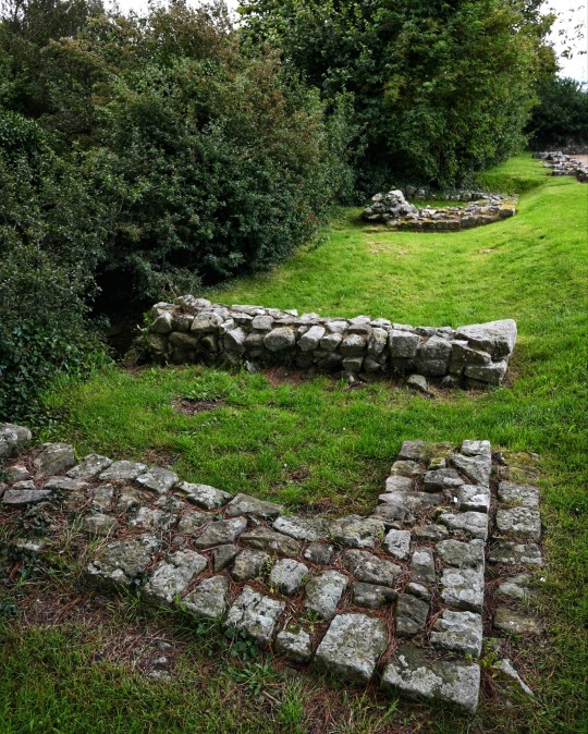
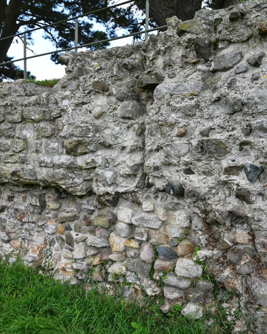
Segontium Roman Fort, Caernarfon, Wales
#roman army#roman fort#roman living#roman empire#roman building#romans#roman gatehouse#archaeology#ancient living#ancient craft#ancient cultures#segontium#Caernarfon#Wales#roman ruins#foundations
39 notes
·
View notes
Text
Western Roman Campaign, 396-397

As before, I’ve made nice maps for you. Dots/words in yellow are cities that are relevant. Words in white (or black in the case of the Jutes for visibility purposes) are faction names, with their relationship with Western Rome in parenthesis. Blue arrows are enemy troop movements while red are my own troop movements.
The war in Britannia continued to rage as the end of the 4th century loomed. At this time, the Picts and Caledonians in northern Britannia and the native Ebdanians of the neighboring island of Hibernia had all declared war and began raids throughout the province of Britannia Inferior. The Saxons, hailing from Germania, also had a sizable army in Britannia. However, the Saxon homeland in Germania was under siege by Roman forces hoping to eliminate them as a threat. The Caledonians had been besieging the walled city of Eboracum for just about a year, while the smaller towns of Lindum and Segontium, which had no walls, faced frequent looting from the Ebdanians.

By the end of 397, all of Britannia Inferior had fallen. Eboracum finally succumbed to the siege by the large Caledonian army, shortly followed thereafter by a rebellion taking control of the town of Segontium. The rebel group, styling itself “Britain” and operating as an independent Romano-British nation, took control of the western-most region of Britannia Inferior, and thus far the central Western Roman authority has enough on its plate in Britannia that it will tolerate this independent faction without hostilities for the time being. Finally, Lindum, which had just about been reduced to rubble by raiders, was occupied by the Picts.
The Saxons in Brittania went on an offensive push to attempt to destroy the 6th Legion in Camulodunum, which was being rebuilt after a big defeat was dealt to it by the Franks previously. Thankfully, the newly rebuilt legion repelled the attack easily, and then chased the Saxons down to destroy their army. This meant that all of the remaining Saxons were holed up in their capital of Tulifurdum, which was under Roman siege. The Saxon King, Gewis, rallied his soldiers in Tulifurdum and attacked the Romans surrounding the city. The forces were nearly equal in strength on both sides, but Gewis was overconfident, and charged the Roman line with his forces before all of his backup from the city garrison arrived. Gewis fell in battle, and the Saxons were decisively defeated by Legio XXX Ulpia Victrix and its commander, Flavius Eutychianus, who had also defeated the Franks about 2 years prior. However, the Saxons did not face a merciful fate, and the city of Tulifurdum was completely destroyed and left as an uninhabited wasteland. The Saxons were no more.
Back in Britannia, the 8th Legion arrived from Belgica to reinforce Britannia Superior, the southern area of the island that remained under Roman control. The commander, Appius Aurelius Vento, stationed the legion at a crucial river crossing that enemy armies would need to pass to get to Camulodunum or Londinium, and indeed enemy armies engaged the legion at the river crossing. First, the Ebdanians attacked and were repelled with relative ease, but then the Caledonians attacked almost immediately thereafter, giving the legion no time to replenish its lost soldiers. This was a brutal and difficult battle, but the 8th legion was able to hold the river crossing. With this, Britannia Superior had been secured, and Rome had to begin thinking about the eventual reconquest of Lindum.

After the Vandals had been gifted the city of Augusta Vindelicorum in order to prevent them migrating further into Italy, the neighboring Alamans wasted no time attacking their new Vandal neighbors. By the end of 397, the Alamans had destroyed the Vandals and occupied Augusta Vindelicorum for themselves.
Additionally, after a lengthy siege, the Quadian capital of Nitrahwa was running out of supplies, and the defenders were withering. The 1st Legion, under the command of Vettius Praetextatus, pushed into the town, defeated the defenders, demolished the city, and with it, the Quadians.

1 note
·
View note
Text


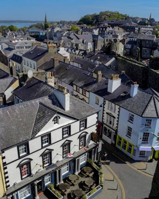
May 7 Portmadog to Camaes Bay through Caernarfon
Started our journey today on the narrow gauge train to Caernarfon, which takes 2-1/2 hours to go the 25 miles. The forecast had been for overcast, but the sun was out for most of the journey through Snowdonia Park. There are stops along the way that lead to hikes into the high country, including Snowdon Peak at 3560'. It's a very winding track and originally used the smaller engines, but to haul our good sized train, complete with first class carriage, kitchen car, open car, and about six third class cars, it required a special engine. The engines they use are articulated in three parts so they can bend with the curves. These were originally manufactured in the UK, but had to be "repatriated" from South Africa. The scenery was stunning, with lakes, streams, flowers and naturally, lots of sheep!
We had a little time in Caernarfon before continuing on to Bangor (emphasis on the last syllable), and the folks at the station kindly held our roller bags, so we checked out the castle (another of Edward I's), and in crossing the little harbor were treated to the swing bridge in action. There are also parts of the old city walls still remaining, and several old stone gates. The town has a lovely town square where they will be having a food festival this coming weekend. The castle is where the Princes of Wales have been crowned in recent years - a tradition started by Edward. Ironically, the original castle and town were intact for only 10 years before the Welsh attacked and destroyed them.
We also wandered up the hill to an old Roman encampment - the furthest west the Romans made it into Wales, and the largest Roman fort in North Wales. It is on the high ground and at one time held 1,000 soldiers in the fort, named Segontium. There are also the remains of Roman baths here, and we even found the main "drain" from the Roman plumbing with a little help from a local. A Roman road ran from here to Chester, which is now the route of the A55 highway.
We then had three buses to get to our B&B right on Camaes Bay on the north side of Anglesey Island. The tide was out when we arrived, but the sun was shining on the village, as viewed from the front of our cottage (a former doctor's surgery, built in 1904). It's completely charming and tastefully renovated inside. Tomorrow is supposed to be windy and rainy, but the views are superb.
0 notes
Photo
Caernarfon Castle is the main attraction, but the town itself has lots of charm and as much history. Its narrow streets welcome visitors to explore the beautiful corners and little shops... The Edward I’s royal castle and fortress was the center of a medieval walled town. Caernarfon also has remnants of Romans – 1000 years earlier they constructed their fort of Segontium on the hill above (its foundations still exist). —————————————— #caernarfoncastle #caernarfon #wales #visitwales #explore_wales #amazingplaces #bestofwales #amazingplacestovisit #photography #travelphotography #walestourism #wales❤️ #walesonline #europetravel #europetrip #ischuttsphotography (at Caernarfon) https://www.instagram.com/p/BwrUJ2nFKoW/?utm_source=ig_tumblr_share&igshid=l8ljk7j9nbwe
#caernarfoncastle#caernarfon#wales#visitwales#explore_wales#amazingplaces#bestofwales#amazingplacestovisit#photography#travelphotography#walestourism#wales❤️#walesonline#europetravel#europetrip#ischuttsphotography
0 notes
Text
History Revealed: The Welsh Highland Railway
by Annie Whitehead
A trip on the Welsh Highland Railway reveals more than just its own history; it allows the traveller to learn about centuries of Welsh history.
My historical research often takes me into the pages of the Welsh annals. It's true that the Mercians of the English Midlands often fought the Welsh, but it's also true that they allied themselves frequently to the Welsh princes to unite against a common enemy.
In the seventh century, Penda, (a pagan) and Cadwallon of Gwynedd (a Christian) banded together to wage war on Northumbria.
In the ninth century, Anarawd of Gwynedd gave fealty to Alfred the Great and Welsh troops allied with Alfred's son-in-law, Æthelred of Mercia, (husband of Æthelflæd, Lady of the Mercians) helping the English to defeat the Danes at Buttington in 893.
Ælfhere of Mercia, (whom I called Alvar) was also an ally of the Welsh. As earl of Mercia, his job was to defend the marches from incursions by the Welsh, but the chronicles often noted him aiding the Welsh in their internecine struggles. He aided Hywel ap Ieuaf against his uncle in 974 and again in 978.
It's not just my research that takes me into Wales, but my travels, too. And once in Wales, it's impossible to encounter only one period of history. The story of the land is everywhere, and you can see much of it from the railway.
Public Domain Image
The Ffestiniog Railway had already proved its worth in the nineteenth century in carrying people and goods through the mountain region of Snowdonia. In 1872 Charles Spooner proposed a new line linking the main railway at Dinas with Rhyd Ddu at the foot of Snowdon. It was only partially completed when it opened in 1881, and was only fully laid southwards through Beddgelert and the Aberglasyn Pass to Porthmadog in 1923. But, as I said, a trip on the railway reveals more than just the industrial past of Wales.
Embarking at Caernarfon, one cannot help but be awed, as the station stands in the looming shadow of the castle, built by Edward I (known as Longshanks) in 1283, and designed as a symbol of oppression, echoing the walls of Constantinople and reminding the Welsh that their princes were no more, and that Edward was now their lord and master.
Caernarfon Castle, photographed by my late father
But not far away we can see occupation of Caernarfon from an earlier time, at the Roman fort of Segontium. The Romans arrived in North Wales in 60AD, over a century after Caesar's first invasion. Their main objective was Ynys Mon (Anglesey) where they set about subduing the druids there. (See my earlier post.) In around 77AD Suetonius Paulinus established a fort at Caernarfon. It was named Segontium, and housed around 800 men. It was a base well-located for keeping control of both Ynys Mon and the Llyn Peninsular.

Roman soldiers murdering druids and burning their groves
on Anglesey, as described by Tacitus
The train journey takes you through the valley of the Afon Gwyrfai and through the village of Waunfawr. As it crosses the bridge over the Afon Gwyrfai it passes the old church at Betws Garmon.
Saint Garmon was a Gallican bishop who arrived in Britain in the latter half of the fifth century. He was best known for establishing schools and it it thought that Betws was one of these. Clearly the church is more modern, and has been rebuilt many times. In 1634 a small four-leafed clover was inscribed on the font in the rebuilt church, but no one knows for sure when the previous church had been built. Saint Garmon was also known as Germanus, and his mission was to combat the influence of Pelagius, who has been the study of a recent EHFA blog post by Kim Rendfeld.
The railway arrives at the foot of Snowdon and begins to climb. Somewhere around this area, JMW Turner must have sat for a while as he drew a pencil watercolour entitled Llyn Cwellyn.
Full citation for image at bottom of this LINK
Offering views back down the valley towards Llyn Cwellin and Mynydd Mawr (Great Mountain), the line curves sharply as the train heads towards Rhyd Ddu (Black Ford). Rhyd Ddu is believed at one time to have formed the pasture lands of Llewlyn Fawr (of whom more in a moment.) It remained a farming community until the middle of the nineteenth century when the slate quarries and copper mines caused the population to double in size. The village became home to a blacksmith and a postmaster, as well as a coal merchant, a dressmaker and a publican. This Welsh-speaking settlement also boasted three shops, a school, and a woollen mill. The downturn came in the latter part of the century, and these days there are no shops, although there is still a pub, and with the loss of the industry, the community makes its living from farming.
From the stop at Rhyd Ddu, the view is a choice between the looking up to the summit of Snowdon, or towards Beddgelert.
Mount Snowdon, or Yr Wyddfa, is the highest peak in Wales. Its name means 'burial place' and there is a legend attached to it. A cairn at the top of the mountain is said to mark the grave of Rhita Fawr, a giant who wore a cloak fashioned from the beards of all the kings he had killed.
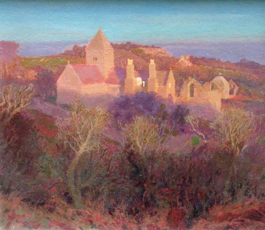
The mountain village of Beddgelert provides more insight into medieval Welsh history. The parish church of St Mary's was built on an earlier, sixth-century site, which eventually became the nucleus of an Augustinian priory in the thirteenth century. The priory was endowed by Llewelyn ap Iorwerth, also known as Llewelyn Fawr (Llewelyn the Great). He married the natural daughter of King John, and his grandson came to be known as Llewelyn the Last, fighting, and ultimately losing to, Longshanks. The priory prospered, and became an important centre. The building was destroyed by fire around 1283/4 and restored by Edward I. It is said that his munificent act was prompted by the fact that it was the carelessness of his own soldiers which had caused the fire in the first place. The later history of the priory is a familiar one, seeing it damaged again by fire in the early sixteenth century and then being allowed to fall into ruin on the orders of Henry VIII. Only the chapel was left standing.
St Mary's, Beddgelert - image attribution
Beddgelert is reputed to have been named after Gelert, the faithful hound of Llewelyn Fawr, who had a hunting lodge in the area, and it's possible to visit Gelert's 'grave'. The story goes that the faithful hound was left to guard the prince's baby, only to be discovered with bloodied mouth and the baby missing. Llewelyn drew his sword and killed the dog, whose yelp caused the baby to cry out. Seemingly, the dog had in fact protected the baby from a wolf. Full of remorse, Llewelyn buried the dog with great ceremony.

Gelert by Charles Burton Barber - Public Domain Image
Travelling on from Beddgelert the train crosses the Afon Glaslyn and along the Aberglasyn Pass. It then goes through the Aberglasyn tunnels. Between these tunnels, at Plas-y-Nant, the story of Wales is brought nearer to modern times, with the location of circular gun mounting blocks, built for World War II 'Blacker' Bombards, 20lb anti-tank mortars. There is also a pill box dating from around 1940.
Since I first travelled on the railway, the line has been opened up further and a team of enthusiasts works hard to keep the engines running.
Wherever I go in North Wales, I encounter history spanning the centuries. Here on the little mountain railway, the same is true. With monuments, sites and buildings stretching from Roman times to WWII, it really is the tale of centuries, incorporating a wonderful mix of fact and legend.
~~~~~~~~~~

Annie Whitehead is an author and historian, and a member of the Royal Historical Society. Her first two novels are set in tenth-century Mercia, chronicling the lives of Æthelflæd, Lady of the Mercians, who ruled a country in all but name, and Earl Alvar who served King Edgar and his son Æthelred the Unready who were both embroiled in murderous scandals. Her third novel, also set in Mercia, tells the story of seventh-century King Penda and his feud with the Northumbrian kings. She is currently working on a history of Mercia for Amberley Publishing, to be released in 2018.
Amazon Page
Website
Blog
Hat Tip To: English Historical Fiction Authors
0 notes
Photo


“I thought to have seen a Town and a Castle, or a Castle and a Town, but I saw both to be one, and one to be both; for indeed a man can hardly divide them in judgement or apprehension; and I have seen many gallant fabrics and fortifications, but for compactness and completeness of Caernarvon, I never yet saw a parallel. And it is by Art and Nature so fitted and seated, that it stands impregnable,and if it be well manned, victualled and ammunitioned, it is invincible, except fraud or famine do assault or conspire against it”. John Taylor, 1652.
At Caernarvon Castle, where the present foundation was built in 1283 at the behest of Edward I of England but which had been a fortified site for centuries (the Romans had built their fort of Segontium nearby), held by Welsh princes in uneasy coexistence with Anglo-Norman kings who deemed themselves overlords, until Llywellyn ap Gruffudd (after “rebelling” as Edward called it) was defeated and killed by Edward’s forces in 1282 and the next year, the present building was begun, engineered by James of St George and believed to be inspired by what Edward saw on crusade in the 1270s. It was finally completed in 1330.
Despite having taken the Welsh lands by force, and having to fight of rebellions (the castle and town were captured and burned by rebels in 1294-5, barely a decade after building!) Edward was keen to stress himself as a legitimate ruler and borrowed on the legends of Macsen Wledig to do so. George Borrow, whose Wild Wales is essential reading and accompanied me throughout my trip, wrote of a custom which began with Edward having his wife Eleanor moved to Caernarvon to give birth to the future Edward II.
“This castle was built by Edward the First after the fall of his brave adversary Llewelyn, and in it was born his son Edward whom, when an infant, he induced the Welsh chieftains to accept as their prince without seeing, by saying that the person whom he proposed to be their sovereign was one who was not only born in Wales, but who could not speak a word of the English language”!
This became propagated as a legend by Anglo-Norman kings to stake their claims to be rightful rulers, which didn’t stop legendary rebel Owen Glendower from beseiging it twice in 1403 and 1404, though he failed in this.
Later, the castle fell into decline as under the Tudor monarchy the forceful subjugation of Wales was deemed not to be necessary, but was still a formidable site, as Taylor reported. In the Civil Wars it was a royalist stronghold held by Lord John Byron, who we last met being defeated at Nantwich, but was surrendered in 1646.
Mercifully, Parliamentarian plans to demolish the castle were never carried out, and later the site inspired artists such as (1) JMW Turner (1836). The coming of the railway in 1852 opened up the slate industry and tourism and began Caernarvon’s entry into the modern age, with great work being done on restoration by mayor and deputy constable Llewellyn Turner.
With local hero Lloyd George being made Chancellor of the Exchequer, the tradition of investiture begun by Edward I was revived with another Edward, the future Edward VIII, (6) being invested in 1911. The present prince of Wales was (7) invested in 1969.
Not only has the world come to Caernarvon, Caernarvon and has also gone out to the world, as you’ll find at the museum within the castle grounds which pays tribute to the achievements of the Royal Welch Fusiliers, who have proudly served in various incarnations since 1689 and are still on duty.
After being passed into the care of CADW in 1984 things have settled down a bit and the castle, now a world heritage site, is a tribute to the skills of Edward’s engineer James of Saint George. Despite its turbulent past it now rests as a gateway to (10) the Wales Coastal Path which as we’ll see leads on and on and on...
1 note
·
View note
Text
Pilot major project ideas
For my pilot major project, I have decided that I want to create a body of work that will be based around North Wales, where I have lived all my life before moving to London to continue my studies. From spending time away from North Wales, it has given me the opportunity to realise and appreciate what I have moved away from and how lucky I am to call it my home. I also feel by creating a body of work about my area will be quite unique for people to see in the city, which will be highly beneficial for my pilot major project and quite possibly for my final major project next year. I want to find a project that has a lot of cultural issues either previously or currently.
As Wales is highly known for its beautiful landscape and its industrial history of many quarries and various factories, I want to explore this as my area of interest. The ideas I currently have that surround the industrial history are:
The slate industry of North Wales
The Ferodo Factory
The slate industry of North Wales
The existence of the slate industry in Wales has existed since the Roman period, when slate was used to roof the fort at Segontium, now known as Caernarfon located on the edge of the Menai Straits. The slate industry grew slowly until the early 18th century, then expanded rapidly until the late 19th century, at which time the most important slate producing areas were in Northwest Wales, including the Penrhyn Quarry near Bethesda, the Dinorwig Quarry near Llanberis, the Nantlle Valley quarries, and Blaenau Ffestiniog, where the slate was mined rather than quarried. Penrhyn and Dinorwig were the two largest slate quarries in the world, and the Oakeley mine at Blaenau Ffestiniog was the largest slate mine in the world. These quarries all surround where I have lived and grew up all my life.
The Penrhyn Quarry is still producing slate to this day, though at a much reduced capacity from its heyday at the end of the 19th century. In 1995, it accounted for almost 50% of UK production. It is currently owned and operated by Welsh Slate Ltd (a subsidiary of Lagan Building Solutions), which also owns and carries out some operations at the Oakeley quarry at Blaenau Ffestiniog, the Pen yr Orsedd quarry in the Nantlle Vale, and the Cwt-y-Bugail quarry.
The Welsh slate industry was essentially a Welsh-speaking industry. Most of the workforce in the main slate-producing areas of North Wales were drawn from the local area, with little immigration from outside Wales. The industry had a considerable influence on the culture of the area and on that of Wales as a whole. The caban, the cabin where the quarrymen gathered for their lunch break, was often the scene of wide-ranging discussions, which were often formally minuted. A surviving set of minutes from a caban at the Llechwedd mine at Blaenau Ffestiniog for 1908–10 records discussions on Church Disestablishment, tariff reform and other political topics.
Most of the workings and equipment in the quarries such as the slate trucks and pulleys across the landscape have now fallen into disrepair as when work ceased it was left in situ, which has resulted in nature slowly reclaiming back the land. Some of the quarry locations have now been re-used and turned into tourist attractions such as Dinorwig quarry where it is now within Padarn Country Park where the Slate Museum is located in Llanberis.
Due to the beautiful landscape and large amount of history it holds, North Wales heavily relies on tourism as a vital source of income. Even though Penrhyn quarry is still in use, one part of the quarry has been turned into a very popular tourist attraction known as Zipworld. It is the fastest zip line in the world and the longest in Europe. The zip line, known as Big Zipper takes you over the quarry lake often reaching speeds well in excess of 100mph. These attractions bring thousands of people every month to the local area to take part and to learn about the strong history of the location. Another part of Dinorwig quarry houses the Dinorwig power station in caverns under the old quarry workings. This is a hydro-electric scheme where water is stored at a high altitude in a resivoir located at the top of Marchlyn Mawr mountain. This is discharged into Llyn Peris through the turbines during times of peak electricity demand. It is pumped back from Llyn Peris to Marchlyn Mawr during off-peak times. The production of electricity is then distributed to the local area
As my project, I would like to document how these quarries currently stand in their form which will show the dilapidated state of the old quarry houses and existing equipment and show how nature is slowly reclaiming back the land from its rich history. I would also like to explore how important these tourist attractions that have been created from using the quarries bring income not only to their businesses, but also to the area. As I mentioned tourism, I could photograph these areas and also the tourist to create series of portraits that have come to visit from all over the world. This could include asking them a few questions about where they are from, what brought them to this area and what they think now they are actually here. I feel if I followed this idea, I would need to break it down into sub-ideas to give me and also the viewers a clear indication which route I am following and the true purpose.
The Ferodo Factory
The Ferodo Factory is an abandoned and dilapidated factory that is located on the banks of the Menai Straits, near Caernarfon. Ferodo was one a state of the art plant that manufactured brake parts and clutches for the motor vehicle industry. After the closure of the quarries across north Wales with thousands of people becoming unemployed, Ferodo offered work to the ex-workers. After the construction of the site for several years, it was opened in 1962 by Princess Margaret, where it employed 1100 people. Over the years the workforce gradually became smaller where in 1997 it was bought and renamed to Friction Dynamics by American businessman Craig Smith where it employed 220 people. Problems started to occur soon after when Transport and General Workers Union (T&G) complained over unfair pay and work conditions. 86 workers went on strike which resulted in Smith sacking these workers and caused fury for not only the workers, but the whole surrounding area and community.
A court tribunal was held in 2002, where workers were found to be unfairly dismissed. Smith reacted to this and called in the administrators in 2003. Within three weeks, Smith decided to re-start up the factory and renamed it to Dynamex Friction. This caused even more anger and fury for all the local area where many protest marches occurred. This resulted in (T&G) holding a picket at the gates for two and a half years. A second tribunal was held where it was found that Friction Dynamics and Dynamex Friction were the same company and resulted in the site being sold in 2004 and finally closed its doors in 2008. It is recorded to be one of the longest industrial disputes to date. Over the last few years, there has been various talks of using the land for various uses including a multi-million pound digital centre and a state-of-the-art prison, but due the large amount of asbestos inside the site and that has been buried in the surrounding grounds over the years, many have been put off by the hefty estimate of £20-30million pounds just to clear the site safely and correctly. Since closing in 2004, it has stood empty ever since, and has lead to several arson attacks over the years.
As this was a major industrial plant in North Wales and for the local area I live in, my interest has grown in the current dilapidated state of the building in a way that achoes its recent history of industrial dispute and failure. My plan is to document how the site currently stands and capture how nature, vandalism and short-term illegal occupancy has changed the character of the abandoned site.
I am also hoping to contact ex-workers of the site that still live in the local area to see if they would be interested in taking part of my project by allowing me to photograph them to create a series of portraits, and ask them a brief description about their roles at Ferodo and any memories both good or bad they are willing to share.
I feel whichever idea I decide to follow will be both as appealing to each other due to their industrial history and disputes over the years. I also feel the body of work will stand out in London as it is something different to what most in the City see and also because of my relationship with North Wales will allow me to commit and put all my attention to it rather than following a project based on London which I wouldn’t be totally happy and driven about.
Over the next few weeks, I will consider these options and decide which would be best to follow as I will need a clear direction and enough time to give myself to travel back and forth to North Wales on the weekends to capture these photographs.
0 notes
Text
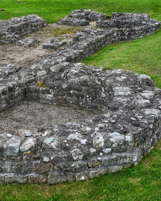


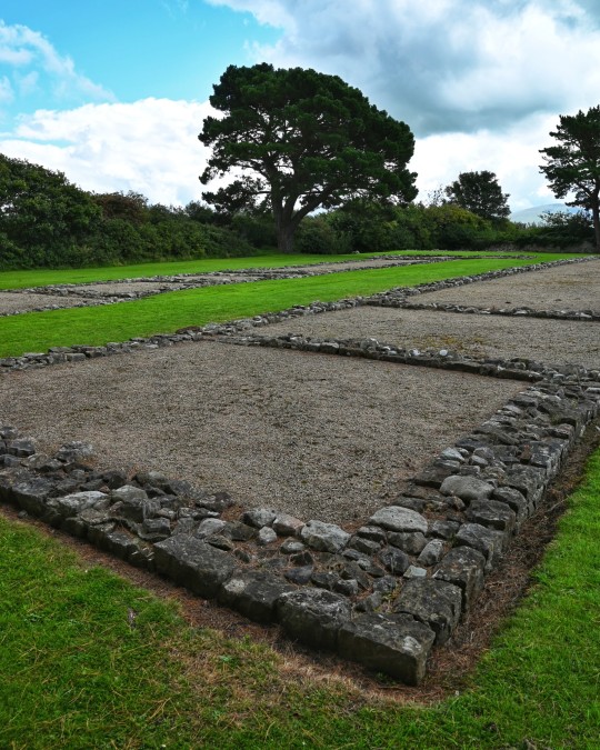

Segontium Roman Fort, Caernarfon, Wales
#roman#roman army#roman living#romans#roman building#roman fort#archaeology#roman ruins#wales#Caernarfon#bath house#gate house#barracks#roman empire#ancient cultures
155 notes
·
View notes
Photo


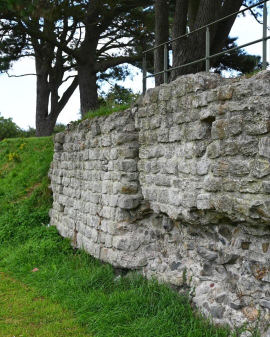
Rhes Segontium, Caernarfon.
0 notes
Last Seen Blogs