#southeast mexico
Text
Asian slaves, indigenous Americans, and identity in colonial era Mexico
The Spanish Philippines had a diverse slave population for local labor and export, including Filipino Indians [i.e. natives; indios], Muslim war captives (moros), and foreign slaves from as far away as Portuguese India.
… Upon their arrival, chino slaves [i.e. any Asian slave, not just Chinese] were absorbed by the urban economy of Mexico City, where they mainly worked as domestic servants or in textile mills (obrajes) … For their part, working in the city provided chinos with some possibilities for manumission. Chinos in domestic service were especially apt to embrace the limited opportunities available to them and to experience some social mobility. In the obrajes, chinos had few of the freedoms given to domestic servants, but they did benefit from government oversight of the industry. During official visits, chino slaves appealed for protection from overt exploitation by claiming that they were Indians (even if they were from Portuguese India). Remarkably, visiting inspectors listened to their complaints, and they often responded by liberating individual chinos under the assumption that they were indeed native vassals and could thus not be held in bondage. The overall experience of chinos in the viceroyal capital confirms the benefits of living close to the center of colonial power.
The presence of free indigenous immigrants from the Spanish Philippines in Mexico reinforced the idea that all chinos were Indians. The complex governing structure of colonial Mexico involved two republics or political communities (the república de indios and the república de españoles); this organization separated the indigenous majority from everyone else to facilitate the collection of tribute and the ministry of the Catholic Church … [N]ative immigrants from the Philippines purposely sought to confirm their membership in the Republic because corporate status provided personal advantages. They asked to be tallied in tribute rolls in Mexico to benefit from concomitant privileges, such as trading rights and legal representation through the General Indian Court. At the same time, free Filipinos were frequently confused with chino slaves - a situation that had serious consequences for Filipinos' relations with colonial institutions and enslaved individuals. Some immigrants resented having their indigenous identity questioned and sought to maintain a sense of their Indian-ness by keeping their distance from chino slaves. The majority, however, expressed solidarity with chino slaves. Filipino artisans, for example, took on chino slaves as apprentices and taught them marketable skills. Similarly, Filipino traders incorporated chinos into their own credit networks to facilitate self-purchase.
Individual chinos who were manumitted also embraced an Indian identity, regardless of whether they were from Goa, Macau, or other places in South and Southeast Asia. In this way, chinos challenged official attempts to define them solely as former slaves. Instead, they sought to join the free republic. The possibility for this kind of social integration caused widespread concern among slave owners. To defend their property rights, masters started to brand chino slaves on the face, rather than on the chest or arm as they did with Africans, in order to dissuade them from fleeing and "passing" as free Indians. This horrifying development shows that Indian communities welcomed runaway chino slaves and, by extension, that slave owners sought visible markers of their slaves' status.
Excerpt from the Introduction to “Asian Slaves in Colonial Mexico: From Chinos to Indians” (2014) by Tatiana Seijas
114 notes
·
View notes
Text
trying to arrange to get my phone mailed back to me when i do not have a phone is. nightmare.
#.txt#i have to somehow provide them with a box when they r in mexico and i am in the southeast us#because for some reason they dont have that so EYE have to do it#and i have to fill out a shipping label and everything by myself for dhl#which requires me to put in how much the package weighs. which i DON'T KNOW!!!#because I DON'T KNOW HOW TO GET THEM THE PACKAGE!!!!!#dude im about to explode fr i hate it hereeeee#and i don't even have a phone to call them. bro this is agonizingggg
5 notes
·
View notes
Video

flickr
Rubber Rabbitbrush and Other Wildflowers at the Cedar Tree Tower (Mesa Verde National Park) by Mark Stevens
Via Flickr:
A setting looking to the west while taking in views across a field of rubber rabbitbrush wildflowers present around the Cedar Tree Tower in Mesa Verde National Park. My thought on composing this image was to use the LiveView LCD screen on my Nikon D850 SLR camera. I wanted to have the wildflowers all around me, but to include a depth in having them extend off the image edges. I felt that using the LiveView screen would allow me to hold the camera for that view but not have me disturb the wildflowers by getting in them using the optical viewfinder.
#Ancestral Puebloan#Ancestral Puebloan Archaeological Sites#Archaeological Preserve#Archaeological Sites#Azimuth 289#Blue Skies#Blues Skies with Clouds#Cedar Tree Tower#Colorado Plateau#Day 6#DxO PhotoLab 7 Edited#Ericameria nauseosa#Intermountain West#Landscape#Landscape - Scenery#Looking West#Mesa Verde National Park#Nature#New Mexico and Mesa Verde National Park#Nikon D850#No People#Outside#Partly Sunny#Portfolio#Project365#Rocky Mountains#Rubber Rabbitbrush#Scenics - Nature#SnapBridge#Southeast Colorado Plateau
2 notes
·
View notes
Text

the caterpillars of the Titula meterythra moth and the Rothschildia erycina moth can vomit potentially irritating substances to deter predators
#mo talks#theres probably more moth species who do that but those are the two that were within a 4 page span from each other shdhdhdj#(in my moth book i should ad. their habitats do not overlap at all.)#the r. erycina lives in southern mexico/brazil and the t. meterythra in southeast asia#theyre both really beautiful as moths tho! bc theyre tropical moths!
2 notes
·
View notes
Text


Pics of my vacation, I really love in this area of Mexico despite its heat
#I'm in the southeast coast of Mexico btw#Since my dad is working here we choose to visit him#My Pics#México#Mexico#.:Odi blabs it all:.
2 notes
·
View notes
Text
I love doing this route, I wish I could do it more often. I love the people and the sights.


#delivery#delivery drivers#dirt road#driving#profesional driver#usps#fedex#ups#driver#middle of nowhere#southwest ranches#southeast ranches#new mexico#mountains#wildlife#antelope#old building#historic#scenery#photography#work blogging#my blog#blog#my diary#my daily life#my photos#abandoned buildings#rural#small town#package handler
2 notes
·
View notes
Text
Surprise! These Budget-Friendly Destinations Charmed Us in Retirement
Retirement is the golden ticket to finally embark on those dream travel adventures you’ve been putting off for years. But let’s be real, after decades of saving for retirement, blowing it all on a single trip isn’t exactly ideal. Jeff and I are firm believers in budget slow travel, and we’ve been pleasantly surprised by the affordability and charm of several unexpected destinations.
Mexico: Our…
#affordable destinations#Albania#budget travel#Eastern Europe#Georgia#hidden gems#Laos#Mazatlán#mexico#Montenegro#retirement travel#Southeast Asia#Vietnam
0 notes
Text
When I said I was going to New Mexico this August, 99% of people looked at me and asked where in Mexico I was going to be traveling to. What many people don’t realize is that New Mexico is indeed part of the United States. It’s also known as the Land of Enchantment for a reason. In this blog I’m going to show you several reasons why you need to visit New Mexico right now.
#Why New Mexico Is The Most Underrated State#backpacking southeast asia#backpacking guide for beginners#world travel guide#adventure travel blogs#destination guide santa maria valley#destination guide carmel#best travel blogs#europe travel blog#california adventure tips#female travel bloggers#thailand travel guide#preethi chandrasekhar#travel
0 notes
Text
LOTD: Veracruz Southeast Breakwater
~sorry for delay - meant for April 22nd, 2023~
(from: http://www.ibiblio.org/lighthouse/mxg.htm)
Veracruz Southeast Breakwater ("Faro Verde")
Date unknown. Active; focal plane 10 m (33 ft); green flash every 5 s. 7 m (23 ft) octagonal pyramidal concrete tower, painted green. Ricardo Rosas also has a 2018 photo, Trabas has Capt. Peter's closeup photo, Natanael Velázquez Pastrana has a 2022 photo, the light is on the left in a photo on Lightphotos.net, Mikuel Ramos has a closeup street view, and Google has a satellite view. Known locally as the Faro Verde (Green Lighthouse). Located at the end of the breakwater on the southeast side of the harbor. Accessible by walking the pier. Site open, tower closed. CF-30-305; Admiralty J4282; NGA 15388.

(full photo found here; ©Ricardo Rosas)
0 notes
Text
In place of blanks on the map, we’re now able to see highly cultivated landscapes with massive infrastructure stretching back to the early centuries BCE. Road networks, terraces, ceremonial earthworks, planned residential neighbourhoods, and regional settlement systems ordered into patterns of geometrical precision can be traced across Amazonia, from Brazil to Bolivia, as far as the eastern foothills of the Andes. In certain parts of Amazonia, the forest itself turns out to be a product of past human interaction with the soil. Over time, this generated the rich ‘anthropogenic’ earths called terra preta de índio (‘black earth of the Indians’), with levels of fertility far in excess of ordinary tropical soils. Scientists now believe that between 10,000 and 20,000 large-scale sites remain to be discovered across Amazonia. Similarly startling finds are emerging from Southeast Asia, and we might reasonably expect them from the forested parts of the African continent too.
Of course, the same procedures are changing our picture of tropical landscapes that did witness the rise and fall of great kingdoms, and even empires. Archaeologists now believe that in the year 500 CE, between 10 and 15 million people lived in the Maya lowlands of Yucatán and northern Guatemala. For comparison, the Atlas offers a figure of just 2 million for all of Mexico in the same era, including the Indigenous cities of the Altiplano (at least some of which, we now know, were organised not as empires or even kingdoms, but fiercely autonomous republics, long before the Spanish conquest).
It is easy, encouraged by works such as the Atlas, to imagine ancient history as a chequerboard of kingdoms and empires. But it is also very misleading. Ancient polities in the Maya lowlands and Southeast Asia had porous boundaries, constantly shifting, and open to contestation. Authority waned with distance from the centre. Warfare and tribute were largely seasonal affairs, after which coercive power shrank back behind the walls of the capital. As the archaeologist Monica Smith points out, only the most naive historian would assume that the claims inscribed on imperial monuments are a simple reflection of political reality on the ground. Of course ancient rulers loved to present themselves as ‘sovereigns of the four quarters’, ‘masters of the known world’, and so on. Yet no ancient world emperor could even have imagined powers of surveillance, such as those now enjoyed by any minor dictator or oligarch.
On a global scale, we are witnessing a revolution in our understanding of ancient demography. To ignore it, these days, is to indulge in a cruel sort of intellectual prank, by which the genocide of Indigenous populations – a direct consequence of the planetary revolt against freedom, in the past 500 years – is naturalised as a perennial absence of people. Nor can we just assume that if we want to understand the prospects for our modern world, the only ‘big’ stories worth telling are those of empire.
5 July 2024
350 notes
·
View notes
Text
The United States should go back to having thirteen states
On the basis that the 13-star flag was the best version, and that 50 is just too many dang states, I present my proposal for a 13-state United States of America. State names are placeholders only; presumably the inhabitants of these states would want to name them something different.
State boundaries are intended to attempt to respect both geographical features and approximate internal cultural borders of the United States, keeping contiguous regional cultures more or less grouped (e.g., the Ozarks are mostly within Texas-Louisiana; all of New England is in the Northeast; the Piedmont region is entirely within the Mid-Atlantic state, etc.). I have also tried to reduce the insane population disparity between states as much as was reasonable; but since the three non-contiguous states, Alaska, Hawaii, and Puerto Rico, are necessarily culturally and geographically distinct, they are kept as separate states. Also since they're each individual states with their present borders, I was lazy and only drew the 10 contiguous states.
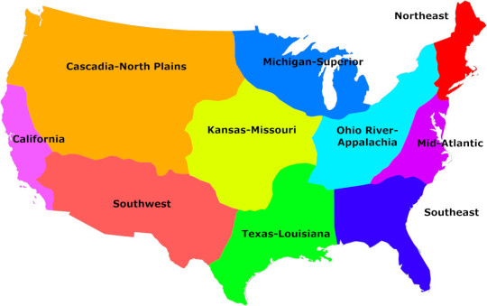
The thirteen states are:
Northeast: About 34 million inhabitants. Capital: Boston; House delegation: 42 members; Senators: 10; EC votes: 52
Mid-Atlantic: About 41 million inhabitants. Capital: Richmond; House delegation: 51 members; Senators: 12; EC votes: 63. Contains the national capital (Washington-D.C.)
Ohio River-Appalachia: About 39 million inhabitants. Capital: Wheeling; House delegation: 48; Senators: 12; EC votes: 60
Southeast: About 44 million inhabitants. Capital: Jacksonville; House delegation: 54; Senators: 12; EC votes: 66
Michigan-Superior: About 37 million inhabitants. Capital: Green Bay; House delegation: 46; Senators: 10; EC votes: 56
Kansas-Missouri: About 24 million inhabitants. Capital: Kansas City; House delegation: 30; Senators: 6; EC votes: 36
Texas-Louisiana: About 40 million inhabitants. Capital: Shreveport; House delegation: 50; Senators: 12; EC votes; 62
Cascadia-North Plains: About 26 million inhabitants. Capital: Idaho Falls; House delegation: 32; Senators: 8; EC votes: 40
California: About 41 million inhabitants. Capital: Sacramento; House delegation: 51 members; Senators: 12; EC votes: 63
Arizona-New Mexico: About 19 million inhabitants; Capital: Albequerque; House delegation: 24; Senators: 6; EC votes: 30
Alaska: About 730,000 inhabitants. House members: 1; Senators: 1; EC votes: 3
Hawaii: About 1.4 million inhabitants. House delegation: 2; Senators: 1; EC votes: 3
Puerto Rico: About 3 million inhabitants. House delegation: 4; Senators: 1; EC votes: 5.
Total House size is 435, total Senate size is 103, and the total number of EC votes is still 538.
(Obviously in principle I would support abolishing both the Senate and the Electoral College, but if for some reason you were going to keep them, I think at minimum you would have to reform the whole "one state, two senators" rule, ergo I have gone for a form of proportionality here, although not so proportional as House delegations.)
102 notes
·
View notes
Video

flickr
Petroglyph at the Pipe Shrine House (Mesa Verde National Park) by Mark Stevens
Via Flickr:
While taking in views around the Far View Sites with the Pipe Shrine House. The setting is looking to the north-northwest at a nearby wall with a spiral pattern edged into stone and then a look beyond to other parts of this Ancestral Puebloan archaeological site. The other thing that drew me into this image was the layers present, which I attempted to emphasize by capturing a look above a nearby wall to other walls in the distance.
#Ancestral Puebloan#Ancestral Puebloan Archaeological Sites#Archaeological Preserve#Archaeological Sites#Azimuth 341#Blue Skies#Blues Skies with Clouds#Colorado Plateau#Day 5#DxO PhotoLab 7 Edited#Far View Sites#Intermountain West#Landscape#Landscape - Scenery#Looking NNW#Mesa Verde National Park#Nature#New Mexico and Mesa Verde National Park#Nikon D850#No People#Outside#Partly Cloudy#Partly Sunny#Petroglyph#Pipe Shrine House#Project365#Rocky Mountains#Scenics - Nature#SnapBridge#Southeast Colorado Plateau
2 notes
·
View notes
Text
The groupings are not based on trying to ensure equal demographics in each, but by proximity to and impact of the Bering Strait Land Bridge theory or other relation to prehistoric colonization of the Americas.
I wasn't sure how to group Oceania and the Polynesian/Micronesian/Melanesian folks given the overall histories, so you get your own bunch. I can't remember if those theories about Polynesians reaching the Americas for trade on occasion, prior to written records, are legitimate/supported or just a thing I heard once. Either way, I think that history of 'discovering unpopulated lands by heading east from large landmasses' is similar enough that maybe it comes up for overlapping histories? IDK! You get your own buttons.
Also wasn't sure if it would make sense to include SEAsia with East Asia or lump it in with the rest, buuuut I think upon reviewing the maps that it looks like the Strait is a lot less geographically/politically related to most of East Asia than I thought, so there's less of a difference between EAsia and SEAsia than I thought, enough that marking them out separately from Russia but not each other probably works.
I initially wrote out a less America-Specific description of primary/secondary or elementary/middle/high but honestly? It took up too much space. Appropriate disambiguation made the title so long that people wouldn't have read it. So. You get K-12 or equivalent.
I'm including Mexico with Central America for two reasons:
1. Most Mexicans I've seen talking on the topic recently, at least on tumblr, prefer to be divided in that direction for cultural reasons.
2. Geographically much more distant from the Bering Strait than its northern neighbors.
Also, please reblog! I want this to go past my primarily anglophone-countries circle if possible.
#education#bering strait#bering strait land bridge#united states#canada#history#prehistory#phoenix polls#school
142 notes
·
View notes
Text
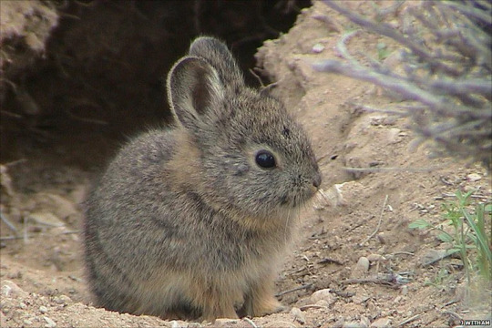
The Volcano Rabbit (Romerolagus Diazi), also known as Teporingo or Zacatuche, is the second-smallest rabbit in the world at 390 to 600 grams. It is native to four volcanoes just southeast of Mexico City & emits very high-pitched sounds to warn other rabbits of danger.
723 notes
·
View notes
Text
Had to go and get two tires replaced this morning.

Hopefully it didn’t set me back too far on my delivery times, but at least the tire place we go to has this cool windmill on the wall.

#delivery#delivery drivers#dirt road#profesional driver#driving#usps#ups#fedex#driver#middle of nowhere#photography#my photos#work blogging#blog#my blog#my diary#my daily life#windmill#new mexico#southeast ranches#southwest ranches#decoration#decor#let’s get this bread
1 note
·
View note
Text

Colorado, United States: Colorado is a landlocked state in the Mountain West subregion of the Western United States. Colorado borders Wyoming to the north, Nebraska to the northeast, Kansas to the east, Oklahoma to the southeast, New Mexico to the south, Utah to the west, and meets Arizona to the southwest at the Four Corners. Colorado is noted for its landscape of mountains, forests, high plains, mesas, canyons, plateaus, rivers, and desert lands. Wikipedia
69 notes
·
View notes
Last Seen Blogs

fallaciousfeline
Pastel Goth Mermaid

alexsassyturner
Mr. Sass from Sheffield

tunapotatobangchan
Untitled

infamous-walrus
Drop the Throne

subliminalscar
s c a r