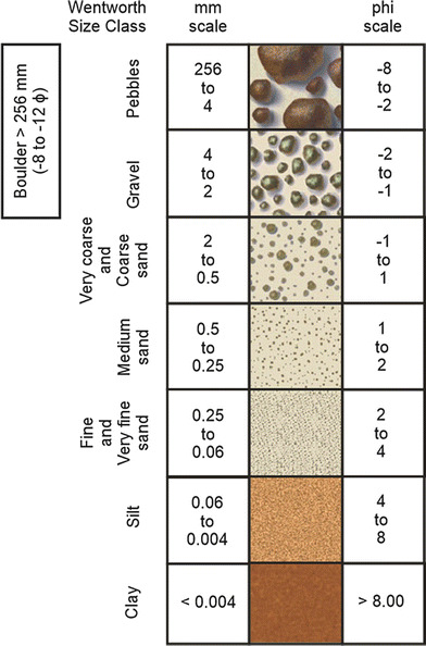
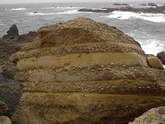
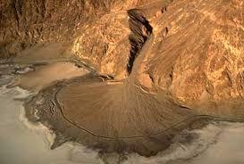
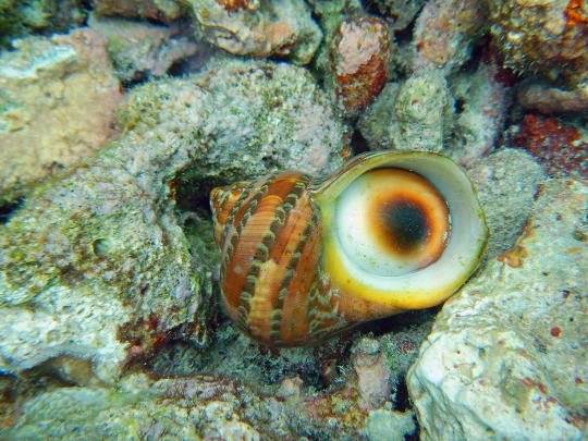
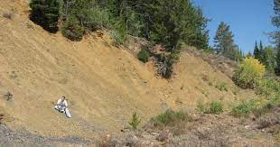
#turbidites
Photo
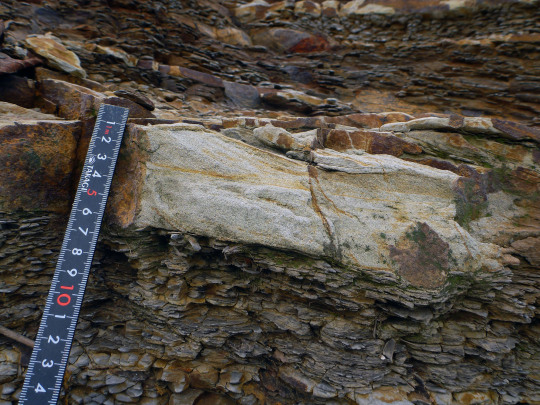
Deep marine sandstone of a Miocene age, showing the Bouma Sequence. 砂岩
#nature#sceince#geology#sandstone#sedimentary geology#deep marine#turbidite#mass flow#turbidity current#gravity flow#cenozoic#miocene#niigata#japan#original photography on tumblr#original photographers
54 notes
·
View notes
Text

Redrew my Zorasona, Pebbles!
I see a lot of people saying that Yona’s domain may be a coral reef environment, and I think it would suit Pebbles to be from there as well! She’s a Geologist, and her tentacles (which reach her tailbone) are all functional as individual arms- which is perfect for holding for rocks and tools! I like to think she’s my normal height of 5’2, because octopi can shrink down to squeeze through small cracks. I imagine her small stature would help her hide in the reefs or squeeze around in underwater caves to find the things she’s looking for. I could imagine maybe she has that octopus ability to camouflage ever so slightly.
Perhaps she came to Zora’s Domain with Yona and her entourage. She was definitely convinced because “oooh active continental margin…. subduction zone with resulting volcanic arc ooooh” like any geologist would be. Take a break from the M.O.R.B’s and turbidites, Pebbles. After all, Ledo and Fronk could use some help locating and mining luminous stones.
She also definitely has a thing for guards- wink wink. (But who wouldn’t). And maybe Ledo-
I guess other factors would be she’s a young adult (early 20’s for a Zora), and she’s a biromantic asexual. She’s also afraid of the deep open ocean, the only thing keeping her going down there is the hunt for pillow basalts.
#I would draw more but my time in uni is limited#but here she is!#botw#botw zora#totk Zora#zorasona#tears of the kingdom
40 notes
·
View notes
Text
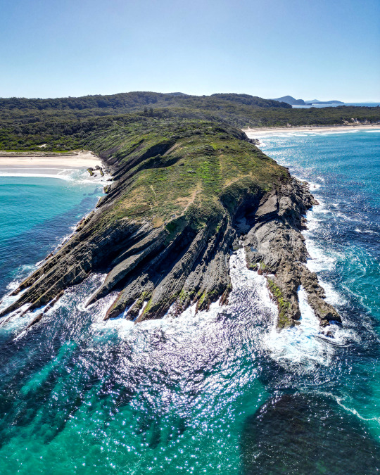

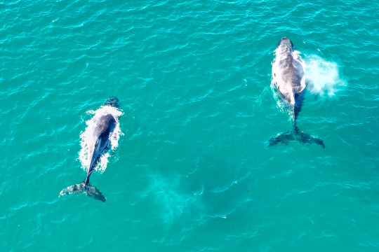
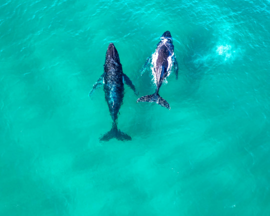
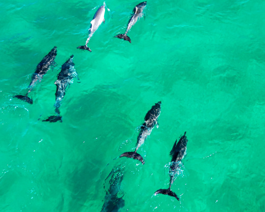
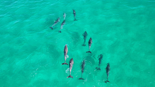
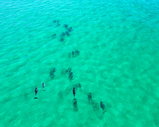
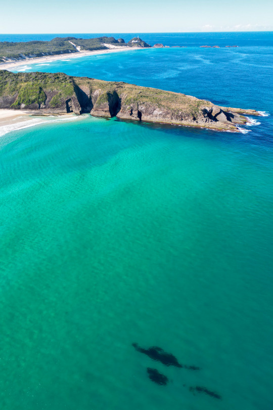
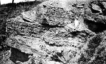
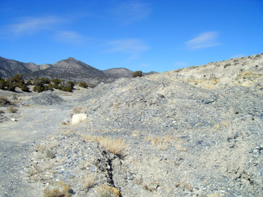
2023: The annual trip up to Treachery Headland this year gave us precious little surf but we had the most glorious weather to observe all the many, many cetaceans. The drone facilitated a great shot showing the folded Carboniferous turbidites making up the headland.
#australia#new south wales#sealrocks#treachery headland#humpback whale#Indo-Pacific bottlenose dolphin#Mavic mini 3 pro
62 notes
·
View notes
Text
Wordplay Wednesday: Conglomerate
What is a conglomerate? It is a type of sedimentary rock that is characterized by it's rounded gravel, pebble, or cobble-sized grains cemented together by silica, calcite, or iron oxide.
There are many ways in which a conglomerate can be formed. Turbidites are deep marine conglomerates created by turbidity currents.
Many are fluvial in nature and occur in rivers with a high flow rate (immature river systems) such as the Buckhorn Conglomerate of the Cedar Mountain Formation in Utah, USA.
Alluvial fans along mountain fronts tend to make the thickest conglomerates. These are often called fanglomerates.
Debris flows also deposit conglomerates such as the Clarno Formation in John Day National Monument which was deposited by a lahar or volcanic mudslide.
Glaciers create tillites, a very poorly sorted type of conglomerate (no discernable pattern to size or shape of grains).
#geology#fun facts#rock formations#stratigraphy#conglomerate#John Day Fossil Beds#national monument#cedar mountain formation#lahar#volcano#river channel
18 notes
·
View notes
Text
The Great ACT-NSW-NZ Trip, 2023-2024 -Te Upoko-o-te-Ika-a-Māui
The Head of Māui's Fish - specifically, the area around New Zealand's capital city, Wellington, deriving from the legend of the fishing up of the island by the demi-god Māui. The harbour is the mouth - an area of reddish-purple rock facing onto Cook Strait was the bait Māui used.


Wellington's placement makes it one of the windiest cities in the world, and the narrow strait and howling gales makes for complicated tides and a shocking number of shipwrecks. The geology makes for some fun times too - the Haowhenua (Māori for 'land swallower') earthquake around 1460 AD raised the harbour area by 6 meters, turning some islands into the Miramar Peninsula. The 1855 Wairarapa earthquake moved a 150km stretch of the Wairarapa fault 20m along and 8m up. in some respects this was convinient timing, since the city had been desperately short of flat land at the time, and now part of the harbour wasn't harbour anymore. It's now the central business district of the city.
Every public building in New Zealand we went into had a warning plaque that the building was earthquake prone - one of the museums in wellington had that, BUT also suggested, if the quake was a particularly big one, you might want to head to the top floor rather than out into the street. Because Wellington is also tsunami prone. The 1855 quake produced one that reached 11m above sealevel.
The hills are also festooned with delightfully eccentric architecture, and more than a few funicular lifts so people can actually get to their homes from street level. One person had a funicular installed because their dog was getting elderly and struggled with the stairs.
Most of the species I saw were along the shoreline - at the harbour and ferry terminal in the city, out around the edges of the Miramar Peninsula, and out on Cook Strait at Pariwhero/Red Rocks.
The geology at Pariwhero is quite interesting - much of the basement rock in New Zealand is greywacke, a dark sandstone derived from turbidite deposits acculmulated at the edge of the Australian tectonic plate. At Pariwhero there are also deposits of argillite, a finer-grained rock quite useful for stone tools. And basalt - but the volcanic rocks are 50 million years older than the greywacke and argillite surrounding them. That's because the basalt was originally a set of seamounts - underwater volcanoes - scraped off the Pacific Plate as it subducts under what would one day be New Zealand, buried 10-15km deep, and pushed back to the surface again as more and more stuff gets piled up on the accretionary wedge and the entire area gets folded over double and concertinaed. Most of the colour in the local rocks is the result of iron leaching out of the basalt over tens of millions of years, and the argillite was deposited in the lee of the seamounts.


#new zealand mollusc#new zealand bird#laridae#larus#Sypharochiton#chitonidae#chiton#Phalacrocorax#Phalacrocoracidae#cormorant#Chroicocephalus#gull#usnea#parmeliaceae#new zealand plant#lichen#beard lichen#clubrush#ficinia#cyperaceae#senecio#ragwort#asteraceae#Disphyma#ice plant#Aizoaceae#introduced species#sparrow#passer#anas
2 notes
·
View notes
Text
Turbo is not a Turbo

There is a genus of snails called Turbo. The titular snail Turbo from the 2013 movie Turbo is not a Turbo.
Turbo is called turbo because Turbo is the type genus of Turbinidae, the turban snails, presumably named such because their turbinated shells so strikingly do not resemble turbans. They also resemble turbochargers, but not turbines.
Determining Turbo's true species is quite turbid, but we can say for sure that Turbo is not a Turbo because Turbo is a land snail while Turbo are sea snails. Turbo live under the sea on turbidite sediments and among the turbot fish. Turbo cannot do this, he breathes air, much like that produced by turbeth plants.
Turbo.
16 notes
·
View notes
Note
I will now recite the rocks in alphabetical order:
adamellite
amphibolite
andesite
anorthosite
anthracite
appinite
aphanite
arenite
argillite
arkose
basalt
basanite
blueschist
biomicrite
biosparite
boundstone
breccia
carbonatite
cataclasite
chalk
chert
claystone
clinopyroxenite
coal
conglomerate
coquina
dacite
diamictite
diatomite
diorite
dolomite
dunite
eclogite
essexite
evaporite
flint
foidite
gabbro
gabbronorite
gneiss
gossan
granite
granodiorite
granophyre
granulite
graywacke
gritstone
greensand
greenschist
harzburgite
hornblendite
hornfel
hyaloclastite
icelandite
ignimbrite
ijolite
itacolumite
jadeitite
jasperoid
jaspillite
kenyte
kimberlite
komatiite
lamproite
lamprophyre
larvikite
laterite
latite
lherzolite
lignite
limestone
litchfieldite
litharenite
llanite
luxullianite
mangerite
marble
marl
metapelite
metapsammite
migmatite
minette
monzodiorite
monzogranite
monzonite
mudstone
mylonite
nepheline syenite
nephelinite
norite
novaculite
obsidian
oil shale
oolite
pantellerite
pegmatite
peridotite
phonolite
picrite
porphyry
phyllite
pseudotachylite
pumice
pyrolite
pyroxenite
quartzarenite
quartzite
rhyolite
sandstone
schist
scoria
shale
siltstone
serpentinite
shonkinite
skarn
slate
suevite
soapstone
syenite
syenogranite
taconite
tephrite
teschenite
theralite
tholeiite
tonalite
trachyte
travertine
tuff
turbidite
urtite
variolite
wackestone
websterite
wehrlite
whiteschist
xenolith
3 notes
·
View notes
Video
youtube
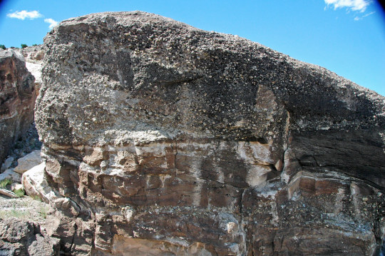
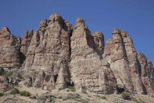
Seeing Camel Rock from a New Perspective: A Drones Eye View
Experience the awe-inspiring Camel Rock, a breathtaking ancient rock formation made up of folded 470 million-year-old turbidite beds that were shaped by underwater avalanches 450 million years ago.
Visitors can enjoy this popular scenic attraction from a viewing platform, relax in the shade of towering trees at the picnic area, and utilize the convenient toilet facilities and ample car and caravan parking.
Embark on the exhilarating 1.5-kilometer walking track located behind the viewing platform, leading to Murunna Point. Here, you'll discover elevated lookouts offering panoramic ocean views and a glimpse of Gulaga (Mt Dromedary) and Wallaga Lake as it meets the sea.
Camel Rock Surf Beach is a paradise for surfers, swimmers, snorkelers, and fishing enthusiasts. Explore the captivating rock pools and enjoy the summer months with lifeguard-patrolled waters and protection from north-easterly winds.
Convenient parking is available at Camel Rock Beach car park, accessible via an unmarked road off Wallaga Lake Road. Don't miss the chance to experience the magic of Camel Rock and its surrounding natural wonders!
0 notes
Text
Biological Characteristics of Water
Water has three qualities, for example physical, synthetic and natural qualities. The crude treated water can be checked and investigated by considering and testing these qualities as made sense of underneath:
The turbidity is estimated by a turbidity pole or by a turbidity meter with optical perceptions and is communicated as how much suspended matter in mg/l or parts per million (ppm). For water, ppm and mg/l are around equivalent. The standard unit is what is delivered by one milligram of finely partitioned silica (more full's earth) in one liter of refined water.
Biological Characteristics of Water
Turbidity Bar: The turbidity can be handily estimated in the field with the assistance of a turbidity pole. It comprises of an aluminum bar which is graduated as to give turbidity straightforwardly in silica units (mg/l) Turbidimeter: The turbidity can be effectively estimated in the research facility with the assistance of an instruments called turbidity meter. As a rule, a turbidity meter deals with the guideline of estimating the impedance brought about by the water test to the entry of light beams. Jackson's light Turbidimeter: The level of water section will hence be something else for less turbid water as well as the other way around. Longer the light way bring down the turbidity. Such a turbidimeter can not gauge turbidites lower than 25 JTU. It tends to be utilized for normal sources just and can not be utilized to quantify the turbidity of treated water supplies, for which Baylis turbidity meter or current nephelometers are utilized. Baylis Turbidimeters One of the two glass tubes is loaded up with water test (whose turbidity I to be estimated) and the other is loaded up with standard water arrangement of known turbidity. The electric bulb is lit and the blue variety in both the cylinders is seen from the highest point of the instrument. Current Nephelometer: for low turbidity under 1 unit. NTU - Nephelometric Turbidity Units FTU - Formazin Turbidity Units Proportion turbidimeter: Stream water has most extreme measure of turbidity.
2. Variety
AdPushupReport this promotion
The presence of variety in water isn't frightful according to wellbeing perspective, yet may ruin the shade of the garments being washed. The standard unit of variety is what is created by one milligram of platinum cobalt broke up in one liter of refined water. For public supplies, the variety number on cobalt scale shouldn't surpass 20 and ought to be ideally under 10. Not set in stone by an instrument is known as tintometer.
3. Taste and Scent
The degree of taste or scent present in a specific example of water is estimated by a term called smell force, which is connected with the edge scent or limit scent number. Water to be tried is accordingly continuously weakened with smell free water, and the combination at which the recognition of scent by human perception is recently, not entirely set in stone. The times the example is weakened addresses the edge smell number. For public supplies, the water ought to for the most part liberated from scent, for example the limit number ought to be 1 and ought to never surpass 3.
4. Temperature of Water
For consumable water, temperature of about clip_image002C is attractive. It ought not be more than
5. Explicit Conductivity
The aggregate sum of broken down salts present in water can be effectively assessed by estimating the particular conductivity of water.
Compound Qualities of Water
1. Absolute Solids and Suspended Solids
All out solids (suspended solids + broke down solids) can be gotten by dissipating an example of water and gauging the dry buildup left and gauging the buildup left on the channel paper. The suspended strong can be found by separating the water test. Absolute passable measure of solids in water is by and large restricted to 500 ppm.
Hard waters are unfortunate since they might prompt more noteworthy cleanser utilization, scaling of boilers, causing consumption and incrustation of lines, making food bland and so forth. Transitory Hardness: On the off chance that bicarbonates and carbonates of calcium and magnesium are available in water, the water is render hard briefly as this hardness can be eliminated somewhat by basic bubbling or to full degree by adding lime to water. Such a hardness is known as transitory hardness or carbonate hardness. Super durable Hardness: If sulfates, chlorides and nitrates of calcium or magnesium are available in water, they can not be eliminated at al by straightforward bubbling and in this way, such water require unique treatment for mellowing. Such a hardness is known as long-lasting hardness or non-carbonate hardness. It is brought about by sulfates, chlorides, nitrates of Ca and Mg. Carbonate hardness = All out hardness or Alkalinity (which at any point is less) Non-carbonate hardness = Absolute hardness - Alkalinity
Carbonate hardness is equivalent to the complete hardness or alkalinity which at any point is less
Non-carbonate hardness is the complete hardness in overabundance of the alkalinity. Assuming the alkalinity is equivalent to or more prominent than the absolute hardness, there is no non-carbonate hardness.
One French level of hardness is equivalent to 10mg/l of CaCO3.
One English level of hardness is equivalent to a hardness of 14.25mg/l.
Water with hardness upto 75 ppm are thought about delicate or more 200 ppm are thought about hard in the middle between is viewed as decently hard.
Underground waters are for the most part harder than surface waters.
The endorsed hardness limit for public supplies range between 75 to 115 ppm.
4. Chloride Content
The chloride content of treated water to be provided to people in general shouldn't surpass a worth of around 250 ppm. The chloride content of water can be estimated by titrating the water with standard silver nitrate arrangement involving potassium chromate as marker.
(5) Nitrogen Content
The presence of nitrogen in water might happen in at least one of the accompanying reasons:
Free alkali: It shows absolute first phase of disintegration of natural matter. It shouldn't surpass 0.15mg/l
Albuminous or Natural Matter: It shows the amount of nitrogen present in water before the deterioration of natural liquid has begun. It shouldn't surpass 0.3mg/l
Nitrites: Not completely oxidized natural matter in water.
Nitrates: It shows completely oxidized natural matter in water (addressing old contamination).
Nitrites is exceptionally risky and consequently the passable measure of nitrites in water ought to be nothing.
Alkali nitrogen + natural nitrogen = kjeldahl nitrogen
Nitrates in water isn't hurtful. Anyway the presence of a lot of nitrates in water may unfavorably influence the wellbeing of newborn children causing a sickness called methemoglobinemia normally called blue child illness.
The nitrate fixation in homegrown water supplies is restricted to 45 mg/l.
6. Metal and other synthetic substances in water:
Iron - 0.3ppm, abundance of these reason discolouration of garments. Manganese - 0.05ppm Copper - 1.3ppm Sulfate - 250 ppm Fluoride - 1.5 ppm, overabundance of this impacts human lungs and other respiratory organs. Fluoride grouping of under 0.8 - 1.0 ppm cause dental depression (tooth rot). In the event that fluoride fixation is more noteworthy than 1.5ppm, causing spotting and discolouration of teeth (a sickness called fluorosis).
7. Broken down gases
Oxygen gas is by and large consumed by water from the environment yet it being polished off by unsteady natural matter for their oxidation. Thus, assuming the oxygen present in water is found o be not exactly its immersion level, it demonstrates presence of natural matter and subsequently making the waters dubious.
0 notes
Text
Evidences of Large-Scale Shearing from South-Eastern Extension of The Mahakoshal Belt, Covering Parts of Sidhi & Singrauli Districts of Madhya Pradesh and Sonbhadra District, Uttar Pradesh, India- Crimson Publishers
Evidences of Large-Scale Shearing from South-Eastern Extension of The Mahakoshal Belt, Covering Parts of Sidhi & Singrauli Districts of Madhya Pradesh and Sonbhadra District, Uttar Pradesh, India by Banerji DC in Integrative Journal of Conference Proceedings
Abstract
The WNW-ESE trending arm of the Mahakoshal belt, extending towards south-east in the state of Jharkhand, through U.P, exposes variety of structural features those are uncommon in main Mahakoshals having ENE-WSW trend. The turbidites, said to be characteristic of the Parsoi Formation of the WNW trending arm, appear to be shear generated structures, having imprints across the length and width of the arm. Evidences of bulk flow along the pervasive foliation make it a mylonitic foliation, restricting possibility of survival of primary structures.
Read more articles in our site: https://crimsonpublishers.com/icp/fulltext/ICP.000526.php
For more articles in our journal click on: https://crimsonpublishers.com/icp/index.php
0 notes
Text
Pacific northwest earthquake

Not until a 1990 report would turbidites be reinterpreted as clues to Cascadia earthquake history. The sediment cores were collected to learn about turbidites-beds of sand and mud laid down by bottom-hugging, sediment-driven currents that infrequently emerged from submarine canyons onto the deep ocean floor. Plate tectonics was then such a new idea that scientists were just beginning to recognize the Cascadia subduction zone as a tectonic plate boundary. Those Nixon-era cores were the work of researchers unconcerned with earthquakes. The new report points to confounding evidence from a much larger suite of cores that were collected and first analyzed by University of Washington and Oregon State University scientists in the late 1960s and early 1970s. A subset of cores from this area underpins influential estimates of Cascadia earthquake size and recurrence that were published in 2012. The report reappraises sediment cores that were collected near the foot of the continental slope offshore Washington. How big was each of the earthquakes? Did they occur twice as often along one part of the subduction zone as another? The report concludes that extracting such details from deep-sea sediments is more complicated than was previously thought. What the report asks instead is how much geologists can say, with confidence, about the history of those earthquake going back thousands of years. The new report does not question whether the Cascadia subduction zone repeatedly produces enormous earthquakes. The estimates affect public safety through seismic provisions in building design and tsunami limits on evacuation maps. Geologic studies in the past three decades have provided increasingly specific estimates of Cascadia earthquake sizes and repeat times. The report focuses on the Cascadia subduction zone-a giant active fault that slants eastward beneath the Pacific coast of southern British Columbia, Washington, Oregon, and northern California. Geological Survey, the University of Washington, and other universities. Nearly forgotten research from decades ago complicates the task of quantifying earthquake hazards in the Pacific Northwest, according to a new report from scientists at the U.S.
0 notes
Photo

15 notes
·
View notes
Text
Monday Musings
I was looking at Lagerstätten one day and realized that a vast number of them are found in Cambrian age rocks. It got me thinking: why are so many found in Cambrian rocks? Let's take a look and see what these have in common.
Emu Bay Shale, Australia

Lower Cambrian, depositional environment: restricted basins on inner shelf.
Kinzers Formation, Pennsylvannia
Middle Cambrian, depositional environment: deep water, outer shelf
Burgess Shale, British Columbia
Middle Cambrian, depositional environment: below storm wave base
Spence Shale, Utah and Idaho
Middle Cambrian, depositional environment: continental shelf (both inner and outer).
Marjum Formation, Utah

Middle Cambrian, depositional environment: deep water.
Wheeler Shale, Utah
Middle Cambrian, depositional environment: below shelf where turbidites are deposited.
Weeks Formation, Utah

Middle Cambrian, depositional environment: gentle slope below the carbonate platform.
Maotianshan Shale, China
Early-Middle Cambrian, depositional environment: below turbidity currents where turbidites form.
Sirius Passet Formation, Greenland
Middle Cambrian, depositional environment: slope below carbonate platform
Sinsk Formation, Russia

Early Cambrian, slope below carbonate platform
So, as we can see, most of these were formed in the Middle Cambrian below a carbonate platform or shelf also known as a reef. It would seem that if you want to be exceptionally preserved, live along the continental shelf slope and get buried in mudslides, or storm deposits.

Each of the red stars represents one of our lagerstätten. We can see that they were all within the tropics and all were on shallow continental shelves. Neat, huh?
7 notes
·
View notes
Photo

Submarine canyons
The waters of the Earth’s oceans hide many fascinating features. This image shows the topography offshore of the city of Los Angeles.
Like many areas of the world, the area just offshore is shallowly sloped and part of the continental crust, an area known as the continental shelf. That continent ends at a sharp break known as the continental slope, which slopes more steeply down toward the open ocean. At this boundary off Los Angeles, giant canyons have been cut. These are remnants of the recent glaciations. Sea level was lower, exposing parts of the continental shelf. Rivers including the San Gabriel River and the Santa Ana River migrated along these shelves, eroding into them and fixing their position in the form of these canyons. When the most recent glaciation ended, the oceans returned and submerged the canyons, leaving them stranded and hidden from view.
Despite being beneath the waters, these canyons still are active. Sediment carried by rivers to the ocean accumulates at the canyon heads and on occasion that sediment will tumble down, forming submarine avalanches and deposits of turbidites at the base. Similar canyons are found at the intersection between river valleys and the continental slope around the world, a remnant of the Pleistocene glaciations.
-JBB
Image credit: http://commons.wikimedia.org/wiki/File:Canyons_off_LA.jpg
Read more: http://www.nrdc.org/oceans/canyons/ http://www.britannica.com/EBchecked/topic/570847/submarine-canyon http://sanctuarysimon.org/regional_sections/submarineCanyons/overview.php
75 notes
·
View notes
Text
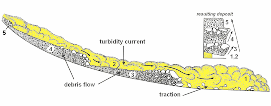
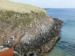
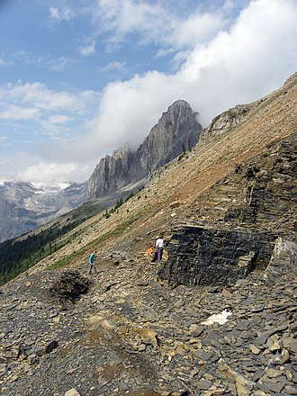
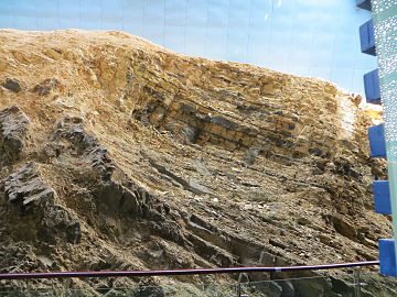
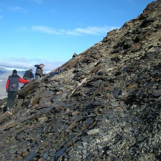
the only thing getting me thru geology, a subject ive traditionally found Very Boring, is my professors genuine enthusiasm for rocks. today someone said “turbidite [a kind of rock formation] sounds like a pokemon name” and he replied “if turbidites were a pokemon they’d have ALL THE POWERS. they’re so cool”. this is what turbidites look like

#very important to note he pronounced pokemon 'pokiemon'#it adds to the flavor of this post#in his defense i cherrypicked a less interesting turbidite formation#there are some that look kind of wild#they get deposited horizontally like this but in the right conditions they can get pushed + tipped up vertically#so theres beaches with big layered rocks just kind of . jutting out at odd angles
10 notes
·
View notes
Photo

#高知県 #室戸市 #室戸岬 #世界ジオパーク #世界ユネスコジオパーク #室戸世界ユネスコジオパーク #turbidite #turbidites #タービダイト層 #ジオパーク (Muroto, Kochi) https://www.instagram.com/p/BupHijrlALR/?utm_source=ig_tumblr_share&igshid=1nmeiud3r49xj
0 notes
Last Seen Blogs

pmgawareness
PMG Awareness Organization, INC.
pmgawareness.org

demented-lizardry-blog
Lizard-Craft

hello-moya-us-blog
제목 없음

nellientx
This could get dangerous...

silentnewtbark
SilentNewtBark