#QGIS tutorial
Explore tagged Tumblr posts
Visit Tumblr Blog
Explore Tumblr blogs with no restrictions, modern design and the best experience.
Last Seen Tumblr Blogs


Fun Fact
130K people were victims of a chain letter scam that affected Tumblr in May 2011.
Text
Mastering QGIS Desktop 3.34 LTR: From Beginner to Pro.
English Video tutorial, just for $9.99 (NORMAL price $19.9). Get it once and you will get endless access right.
Unlock the full potential of QGIS Desktop 3.34 LTR! This comprehensive guide takes you from the basics to advanced spatial analysis, helping you master GIS techniques, data visualization, and automation with Python. Whether you're a beginner or an experienced user, this book will elevate your GIS skills.
#QGIS 3.34#QGIS tutorial#GIS software#spatial analysis#QGIS Python#mapping software#open-source GIS#QGIS for beginners
0 notes
Text

No idea if this person follows me BUT while the industry standard for GIS software (ArcGIS pro) is incredibly expensive, there are open source alternatives like QGIS. A lot of governments and organizations also have open data portals that you can grab data from (shapefiles, CSVs, rasters, whatever).
I've kind of been taught ground-up in person so I don't have recommendations on video tutorials for teaching basic concepts sadly. Bolstadt GIS fundamentals is good and was dirt cheap by textbook standards though (was like $40 iirc).
"Learning GIS" I guess also depends on what you want to do with it? If you want to mess around with cartography and data visualization you could probably just give yourself some pet projects.
#of course i would never. never pirate a textbook. cough.#i like highlighting while reading though so im happy i bought a physical copy of that one specifically#iirc open source GIS software also requires you to lean on SQL and python a little more. though i could be wrong#not art
30 notes
·
View notes
Note
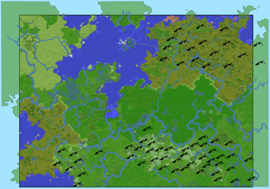
Hello my saint Mapmaker! That Beleriand GIS map is everything to me right now. I find myself in Beleriand distance hell and this is like a fruit from the gods.
Please, if I can ask further: * What would be the distance across Hithlum from Eithel Sirion to Cirith Niniach? * Estimations on the length and width of Ard-galen/Anfauglith (let's say between Ered Wethrin to the Blue Mountains, and then Dorthonion to Thangorodrim)?
I don't know anything about handling geopackages but if you have tips I'd love to have it so I don't pester you infinitely with asks 😅
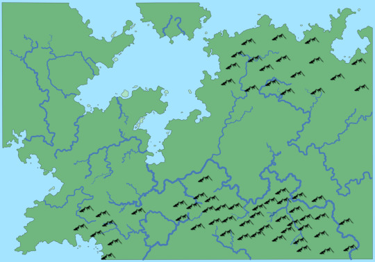
Hi! I'm so glad you find this useful! I don't know why I've never thought about this before, it seems so obvious now :D
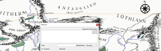
in a straight line, the distance between Cirith Ninniach and Eithel Sirion is approximately 214 km or ~133 miles, and Eithel Sirion–Blue Mountains is about 638 km / 397 miles.
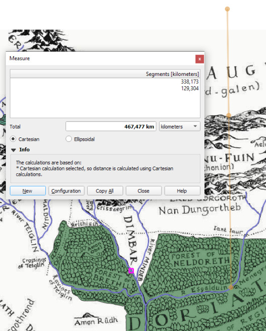
I will try and georeference the map from War of the Jewels tomorrow, then I can tell you about the north–south extents. I can NOT take the line in the Silm seriously that says "the gates of Morgoth were but (sic!) one hundred and fifty leagues distant from the bridge of Menegroth". On the map that looks absolutely ridiculous XD the Anfauglith would be as large as the rest of Beleriand!
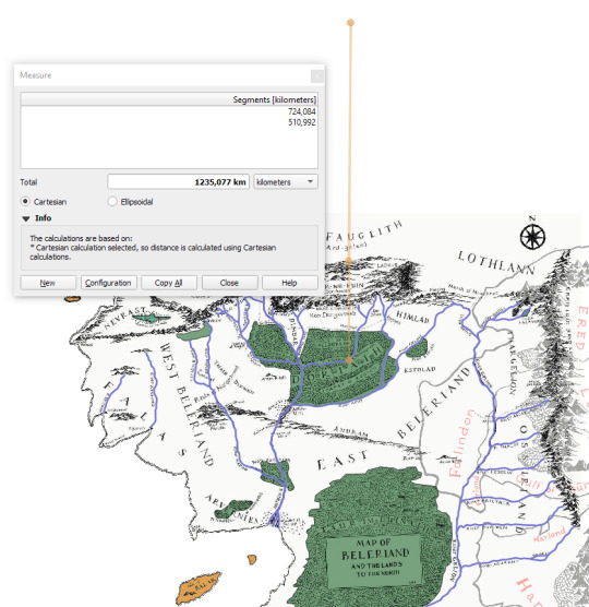
Christopher writes in HoMe5, "according to the scale of the second Map […] the distance [Menegroth–Thangorodrim] was scarcely more than seventy [leagues]". That would mean Dorthonion is about 80 miles / 130 km wide.
You can pester me all you want :D but If you're interested I could put together a very basic tutorial on how to load a geopackage into QGIS and measure basic stuff, it's not very hard and QGIS is free :)
19 notes
·
View notes
Text
a year into my master's—some favorite resources
context: i am studying an MRes in sociology at a european university.
notion—lifesaver
google drive—because my school runs on google
adobe acrobat plugin for google drive—great for annotations
goodnotes—better than notion if you have access to powerpoints before class! (implies having a tablet)
slidesgo—cute presentation designs, can be edited and made into templates!
pomodoro kitty—cutest website ever, keeps me accountable!
thematic selections on theconversation (in my case, "environment")—great for keeping up with the latest research in your area of choice!
greek alphabet letters website—for math/stats
stack overflow—a lifesaver for those of us learning r
statistics by jim—simple but amazing explanations
center for spatial research tutorials (columbia university)—great for qgis!
plus jstor and some others i cannot legally name, obviously...
that's it! i don't really use paper. hopes this reaches the right audience <3 good luck with back to school prep!
39 notes
·
View notes
Text
new project yippee yahoo
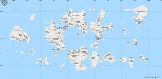
For about a year, I've had the vague idea of making a map of the Empires season 1 world for worldbuilding purposes. I've had headcanons about geography for a while, and have wanted to flesh out locations and trade routes in a more realistic way, but didn't have a great way to go about it until recently! I've been introduced to a mapping software called QGIS because of a class I'm taking. I also happen to be in an earth systems class that I need to get my required science credits out of the way (curse core curriculum requirements).
There's still a lot of work to do, but I thought I might as well share what I have so far in case anyone wants to follow the project. I've been using this tutorial in conjunction with what I know from my classes and my own research. Once I'm finished, I'll upload all the files and some pictures of each layer, because while QGIS is free, it's also clunky and not very intuitive.
Things are still liable to change right now. Some rivers and mountains might get shuffled around, but this will be the general geography of the world.
I'm going to start tagging it as #esmp mapping project, if you'd like to follow my progress!
16 notes
·
View notes
Text
tagged by @moistvonlipwig for this (but answering on my sideblog)
Fave color: orange 🧡 my beloved
Last song: night shift by lucy dacus
Last book: technically in the middle of reading the three body problem though i haven't actually touched it in months. been so busy. i can't recall the last time i actually finished a book but i have been reading shakespeare plays at work to procrastinate
Last movie: it's been so long since i watched a movie i genuinely do not remember....... i'm always saying i need to watch more but then i forget
Last TV show: neck deep in my better call saul rewatch. last new show i watched was hacks
Sweet/savory/spicy: savoryy
Relationship Status: uhhhhhh confusing situationship is back on with the roommate i guess. idk.
Last thing I googled: some qgis tutorial thing for work probably
Looking forward to: ending my internship today. get me outta hereeee
Current obsessions: well as is obvious to anyone who has looked at this blog in the last couple weeks. i cannot get better call saul and specifically kim wexler out of my head. only thing there's room for in there lately
tagging the mutualss @fantastic-mr-corvid @arielluva @eldragon-x @colossalsquidz but absolutely no pressure or anything :]
5 notes
·
View notes
Text
So let's get into the nitty-gritty technical details behind my latest project, the National Blue Trail round-trip search application available here:
This project has been fun with me learning a lot about plenty of technologies, including QGis, PostGIS, pgRouting, GTFS files, OpenLayers, OpenTripPlanner and Vita.
So let's start!
In most of my previous GIS projects I have always used custom made tools written in ruby or Javascript and never really tried any of the "proper" GIS tools, so it was a good opportunity for me to learn a bit of QGIS. I hoped I could do most of the work there, but soon realized it's not fully up to the job, so I had to extend the bits to other tools at the end. For most purposes I used QGis to import data from various sources, and export the results to PostGIS, then do the calculations in PostGIS, re-import the results from there and save them into GeoJSON. For this workflow QGIS was pretty okay to use. I also managed to use it for some minor editing as well.
I did really hope I could avoid PostGIS, and do all of the calculation inside QGIS, but its routing engine is both slow, and simply not designed for multiple uses. For example after importing the map of Hungary and trying to find a single route between two points it took around 10-15 minutes just to build the routing map, then a couple seconds to calculate the actual route. There is no way to save the routing map (at least I didn't find any that did not involve coding in Python), so if you want to calculate the routes again you had to wait the 10-15 minute of tree building once more. Since I had to calculate around 20.000 of routes at least, I quickly realized this will simply never work out.
I did find the QNEAT3 plugin which did allow one to do a N-M search of routes between two set of points, but it was both too slow and very disk space intense. It also calculated many more routes than needed, as you couldn't add a filter. In the end it took 23 hours for it to calculate the routes AND it created a temporary file of more than 300Gb in the process. After realizing I made a mistake in the input files I quickly realized I won't wait this time again and started looking at PostGIS + pgRouting instead.
Before we move over to them two very important lessons I learned in QGIS:
There is no auto-save. If you forget to save and then 2 hours later QGIS crashes for no reason then you have to restart your work
Any layer that is in editing mode is not getting saved when you press the save button. So even if you don't forget to save by pressing CTRL/CMD+S every 5 seconds like every sane person who used Adobe products ever in their lifetimes does, you will still lose your work two hours later when QGIS finally crashes if you did not exit the editing mode for all of the layers
----
So let's move on to PostGIS.
It's been a while since I last used PostGIS - it was around 11 years ago for a web based object tracking project - but it was fairly easy to get it going. Importing data from QGIS (more specifically pushing data from QGIS to PostGIS) was pretty convenient, so I could fill up the tables with the relevant points and lines quite easily. The only hard part was getting pgRouting working, mostly because there aren't any good tutorials on how to import OpenStreetMap data into it. I did find a blog post that used a freeware (not open source) tool to do this, and another project that seems dead (last update was 2 years ago) but at least it was open source, and actually worked well. You can find the scripts I used on the GitHub page's README.
Using pgRouting was okay - documentation is a bit hard to read as it's more of a specification, but I did find the relevant examples useful. It also supports both A* search (which is much quicker than plain Dijsktra on a 2D map) and searching between N*M points with a filter applied, so I hoped it will be quicker than QGIS, but I never expected how quick it was - it only took 5 seconds to calculate the same results it took QGIS 23 hours and 300GB of disk space! Next time I have a GIS project I'm fairly certain I will not shy away from using PostGIS for calculations.
There were a couple of hard parts though, most notably:
ST_Collect will nicely merge multiple lines into one single large line, but the direction of that line looked a bit random, so I had to add some extra code to fix it later.
ST_Split was similarly quite okay to use (although it took me a while to realize I needed to use ST_Snap with proper settings for it to work), but yet again the ordering of the segments were off a slight bit, but I was too lazy to fix it with code - I just updated the wrong values by hand.
----
The next project I had never used in the past was OpenTripPlanner. I did have a public transport project a couple years ago but back then tools like this and the required public databases were very hard to come by, so I opted into using Google's APIs (with a hard limit to make sure this will never be more expensive than the free tier Google gives you each month), but I have again been blown away how good tooling has become since then. GTFS files are readily available for a lot of sources (although not all - MAV, the Hungarian Railways has it for example behind a registration paywall, and although English bus companies are required to publish this by law - and do it nicely, Scottish ones don't always do it, and even if they do finding them is not always easy. Looks to be something I should push within my party of choice as my foray into politics)
There are a couple of caveats with OpenTripPlanner, the main one being it does require a lot of RAM. Getting the Hungarian map, and the timetables from both Volánbusz (the state operated coach company) and BKK (the public transport company of Budapest) required around 13GB of RAM - and by default docker was only given 8, so it did crash at first with me not realizing why.
The interface of OpenTripPlanner is also a bit too simple, and it was fairly hard for me to stop it from giving me trips that only involve walking - I deliberately wanted it to only search between bus stops involving actual bus travel as the walking part I had already done using PostGIS. I did however check if I could have used OpenTripPlanner for that part as well, and while it did work somewhat it didn't really give optimal results for my use case, so I was relieved the time I spend in QGIS - PostGIS was not in vain.
The API of OpenTripPlanner was pretty neat though, it did mimic Google's route searching API as much as possible which I used in the past so parsing the results was quite easy.
----
Once we had all of the data ready, the final bit was converting it to something I can use in JavaScript. For this I used my trusted scripting language I use for such occasion for almost 20 years now: ruby. The only interesting part here was the use of Encoded Polylines (which is Google's standard of sending LineString information over inside JSON files), but yet again I did find enough tools to handle this pretty obscure format.
----
Final part was the display. While I usually used Leaflet in the past I really wanted to try OpenLayers, I had another project I had not yet finished where Leaflet was simply too slow for the data, and I had a very quick look at OpenLayers and saw it could display it with an acceptable performance, so I believed it might be a good opportunity for me to learn it. It was pretty okay, although I do believe transparent layers seem to be pretty slow under it without WebGL rendering, and I could not get WebGL working as it is still only available as a preview with no documentation (and the interface has changed completely in the last 2 months since I last looked at it). In any case OpenLayers was still a good choice - it had built in support for Encoded Polylines, GPX Export, Feature selection by hovering, and a nice styling API. It also required me to use Vita for building the application, which was a nice addition to my pretty lacking knowledge of JavaScript frameworks.
----
All in all this was a fun project, I definitely learned a lot I can use in the future. Seeing how well OpenTripPlanner is, and not just for public transport but also walking and cycling, did give me a couple new ideas I could not envision in the past because I could only do it with Google's Routing API which would have been prohibitively expensive. Now I just need to start lobbying for the Bus Services Act 2017 or something similar to be implemented in Scotland as well
21 notes
·
View notes
Text
free (!!) GIS training courses
was perusing uSaskatchewan's HGIS Lab website (as one does) and found that they had free-to-access courses and tutorials for both getting started with GIS work in a historical context, as well as data entry and analysis. there are courses related both to QGIS (open source program) and arcGIS/the ESRI suite (very expensive for personal use, but still remains the industry standard). The data entry course is based on the Microsoft suite.
a couple of caveats: (1) I have not personally made use of these courses myself and cannot speak to the up-to-dateness of the info within, and (2) the HGIS Lab specifies that the courses are aimed at scholars, and so I'm guessing would assume that you know what goes into quality research within these fields and is moreso aimed at teaching you how to use these tools within that context.
anyway it made me very excited to see and I just thought I'd share it into the Tumblr void in case it is helpful to anyone!
#archaeology#history#geographic information systems#free courses#reference#university of saskatchewan#uSask#arcGIS#qgis
0 notes
Text

Mastering QGIS Desktop 3.34 LTR: From Beginner to Pro. Unlock the full potential of QGIS Desktop 3.34 LTR! This comprehensive guide takes you from the basics to advanced spatial analysis, helping you master GIS techniques, data visualization, and automation with Python. Whether you're a beginner or an experienced user, this book will elevate your GIS skills.
English Video tutorial, just for $9.99 (NORMAL price $19.9). Get it once and you will get endless access right. Visit:
#QGIS 3.34#QGIS tutorial#GIS software#spatial analysis#QGIS Python#mapping software#open-source GIS#QGIS for beginners
0 notes
Text
Nu Maybreak? (thread 16^12, article 0x27/?)

Previous article in the thread:
(What could I do to make some money on my own & prosper creatively?)
"Gygax75" content checklist (stage 1)
Physical notebook (writing notes, doodle sketches & draft ideas real fast)
Artistic pieces, printables & other self-fundraising deliverables (also to be used as media library and style guide to refer back to)
GLOSS personal wiki with QOwnNotes (as to modularize topics & shrink into MVP)
Inspiration reference document (multimedia moodboards including visual, audio, video, 3D... assets & components)
Cartoon pitch slideshow (with motivation, target audience, costs & all, must contain a few USPs and be easily digestible)
USPs: { GLOSS publishing & licensing ethics, insightfully grounded optimism, Lisp programming permeates this realmscape, advanced android clades living harmoniously side by side with biological lifeforms, mutual empowerment & worker themes, "Syndicalist Cooperatives" & "Harmonious World" rules, curiosity-driven mysticism worldview transparency + empathic humanism; }

Manifestation log & gratitude journal
Ebook self-published source
Audiobook / curated podcast?
Fiction novella / novel?
Theater show-piece?
Short animation films
Movie from textual corpus?
Original musical score album
Analog recorder-produced music album
Choice-thread addventure gamebook
Artbooks
Activitybooks / Workbooks
LGBTQ+ parables for kids (motivational stories)
History leaflets on "Syndicalism", "Georgism" & "Harmony" during the last centuries
Illustrated retro cartoon comics
Conlang copysheets & worksheets
Artist card deck of original character profiles
Character journals and tracker pages
TTRPG setting guidebook
TTRPG adventures
TTRPG homebrew custom rules, procedures, pregens & overall "baked" content
Foundry VTT modules
"Angora" video game gridmap revamp
Trial Engine 3D game + social ecosystem?
GPlates base tectonics refactor to put into GProjector
QGIS+OSM model
SVG toymaker actor system
Unity procedural social ecosystem toybox
Nu advanced dress-up chambers
LiSE linguistical simulations
Godot/Redot textual addventures -> 3D first person games
Trial Engine demos & animated recordings
KDE e.v. software ecosystem introduction
Instagram tutorial-esque storylet experiments
Either way, have fun with Emacs ORG-mode & Argdown!
Sights onto the far distant future? Dare to care & imagine better, don't forget to act your way towards such. After all, we were promised that better was within reach so may as well make it factual, as it should.


Now I shall go practice some mindfulness...
0 notes
Text
review laptop asus tuf gaming
saya menggunakan laptop asus tuf gaming a15 ini selama hampir 2 tahun. bobot laptop dengan chargernya adalah 3 kg. touchpad-nya lumayan nyaman. tapi, pengalaman memakai laptop ini lebih maksimal ketika saya pakai mouse, apalagi untuk pekerjaan teknis yang butuh banyak klik.
dengan prosesor amd ryzen 9, laptop ini bisa diajak multitasking. saya pernah membuka beberapa software berat sekaligus. waktu itu saya lagi mau buat peta, jadi saya membuka qgis dan youtube untuk melihat tutorial. pertengahan jalan, saya baru sadar kalau perlu mengumpulkan data sekunder lain. jadi saya berselancar lagi di google chrome, buka website bps beberapa daerah, buka ms. excel dan ms. word. setelah itu membalas peran di whatsapp, dan mengikuti diskusi online (masih sambil sesekali buka qgis).
setelah itu saya mulai merasa jenuh dengan kerjaan. saya memutuskan main gim di steam. saya main disco elysium selama kurang lebih 30 menit. kemudian saya coba main gim lain yaitu a little to the left selama kurang lebih 15 menit. tanpa menutup software steam, saya kembali ke qgis. sambil bolak-balik ke youtube untuk melihat tutorial. laptop ini juga sering saya ajak bekerja keras dan menyala selama hampir 24 jam. jika sedang banyak task, dia akan menyala lebih dari 12 jam selama 7 hari.
saat dipakai melakukan banyak hal, laptop ini bisa menahan suhunya jadi tidak terlalu panas. namun kalau ia dipakai untuk main gim, suhunya bisa naik drastis dan suara kipasnya jadi terdengar. tapi kenaikan suhu dan suara kipas ini masih bisa dimaklumi. yah, kalau di ruangan tertutup yang sepi, suara kipasnya akan kedengeran oleh teman kerja di dekatku, sih.
soal performa dan kualitas layar, saya puas menggunakan laptop ini. satu lagi komponen laptop ini yang sangat saya suka: KEYBOARD. laptop badak ini punya keyboard yang luas, EMPUK, suaranya cukup renyah, dan pas untuk tangan saya. tiap mengetik di laptop ini, pergelangan tangan saya akan menempel di sebelah touchpad, dan jari-jari saya bisa lincah bergerak menyusuri tiap alpabet, nomor, dan tanda baca. saya suka sekali mengetik di laptop ini :") saya rela menjadi notulen selama berjam-jam.
tapi laptop ini pernah ngambek :( kadang saya meninggalkannya dalam mode sleep terlalu lama. akibatnya ia tidak bisa berfungsi. layarnya menyala, tapi tidak merespon touchpad, keyboard atau mouse saya. akhirnya saya menunggu dia pulih. untungnya, dia selalu mau pulih tanpa saya bawa ke tempat servis
sayangnya, laptop ini tidak cocok untuk dibawa pergi-pergi jauh dan berpindah-pindah karena berat. Kalau saya mengajaknya pergi, artinya saya perlu bawa tas ransel yang besar agar ia aman. Perpaduan tas dan laptop ini akan terlihat terlalu ganteng ketika saya sedang ingin cantik. baterainya juga tidak terlalu awet, apalagi kalau membuka banyak aplikasi dan pekerjaan. tiap bepergian membawa laptop ini saya merasa was-was, takut ia menyenggol benda lain dan lecet. dan sebaliknya, saya khawatir laptop ini menyenggol benda lain dan dialah yang lecet. saya pernah membayangkan satu skenario begini: kalau saya pergi bersama laptop ini dan berjumpa orang yang menyebalkan, laptop ini bisa menjadi pelindung. caranya adalah saya menampar wajahnya dengan si laptop. niscaya dia akan merengek minta ampun.
mungkin, hari ini adalah hari terakhir saya menggunakan laptop ini :) ia akan kembali ke pemiliknya yang sesungguhnya. saya belum punya laptop milik sendiri, atau mengutip istilah teman saya, “laptop yang otonom”. jadi setelah ini saya akan mencari pinjaman laptop sampai tabungan cukup untuk beli atau mencicil laptop baru. anyway. saya sedang mengingat-ingat kemewahan yang saya rasakan/alami ketika menggunakan laptop ini.
performa baik, keyboard empuk, dan bisa diatur backlight-nya dengan berbagai warna juga, lho. saya paling suka pakai warna hijau dan biru
layar lebaaaarrrr dan jernih untuk nonton! sejak tahun 2020 saya terbiasa dengan layar laptop lebar (15-16 inci), jadi mata saya bisa leluasa melihat layar.
sensasi punggung pegal setelah seharian jalan bersama si badak. iya, pegel dan kadang sampai sakit :”) tapi saya tetap anggap ini adalah pengalaman yang baik :d
selalu mengecek keberadaan soket listrik saat tiba di suatu tempat
bisa bolak–balik buka tutup aplikasi tanpa nge-lag (kecuali saat kondisi laptop sudah cukup panas setelah dipakai dari pagi sampai malam selama beberapa hari. kadang dia nge-lag sedikit)
buat split screen lancar sekali :)) saya bisa buka zoom sambil buka google documents untuk mencatat, sembari buka google untuk browsing dan whatsapp untuk mengecek pesan. cukup seamless.
kalau dari awal laptop ini adalah milik saya dan tidak ada perjanjian mengembalikan, saya mau kok memakainya terus. yah, dengan segala konsekuensinya hehe. laptop ini juga menyediaan 2nd ssd slot :) jadi bisa upgrade ketika butuh.
itu hanyalah 7 kemewahan dan kebaikan yang paling saya ingat. terima kasih, laptop badak. kamu sudah menemani dan membantu saya dalam banyak hal. kamu juga sudah menjadi laptop tangguh yang saya bawa ke mana-mana. maaf ya, kadang saya ceroboh membenturkanmu dengan meja atau dinding. maaf juga saya kurang rajin dalam membersihan layar, keyboard, kipas dan sampah digital saya.


1 note
·
View note
Note
Kleo 🥺
I really am so sorry, because I unintentionally ghosted you 😭 I really didn't mean to, but I've just had so much work this week and the last one, and I'm one minor inconvenience away from a(nother) mental breakdown 🥴
Like it's 3 am right now and I'm recording a tutorial on how to create a map with level lines on qgis (because my students are dummy dumb and apparently can't use fucking Google), and then I have to grade a shitton of quizzes, tests and projects 📉
Still, I want you to know that I'm still extremely invested in both your reverse tarot game and the reading you sent to my DMs and as soon as I get this done I will reply to you... Like i read your messages and was all giddy about it, but I haven't had the time and mental space to sit down and properly type out my thoughts about it 🫂
I just wanted to say this so that you don't feel I'm not interested, it's just been tough these days and I'm still working on my ability to cope with stress in a healthy manner (it's bad I literally am failing at this 🤡)
I'm feeling quite 10 of Wands, with a dash of 8 of swords right now, but I will Chariot through this shit (I hope) and come back a Queen of Pentacles 😔✊
On a separate note, I'm also a winter girly! People get so negative about the gray weather but I just love it so much... Like anything above 23°C gets very unpleasant to me, and I just can't function in the summers!
Hope you get your refreshments soon 🙏
How do Easy and Dachi do in the summer? Do they have a hard time too? I hope not 🥺
Hello!
Please! Don't worry! I meant it more like a playful nudge. 😁 It's not like you would break my heart. I know life happens and everyone needs to prioritise 1000+1 thing. Make sure to put your well being first! 💖
There's no rush, really. 😉
Coping with stress is an important and quite life saving skill which isn't taught in schools but probably would make more sense than memorizing historical dates. 😎 And I say that as a real history enthusiast. You don't need to remember when Alexander The Great died, you can Google that, but learning how to cope with stress and pressure, that's a real life skill. 😂
I like your tarot use in expressing emotions and ambitions 😂 Genius!
I'm basically half a woman, half polar bear, 23°C is my maximum for comfort, too. Anything above is just slow murder. 🥵😂
We just came from a walk, we went at around 10 am and it was already hot but not scorching hot. They cope better than my first dog Spock (German Spitz), she was even fluffier than Easy and Dachi. But they don't like the heat either. Like they actively seek shade (so do I) and back at home they just drink and then lie down and sleep after walk. They are from South Korea, so they probably went through hotter weather than the one here in Prague. For extra hot days I have like the mobile air con? It looks more like air purifier but bigger and I can put it on when I want to slightly ease the heat in one room. It's def not strong enough for entire apartment but it will cool the living room sufficiently when needed. But I'm a master of cooling the apartment by airing it during night and early morning. I heard it's a typical Czech thing because we don't have air cons here, it's not a normal thing. So we get up in the middle of the night just to open all the windows to cool the rooms and once it's becoming hot, we close them, shut the blinds and this will more or less maintain the temperature until it's cooler outside again for airing. 😂 Yes, it's sort of complicated and requires getting up when you would like to sleep but it works and it isn't such a hit for the environment, because air cons are actually one of the reasons why people need to use air cons. 😂
So yeah, we are managing. Also the weather forecast predicts rainstorms on Sunday so the temperature should drop again. 🤞
Take care! 💖
0 notes
Text
Threat Detector QGIS tutorial: processing layers
To access the index with links to the full tutorial click here

We will start processing the layer corresponding to bdline_gb district_borough_unitary.
The image from above will be different in colours to yours. Don’t worry! QGIS loads layers with random colour symbology and it might look more like this:

You don’t need to change it, we are not going to use this layer, but a new one we will generate from it.
1. Open the Attribute Table of bdline_gb district_borough_unitary. You can access the Attribute Table by right clicking on the layer.
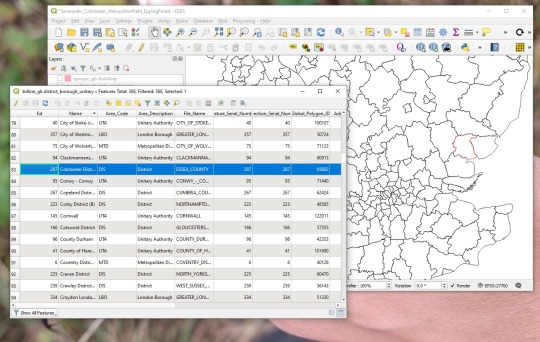
This Attribute Table contains all the data associated with the layer, such as area codes and descriptions, serial codes, administrative units id, census codes, hectares, etc. Each entry is a feature on the layer and is georeferenced.
2. Use the Select/filter tool (on the tool bar or Ctrl+F). We are going to filter and select our features by “Name”
3. I am working with several areas. First I search for “Sevenoaks” so I can add it to Current Selection. I repeat this steep as many times as I need, one for each area.
4.Once I have all my areas selected, I can export them into a new layer (I will need to select a new name and where to save it).
5. The new layer will be added to the left panel.
3 notes
·
View notes
Video
youtube
Here’s a #GIS tutorial on how to use basic #editing in #QGIS.
3 notes
·
View notes
Photo
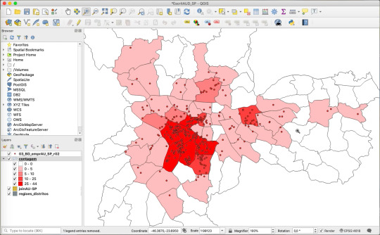
Como fazer mapa temático de contagem de pontos por distritos no QGIS (vídeo 2) Olá, pessoal. Nesse novo vídeo, explicamos como fazer um mapa temático com a contagem de pontos no QGIS, usando como referência polígonos de outra camada (em nosso exemplo, distritos municipais).
#arquitetura e urbanismo#como contar pontos#como contar pontos no QGIS#como fazer mapa de contagem no QGIS#contagem de pontos de localização#contagem de pontos georreferenciados#contagem de pontos importados do Excel no QGIS#dica#ferramenta GIS gratuita#georreferenciamento#GIS#GIS free#GIS gratuito#mapa de contagem no QGIS#mapa temático QGIS#passo a passo#QGIS#tutorial#vídeo explicativo
0 notes
Text
I have a website at least deployed, tomorrow I'll find some CSS I don't hate and set that up. Tonight I do the QGIS tutorial but first, 20 pushups and a shower. God I'm so pleased with myself lately in terms of productiveness (coming from a good emotional place of curiosity and hype) to elaborate, this week I have learned a ton about crypto, set up my own wallet and imported my BTC from a paper wallet, set up my coinbase account, purchased a (overpriced) raspi 4 so I can start an urbit server on it, taught myself basic use of Github Desktop, applied to 3 jobs, and started messing around with QGIS. I also finished reading The Two Towers. I feel good! All these things are things I enjoy or think are really worth doing, and I feel more fulfilled spending my time doing this than scrolling endlessly on tumblr (boring) or socializing (lol what socializing)
12 notes
·
View notes