#San Andreas Fault Zone
Text
Geology of Natural Disasters and How to write them into your fictional universe.
So, you want to write about a natural disaster to advance your plot and torture your players/characters even more? Let me tell you how, accurately.
I feel like unless it is a volcano, natural disasters are a pretty slept on plot drivers, and some of them are really cool and unique! Today, I will talk to you about land slides, earthquakes (And earthquake related disasters), and volcanoes.
Landslides: Probably one I see the least in stories, but one that would be incredibly interesting to write into a plot where they believe in curses. Landslides can happen along ocean bluffs, slightly hilly areas, and highly mountainous areas, this means it is something that can happen in most landscapes. But what can trigger a landslide? Mostly all you need to trigger a landslide could be just abnormally large amounts of rain, excessive deforestation (with a little bit of rain), or an earthquake. If you don't want to use deforestation or an earthquake as a catalyst, a really cool indicator that the land is slipping and may be prone to a collapse is J hooked trees.
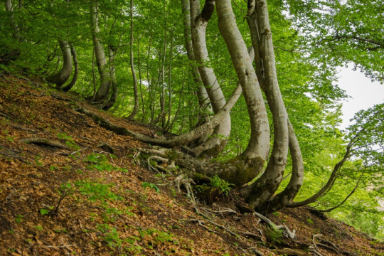
This indicates that there is soil creeping slowly over time, and it may lead to a major landslide.
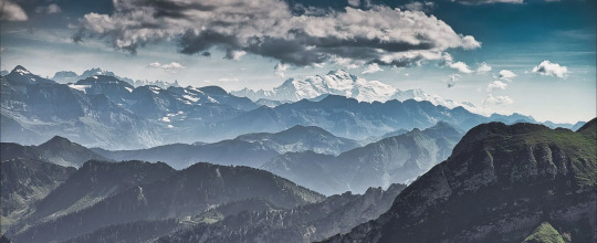
2. Earthquakes: Probably one of the easiest things to write, earthquakes can happen anywhere, but they are most common in places that are tectonically active areas. There are about three types of environments you can expect earthquakes to be common. The first is just rugged mountains, if your landscape looks like this, you should write in earthquakes. Associated hazards could be landslides, avalanches, and large falling rocks.
The next landscape could be a thin mountain range, next to the ocean, very scenic, but very dangerous. Essentially, I am describing a subduction zone environment.
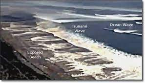
Earthquakes in these areas could equal a couple different associated disasters. Scenario one: A very large earthquake happens, and the ocean begins to recede. This is a tsunami, enough said. If you are writing a tsunami though, please, please, do not write it as a large wave, thank you. Also, a common way people are hurt by tsunami's are from them going into the ocean because they don't understand a tsunami is going to happen.
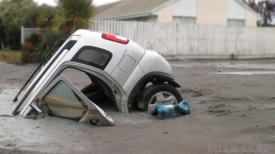
Scenario two: A large earthquake happens, your characters are in a valley and suddenly the ground begins to liquify as the ground shakes, once the shaking stops, the ground becomes solid like nothing ever happened, except everything has suddenly sunk into the now hard ground. This is called liquefaction and it typically happens in areas that have loose dirt or lots of saturated soil.
Scenario three: There are a lot of small earthquakes, they do not cause a lot of damage, but you begin to notice that one of the isolated mountains has a plume rising. Earthquakes can indicate lava moving underground and the filling of magma chambers.
The next environment that can host lots of earthquakes would be regions that have a lot of really deep valleys and small mountain ranges (not cone volcanoes), but overall seems pretty flat.
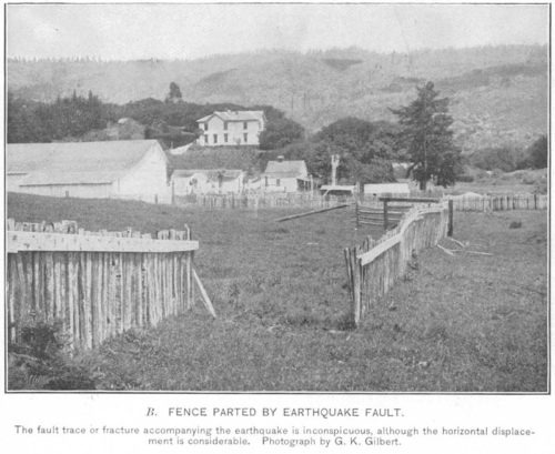
This indicates a transform fault like the San Andreas. If you want to hint at there being earthquakes in the area, you can show fence posts that are suddenly several feet out of line at a dilapidated farm or something similar.
(These earthquakes are different because they are cased from sideways movement, not an up-and-down movement this hint can only be used for this environment). Volcanoes would not be found here, but liquefaction and landslides could still occur here.
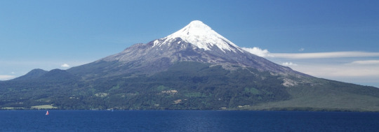
4. Volcanoes: If you thought earthquakes had a lot of information, volcanoes do too. First you have to ask yourself, what kind of volcano you want to have, what kind of eruption style? So lets break down the kind of eruptions you can have and what their landscapes look like. Hawaiian Shield volcano: This will produce a smooth fast lava, the landscape typically is pretty flat, but there will be small cones and the rocks can have a ropey or jagged texture and the rocks will be almost exclusively black to dark red.
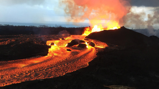
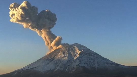
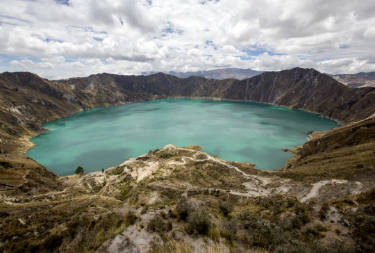
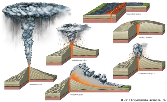
Stratovolcanoes: These will be solitary mountains, typically, that look like perfect cones (Picture shown in earthquake section). These will have large ash cloud eruptions and pyroclastic flows, they may have some lava, but typically most damage is done from the pyroclastic flows (think Pompeii). Some hints of these, other than describing the cone features (which can be hidden by other mountains), would be to talk about petrified wood! Trees can get fossilized in the ash and I imagine it would be very strange to find this rock that clearly looks to be a piece of wood, but its a rock. Subcategory- Calderas: Used to be a large stratovolcano, but they erupt so explosively that the entire cone collapses and creates a basin.
There are a lot of kinds of volcanoes out there, so forgive me for just putting an infographic and then talking to you about these really rare types of eruptions that I feel like people should know about.
Okay lets talk about blue lava (kind of) and black lava

You will notice the lava is still red in the middle of this image, during the day these would look like a normal eruption, but at night the burning sulfur would make it appear blue. Some cool features other than this, would be that any water in the area would become very acidic and burn the skin due to sulfuric acid. This would again be really cool if you are trying to describe a 'cursed' land.
Black lava: This happens only in the east African rift I believe, but it is a carbonatite lava, but if you are writing in a rift valley (where the continent is tearing apart to form a new ocean) this might be a cool feature. The lava will cool white and will quickly erode, it makes for a very alien landscape!

Anyway as always, this is supposed to be an introductive guide for the basics of writing geology to create cool landscapes/features into dnd or fictional universes, if you are a geologist please understand my oversimplification of tectonics, I didn't want people to run away.
#geology#rocks#stem#dnd#dnd worldbuilding#worldbuilding stuff#fictional world#worldbuilding#fictional writing#writing resources#creative writing
5K notes
·
View notes
Text
Gunblr Game: CASCADIA

[Disclaimer for anyone new here: These are strictly fictional entertainment exercises within hypothetical scenarios. None of this is meant to be taken too seriously, or as a threat, or any sort of political stance. Just interactive fiction. I am not responsible for anyone else's actions or statements.]
Background: An unprecedented event has occurred in which both the San Andreas Fault Line and Cascadian Subduction Zone shift, triggering massive earthquakes, just minutes apart, leaving the West Coast devastated. The Cascadian quake occurs offshore at a magnitude of 9.5, causing massive tsunamis to pummel the coastline of the entire PNW and reduce the cities of Portland and Seattle to rubble. Vancouver, B.C. fairs a big better but is still heavily damaged. The bulk of the San Andreas quake is along the southern half of the fault line at a magnitude of 8.2 and significantly impacts every major city in the southern half of the state. In the aftermath, fires have ravaged what's left of the cities and further raised the death tolls and number of homeless.
Failed Response: Predictably, the US government prioritized California in relief efforts declaring the central and southern areas as the California Disaster Zone and declaring the northern most section of the state up to the Canadian border the Cascadia Disaster Zone. The region is enraged at their abandonment, while similar outrage occurs in Canada at the minimal relief efforts there. This leads to a power crisis and a huge autonomous zone that more or less runs from the NorCal Redwoods to Vancouver B.C..
This is not a secession, as the federal powers are completely indifferent and leaving the region their its fate, focusing on the wealth and voter power bases to the south.
Current Situation: It has now been several months, and within the PNW, various factions operate is loose collaboration due to necessity. At least one faction has sided with Chinese interests, whose personnel are on the West Coast under the guise of relief efforts. Refugee camps are all over the place as many flee the Portland and Seattle regions on foot. The majority of the factions are just people protecting what's left of their communities, bolstered by volunteers, many of whom originally arrived to assist in S.A.R. and rebuilding efforts. With interstates destroyed or operating at very limited capacity, many supplies are trucked in via smaller roads.

The Game:
You are a volunteer inside the Cascadia Disaster Zone, specifically a small town with an influx from neighboring towns : What would you arm yourself with from the mix of what's left in stores, personal collections, police stations, guard armories, and the massive cross section of weapons and gear brought in through sympathic American and Canadian supply lines? Aside from your personal security patrol gear, is there a role or setup you would insist be included among teams?
Threats - Chinese backed collaborator militia with PLA "advisors", supported by FPV drones and robotic dog scouts. Groups of armed looters attempting to take what they can as they escape the region. Random opportunistic criminals operating in the lawless environment.
Roles - Static security in towns and camps, patrols/sweeps of local area, S.A.R. should community members go missing, maintaining supply routes, and manning lookouts watching for threats, be they human, animal, or environmental related.
These security roles are supplemental to survival/relief efforts. You are there to help, not invade.
That's the premise for this one, folks. Almost the whole of the American and Canadian outdoor and shooting industries is on the table for gear. Assume a large, if poorly managed, stream of private aid is coming in, and lots of volunteers have technical knowledge. Feel free to get creative. Be as detailed as you like with your equipment choices.
21 notes
·
View notes
Text
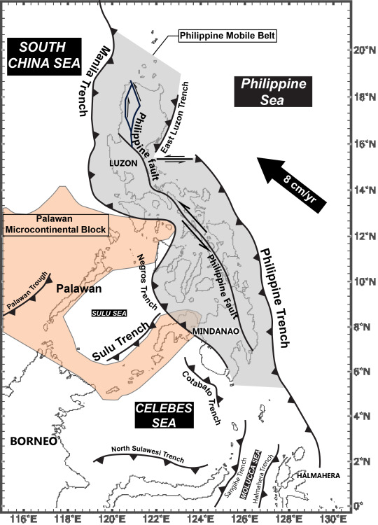
Reading up on the geology of the Philippines and it's got me 😱
Like "oh the subduction zone off the west coast of the Americas that result in what you call the Ring of Fire? Yeah we have TWO OF THEM pointed right at each other at point blank. With a slip strike fault (e.g. San Andreas) straight down the middle for good measure."
Some real Fifth Season energy from Wikipedia: "Active subduction disturbs the Earth's crust, leading to volcanic activity, earthquakes, and tsunamis, making the Philippines one of the most geologically hazard-prone regions on Earth."
30 notes
·
View notes
Text
The OG Saga of the Super-Sons represents an interesting period of comic book history. The Bronze Age of Comics is generally agreed to have started somewhere between 1970 (when Green Lantern/Green Arrow started up and Jack Kirby left Marvel to start the New Gods at DC) and 1973 (when the death of Gwen Stacy happened over in Spider-man).
The first issue of the Super-Sons saga hits right in the middle of that -- cover date of Jan 1973, which means it would've been on the stands towards the end of '72, with most of the other stories coming out sporadically in World's Finest until 76. It means their adventures wind up having this interesting mix between Silver Age goofiness and the Bronze Age return to darker storylines and social issues.
So in Issue 1 you've got Clark snapping the San Andreas fault like a bedsheet so the boys can test their stuff against a dying crime boss without actually risking anyone living in the city they're playing in thanks to the time paradox (it makes... just as much sense in context.)
In Issue 2 they effectively stumble into a Twilight Zone episode, visiting a small town with a mysterious secret that turns out to involve a murdered alien family, a misunderstanding involving their spacecraft, and cryogenic freezing.
And then issue 3 is this almost down-to-earth drama about a third boy who discovers he's adopted, so he abandons the noble but poor man who raised him to instead live the high life with his rich birth father, only to get a rude awakening when he learns that the South American emerald mine those riches come from is essentially a colonialist slave camp, which the Super Sons naturally help bust.
And the fourth issue?

...oh.

Oh dear. This won't end well.
4 notes
·
View notes
Text

Rock Facts: Fun With Faults
I actually had this post in mind a couple of weeks ago, but then I got up on the 9th and decided that it... might be considered in poor taste that particular weekend. So I gave it a little while.
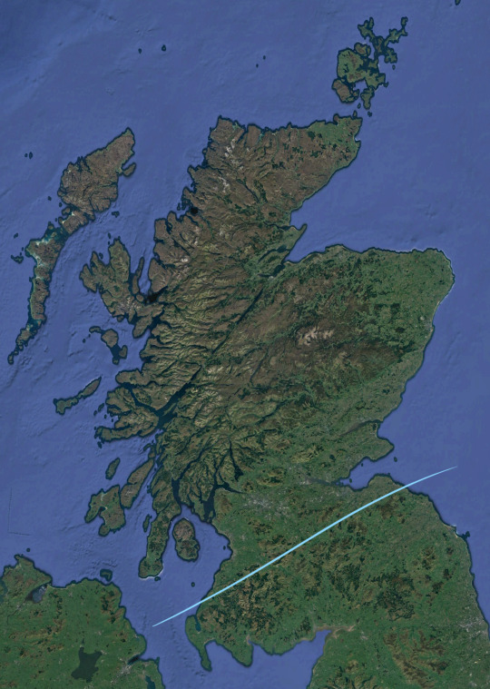
So, when you think of seismically-active regions, you generally think of places like California and Japan; Scotland is not very high on the list of places that spring immediately to mind. In fact, we get quite a lot of earth tremors every year! It's just that fortunately most of them are small enough that nobody who isn't staring intently at a seismograph at the time even notices, and most of the bigger ones are on the scale of 'huh, that must've been a big truck that just went past'.
There are three main fault zones (and a lot of smaller ones) running through Scotland to cause these little quakes, and interestingly you can see them pretty clearly on the satellite picture above.
The first I'll highlight is the Great Glen Fault.

It's a strike-slip fault (goes sideways) like San Andreas in California, though thankfully much less active, and runs from the Isle of Mull in the southwest to the Moray Firth in the northeast. The fault actually extends further in either direction, down through the north of Ireland and up towards Shetland, but those regions have different names so we won't worry about them not.
The fault leaves a particular line of weakness in the bedrock along the Great Glen that's been further scoured out by glacial activity; this is why Loch Ness is as deep as it is. It's not the biggest loch by surface area (that would be Loch Lomond) and it's not the deepest (Loch Morar), but the two combined make it easily the biggest by volume. As in, 'contains more freshwater than all the lakes in England and Wales combined'.
The Kessock Bridge, which you'll cross to drive north out of Inverness, is engineered to account for movement on the fault.
Secondly, the Southern Uplands Fault.
This one cuts across from South Ayrshire in the southeast to Dunbar in East Lothian. I actually don't know very much about it, but it's the divider between the gentle lowlands of the Central Belt and the higher ground of the Southern Uplands. Nice part of the country, actually.
Finally, the one I find most interesting: the Highland Boundary Fault.
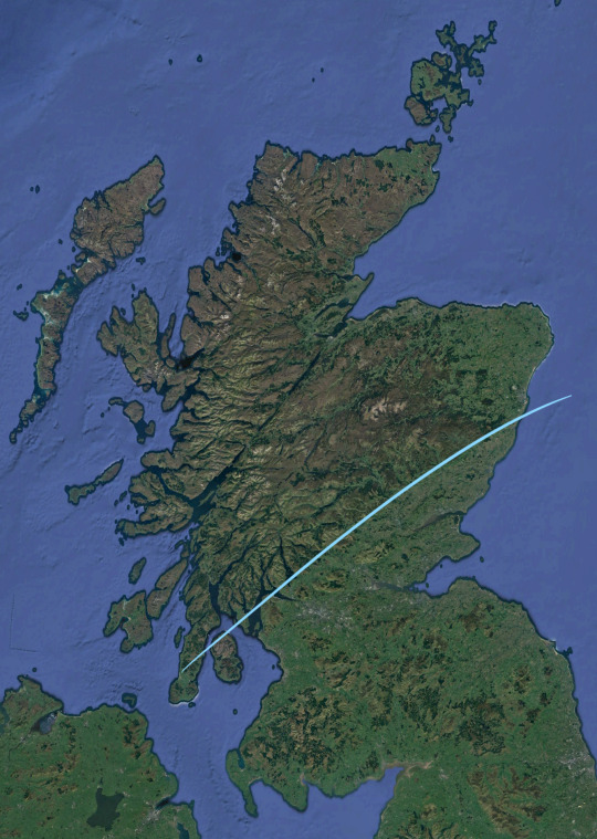
Look back up at the unedited sat pic; you can see that it makes a very, very clear line from the Isle of Arran in the southwest, up across the southern end of Loch Lomond and through Perthshire, until it hits the coast again at Stonehaven just south of Aberdeen. The political and cultural dividers between the Highlands and the Lowlands are more complicated and outwith the scope of this post, but geologically? This is the boundary.
On the way, the fault passes through the small town of Comrie to the west of Perth, where it shoogles enough to make Comrie the most seismically-active place in Britain and give it the nickname of the Shaky Toun. It's also the site of the first modern seismometer, which was kept in the small building known as Earthquake House. Earthquake House is still a seismic observatory, though the equipment is a bit better these days.
6 notes
·
View notes
Note
If you could repair or create a faultline anywhere on the planet, where would you?
hmmm. As an Angeleno, my first thought was mending the San Andreas, but I think that living in fear of The Big One™ is an important part of our moral fibre. This is why Los Angeles is better than New York.
I also have a very in-depth worldbuilding alt-geo/alt-hist project set on a made-up volcanic archipelago in the South China Sea, so I’m inclined to make the meeting of the Eurasian, Yangtze, and Sunda plates a bit more interesting by adding another fault line somewhere in there, but sadly opening another rift does not an eighteen-hundred-year-old Sino-Roman colony make :(
I think the real answer is to open a nice rift zone in the North American Interior Plains, a line running from around the Sabine River on the Gulf Coast and up into the Arctic Ocean north of Great Bear Lake, with the most rifty parts running through central Saskatchewan, the Dakotas, Nebraska, Kansas, and ArkLaTex. This is because I think adding earthquakes to the unique combination of weather events that occur only in the Prairies/Midwest would be good enrichment for them, though I fear it would make their hubris only grow.
But we would get some more cool freshwater lakes, so I think it’s a fair trade off. As long as they stay out of LA and Montréal, at least, but I think that’s pretty easy to accomplish (they would melt + ils ont peur des français).
3 notes
·
View notes
Video
youtube
California Officials EVACUATED The San Andreas Fault Zone On The Brink O...
0 notes
Text
We Know Where The Next Big Earthquakes Will Happen — But Not When
Scientists Have Drastically Improved Our Understanding of Seismic Events. Here are Eight Things to Know.
— By Umair Irfan | April 5, 2024

A building lurches in Taiwan after a Magnitude 7.4 Earthquake Rocked the Island. Sam Yeh/AFP Via Getty Images
Earthquakes Can Strike When and Where We Least Expect Them — as residents in the New York City and New Jersey area discovered on Friday morning, when an estimated magnitude 4.8 quake hit at 10:23 am Eastern time.
The quake’s epicenter was in Lebanon, New Jersey, some 50 miles west of Manhattan, though shaking was reportedly felt as far south as Philadelphia and as far north as Boston. As of late Friday morning, there were no reports of serious damage.
Earthquakes on the East Coast are rare, but not unheard of. On August 23, 2011, a magnitude 5.8 quake struck nearly Mineral, Virginia, causing an estimated $200 to $300 million in damages. That quake occurred in the Central Virginia Seismic Zone.
In part because seismic waves can travel further in East Coast sediment than along the much more seismically-active West Coast, and because the region is so densely populated, scientists at the US Geological Survey estimated that the 2011 quake was likely felt by more people than any other quake in North American history.
Around the world, quakes remain a potent, deadly threat. The largest earthquakes in nearly 25 years rocked Taiwan on Wednesday morning, killing at least nine people and injuring hundreds more. The magnitude 7.4 quake led to a series of aftershocks, the largest of which reached magnitude 6.4. A series of earthquakes reaching magnitude 6.3 struck Afghanistan last year, leading to more than 2,400 deaths. A magnitude 6.8 earthquake rocked Morocco last September, the largest earthquake to hit the country in at least 120 years. Officials reported that it killed more than 2,900 people.
The Mediterranean region is also seismically active, according to the US Geological Survey, though such strong earthquakes are rare in North Africa. Quakes are more common in places like Turkey, where two major fault lines cross and trigger shocks on a regular basis. A huge magnitude 7.8 earthquake rattled across Turkey and Syria in 2023 and another quake with a magnitude of 7.5 rocked the region a few hours later. The quakes killed more than 50,000 people and toppled more than 5,600 buildings in the region.
While scientists have drastically improved their understanding of where earthquakes are likely to occur, forecasting when one will occur is still impractical. The rumbling earth can easily catch people off-guard, worsening the ensuing death and destruction.
In light of the recent disasters, here’s a refresher on earthquakes, along with some of the latest science on measuring and predicting them.
1) The Basics On What Causes Earthquakes
An earthquake occurs when massive blocks of the earth’s crust suddenly move past each other. These blocks, called tectonic plates, lie on top of the earth’s mantle, a layer that behaves like a very slow-moving liquid over millions of years.
That means tectonic plates jostle each other over time. They can also slide on top of each other, a phenomenon called subduction. The places on the planet where one plate meets another are the most prone to earthquakes. The specific surfaces where parcels of earth slip past each other are called faults. As plates move, pressure builds up across their boundaries, while friction holds them in place. When the former overwhelms the latter, the earth shakes as the pent-up energy dissipates.
Scientists understand these kinds of earthquakes well, which include those stemming from the San Andreas Fault in California and the East Anatolian Fault in Turkey. However, earthquakes can also occur within tectonic plates, as pressure along their edges cause deformations in the middle. These risks are harder to detect and measure.
“Our understanding of these within-plate earthquakes is not as good,” said Stanford University geophysics professor Greg Beroza. An earthquake within a tectonic plate has fewer telltale signs than those that occur at fault lines, he added.
2) The Richter Scale Isn’t The Only Measurement Game in Town Anymore
The Richter scale, developed by Charles Richter in 1935 to measure quakes in Southern California, has fallen out of fashion.
It uses a logarithmic scale, rather than a linear scale, to account for the fact that there is such a huge difference between the tiniest tremors and tower-toppling temblors. On a logarithmic scale, a magnitude 7 earthquake is 10 times more intense than a magnitude 6 and 100 times more intense than a magnitude 5.
The Richter scale is actually measuring the peak amplitude of seismic waves, making it an indirect estimate of the earthquake itself. So if an earthquake is like a rock dropped in a pond, the Richter scale is measuring the height of the largest wave, not the size of the rock nor the extent of the ripples.
And in the case of an earthquake, the ripples aren’t traveling through a homogenous medium like water, but through solid rock that comes in different shapes, sizes, densities, and arrangements. Solid rock also supports multiple kinds of waves. (Some geologic structures can dampen big earthquakes while others can amplify lesser tremors.)
While Richter’s scale, calibrated to Southern California, was useful to compare earthquakes at the time, it provides an incomplete picture of risks and loses accuracy for stronger events. It also misses some of the nuances of other earthquake-prone regions in the world, and it isn’t all that useful for people trying to build structures to withstand them.
“We can’t use that in our design calculations,” said Steven McCabe, leader of the earthquake engineering group at the National Institute of Standards and Technology. “We deal in displacements.”
Displacement, or how much the ground actually moves, is one alternative way to describe earthquakes. Another is the moment magnitude scale. It accounts for multiple types of seismic waves, drawing on more precise instruments and better computing to provide a reliable measuring stick to compare seismic events.
When you hear about an earthquake’s magnitude in the news — like Turkey’s recent magnitude 7.8 quake — moment magnitude is usually the scale being used.
But this is still a proxy for the size of the earthquake. And with only indirect measurements, it can take up to a year to decipher the scale of an event, like the 2004 Indian Ocean earthquake, said Marine Denolle, an earthquake researcher at Harvard University.
“We prefer to use peak ground acceleration,” she said. This is a metric that measures how the speed and direction of the ground changes and has proven the most useful for engineers.
So, yes, earthquake scales have gotten a lot more complicated and specific over time. But that’s also helped scientists and engineers take much more precise measurements — which makes a big difference in planning for them.
3) We Can’t Really Anticipate Them All That Well
Predicting earthquakes is a touchy issue for scientists, in part because it has long been a game of con artists and pseudoscientists who claim to be able to forecast earthquakes. (Their declarations have, of course, withered under scrutiny.)
Scientists do have a good sense of where earthquakes could happen. Using historical records and geologic measurements, they can highlight potential seismic hot spots and the kinds of tremors they face. (You can check out the US Geological Survey’s interactive map of fault lines and NOAA’s interactive map of seismic events.)
As for when quakes will hit, that’s still murky.
“Lots of seismologists have worked on that problem for many decades. We’re not predicting earthquakes in the short term,” said Beroza. “That requires us to know all kinds of information we don’t have.”
It’s difficult to figure out when an earthquake will occur, since the forces that cause them happen slowly over a vast area but are dispersed rapidly over a narrow region. What’s amazing is that forces built up across continents over millions of years can hammer cities in minutes.
Forecasting earthquakes would require high-resolution measurements deep underground over the course of decades, if not longer, coupled with sophisticated simulations. And even then, it’s unlikely to yield an hour’s worth of lead time. So there are ultimately too many variables at play and too few tools to analyze them in a meaningful way.
Some research shows that foreshocks can precede a larger earthquake, but it’s difficult to distinguish them from the hundreds of smaller earthquakes that occur on a regular basis.
On shorter time scales, texts and tweets can actually race ahead of seismic waves. In the 2011 Tohoku earthquake in Japan, for example, warnings from near the epicenter reached Tokyo 232 miles away, buying residents about a minute of warning time.
Many countries are now setting up warning systems to harness modern electronic communications to detect tremors and transmit alerts ahead of shaking ground, buying a few precious minutes to seek shelter.
Meanwhile, after a large earthquake, aftershocks often rock the afflicted region. “If we just had a big one, we know there will be smaller ones soon,” Denolle said.
When it comes to prediction, researchers understandably want to make sure they don’t overpromise and underdeliver, especially when thousands of lives and billions of dollars in damages are at stake. But even this caution has had consequences.
In 2012, six Italian scientists were sentenced to six years in prison for accurately saying the risks of a large earthquake in the town of L’Aquila were low after a small cluster of earthquakes struck the region in 2009. Six days after the scientists convened to assess the risk, a large quake struck and killed 309 people. Those convictions were later overturned and the ordeal has become a case study for how scientists convey uncertainty and risk to the public.
4) Sorry, Your Pets Can’t Predict Earthquakes Either
Reports of animals acting strange ahead of earthquakes date back to ancient Greece. But a useful pattern remains elusive. Feathered and furry forecasters emerge every time there’s an earthquake and there’s a cute animal to photograph, but this phenomenon is largely confirmation bias. Animals do weird things (by our standards) all the time and we don’t attach any significance to them until an earthquake happens.
“On any given day, there will be hundreds of pets doing things they’ve never done before and have never done afterward,” Beroza said. Bottom line: Don’t wait for weird animal behavior to signal that an earthquake is coming.
5) Some Earthquakes are Definitely Human-made
The gargantuan expansion of hydraulic fracturing across the United States has left an earthquake epidemic in its wake. It’s not the actual fracturing of shale rock that leads to tremors, but the injection of millions of gallons of wastewater underground.
Scientists say the injected water makes it easier for rocks to slide past each other. “When you inject fluid, you lubricate faults,” Denolle said.
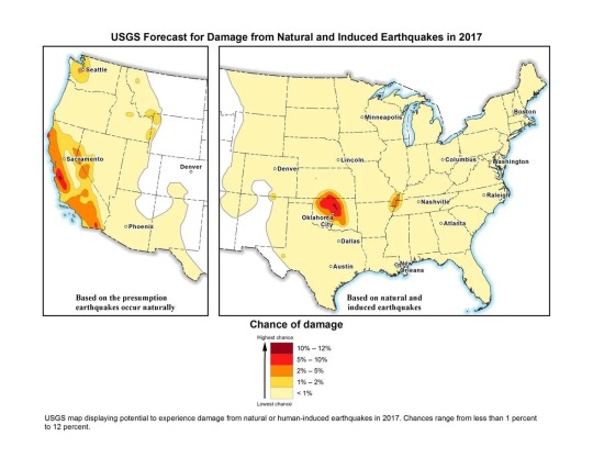
US Geological Survey map of natural and induced earthquake risk in 2017. USGS
The US Geological Survey calls these “induced earthquakes” and reported that in Oklahoma, the number of earthquakes surged to 2,500 in 2014, 4,000 in 2015, and 2,500 in 2016.
“The decline in 2016 may be due in part to injection restrictions implemented by the state officials,” the USGS wrote in a release. “Of the earthquakes last year, 21 were greater than magnitude 4.0 and three were greater than magnitude 5.0.”
This is up from an average of two earthquakes per year of magnitude 2.7 or greater between 1980 and 2000. (“Natural” earthquakes, on the other hand, are not becoming more frequent, according to Beroza.)
Humans are causing earthquakes another way, too: Rapidly drawing water from underground reservoirs has also been shown to cause quakes in cities like Jakarta, Denolle said.
6) Climate Change Could Have a Tiny Effect on Earthquakes
In general, scientists haven’t measured any effect on earthquakes from climate change. But they’re not ruling out the possibility.
As average temperatures rise, massive ice sheets are melting, shifting billions of tons of water from exposed land into the ocean and allowing land masses to rebound. That global rebalancing could have seismic consequences, but signals haven’t emerged yet.
“What might occur is enough ice melts that could unload the crust,” Beroza said, but added there is no evidence for this, nor for which parts of the world will reveal a signal. Denolle agreed that this could be a mechanism, but if there is any impact from climate change on earthquakes, she says she suspects it will be very small.
7) We’ve Gotten Better at Reducing Earthquake Risks and Saving Lives
About 90 percent of the world’s earthquakes occur in the Ring of Fire, the region around the Pacific Ocean running through places like the Philippines, Japan, Alaska, California, Mexico, and Chile. The ring is also home to three-quarters of all active volcanoes.

Most of the planet’s earthquakes occur along the Pacific rim in a region known as the Ring of Fire. Javier Zarracina/Vox
Mexico is an especially interesting case study. The country sits on top of three tectonic plates, making it seismically active. In 1985, an earthquake struck the capital, killing more than 10,000. Denolle noted that the geology of the region makes it so that tremors from nearby areas are channeled toward Mexico City, making any seismic activity a threat.
The Mexican capital is built on the site of the ancient Aztec city of Tenochtitlan, an island in the middle of a lake. The dry lakebed that is now the foundation of the modern metropolis amplifies shaking from earthquakes.
The 1985 earthquake originated closer to the surface, and the seismic waves it produced had a relatively long time between peaks and valleys. This low-frequency vibration sends skyscrapers swaying, according to Denolle. “The recent earthquakes were deeper, so they had a higher frequency,” she said.
The biggest factor in preventing deaths from earthquakes is building codes. Designing buildings to move with the earth while remaining standing can save thousands of lives, but putting them into practice can be expensive and frequently becomes a political issue.
“Ultimately, that information has got to get implemented, and you can pretty much get that implemented in new construction,” McCabe said. “The trickier problem is existing buildings and older stock.”
Earthquake-prone countries know this well: Japan has been aggressive about updating its building codes regularly to withstand earthquakes. The revised standards have in part fueled Japan’s construction boom despite its declining population.
Mexico has also raised standards for new construction. Laws enacted after the 1985 earthquake required builders to account for the soft lakebed soil in the capital and tolerate some degree of movement.
Meanwhile, Iran has gone through several versions of its national building standards for earthquake resilience. And Alaska has been developing earthquake damage mitigation strategies and response plans for years.
But codes are not always enforced, and the new rules only apply to new buildings. A school that collapsed in a 2017 Mexico City earthquake apparently was an older building that was not earthquake-resistant. And because the more recent earthquakes in Mexico shook the ground in a different way, even some of the buildings that survived the 1985 earthquake collapsed after tremors in 2017.
In countries like Iran, there is a wide gulf between how buildings are constructed in cities versus the countryside. More than a quarter of the country’s population lives in rural areas, where homes are built using traditional materials like mud bricks and stone rather than reinforced concrete and steel. This is a big part of why casualties are so high when earthquakes strike remote parts of the country.
The biggest risks fall to countries that don’t have a major earthquake in living memory and therefore haven’t prepared for them, or don’t have the resources to do so. A lack of a unified building code led to many of the more than 150,000 deaths in Haiti stemming from the 2010 magnitude 7.0 earthquake.
8) The Big One Really is Coming to the United States (Someday)
The really big one you keep hearing about is real.
The New Yorker won a Pulitzer Prize in 2015 for its reporting on the potential for a massive earthquake that would rock the Pacific Northwest — “the worst natural disaster in the history of North America,” which would impact 7 million people and span a region covering 140,000 square miles.
The potential quake could reach a magnitude between 8.7 and 9.2, bigger than the largest expected earthquake from the San Andreas Fault, which scientists expect to top out at magnitude 8.2.
Large earthquakes are also in store for Japan, New Zealand, and other parts of the Ring of Fire. We don’t know when these earthquakes will rock us; we just have a rough estimate of the average time between them, which changes from region to region.
“In the business, we’ve been talking about that [Pacific Northwest] scenario for decades,” Beroza said. “I wouldn’t say we’re overdue, but it could happen at any time.”
“It is a threat,” echoed Denolle. “We forget about this threat because we have not had an earthquake there for a while.” “A while” means more than 300 years.
So while California has long been steeling itself for big earthquakes with building codes and disaster planning, the Pacific Northwest may be caught off guard, though the author of the New Yorker piece, Kathryn Schulz, helpfully provided a guide to prepare.
— Umair Irfan is a correspondent at Vox writing about climate change, Covid-19, and energy policy. Irfan is also a regular contributor to the radio program Science Friday. Prior to Vox, he was a reporter for ClimateWire at E&E News.
0 notes
Text
0 notes
Text
Movement of Earth
The Earth's crust is not a solid, continuous surface but a dynamic and ever-changing mosaic of large, rigid plates known as tectonic plates. These plates are constantly in motion, drifting atop the semi-fluid asthenosphere, a layer of the Earth's mantle. This fascinating phenomenon is known as plate tectonics, and it plays a crucial role in shaping the Earth's landscape, causing earthquakes, forming mountains, and contributing to the distribution of land and oceanic features.
Plate Tectonics
Plate tectonics is a geological theory that revolutionized our understanding of the Earth's structure and dynamics. The theory was proposed in the mid-20th century, consolidating various evidence from geological and geophysical studies. According to this theory, the Earth's lithosphere, which is the rigid outer layer of the Earth, is divided into several large and some smaller tectonic plates. These plates move horizontally and independently of each other, causing them to interact at their boundaries.
Types of Plate Boundaries
The interaction of tectonic plates mainly occurs at three types of plate boundaries:
Divergent Boundaries: At divergent boundaries, tectonic plates move away from each other. This movement leads to the upwelling of magma from the mantle, creating new crust and widening ocean basins. One of the most famous divergent boundaries is the Mid-Atlantic Ridge, where the Eurasian and North American plates are moving apart, causing seafloor spreading.
Convergent Boundaries: Convergent boundaries are locations where tectonic plates move toward each other. When two plates collide, one may be forced beneath the other in a process known as subduction. Subduction zones often lead to deep ocean trenches and volcanic arcs forming. An example of a convergent boundary is the collision between the Indo-Australian Plate and the Eurasian Plate, resulting in the formation of the Himalayan mountain range.
Transform Plate Boundaries: Tectonic plates slide past each other horizontally at transform boundaries. The movement along these boundaries is responsible for earthquakes. The San Andreas Fault in California is a well-known transform boundary where the Pacific and North American plates are sliding past each other.
Driving Forces of Plate Tectonics
Several factors contribute to the movement of tectonic plates. The main driving forces behind plate tectonics are:
Mantle Convection: Heat from the Earth's interior drives convection currents in the semi-fluid asthenosphere. These currents play a significant role in pushing and dragging the overlying tectonic plates, influencing their movement.
Slab Pull: Subduction zones at convergent boundaries involve sinking a denser tectonic plate into the mantle. The sinking slab's downward pull contributes to the plates' motion.
Ridge Push: At divergent boundaries, the newly formed oceanic crust pushes the plates apart due to its elevated position at mid-ocean ridges.
Result of Movement of Earth's Plate
Tectonic plate movement causes folding and faulting of the Earth's crust, forming mountains like the Himalayas through folding and rift valleys like the East African Rift Valley through faulting. The crust's layers, called strata, result from the compression of materials eroded from pre-existing rocks. Accumulated pressure from plate movements can eventually release energy.
Folding
When the crust of the Earth is folded, it is strained and pushed, resulting in a variety of characteristics commonly evident when gazing at a rock face. The anticline, which is high; the syncline, which is low; and the limbs, also referred to as the "arms" of the folds, make up a fold.
The different types of folds include:
Monoclines, where the layers move in the same direction.
Symmetrical folds, where both arms have the same slope.
Asymmetric folds, where one arm has a steeper slope than the other.
Overfolds, where the arms have slightly turned over.
Faulting
Faulting is a phenomenon that occurs as a result of the significant strain that the folding of layers exerts on plates. The tension or compression pressure in the fold, which can build along a fault line, results in a fracture. This defect is capable of moving both vertically and horizontally. Such a fault line is the San Andreas Fault Line in the United States.
The three primary forms of faulting are normal faulting, reverse faulting, and rip faulting. They result from the plates' divergence, convergence, and transverse motion. In conclusion, the planet's crust is deformed and reorganized by the folding and faulting of the Earth's surface brought on by compression, tension, and shearing induced by the movement of Earth's plates.
Plate Tectonics and Global Change
Plate tectonics have significant implications for climate change and the evolution of life on Earth. The movement of continents affects ocean currents, which, in turn, influence climate patterns. Additionally, tectonic activity can trigger volcanic eruptions and release greenhouse gases into the atmosphere, affecting global temperatures over geological time scales.
0 notes
Text
Hunter x Hunter "Modern Geology"
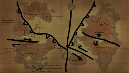
The first thing to talk about is the fact that the map is predominately upside down. I believe this is just because of a magnetic reversal, as in, the continents didn’t all move, just where north is pointing, within the timeframe of 49 million years this is entirely possible.
Next, overall we can see we are in a period of warming, by looking at locations like the Great Lakes which are all completely flooded into one lake and Florida is half underwater (thank goodness).
Moving into Hazards that would be experienced by each country/region.
The first thing to mention is the areas that are experiencing subduction (which cause the most hazards overall)
The coasts of The Federation of Ochima, Kakin Kingdom, and Azia would all experience Tsunamis, high intensity earthquakes, and stratavolcanoes (think hazards experienced in Japan) The coasts of Kukan’yu Kingdom would also experience similar hazards due to different subduction zone.
Between Kakin and Ochima there is the beginnings of a new ocean forming between them (think of the East African Rift) Hazards would include Bimodal volcanism, which means some volcanoes would behave very similarly to Hawaii and others would behave more like Iceland. There would also be frequent shallow earthquakes.
Zones that are shearing (or sliding beside each other) are between Ochima and Begerosse and between United States of Saherta and Kukan’yu. The only notable hazard for this would be local large earthquakes very similar to the Anatolian fault and the San Andreas Fault.
The last thing to note is the island in the middle of the ocean that has a circular river in it. More than likely this island is much smaller than it appears on the map much like Greenland and that this is a volcanic island that, during its last eruption, collapsed in onto itself and created that looking lake. This is something that occurs in the real world often and is more than likely supposed to represent the future of Iceland. However, it also could be the sight of a large meteor impact.

These are some examples of impact craters

This is an example of a collapsed caldera.
3 notes
·
View notes
Text
Bubble bubble more earthquake trouble? Geoscientists study Alaskas Denali fault
“It’s a big, sweeping fault and the source of a magnitude 7.9 earthquake in 2002, that ruptured more than 200 miles of the Denali Fault, along with the Totschunda Fault to the east, causing significant damage to remote villages and central Alaska’s infrastructure,” says Utah State University geochemist Dennis Newell.
Understanding the restless fault’s mantle-to-crust connections provides critical information for understanding the lithospheric-scale fault’s seismic cycle, says Newell, associate professor in USU’s Department of Geosciences. He and colleagues Jeff Benowitz, an Alaska-based geochronologist, Sean Regan of the University of Alaska Fairbanks, and doctoral candidate Coleman Hiett of USU, collected and analyzed helium and carbon isotopic data from springs along a nearly 250-mile segment of the fault and published their findings, “Roadblocks and Speed Limits: Mantle-to-Surface Volatile Flux in the Lithospheric Scale Denali Fault, Alaska,” in the June 1, 2023 print issue of the journal Geology.
The research was funded by a one-year National Science Foundation Early-Concept Grant for Exploratory Research (EAGER) awarded to Newell and Regan in 2020.
“Active strike-slip faults like Denali have three-dimensional geometries with possible deep conduit connections below the Earth’s surface,” Newell says. “But we don’t know much about how and if these connections are maintained.”
To examine these possible deep connections, Newell and Regan sampled 12 springs along the Denali and Totschunda Faults, by way of helicopter and on foot, to the remote, mountainous regions of Alaska’s interior.
“Helium-3, a rare isotope of helium gas, in springs is a good indicator of whether or not an area has a connection to the Earth’s mantle,” Newell says. “Warm, bubbling springs west of the 2002 earthquake rupture, along the Cantwell segment of the Denali Fault, have a strong helium-3 signature, indicating intact connections to the mantle. In contrast, springs along the ruptured fault segment only have atmospheric gases, suggesting a ‘roadblock’ preventing the flow of mantle helium to the surface.”
These observations, he says, have implications for how groundwater pathways along the fault are changed by earthquakes, and the timescales on which they heal.
“The last major earthquake on the Cantwell segment was 400 years ago, and the helium data suggest those mantel connections have been reestablished,” Newell says. “These bubbling springs are indicative of the possibility of a future large destructive earthquake along the Denali Fault segment near Denali National Park, which receives some 600,000 visitors each summer.”
The geoscientists also seek data on how fast helium can move from the mantle to the crust along active faults.
“That’s the ‘speed limit’ part of our research,” Newell says. “This is important as it reveals mantle-to-surface volatile flux and how fluid pressure gradients may impact fault strength and seismicity along the fault.”
The fault’s mantle fluid flow rates fall in the range observed for the world’s other major and active strike-slip faults that form plate boundaries, he says, including California’s San Andreas Fault and Turkey’s North Anatolian Fault Zone. These types of faults host large, devastating earthquakes, such as February 2023’s deadly earthquake on the East Anatolia Fault, which caused widespread destruction in Turkey and Syria.
“Quantifying crust-to-mantle connections along major strike-slip faults is critical for understanding linkages between deep fluid flow, seismicity and fault healing,” Newell says.
0 notes
Text
Could California Experience A Disastrous Earthquake Like Turkey And Syria?
The Carrizo Plain in eastern San Luis Obispo County contains the most strikingly graphic portion of … [+] the San Andreas Fault.
getty
The magnitude 7.8 and 6.7 earthquakes that killed – by current count – more than 25,000 people in Turkey and Syria one week ago were produced by geological conditions found also in California.
Both areas are recognized as earthquake-prone zones as they sit above…

View On WordPress
0 notes
Video
youtube
Earthquake! The USA's Coming Big One!
Here's the link to our video.. "Coming West Coast Earthquake & Tsunami - Cascadia Subduction Zone Disaster" https://youtu.be/Vc6Nh0PM8JM - Seismologists foresee a soon-to-come devastating US and Canadian West Coast Earthquake, a magnitude 9.0 or greater! The Cascadia Subduction Zone Earthquake will also produce a colossal tsunami, as the quake unleashes 20 times the power that the San Andreas Fault could generate!
Our website.. GloryToGodVideos.com
#turkey earthquake#syria earthquake#turkey syria earthquake#earthquake the big one#earthquake west coast USA
1 note
·
View note
Text
The Hot Spot, Part 1
The Hot Spot, Part 1
The great San Francisco earthquake of 1906 may be history, but the cause of the quake — movement along the San Andreas Fault — still occurs all up and down the coast of Northern California. Sonoma County’s Hot Spot is only one of several faults along the San Andreas Fault Zone. I’ve found it nearly impossible to find much information about The Hot Spot online, although it first came to my notice…

View On WordPress
0 notes
Photo
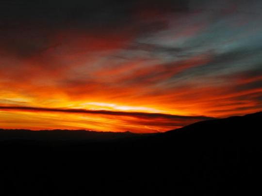
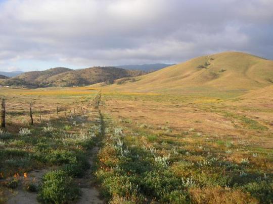
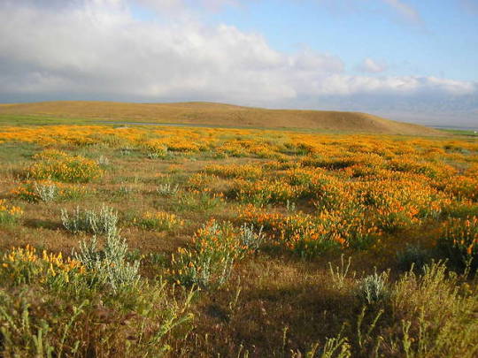
David Hough hiked the PCT in sections between 2001- 2013 and is about one third of the way through a second section-hike of the entire trail. He just recently finished California’s Section E . . . an often maligned section that includes the California Aqueduct walk and can often be incredibly hot and dry. But, if hikers hit it just right, the wildflower bloom can be spectacular. As David said about his walk this year, “I was once again impressed by the wildflowers and green grass (and brush) and relatively abundant water, and during the week, nobody here except us PCT hikers.”
Over the past month we have highlighted a number of the unique features of Section E -- the historic Rock Inn near Lake Hughes, the incomparable Casa de Luna, the site of the St. Francis Dam collapse, and, if you hit the section just right . . . the amazing display of flowers. Here are three of David’s photos (from top to bottom): an amazing sunset from upper Bouquet Canyon, the trail south from Hiker Town toward the San Andreas Fault Zone and Libre Mountain, and a carpet of California poppies.
Indeed, every section of the PCT has its day.
.
3 notes
·
View notes
Last Seen Blogs

arkaitzart
Arkaitz Art

2024barakablog
Baraka 2024 Arqui

prairiefirewitch
PRAIRIE FIRE WITCH

fung1rl
kate

tatexbrandt
worth / less