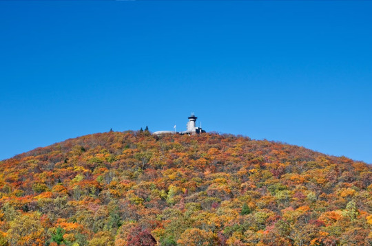
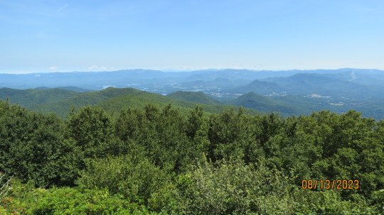
#brasstown bald
Text

She wanted to see the view too
#alaskan malamute#malamute#north Georgia#appalachia#appalachian mountains#brasstown bald#mountains#fall#autumn#dog#dogs#puppy#puppers#doggo#my photos
38 notes
·
View notes
Text
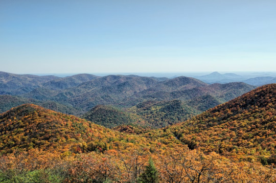
Brasstown Bald, Blue Ridge Mountains, Georgia, USA
James Morden
#Brasstown Bald#Blue Ridge Mountains#Georgia#USA#US#GANature#United States of America#United States#North America
0 notes
Text
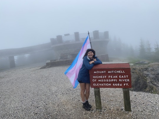
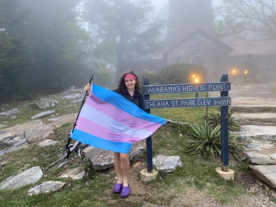
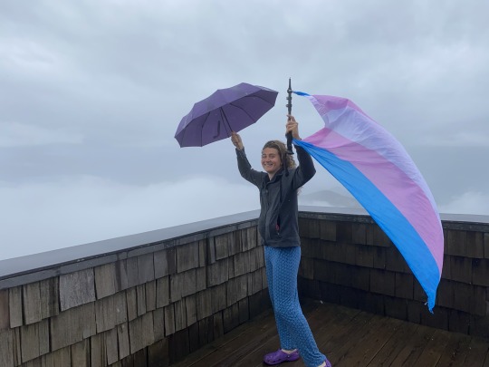
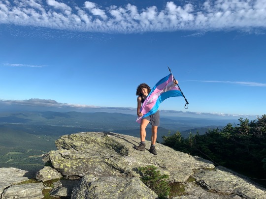
Here's some photos of me taking a trans pride flag up the tallest mountain in ten different states: North Carolina, Alabama, Tennessee, Georgia, Kentucky, Virginia, New Hampshire, New York, Vermont, and Maine!!!
Attakulla, NC - May 18th, 2023:
Cheaha, AL - April 26th, 2023:
Kuwahi, TN - April 5th, 2023:

Brasstown Bald, GA - April 26th, 2023:
Black, KY - May 1st, 2023:

Rogers, VA - May 5th, 2023:

Agiocochook, NH - July 10th, 2022:

Tahawus, NY - July 17th, 2022:

Mozdebiwajo, VT - August th, 2022:
Katahdin, ME - September 7th, 2022:

#lol flag time#trans#trans pride#queer#queer pride#pride#pride flag#lgbtq#lgbtq pride#lgbt pride#transgender#transgender pride#hiking#peakbagging
1K notes
·
View notes
Text
brasstown bald, highest point in georgia
14 notes
·
View notes
Photo
Northern View from Brasstown Bald, Georgia US (2939×3004) OC
16 notes
·
View notes
Note
First time I've seen a post mentioning Forsyth in the wild Ever. I grew up off the highway somewhere in-between Gainesville, Dawsonville, and Chestatee. I drowned in Lainer twice in one summer. My mom had to call poison control multiple halloweens in a row because my brother wouldn't stop chewing active glowsticks in the dark (they remembered my mom and we lost household glowstick privileges for years). My sister was tiny when we moved states, but she once ate a Pringle she had just dropped in a target parking lot when she was immunocompromised. I have several hunches ranging from "lakes haunted" to "Kudzu" to "this entire region from the foothills to the Keys is runoff from the Appalachians compounding on reef and peat and clay, something something slow accumulation of mountain rot growing on living bone and steaming fossils."
I need to get out of Chatham more and explore more of our state. My favorite areas to explore when I get out a bit are the mountains past Athens. Going back to Brasstown Bald is a goal of mine!
1 note
·
View note
Text
Petroglyphs: History Carved in Stone
Native Americans had artistic abilities and the urge to demonstrate their skill as much as any members of modern society. In north Georgia, they often demonstrated this by carving various types of symbols and images on large boulders.
The Whale-shaped Stone
The best-known and most spectacular sculptured stone is found on the University of Georgia campus, moved there from its original location in Forsyth County. The fine-grained granite stone, nine feet long and two feet wide, is covered on three sides by numerous characters. Most of the markings are neat, concentric circles, carved deeply and with great precision. Some, eight inches in diameter, are cut to a depth of three-quarters of an inch. across a projecting spine are a series of deep "nut" holes that resembles walnuts in size and shape. These drilled holes are connected by lightly pecked lines. There are other undecipherable and ceremonial symbols found on the stone, and all appear ancient. This whale-shaped stone is no work of nature. It was obviously created by human hands to its present dimensions.
Track Rock Gap
The most famous rock carvings in the state are found at Track Rock Gap, located near Blairsville in the shadowy of Brasstown Bald, Georgia's highest peak. Here are several boulders carved with unusual petroglyphs, including a large number of animal tracks. The original number was close to 100, with twenty-six representations of human feet, including one that was seventeen inches long and reputed to be that of a giant. Others were horse, buffalo, deer, and rabbit tracks, rendered so faithfully that the Cherokee believed they were real prints left by humans and animals in clay that later solidified into stone. Several of the rocks have been stolen, and vandals have cut off the beet symbols from the remaining stones. Those that remain intact, still an impressive lot, are protected by steel cages.
An Expedition to Track Rock Gap
At six a.m., we arrived at the summit of the mountain. As we approached it, the heavens, which before for several days and nights had worn a brightened countenance, began to scowl and threaten; we advanced with a quickened pace to the foot of the rock and spread out our breakfast on the "table of stone," poured out a libation to appease the wrath of Jupiter, drank a few appropriate sentiments, and then, with chisel and hammer, commenced the resurrection of one of the tracks. Notwithstanding, I believe I possess as little superstition as anyone, yet I could not suppress a strange sensation that pervaded me. No sooner did we arrive on the consecrated ground than it began to threaten, and the first stroke of the hammer in the sacrilegious act of raising the track of a human being was responded to by a loud peal of thunder; the clouds continued to thicken condense, attended with the most awful lightning, when soon a deluge of rain was precipitated upon our offending heads. I continued, however, to labor incessantly until I succeeded in disintegrating the impression of a youth's foot, which I carefully wrapped up, and sounded a retreat, still however, looking back . . . in momentary expectation of seeing a legion of exasperated ghosts issuing forth to take their vengeance upon the infidel who would presume to disturb the relics of the dead. As soon as we passed the confines of the mountain, rain ceased, the sun broke out, and all nature resumed her cheerful aspect. -Matthew F. Stevenson, September 3, 1834
1 note
·
View note
Text
#Brasstown Bald #cool breeze #Exploring N.E. Georgia #Amazing views
2 notes
·
View notes
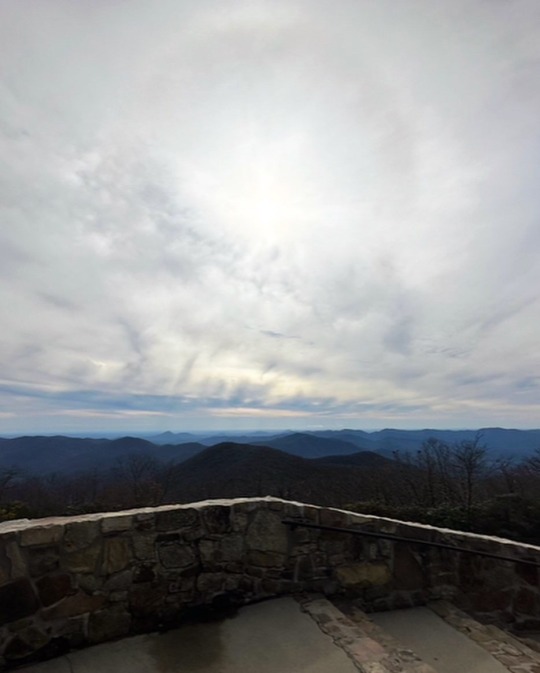
Photo
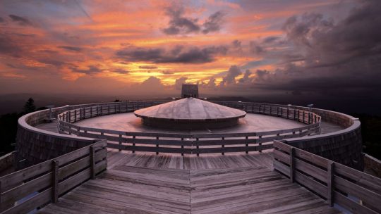
Observatory on the summit of Brasstown Bald Mountain in Georgia, USA
9 notes
·
View notes
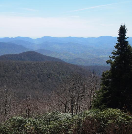
Photo

Arkaquah Trail to Brasstown Bald summit. View from an off-trail overlook midway up the trail. #wandernorthga #vscocam #anydistance — view on Instagram https://ift.tt/y7Krzp5
5 notes
·
View notes
Text
Climate of Georgia

Georgia's climate exhibits a range of characteristics, from oceanic in the extreme northeast to humid subtropical in the rest of the state. Summers tend to be humid and can vary from warm to cool, while winters are typically short and range from mild to cold. The state's location in the southeastern United States, with borders shared with South Carolina, Florida, Alabama, Tennessee, and North Carolina, is influenced by its proximity to the warm waters of the Gulf of Mexico and the Atlantic Ocean.
See Weather Forecast for Georgia today: https://weatherusa.app/georgia
Geographically, Georgia features diverse terrain, from sea level in the southeast to its highest point at Brasstown Bald, reaching 1,458 meters. The state is characterized by various provinces, including the forest-covered mountains and narrow valleys of the Blue Ridge Province in the northeast, flat valleys separated by steep wooded ridges in the Valley and Ridge Province in the northwest, and the steep hilly terrain of the Piedmont Plateau transitioning to rolling hills in the south. The Fall Line marks the boundary between the Piedmont Plateau and the coastal plain, where navigation of major rivers begins. See more: https://weatherusa.app/zip-code/weather-30096
https://weatherusa.app/zip-code/weather-30117 The Coastal Plain itself ranges from rolling hills to level land, featuring marshy and densely wooded areas, with soils ranging from sandy to clay loam supporting much of the state's agriculture.
For visitors, the best time to experience Georgia is during the autumn, characterized by mild, sunny weather, and the driest period of the year. See more: https://weatherusa.app/zip-code/weather-30353 Fall brings pleasant outdoor conditions with colorful landscapes, ideal for activities such as hiking mountain trails, fishing, and hunting. However, the northern hilly areas may experience colder temperatures compared to other regions.
Conversely, the worst time to visit Georgia is during the oppressive heat of summer, particularly in July and August. High temperatures, often exceeding 100°F (37.8°C) in the southern parts of the state, combined with high humidity and frequent thunderstorms, create uncomfortable conditions. The summer season also sees tropical storms moving from the Gulf of Mexico, extending from spring to midsummer, further impacting travel plans. As summer vacations draw crowds, it's advisable to visit Georgia after the summer season ends to avoid the peak heat and tourist influx. See more: https://weatherusa.app/zip-code/weather-30339
https://weatherusa.app/zip-code/weather-30320
https://weatherusa.app/zip-code/weather-30287
Georgia's unique geographic features contribute to its diverse climate patterns. The Caucasian barrier shields the country from cold air intrusions from the north, while warm, moist air from the Black Sea exerts a constant influence, particularly in the western regions.
Western Georgia experiences a humid subtropical, maritime climate, characterized by mild winters and relatively warm, humid summers. In contrast, eastern Georgia displays a range of climates, from moderately humid to a dry subtropical type.
See more: https://weatherusa.app/zip-code/weather-30217 Elevation plays a significant role in shaping climate zones within Georgia. In areas such as the Kolkhida Lowland, elevation gradients result in distinct climatic zones. Below approximately 1,600 to 2,000 feet, a subtropical climate prevails, characterized by mild winters and moderately warm, moist conditions. At higher elevations, around 6,600 to 7,200 feet, temperatures decrease, leading to colder, wetter winters and cooler summers. Beyond 11,200 to 11,500 feet, an alpine climate zone emerges, where snow and ice persist year-round.
In eastern Georgia, where the terrain is more inland, temperatures tend to be lower compared to western regions at similar altitudes. This variation underscores the complex interplay of geographic factors in shaping Georgia's climate, contributing to its diverse array of climatic conditions across the country.
In Western Georgia, heavy rainfall characterizes the climate throughout the year, with annual totals ranging from 40 to 100 inches (1,000 to 2,500 mm). The peak of precipitation occurs during autumn and winter, with the southern Kolkhida region receiving the highest amounts. See more: https://weatherusa.app/zip-code/weather-30233 Humidity levels gradually decrease toward the north and east. Winters in this region are generally mild and warm, with mean January temperatures remaining above freezing (32 °F or 0 °C) in areas below approximately 2,000 to 2,300 feet. Coastal regions experience relatively warm, sunny winter weather, with temperatures averaging around 41 °F (5 °C). Summer temperatures in Western Georgia average around 71 °F (22 °C).
In contrast, Eastern Georgia exhibits a decrease in precipitation with distance from the sea, with plains and foothills receiving between 16 to 28 inches annually, while mountainous areas receive double this amount. The southeastern regions are the driest, with winter being the driest season overall. Rainfall peaks toward the end of spring. July sees the highest lowland temperatures, averaging around 77 °F (25 °C), while average January temperatures range from 32 to 37 °F (0 to 3 °C) across most of the region.
See more: https://weatherusa.app/zip-code/weather-30286
https://weatherusa.app/zip-code/weather-30257
These distinct rainfall patterns and temperature variations reflect the diverse climatic conditions present in different regions of Georgia, shaped by factors such as proximity to the sea, elevation, and geographic features.
0 notes
Text
ประวัติรัฐ จอร์เจีย (Georgia)
จอร์เจีย (Georgia) เป็นรัฐในSoutheasternภูมิภาคของประเทศสหรัฐอเมริกา ชายแดนทางเหนือโดยเทนเนสซีและนอร์ทแคโรไลนา ภาคตะวันออกเฉียงเหนือโดยเซาท์แคโรไลนา ไปทางตะวันออกเฉียงใต้โดยที่มหาสมุทรแอตแลนติก ไปทางทิศใต้โดยฟลอริดา และทางทิศตะวันตกโดยอลาบามา จอร์เจียเป็นวันที่ 24 ที่ใหญ่ที่สุดในพื้นที่และ 8 มีประชากรมากที่สุดของสหรัฐอเมริกา 50 ประชากรในปี 2020 อยู่ที่ 10,711,908 ตามข้อมูลสำนักสำรวจสำมะโนสหรัฐ แอตแลนตาซึ่งเป็นเมืองระดับโลก เป็นทั้งเมืองหลวงของรัฐและเมืองที่ใหญ่ที่สุด พื้นที่มหานครแอตแลนตามีประชากรประมาณกว่า 6 ล้านคนใน 2019 เป็น9 เขตมีประชากรมากที่สุดในประเทศสหรัฐอเมริกาและมีประมาณ 57% ของประชากรทั้งหมดของจอร์เจีย
จอร์เจียก่อตั้งขึ้นในปี ค.ศ. 1733 ในฐานะอาณานิคมของอังกฤษเป็นอาณานิคมสุดท้ายและอยู่ใต้สุดของอาณานิคมทั้งสิบสามแห่งที่จะก่อตั้งขึ้น ตั้งชื่อตามกษัตริย์จอร์จที่สองแห่งสหราชอาณาจักร , อาณานิคมของรัฐจอร์เจียครอบคลุมพื้นที่จาก South Carolina ใต้ไปยังสเปนฟลอริด้าและตะวันตกไปฝรั่งเศสหลุยเซียที่แม่น้ำมิสซิสซิปปี เมื่อวันที่ 2 มกราคม 1788 จอร์เจียกลายเป็นรัฐที่สี่ที่จะให้สัตยาบันรัฐธรรมนูญของสหรัฐอเมริกา จาก 1802 ถึง 1804 จอร์เจียตะวันตกถูกแยกออกเป็นดินแดนมิสซิสซิปปีซึ่งต่อมาได้รับการยอมรับว่าเป็นรัฐแอละแบมาและมิสซิสซิปปีของสหรัฐอเมริกา จอร์เจียประกาศแยกตัวออกจากสหภาพเมื่อวันที่ 19 มกราคม พ.ศ. 2404 และเป็นหนึ่งในเจ็ดรัฐสมาพันธรัฐดั้งเดิม หลังจากสงครามกลางเมืองมันเป็นรัฐสุดท้ายที่จะถูกเรียกคืนไปยังสหภาพ, 15 กรกฏาคม 1870 ในการโพสต์ฟื้นฟูยุคเศรษฐกิจของจอร์เจียก็กลายเป็นกลุ่มของนักการเมืองที่โดดเด่นนักธุรกิจและ นักข่าวนำโดยเฮนรี่ดับบลิวเกรดี้ , ดำเนินการกับ " นิวเซา " ปรัชญาของการประนีประนอมตัดอุตสาหกรรมและสีขาวสุด ในช่วงศตวรรษที่ 20, จอร์เจียหลายสะดุดตาที่สุดมาร์ตินลูเธอร์คิงจูเนียร์เป็นผู้นำที่โดดเด่นในช่วงเคลื่อนไหวสิทธิมนุษยชน ตั้งแต่ปีพ. ศ. 2488 จอร์เจียได้เห็นการเติบโตของประชากรอย่างมากซึ่งเป็นส่วนหนึ่งของปรากฏการณ์Sun Belt ที่กว้างขึ้น ตั้งแต่ปี 2550 ถึงปี 2551 เขตปกครองของจอร์เจีย 14 แห่งติดอันดับหนึ่งใน 100 ประเทศที่เติบโตเร็วที่สุด
จอร์เจียถูกกำหนดโดยความหลากหลายของภูมิประเทศพืชและสัตว์ พื้นที่ทางตอนเหนือสุดของรัฐ ได้แก่เทือกเขาบลูริดจ์ซึ่งเป็นส่วนหนึ่งของระบบภูเขาแอปพาเลเชียนที่ใหญ่กว่า Piedmontที่ราบสูงยื่นออกมาจากบริเวณเชิงเขาของภาคใต้ Blue Ridge กับฤดูใบไม้ร่วงสายเป็นที่สูงชันไปยังที่ราบชายฝั่งกำหนดรัฐภาคใต้ จุดที่สูงที่สุดของจอร์เจียคือBrasstown Baldที่ 4,784 ฟุต (1,458 ม.) เหนือระดับน้ำทะเล ต่ำสุดคือมหาสมุทรแอตแลนติก ยกเว้นบางพื้นที่ระดับสูงในบลูริดจ์, ทั้งปวงของรัฐที่มีอากาศค่อนข้างร้อนอบอ้าว ของรัฐทั้งทางทิศตะวันออกของแม่น้ำมิสซิสซิปปีจอร์เจียที่ใหญ่ที่สุดในพื้นที่
แทงหวยออนไลน์
0 notes
Video
youtube
Exploring Georgia's Hidden Gems: Anna Ruby Falls and Brasstown Bald
0 notes
Video
vimeo
Brasstown Bald Mountain from DIGITAL THUNDERDOME STUDIOS on Vimeo.
0 notes
Text
Discover the Hidden Gems of Georgia: A Guide to the Best Hiking Trails and Nature Excursions
Nestled in the heart of the southern United States lies the state of Georgia - a true hidden gem for nature enthusiasts and hikers alike. With its diverse terrain ranging from misty mountains to coastal plains, Georgia boasts some of the most breathtaking hiking trails and nature excursions in the country. If you're looking to escape the hustle and bustle of city life and immerse yourself in the beauty of the great outdoors, then this guide is for you. Whether you're a seasoned hiker or a beginner, Georgia's trails offer something for everyone. Explore Georgia with Georgia tour packages Dubai From the picturesque views of the Appalachian Trail to the serene waters of Lake Lanier, there's no shortage of adventure to be had. So pack your bags, grab your hiking boots, and get ready to discover the hidden gems of Georgia.
Benefits of Hiking and Spending Time in Nature
Hiking and spending time in nature provides numerous benefits that go beyond just physical exercise. Studies have shown that spending time in nature can reduce stress and anxiety levels, improve mood, and increase cognitive function. Hiking, in particular, can provide a sense of accomplishment and boost self-esteem. Not to mention, hiking is a great way to explore the natural beauty of Georgia and discover hidden gems that can only be accessed on foot.
Top Hiking Trails and Nature Excursions in North Georgia
The northern region of Georgia is home to some of the state's most iconic hiking trails and nature excursions. One such trail is the Appalachian Trail, which stretches over 2,000 miles from Georgia to Maine. The Georgia section of the trail is approximately 79 miles long and features stunning views of the Blue Ridge Mountains. Another popular trail is the Amicalola Falls Trail, which leads hikers to a 729-foot waterfall - the tallest cascading waterfall in the Southeast. For those looking for a more leisurely hike, the Tallulah Gorge State Park offers several trails of varying difficulty levels, with breathtaking views of the Tallulah River and surrounding mountains.
In addition to hiking trails, North Georgia is also home to several nature excursions. One such excursion is the Blue Ridge Scenic Railway, which takes passengers on a scenic journey through the Blue Ridge Mountains. Another must-see attraction is the Brasstown Bald Visitor Center, which offers panoramic views of Georgia, North Carolina, and Tennessee from the highest point in the state.
Tips for Planning Your Hiking and Nature Trips in Georgia
Before embarking on your hiking and nature excursions in Georgia, it's important to plan ahead to ensure a safe and enjoyable trip. One tip is to research the trails and excursions you plan to visit ahead of time, including the difficulty level, length, and any potential hazards or closures. It's also important to pack the proper gear, including sturdy hiking boots, plenty of water and snacks, and weather-appropriate clothing. Additionally, it's a good idea to let someone know your itinerary and expected return time in case of an emergency.
Safety Precautions and Gear for Hiking in Georgia
Hiking in Georgia can be a rewarding and unforgettable experience, but it's important to take safety precautions to ensure a safe trip. One of the most important safety precautions is to stay on marked trails and avoid venturing off-trail, which can lead to injury or getting lost. It's also important to be aware of weather conditions and changes in terrain, as Georgia's weather can be unpredictable and terrain can vary greatly from trail to trail. Finally, it's essential to pack the proper gear, including a map and compass, a first aid kit, and an emergency whistle.
Other Outdoor Activities and Attractions in Georgia
While Georgia's hiking trails and nature excursions are a must-see for outdoor enthusiasts, the state also offers a variety of other outdoor activities and attractions. For example, Lake Lanier is a popular destination for boating, fishing, and water sports, while Stone Mountain Park offers hiking, camping, and a range of family-friendly activities. The city of Atlanta is also home to several outdoor attractions, including the Atlanta BeltLine - a 22-mile trail that connects several neighborhoods and parks in the city.
Conclusion: Why Georgia is a Top Destination for Outdoor Enthusiasts
Georgia's diverse terrain and natural beauty make it a top destination for outdoor enthusiasts and nature lovers. From the misty mountains of North Georgia to the coastal plains of the south, the state offers a range of hiking trails and nature excursions that cater to all skill levels. Whether you're looking for a challenging hike or a leisurely stroll, Georgia's trails provide stunning views and an opportunity to connect with nature. Enjoy your tour with tour packages from Dubai top travel agencies. Additionally, the state offers a variety of other outdoor activities and attractions, making it a must-see destination for anyone looking to escape the city and immerse themselves in the great outdoors. So pack your bags, grab your hiking boots, and get ready to discover the hidden gems of Georgia.
#best travel agency in dubai#dubai top travel agencies#georgia tour package dubai#best travel agency in UAE#uzbekistan tour package from dubai#azerbaijan tour package from dubai
0 notes
Text
0 notes
Last Seen Blogs


ledeni-tm
Salt n' Denial

danybumer07
Без названия

mayxxday
ʷᵉ'ʳᵉ ᵒⁿˡʸ ˢᵗᵃʳᵈᵘˢᵗ

danol5on
Overnight Success