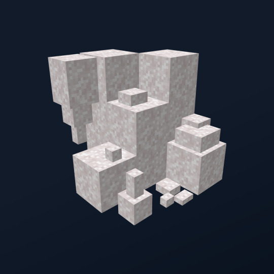
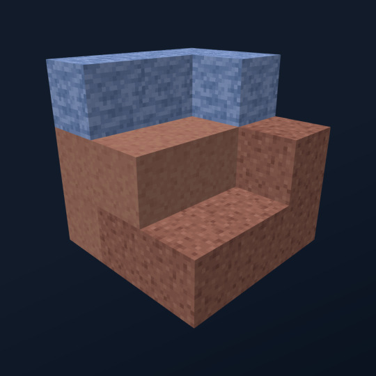
#claystone
Text


#teardropearrings#whiteandgold#dangleteardrop#jewelry#cuff#bracelet#bangle#jilzarah#cuffbracelet#gypsy#claystone#handmade#FashionJewellery#StatementJewellery#handmadebracelet#silvercuff#fashionjewelry#https://poshmark.com/closet/_hellogorgeous1
0 notes
Text
Husband watches his wedding ring wife with first BBC
Hot blonde teen Girl masturbation show on webcam
Big White Cock BWC fuck pov
Negona safada
Bbw wife creamy vibrator
perra latina amateur lo chupa en la cocina
A Superchub Newbie visits me in Toronto, Canada
Un rapidin con mi prima
Celeb blonde girl oltdoor sex with stranger
compilation of threesomes, totally amateur, wife recording husband and husband wife
#unbase#barytocelestine#ribosomal#claystone#conoscopic#credens#sarsars#Atreus#alveolation#detailism#abterminal#tokoloshe#perirectal#scabble#well-aged#Sainte-Beuve#Circum-arean#vesiculobronchial#errite#anathemata
0 notes
Text
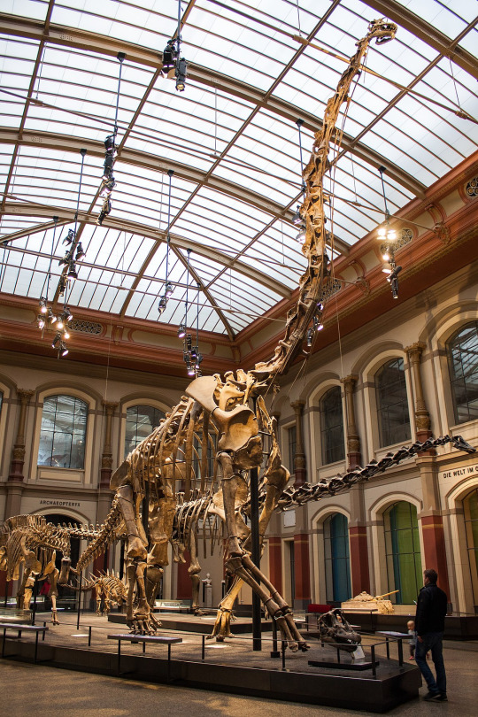
SISTER FORMATIONS: MORRISON, LOURINHA AND TENDAGURU
Back in the Late Jurassic Period, North America, Europe and Africa were next door neighbors.

This is reflected in the similarity of the lithology, and fauna of the rocks. In North America, we have the Morrison Formation, in Europe we have the Lourinha Formation, and in Africa we have the Tendaguru Formation. All of these are contemporaneous or sister formations.
Stratigraphy
The Tendaguru Formation is approximately 177 m thick and broken up into five members: Lower Dinosaur Member (cross-bedded, fine-grained sand and siltstone w/interbedded clay), Nerinella Member (trough cross-bedded and massive sandstone indicating a tidal channels, sandbars and beaches),

Middle Dinosaur Member ( ripple, cross-bedded, fine-grained calcareous sandstone and siltstone and massive to crudely bedded siltstone and claystone indicating tidal flats and lagoons),
Indotrigonia Africana Member (calcite cemented sandstone, conglomerate, thin claystone, and siltstone with sandy limestone indicating tidal and deltaic channels),
and the Upper Dinosaur Member (ripple, cross-bedded, fine-grained sandstone and siltstone with interbedded claystone and micriitic carbonates indicating tidal flats).
The Lourinha Formation is about 200 to 1000 meters thick and is broken into about 5 members: Praia da Amoreira Member (massive mudstone with meter thick sandstone lenses and calcrete layers indicating a meandering river system),
the Porto Novo Member (cross-bedded sandstone indicating a deltaic system), the Praia Azul Member (marl and mudstone indicating brief marine transgression),
and the Santa Rita and Assenta Members (mudstone, caliche, shelly carbonates near the top indicating a landward side of a deltaic system) which are equivalent members from different basins.
The Morrison, as stated previously, is about 200 m thick and consists of 11 different members. I will not go into detail about them again but it should be noted that the formations are approximately the same thickness and made of primarily sand, silt and mudstone.
DINOSAURS
Now for the other fun part: the dinosaur fauna. There are some dinosaurs that are shared between two or all of the formations. These include Ceratosaurus nasicornis in the Morrison and a possible Ceratosaurus in the Tendaguru
and in the Lourinha, Torvosaurus tanneri in the Morrison, Torvosaurus gurneyi in the Lourinha, and a possible Torvosaurus species in the Tendaguru,
Allosaurus fragilis in the Morrison and Allosaurus europaeus in the Lourinha,

Dryosaurus altus in the Morrison and a possible Dryosaurus species in the Lourinha,

Miragaia longicollum in the Lourinha and possibly Miragaia longispinus in the Morrison. Though if that's true, the genus would be Alcovosaurus because that was named first.

And then there are the dinosaurs that were similar to each other in each formation. Filling in the niche or living alongside Dryosaurus was Dystalotosaurus of the Tendaguru,
Eudryosaurus in the Lourinha, and Nanosaurus in the Morrison.
There's Draconyx in the Lourinha and Camptosaurus in the Morrison as early iguanodonts.

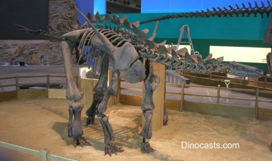
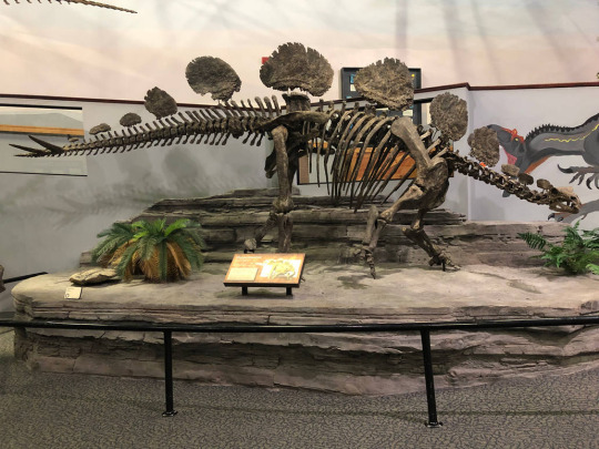
Kentrosaurus in the Tendaguru, Dacentrurus in the Lourinha and Stegosaurus and Hesperosaurus in the Morrison are the main stegosaurs.
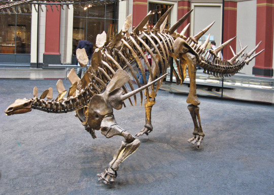

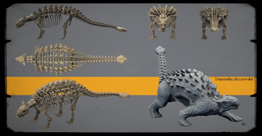
For ankylosaurs, there is Dracopelta in the Lourinha and Mymooropelta and Gargoyleosaurus in the Morrison.

Then there's Dicraeosaurus of the Tendaguru and Suuwassea of the Morrison.

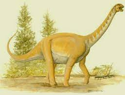
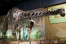
Giraffatitan of the Tendaguru, Lusotitan of the Lourinha and Brachiosaurus of the Morrison all represent brachiosaurs.
Janenschia of the Tendaguru and Haplocanthosaurus of the Morrison represent early sauropods.
Tendaguria of the Tendaguru and Zby of the Lourinha are even earlier sauropods.
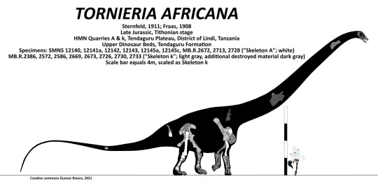
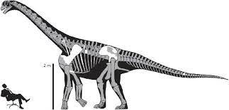
Torneiria of the Tendaguru and Deinheirosaurus of the Lourinha are the diplodocids that match up with the bagillion in the Morrison.
Lourinhasaurus is the camarasaurid representative of the Lourinha.
The Tendaguru and the Lourinha have early carcharadontosaurs in the forms of Veteruristisaurus and Lusovenator.
Lourinanosaurus is the European equivalent of Marshosaurus in the U.S.

And Elaphrosaurus of the Tendaguru is the small to medium-sized equivalent of Tanycoalgreus in the Morrison.

This was a ton of info so if you want it more broken down, message me! I am happy to walk you through it all! Enjoy your weekend!
#paleontology#dinosaur#fossils#geology#lithology#north america#europe#africa#morrison formation#lourinha formation#tendaguru formation#science#allosaurus#torvosaurus#ceratosaurus#stegosaurus#brachiosaurus#giraffatitan#miragaia#kentrosaurus#dacentrurus#mymooropelta#dracopelta#gargoyleosaurus#dryosaurus#sandstone#mudstone#limestone#siltstone#stratigraphy
23 notes
·
View notes
Text
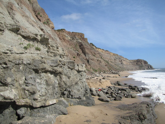
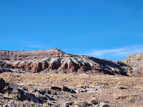
All natural fudge swirls
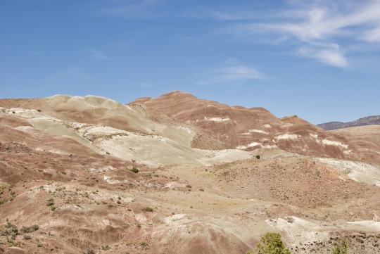

In this remote canyon of Eastern Oregon, claystone has eroded into barren badlands and mounds. The mineral content of the clays, which are the fossil remains of 30 million year-old rainforest soil, is rich in iron oxide and clay minerals that form in warm, wet conditions. The white stripes, which resemble marshmallow cream in a chocolate sundae, are ash deposits from volcanic eruptions that covered the landscape in thick layers of volcanic debris.
The dry, hot conditions of this area of Oregon are already unfavorable to any plants other than grass, sagebrush, and juniper. If you take away soil, add steep slopes and impermeable clay, then you get barren badlands slowly eroding into whimsical mounds. The layers are folded and faulted, which adds to the complexity of the white stripes. What once was nicely ordered is now a mind-boggling puzzle of different layers.
#oregon#geology#pacific northwest#bettergeology#rocks#clay#ice cream#eastern oregon#john day fossil beds#soil#jeep#adventures#oregon desert
19 notes
·
View notes
Text
Along with to Javi, Claystone and Vienna used to be a rescue team together called Bulwark! They unfortunately had to put a long pause on their work due to Claystone having obligations with his birth home

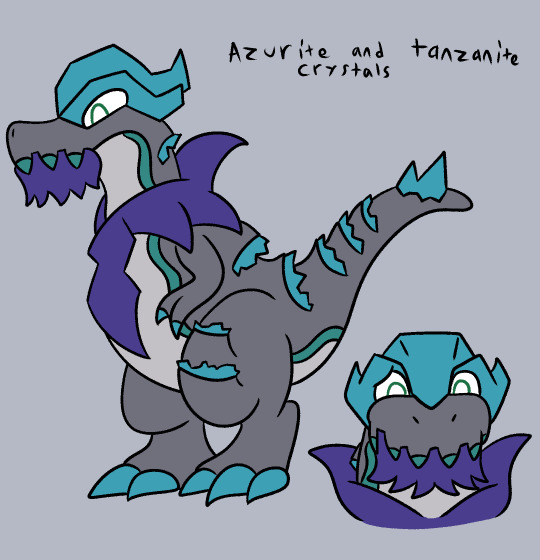
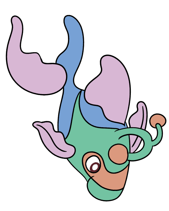

#sherbert draws#art#artists on tumblr#digital illustration#pokemon pmd#pokemon#pokemon oc#tyrantrum#lanturn
8 notes
·
View notes
Text
Time for some preliminary geology!*
*as according to the world of Planet 55e in the Solus System.
Carbonatite: Igneous rock. Contains Coal, Iron, Copper, occasional trace elements Radium and Lead. Frequently patches of Mudstone and Claystone.
Limestone: Sedimentary rock. Contains Quartz, Fossils, occasional trace element Celestine. Frequently forms stalactites and stalagmites. Frequent patches of Mudstone and Claystone.
Shale: Sedimentary rock. Contains Quartz, Coal, Fossils. Soft, crumbly rock.
Sandstone: Sedimentary rock. Very rarely contains fossils. Frequent layers of Claystone and Mudstone.
Claystone: Sedimentary rock.
Mudstone: Sedimentary rock.

Marble: Metamorphic rock. Contains Quartz, Iron. Frequently forms stalactites and stalagmites.
Mantlerock: Igneous rock. Incredibly dense and radiates warmth. Composition contains trace amounts of Obsidian, Pyroxene, and Radium. Makes up 98.133% of Planet 55e's Mantle.
Gravel: Aggregate.
Dirt/Mud/Mudstone: Sediment/Sediment/Sedimentary Rock
Clay/Hardened Clay/Claystone: Sediment/Hardened Sediment/Sedimentary rock.

The Foundry Corporation thanks you in advance for your assistance in providing further analysis of Planet 55e's Crust and Mantle layers. Any new discoveries will be met with a bonus stipend from your Foreman upon confirmation of new discovery. See the 'Welcome Manual' page #831, subsection A, for further information.
#regrowal#regrowalthegame#oc lore#worldbuilding#but like literally#its the stuff that we put the cool stuff on and in#pixelart#3d artwork#aseprite#game dev blog#pixel art#pixel graphics#blockbench#game dev stuff#indie dev#indiegamedev#dev blog#dev log#indie game dev#game development#gamesblog#survival games#geology#rocks#minerals#gems#stones#earth
5 notes
·
View notes
Note
I will now recite the rocks in alphabetical order:
adamellite
amphibolite
andesite
anorthosite
anthracite
appinite
aphanite
arenite
argillite
arkose
basalt
basanite
blueschist
biomicrite
biosparite
boundstone
breccia
carbonatite
cataclasite
chalk
chert
claystone
clinopyroxenite
coal
conglomerate
coquina
dacite
diamictite
diatomite
diorite
dolomite
dunite
eclogite
essexite
evaporite
flint
foidite
gabbro
gabbronorite
gneiss
gossan
granite
granodiorite
granophyre
granulite
graywacke
gritstone
greensand
greenschist
harzburgite
hornblendite
hornfel
hyaloclastite
icelandite
ignimbrite
ijolite
itacolumite
jadeitite
jasperoid
jaspillite
kenyte
kimberlite
komatiite
lamproite
lamprophyre
larvikite
laterite
latite
lherzolite
lignite
limestone
litchfieldite
litharenite
llanite
luxullianite
mangerite
marble
marl
metapelite
metapsammite
migmatite
minette
monzodiorite
monzogranite
monzonite
mudstone
mylonite
nepheline syenite
nephelinite
norite
novaculite
obsidian
oil shale
oolite
pantellerite
pegmatite
peridotite
phonolite
picrite
porphyry
phyllite
pseudotachylite
pumice
pyrolite
pyroxenite
quartzarenite
quartzite
rhyolite
sandstone
schist
scoria
shale
siltstone
serpentinite
shonkinite
skarn
slate
suevite
soapstone
syenite
syenogranite
taconite
tephrite
teschenite
theralite
tholeiite
tonalite
trachyte
travertine
tuff
turbidite
urtite
variolite
wackestone
websterite
wehrlite
whiteschist
xenolith
3 notes
·
View notes
Text
Heads Up 7 Up!
@dyrewrites got me again!
Here's some more from that recent chapter of Monsters and Fools, a dark political noire in a post-apoc setting.
***
Sobs trickled out of her, and her shoulders shook. She leaned against the wall, into the cool claystone.
I reached for her and set a hand on her shoulder for a bit of comfort, and placed her fingers atop mine. Una turned her head against the wall to hide her face, covering with her free hand. We just stood in the cramped corner as she sobbed into the silence, the echo caught in our bodies.
I glanced between Nathu and Una, not knowing what to say. He didn’t make any more arguments; just waited, the space between them charged.
***
Tagging in:
@purplehandshumanfeelings
@moonluringfrost @on-noon @charlesjosephwrites @gummybugg @stories-by-rie @fire-but-ashes-too @rmgrey-author @jasperygrace
#polyamory#post apoc#indie#writers of tumblr#writelbr#wip#Monsters and Fools#scifimagpie#the nightmare cycle#the underlighters
6 notes
·
View notes
Text
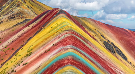
In which mountain system can you find Vinicunca or Rainbow Mountain?
Vinicunca, Montaña Arcoíris (Rainbow Mountain), is a mountain in the Peruvian Andes. It is 5,200 metres (17,100 ft) above sea level and is located to the southeast of the city of Cusco.
According to the Cultural Landscape Office of the Decentralization of the City of Cusco, the mountain is made up of several colours due to its mineralogical composition. The pink colour is caused by red clay, whilst the whitish colouring is due to quartzose, sandstone and calcium carbonate. The red is due to claystones; the green is due to phyllites; the earthy brown is a product of fanglomerate; and the mustard yellow colour comes from the calcareous sandstones.
5 notes
·
View notes
Photo
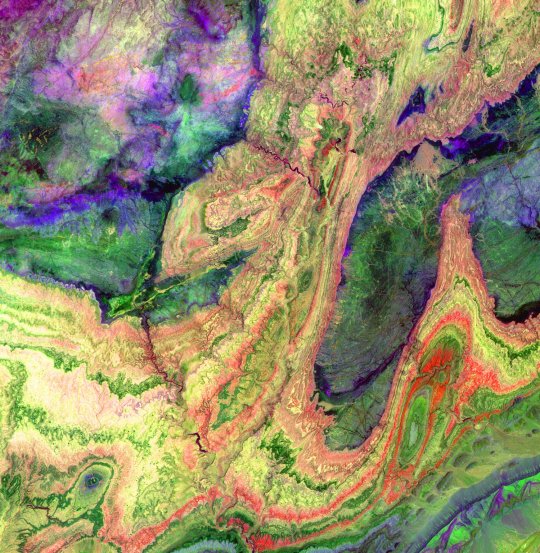
The Anti-Atlas Mountains of Morocco formed as a result of the collision of the African and Eurasian tectonic plates about 80 million years ago. This collision destroyed the Tethys Ocean; the limestone, sandstone, claystone, and gypsum layers that formed the ocean bed were folded and crumpled to create the Atlas and Anti-Atlas Mountains. In this ASTER image, short wavelength infrared bands are combined to dramatically highlight the different rock types, and illustrate the complex folding. The yellowish, orange and green areas are limestones, sandstones and gypsum; the dark blue and green areas are underlying granitic rocks. The ability to map geology using ASTER data is enhanced by the multiple short wavelength infrared bands, that are sensitive to differences in rock mineralogy. This image was acquired on June 13, 2001 by the Advanced Spaceborne Thermal Emission and Reflection Radiometer (ASTER) on NASA's Terra satellite. With its 14 spectral bands from the visible to the thermal infrared wavelength region, and its high spatial resolution of 15 to 90 meters (about 50 to 300 feet), ASTER images Earth to map and monitor the changing surface of our planet. ASTER is one of five Earth-observing instruments launched December 18, 1999, on NASA's Terra satellite. The instrument was built by Japan's Ministry of Economy, Trade and Industry. A joint U.S./Japan science team is responsible for validation and calibration of the instrument and the data products. The broad spectral coverage and high spectral resolution of ASTER will provide scientists in numerous disciplines with critical information for surface mapping, and monitoring of dynamic conditions and temporal change. Example applications are: monitoring glacial advances and retreats; monitoring potentially active volcanoes; identifying crop stress; determining cloud morphology and physical properties; wetlands evaluation; thermal pollution monitoring; coral reef degradation; surface temperature mapping of soils and geology; and measuring surface heat balance. Dr. Anne Kahle at NASA's Jet Propulsion Laboratory, Pasadena, California, is the U.S. Science team leader; Bjorn Eng of JPL is the project manager. The Terra mission is part of NASA's Earth Science Enterprise, a long- term research effort to understand and protect our home planet. Through the study of Earth, NASA will help to provide sound science to policy and economic decision-makers so as to better life here, while developing the technologies needed to explore the universe and search for life beyond our home planet. Size: 28.7 x 29.4 km (17.8 x 18.2 miles) Location: 29.4 deg. North lat., 8.9 deg. West long. Orientation: North at top Image Data: ASTER bands 4,6 and 8. Original Data Resolution: 30 m Date Acquired: June 13, 2001
3 notes
·
View notes
Note
hello rock licker
Has my daughter ever explained the rock licker thing? Or does she just think it is funny to call me a rock licker?
Edit to add:
I ask because there are two times that licking a rock can help identify the rock.
Halite is sodium chloride and is a relatively clear mineral with a crystalline cubic lattice that tastes salty. Silvite is a relatively clear mineral with a crystalline lattice that tastes bitter.
The other time it is useful is with siltstone and claystone. Both are sedimentary rocks that have particles that are too small to see with the naked eye. Siltstone will feel gritty against your teeth while claystone is smooth against your teeth.
2 notes
·
View notes
Text
Saltwater sits on my tongue,
Reminiscent of the fresh breath of the ocean
or of a deserted waste of dried minerals
leaching into cracked claystone
The sickly sweet smell of spring flowers
enters my nose in an attack of the senses
Either that or the stench of roofing glue wafting over buildings
I see the soft glow of the sun disappearing behind the earth
and sigh into the evening air, wondering where my day has gone
Besides, it could just be city lights along the horizon
I dig my fingers into the earth, desperate for something real
It is rich and full of feeling, it is messy and good
But where are the worms? I dig and dig but I cannot find them
I dig further into the earth, past the wares of others' lives
tossing aside stones until the dirt turns into oil in my hands
I stare up from the bottom of the hole, listening for the sound of hope
There is only the groaning of machines
0 notes
Text
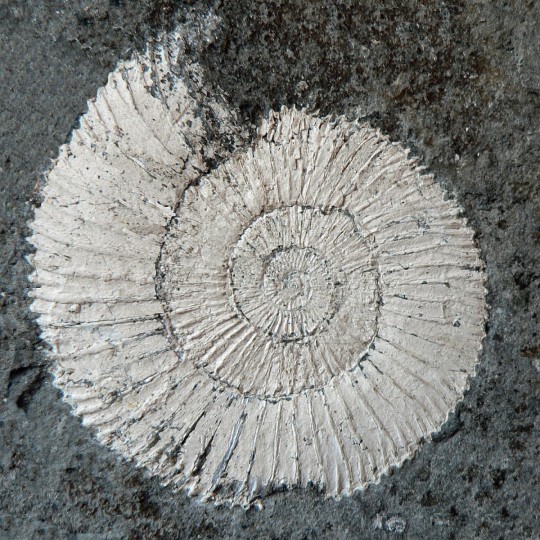
Shining white ammonites: remarkably preserved ammonites from the Posidonia Shales of Southern Germany
Stephen Lautenschlager (Germany)
The Lower Jurassic Posidonia Shale Formation of Southern Germany belongs to one of the most famous fossil lagerstätten in the world. Its sediments – finely laminated marly claystones – were deposited in a shallow, inland (epicontinental) sea, the Tethys Ocean, under tropical conditions. The dark grey colour of these bituminous shales is a result of the high…
View On WordPress
0 notes
Text

youtube
While it's easy to mistake this outcrop for the Painted Hills, this is actually older rock of a very similar origin. To summarize, this red claystone is a geologic library of ancient climate. The various minerals and microfossils found in this red clay tell a story of a time when Oregon was a volcano dominated subtropical rainforest. This is rock older than the Cascade Mountains! What exactly can we learn from it? Find out on BetterGeology!
#geology#oregon#pacific northwest#rocks#oregon geology#bettergeology#science video#geology video#videos#clay#central oregon#john day fossil beds#Youtube
10 notes
·
View notes
Text
Yndaros : Old Kadizar
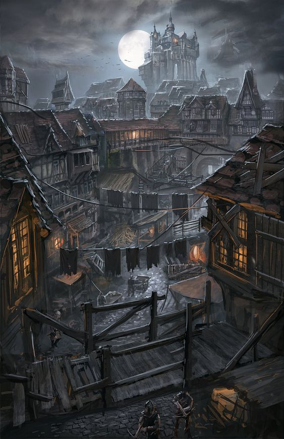
The barbarian village of Kadizar was established about a century ago, by the clan Kadiz which had made an enemy of the Jezites – the region’s most powerful force back then. Searching for a safehaven, they dared to challenge the taboos and entered the abandoned city-state, where they soon settled down and built a claystone wall for further protection. The location they selected lay close to the waters of River Doudram and included an ancient tower-ruin to function as a lookout for keeping an eye on the enemy up north.
The twenty-foot-high bailey is still standing, and within it is still a mixture of Kadizian claystone houses, Lindarian buildings and a few ruins from the time of Symbaroum. Before the arrival of the Ambrians the old tower ruin was the residence of the chieftain, but since then its sections have been divided between different occupants – the local headquarters of the city watch composes one section, while the informal leader of Old Kadizar, the thief king Nobleman Dastan, resides in the remodeled tower itself. Beneath the complex a widely debated excavation is taking place, organized by Ordo Magica. If they have found anything noteworthy, the excavation leader, Master Marbela, has managed to keep it a secret.
Today the overcrowded Old Kadizar has about four thousand inhabitants, a majority of which only survive thanks to alms, day laboring and begging in the streets. The jobs available are often burdensome, dangerous and smelly: the city’s tannery lies within the wall, as well as the headquarters of the sewer workers and the guild of the blacksmiths. Of course, the leaders among the tanners, the “sewer rats” and the blacksmiths have a lot of power and influence in Old Kadizar, just like the proprietor of the claystone plant, Lord Manselm.
Many of the inhabitants choose to lead a criminal life, too proud or too greedy to settle for the meager outcome of honest labor. Because of that, an informal power structure has emerged, with Nobleman Dastan on top. It is said that he has made a fortune from organized begging, pickpocketing, renting out manpower and so on. And he is of course as determined to oppose any rebellious tendencies as the city watch has ever been.
1 note
·
View note
Text
Weingut Eckehart Gröhl Riesling Niersteiner "Roter Hang" Rheinhessen 2022
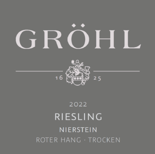
Ortswein / 100% Riesling / organic (in conversion) / 12% alc. / 2.4 g/L RS / 8.0 g/L acidity
A Riesling from Rheinhessen's famous Roter Hang that reflects the special character of the special soil. Rotliegend, a red-colored rock created in the Rotliegend period of the Earth’s history, is formed from calcareous claystone, siltstones, and sandstones, red (rot) from finely distributed iron in the soil. It’s slowly being compressed or “slated” over time. Spontaneous fermentation in stainless steel tanks. Saltiness is the first word written in my notebook, followed by yellow peach, and lemony citrus. Riesling from the Rotliedend soil often has a spicy, herbal note which comes through in this wine. Classic Roter Hang character. ***++
Imported by: Veritable Wines & Estates Miami, FL
download / gröhl / riesling / rheinhessen / 2022
0 notes
Last Seen Blogs

myinterests
Hotwife Experiences

vediamma
friend mom

blacksheep-confessions
Confessions of a Black Sheep

morriscribbles
Morris' Art Blog

frostsims4
FROST SIMS