#drone sensor
Explore tagged Tumblr posts
Visit Tumblr Blog
Explore Tumblr blogs with no restrictions, modern design and the best experience.
Last Seen Tumblr Blogs


Fun Fact
Women make up for the other 50% of Tumblr’s audience.
Text
Want To Know more about Global Drone Sensor Market?
The Global Drone Sensor Market is expected to grow from USD 1.21 Billion in 2023 to USD 6.27 Billion by 2031, driven by advancements in sensor technology and increasing drone adoption across industries. This report provides an in-depth analysis of key sensor types including camera, LiDAR, GPS, and ultrasonic sensors, highlighting their applications in sectors such as agriculture, construction, defense, and surveillance. Key market players like Bosch Sensortec, Trimble, and Raytheon are leading the market. Explore growth drivers, trends, opportunities, and competitive strategies shaping the future of the drone sensor market.
Get access to full report here.
0 notes
Text

I return with some fun, low-effort Murder Drones doodles because that's the only thing I have the time and energy for right now (turns out moving to another state to escape day job hell and also the transphobia is A Very Involved Process).
Speaking of moving and other life changes, I have a Patreon and Ko-fi now, for those of you who like what I do and want me to be able to do more of it faster.
My apologies to anyone who's actually fluent in Russian, because I am very much not and I sincerely hope google translate didn't screw me over.
Close-ups under the cut (click for best viewing):
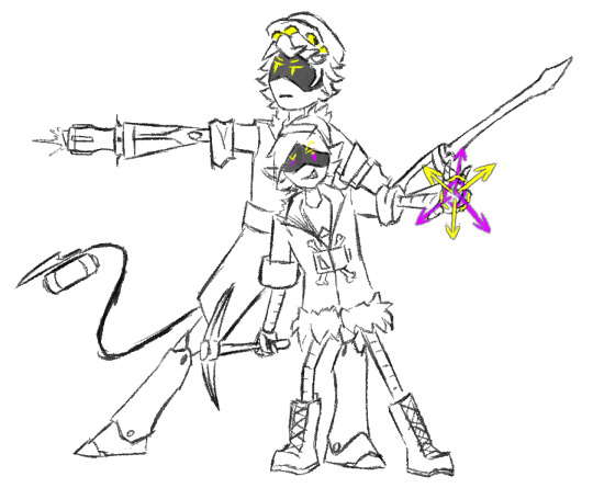


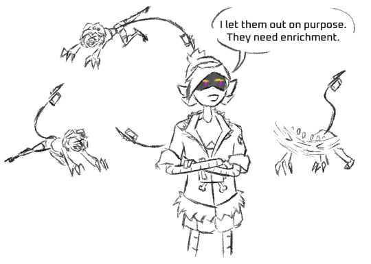


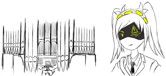
#some of these are actually plot-relevant to my MD fan project sequel fic thing#why is Doll having a character arc? who is the green-eyed punk drone with a sensor array?#why does J have The Manor Sword and why is she beating the tar out of her emotions with Dramatic Pipe Organ Music and Signalis references?#well the answer to the first two is “because she deserves one”...#...and “Astel Hayden: walking excuse to do weird stuff with the Solver and also put more Internecion Cube in my Murder Drones”#as for the third... I think we can all guess#(it's Tessa. the answer is always Tessa)#uzi doorman#uzi murder drones#serial designation n#serial designation v#serial designation j#n murder drones#v murder drones#j murder drones#lizzy murder drones#doll murder drones#nuzi#biscuit bites#nuziv#violentbitingbiscuits#dizzy murder drones#murder drones oc#astel hayden#murder drones#murder drones fanart#artists on tumblr
165 notes
·
View notes
Text
Unlock Precision with LiDAR Sensor, 3D Mapping, and Drone Survey Solutions by LiDAR Solutions
LiDAR Solutions leads the industry with advanced LiDAR sensor, 3D mapping, and drone survey services tailored for diverse projects. Using state-of-the-art technology, we provide accurate, detailed data that helps businesses make informed decisions efficiently.

Our cutting-edge LiDAR sensor technology captures precise spatial information by emitting laser pulses and measuring the reflected signals. This method allows us to create high-resolution maps of terrain and structures, offering unparalleled detail and accuracy. Whether you’re working on environmental assessments or infrastructure development, our LiDAR sensor applications deliver valuable insights.
Combining this technology with 3D mapping, we generate comprehensive digital models that represent real-world environments in stunning detail. Our 3D mapping services support urban planning, construction, mining, and more by visualising complex surfaces and volumes with ease. This data helps you plan effectively and identify potential challenges before they arise.
Our drone survey services complement our LiDAR and mapping offerings by capturing aerial perspectives quickly and safely. Using UAVs equipped with advanced sensors, we perform thorough site inspections and data collection even in hard-to-access areas. Our drone survey solutions save time, reduce costs, and improve safety compared to traditional methods.
At LiDAR Solutions, we customise every project to fit your needs, ensuring seamless integration of LiDAR sensor, 3D mapping, and drone survey data into your workflow. Our experienced team guides you from consultation to delivery, providing expert support throughout.
If you want accurate, reliable spatial data for your project, trust LiDAR Solutions for your LiDAR sensor, 3D mapping, and drone survey needs. Reach out today and discover how our technology-driven services can elevate your next project with precision and efficiency.
Source
0 notes
Text
Sony revoluciona la visión de drones con un sensor compacto que imita la aguda vista del águila
Sony ha presentado el AS-DT1, un sensor de profundidad LiDAR compacto que promete mejorar las operaciones de los drones. Con unas medidas de aproximadamente 1,14 pulgadas y un peso de 1,76 onzas, este sensor incorpora tecnología avanzada en un formato reducido, ofreciendo notables capacidades a pesar de su ligereza. En el corazón del AS-DT1 encontramos la innovadora tecnología Direct Time of…
0 notes
Text
The global drone sensor market size reached USD 981 Million in 2024. Looking forward, IMARC Group expects the market to reach USD 5,017 Million by 2033, exhibiting a growth rate (CAGR) of 19.9% during 2025-2033.
0 notes
Text

Adam's drone being too cute in this illustration 😩🧡
#* visage.#// the twinkle in his sensor AH#// When are you going to give me threads where he's piloting his drone#// talking more through it and doing cool and cute spins in the air#// A NEED
1 note
·
View note
Text
youtube
#Here’s a **YouTube video description** tailored to your agricultural video:#---#**Description:**#Welcome to our video on **empowering Indian farmers**! 🌾#In this video#we explore the **future of farming in India**#focusing on **sustainable practices**#**water conservation techniques**#and the **latest agricultural technologies** that can help you boost productivity and protect the environment. We’ll also highlight **gover#making it easier to adopt new tools and methods for growing better crops.#🚜 **What You’ll Learn:**#- How to implement **sustainable farming practices** like crop rotation#organic farming#and natural pest management.#- The importance of **water conservation** and how technologies like **drip irrigation** and **rainwater harvesting** can make a huge diffe#- How **technology** can transform your farm with tools like **mobile apps**#**drones**#and smart sensors to monitor crop health and improve yields.#- **Government schemes and subsidies** that can help you invest in new technologies and improve your farm’s output.#Whether you’re a seasoned farmer or new to agriculture#this video will provide valuable insights and tips to help you grow your farm sustainably and increase your income. Together#we can create a **brighter future for Indian agriculture**!#🌱 **Stay tuned and subscribe** for more tips on modern farming and how to make your farm more efficient and profitable.#**#SustainableFarming#IndianFarmers#WaterConservation#AgriTech#FarmingTips#IndianAgriculture
1 note
·
View note
Text
youtube
New video! Taking a look at the 12.5mp and 50mp modes on the DJI Air 3S to see which is best.
*HINT* It's not what you might think...
#dji air 3s#drone#air 3s#dji#drone video#technology#drones#quadcopter#dronestagram#tech#quadbayer sensor#youtube video#Youtube
1 note
·
View note
Text
Drone Photography Evolution: BSI 2 Sensor Technology Explained

Ever wondered how drones capture those breathtaking aerial shots with perfect clarity and minimal distortion? The secret lies in cutting-edge camera technologies like the Global Shutter GigE Camera. Whether you’re a drone enthusiast, a professional photographer, or someone frustrated by blurry or distorted aerial images, understanding the evolution of drone photography can offer a solution to your woes. Let’s dive into how innovations such as BSI 2 sensors and global shutter technology are revolutionizing the world of aerial imaging.
The Customer Pain Point: Overcoming Motion Distortion
For drone photographers, motion blur and rolling shutter distortions are significant challenges. These issues arise when traditional cameras, equipped with rolling shutters, fail to handle fast-moving subjects or high-speed drone operations. In these scenarios, straight lines appear skewed, and the resulting images lose their professional quality.
Global Shutter GigE Cameras address this pain point. Unlike rolling shutters, global shutters capture the entire frame at once, eliminating distortions caused by rapid motion. Paired with BSI (Backside-Illuminated) 2 sensors, this technology ensures crisp, detailed imagery, even in challenging environments or low-light conditions.
Understanding BSI 2 Sensor Technology
What is BSI Technology? BSI sensors differ from conventional sensors by reversing the structure, placing the photodiodes closer to the light source. This design minimizes light loss and improves sensitivity, making them ideal for low-light photography.
The second generation of BSI sensors, or BSI 2, builds upon this concept, offering enhanced dynamic range, reduced noise, and faster readout speeds. When integrated with a Global Shutter GigE Camera, these sensors transform drones into powerful imaging tools capable of capturing high-resolution photos and videos.
Why Global Shutter Matters in Drone Photography
Eliminating Distortion Traditional rolling shutters read the frame line by line, often leading to "jello" effects or skewed images when capturing fast-moving scenes. Global shutters, however, read the entire frame simultaneously, preserving straight lines and avoiding unwanted distortions.
High-Speed Performance Drones often operate at high speeds, making it difficult for traditional cameras to keep up. Global Shutter GigE Cameras excel in such scenarios, providing accurate frame captures without lag or inconsistencies.
Improved Synchronization GigE (Gigabit Ethernet) connectivity allows these cameras to synchronize seamlessly with other systems, enabling real-time data transfer and advanced imaging functionalities crucial for professional drone applications like mapping, surveillance, and inspections.
Applications of Global Shutter GigE Cameras in Drone Photography
Aerial Mapping and Surveying Accurate and distortion-free images are vital for creating detailed maps or conducting land surveys. Global shutter technology ensures precision, while BSI 2 sensors capture intricate details in varying light conditions.
Search and Rescue Missions During emergencies, drones equipped with Global Shutter GigE Cameras can quickly scan large areas without compromising image quality. The ability to capture clear images in low light or at high speeds makes these cameras indispensable for such missions.
Cinematic Aerial Shots For filmmakers, the combination of global shutter technology and BSI 2 sensors delivers stunning visuals. Whether it's a fast-paced action sequence or a serene landscape, these cameras ensure the highest quality output.
Agricultural Monitoring Farmers and researchers rely on drones to monitor crops, assess soil health, and track livestock. The precision of Global Shutter GigE Cameras provides actionable insights, enhancing productivity and sustainability.
Benefits of Global Shutter GigE Cameras
Crystal-Clear Images Whether you're capturing cityscapes or dense forests, the technology ensures that every detail is sharp and distortion-free.
Low-Light Superiority Thanks to BSI 2 sensors, these cameras excel in low-light conditions, making them ideal for dawn or dusk photography.
Durability and Reliability Designed for industrial use, Global Shutter GigE Cameras are robust and can withstand the challenges of outdoor drone operations.
Seamless Integration With Gigabit Ethernet, these cameras are easy to integrate into existing drone systems, offering real-time performance and high-speed data transfer.
Elevating Drone Photography: Why You Should Invest
If you’ve been struggling with poor-quality drone images or videos, it’s time to consider upgrading your equipment. Global Shutter GigE Cameras with BSI 2 sensors are game-changers, offering a practical solution to common photography pain points. Their ability to deliver distortion-free, high-quality images makes them a must-have for professional and hobbyist drone operators alike.
Explore Advanced Drone Camera Solutions
Ready to take your drone photography to the next level? Equip your drone with a Global Shutter GigE Camera today and experience the difference in image quality and performance.
Check out our range of high-performance cameras here. Whether you’re shooting cinematic masterpieces or conducting critical surveys, our cameras are designed to exceed your expectations.
0 notes
Text
House Oversight Committee Holds A Hearing On Unidentified Aerial Phenomenon (UAP)
youtube
UAP...
#Russia studies UFO reports to develop insight into the weaknesses and blind spots of US sensors#Russia then develops countermeasures and exploits to defeat US sensors#there are no UFOs in Russia or China funnily enough. Just U2 spy planes drones SR71 etc#the successful exploitation of the paranoia and UFO mythos goes back to the early Cold War#the US House Oversight Committee is literally being used as a tool of Russian Intelligence here on a fishng expedition#Youtube
0 notes
Text
The DJI Mavic 3 Enterprise is a professional-grade drone ideal for industries like maritime operations, surveying, and public safety. It features high-resolution imaging, thermal sensors, and real-time data transmission for enhanced situational awareness. With extended flight time and obstacle avoidance, it navigates complex environments safely. The Mavic 3 Enterprise efficiently supports tasks like infrastructure inspection, environmental monitoring, and security surveillance, making it essential for optimizing operations across various applications.
#dji mavic 3#mavic 3 enterprise#drone technology#surveying drones#thermal sensor#maritime safety#dynatechinnovations#drones#uae
1 note
·
View note
Text
Oppo Find X7 Ultra 5G Smartphone Debuts World-First Quad Main Camera with Hyper Tone Image Engine | OPPO Global
Oppo Find X7 Ultra 5G Smartphone की बढ़ती डिमांड को लेकर भारत में किया बड़ा धमाका! लॉन्च हुआ जबरदस्त टेक्नोलॉजी और 5G नेटवर्क के कनेक्टिविटी के साथ! इसमें लगा दिया सबसे बड़ी डिस्प्ले, शानदार कैमरा सेटअप, और लंबी बैटरी लाइफ जो बनता हैं इस फोन को और भी खास, यह स्मार्टफोन यूज़र फ्रेंडली इंटरफ़ेस और लेटेस्ट सॉफ्टवेयर के साथ डिज़ाइन किया गया हैं, जो इसे एक ऑलराउंडर बजट स्मार्टफोन बनाता है। अगर आप…
#1-inch sensor#AI smartphone#Find X7 Ultra#Hasselblad camera tuning#HyperTone Camera System#Mobile#natural color reproduction#Oppo#OPPO Find X7 Ultra#Oppo Find X7 Ultra 5G Smartphone#periscope telephoto#pro-grade photography mode#smartphone photography#Today Wold#vivo t3 pro 5g drone camera
0 notes
Text
“The Houthis shot down the 12th Reaper drone (MQ-9 Reaper)”
“The second important point is that the US has a huge problem with reconnaissance assets on the modern battlefield. The story of getting rid of the Reapers is part of a more interesting process of the US abandoning large unmanned systems. The US has already gotten rid of the Predators (MQ-1 Predator), and in the next two years they will completely get rid of the Global Hawk (MQ-4 Global Hawk), and now there are only 9 of them left. Although they are all relatively new, the oldest was released in 2011. The price is from 140 to 260 million dollars per unit (the F-35 nervously smokes on the sidelines).”
:
2 notes
·
View notes
Text
Boost Your Project’s Accuracy with Drone Survey, 3D Mapping & LiDAR Sensor Technology
At LiDAR Solutions, we understand how vital precise data is for your project’s success. That’s why we specialise in expert drone survey, 3d mapping, and advanced LiDAR sensor technology. By combining these cutting-edge services, we help you capture detailed information faster and more efficiently than ever before.

Our drone survey service offers a bird’s-eye view that covers large areas quickly. Equipped with state-of-the-art cameras and sensors, our drones collect high-resolution imagery and data even in hard-to-reach places. This approach not only speeds up your project but also keeps your team safe by reducing the need for on-ground inspections.
Using the data from our drone survey, we perform precise 3d mapping to create accurate, detailed models of terrain, structures, and landscapes. Our 3d mapping capabilities support industries like construction, mining, agriculture, and environmental management by providing comprehensive visualisations for planning and analysis.
Our advanced LiDAR sensor technology takes your data collection a step further. By emitting laser pulses and measuring their return time, the LiDAR sensor generates incredibly accurate 3D representations, capturing minute details that traditional methods might miss. Integrating this technology with our drone survey and 3d mapping services ensures you receive a complete, precise dataset tailored to your project’s needs.
At LiDAR Solutions, we tailor every service to suit your unique requirements. Our experienced team supports you throughout the entire process, from initial consultation to final data delivery, ensuring seamless integration with your workflow.
If you’re after reliable, innovative solutions, LiDAR Solutions is your go-to for drone survey, 3d mapping, and LiDAR sensor technology. Contact us today to see how we can help bring precision and clarity to your next project.
Source
0 notes
Text
Instalación de Sensores: Heimdall Power impulsa el uso de drones para la rápida instalación en líneas eléctricas de EE.UU.
Con la creciente demanda de electricidad y la aparición de nuevos marcos regulatorios, las empresas de servicios públicos en EE.UU. están adoptando tecnologías avanzadas para modernizar su infraestructura. Heimdall Power ha presentado una estrategia innovadora que incorpora drones para la instalación de sensores en las líneas eléctricas, con el objetivo de ayudar a las utilities a cumplir…
0 notes