#lidar scanning
Explore tagged Tumblr posts
Visit Tumblr Blog
Explore Tumblr blogs with no restrictions, modern design and the best experience.
Last Seen Tumblr Blogs


Fun Fact
Users from the US are the majority of Tumblr visitors.
Text

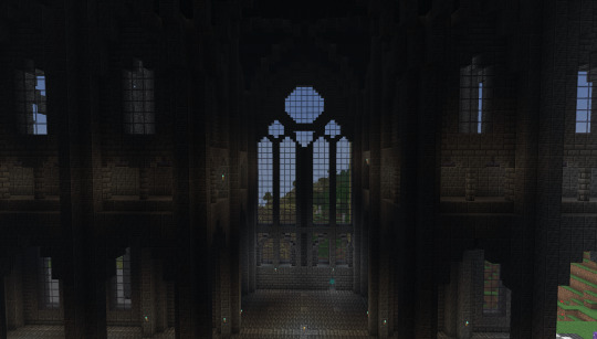
I'm once again too lazy to fish up my previous cathedral build posts so here we go with another new one lol
I just finished one of the transept windows! I'm just kinda building along on vibes before I have to do the apse, ambulatory, and radiating chapels :') this was based roughly on the transept windows of the Metz cathedral, keeping with my theme of French gothic(ish).
Bonus: a sucky screenshot of my happy ghast helping me build :) if you dismount them while mid-air they'll float in place, making them super helpful for high-up building

#i found an interactive lidar scan of the metz cathedral online and it's been SO HELPFUL#there are parts of cathedrals that i've felt like i've needed better ref pics of but couldn't find easily#as i learn more and more i'm realizing i kinda goofed and should've swapped the sizes of the base + clerestory windows but it's okay#i also did not build this on an east-west axis but rather north-south. so. i'm crying a little bit about that but. it's okay#my vacation is helping me be my autistic self but in a good special interest kind of way and not in a burnout/meltdown way for once
1 note
·
View note
Text
Smarter Land Insights with Drone Surveys, LiDAR and 3D Scanning
Land development and infrastructure planning need more than rough estimates—they demand precision. At LiDAR Solutions, we deliver that accuracy through a combination of drone survey, lidar surveys, and 3d scanning technologies.
A drone survey offers a faster, safer, and more cost-effective way to gather data. Our drone teams can access rugged terrain, dense bushland or wide-open sites without putting anyone on the ground. Whether you’re managing a construction site or monitoring a mining operation, aerial data collection gives you the insights you need in less time.
But a drone is only as good as its sensors. That’s where lidar surveys come in. These high-precision surveys use laser pulses to map the surface in extraordinary detail. Our lidar surveys work through tree canopies, uneven ground, and even poor light conditions—delivering clean, detailed 3D elevation models.
To bring your site data to life, we integrate 3d scanning into every stage. This process creates accurate digital models of buildings, landscapes or infrastructure. With 3d scanning, you can visualise structural details, measure distances, and plan confidently—before breaking ground. Engineers, architects, and local councils rely on this technology to reduce risk and improve outcomes.
By combining all three methods, we help our clients reduce errors, save time, and meet tight deadlines without compromising on accuracy. Every job comes with expert guidance and post-survey analysis, so you can act with confidence.
At LiDAR Solutions, we tailor every project to your needs. Whether it’s a large-scale development, heritage mapping, or environmental monitoring, we bring the latest tech and a hands-on approach to every site.
Let’s raise the standard of how you map, model, and manage your land. Reach out to our team to see how we can help you turn data into smarter decisions.
Source
0 notes
Text
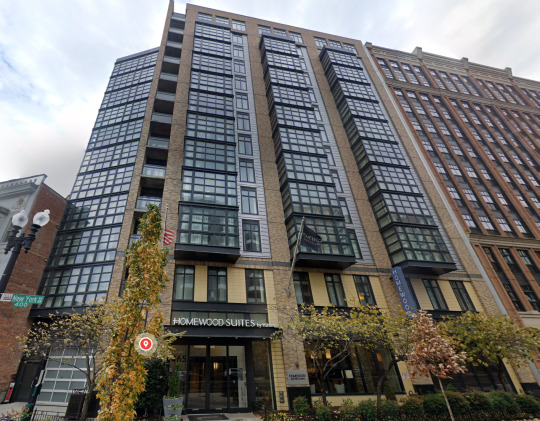
3D Laser Scanning for Homewood Suites Franchise by Hilton Hospitality - NY Project
For the Homewood Suites Franchise by Hilton Hospitality located in New York, our team provided advanced 3D laser scanning services to support precise as-built documentation and facilitate renovation planning.
Using state-of-the-art laser scanning technology, we captured highly accurate point cloud data of the existing building structure, enabling detailed analysis and seamless integration into BIM workflows.
Key Highlights:
Accurate 3D Laser Scanning: We employed cutting-edge 3D laser scanners to capture the building’s interior and exterior geometry with millimeter precision, ensuring all architectural and structural elements were documented flawlessly.
Point Cloud to BIM Modeling: The collected point cloud data was processed and converted into detailed BIM models, allowing Hilton’s project managers and architects to visualize the existing conditions in 3D and plan renovations efficiently.
Time and Cost Efficiency: Our precise scanning reduced the need for manual measurements and rework, accelerating the project timeline and lowering overall costs for Hilton Hospitality.
Enhanced Renovation Planning: The 3D laser scanning data provided a reliable foundation for design coordination, clash detection, and improved communication among stakeholders.
Technology Used:
Leica RTC360 3D laser scanner and Autodesk Revit for BIM modeling.
Benefits to Client:
This comprehensive 3D scanning solution enhanced accuracy, minimized risks during renovation, and ensured the Homewood Suites franchise in New York met Hilton Hospitality’s high standards for quality and guest experience. Also Read - https://www.tejjy.com/project/laser-scanning-for-homewood-suits-by-hilton-ny-project/
#laser scanning#construction#3d laser scanning#3d scanning#building design#urban architecture#rtc360#technology#lidar technology
0 notes
Text
Comparison of Lidar and 3D Laser Scanning in Urban Planning and Infrastructure Development

Urban planning and infrastructure development rely heavily on advanced mapping and surveying technologies. Among them, Lidar technology and 3D laser scanning stand out as two of the most effective methods for collecting accurate spatial data. While both use laser pulse-based remote sensing technology, they differ in their applications, accuracy, and data processing capabilities. Understanding the difference between Lidar and laser scanning is crucial for professionals in construction, civil engineering, GIS mapping, and infrastructure planning.
Key Differences: Lidar vs 3D Laser Scanning
LiDAR and 3D laser scanning are both methods for obtaining accurate spatial information, but they have distinct applications and technologies. LiDAR utilizes pulsed laser beams to create maps of extensive areas, making it suitable for aerial surveys and autonomous vehicles. In contrast, 3D laser scanning delivers detailed scans at close range, primarily used in fields such as architecture, engineering, and forensics. LiDAR emphasizes efficiency and coverage, while 3D scanning places a greater emphasis on precision and image quality.
Conclusion
Both Lidar and 3D laser scanning offer significant advantages for urban planning, infrastructure development, and civil engineering projects. While Lidar is best for large-scale GIS mapping and environmental monitoring, 3D laser scanning is ideal for BIM, facility management, and detailed architectural scans. Selecting the right technology depends on project requirements, accuracy needs, and budget considerations.
Suggested article to read: What is LiDAR | Types, Application & How it Work?
0 notes
Text
Aw mannnn first the wiring harness gremlins and now this.
Now I have to sell it for half off.
0 notes
Text
Unlocking the Future of Surveying and Mapping with 3D LiDAR, Precision Lasers, and Laser Scanning
In the world of surveying and mapping, cutting-edge technology is pushing the boundaries of precision, accuracy, and efficiency. One such technology that has revolutionized these fields is LiDAR (Light Detection and Ranging). When coupled with 3D scanning, precision lasers, and advanced laser scanning methods, LiDAR mapping offers unparalleled results for professionals in various industries. Companies like RedSensors are leading the way in providing high-quality LiDAR and laser scanning solutions to enhance surveying accuracy. In this blog, we will explore the immense benefits and applications of these innovative technologies.
What is LiDAR?
LiDAR is a remote sensing technology that uses laser light to measure distances to the Earth’s surface. It works by emitting laser pulses and measuring the time it takes for them to bounce back after hitting an object. The result is a highly detailed, three-dimensional map of the area being surveyed. LiDAR systems are often mounted on aircraft, drones, or even terrestrial vehicles, allowing them to capture data from the ground, forests, buildings, and infrastructure with precision.
LiDAR mapping is widely used for a variety of applications, including topographic surveys, forestry management, urban planning, and environmental monitoring. Its ability to capture fine details and deliver accurate spatial data makes it an invaluable tool for professionals in the surveying and mapping industries.
3D LiDAR Scanning: Bringing Precision to New Heights
3D LiDAR scanning technology is an advanced version of LiDAR that provides three-dimensional representations of scanned environments. It’s a game-changer for industries that require accurate modeling and mapping of physical objects or terrain. Whether you are working on creating digital twins of buildings, planning infrastructure projects, or performing archaeological surveys, 3D LiDAR scanning offers high-resolution data that traditional methods simply cannot match.
By generating millions of data points in a single scan, 3D LiDAR scanning ensures that every angle and surface of the scanned area is captured. This technology is especially beneficial for areas that are difficult to access or hazardous, such as dense forests, steep mountainsides, or industrial sites.
Precision Laser Technology in Surveying
The precision of laser technology plays a crucial role in modern surveying. Laser scanning, whether terrestrial or airborne, allows surveyors to gather accurate, high-density spatial data in a fraction of the time it would take using traditional tools like theodolites and total stations.
Precision lasers can capture minute details with an accuracy of millimeters, making them ideal for tasks that demand high levels of detail. Surveyors and engineers use laser scanning to map everything from buildings and bridges to powerlines and tunnels. These scans are then used for creating 3D models, planning construction projects, or monitoring the condition of infrastructure over time.
The Role of LiDAR Mapping in Modern Surveying
LiDAR mapping is becoming increasingly essential in modern surveying because it provides detailed, reliable, and up-to-date information. Traditional surveying methods could take days, if not weeks, to gather enough data to create comprehensive maps. With LiDAR, however, the process is expedited, and the results are more accurate. This efficiency is especially valuable in large-scale projects, where precise data is required for accurate planning and decision-making.
One of the significant advantages of LiDAR mapping is its ability to capture data in challenging conditions. For example, airborne LiDAR systems can collect data even in dense forests, where traditional methods struggle due to obstructions. Additionally, LiDAR can work in low-light conditions, such as at night or during overcast weather, making it a versatile tool for year-round surveying.
Laser Scanning: A Comprehensive Solution for Surveying Needs
Laser scanning offers a comprehensive solution for capturing precise, high-quality 3D data in diverse environments. The integration of laser scanning with LiDAR technology offers benefits such as high-speed data acquisition, accuracy, and the ability to capture difficult-to-reach areas. Laser scanning can be used for everything from simple architectural modeling to complex civil engineering projects.
For instance, in construction and infrastructure, laser scanning helps surveyors assess the current state of a project, track progress, and detect potential issues before they become major problems. The integration of laser scanning and LiDAR data enhances collaboration by providing stakeholders with real-time, detailed insights.
Why Choose RedSensors for LiDAR and Laser Scanning Solutions?
If you're looking for reliable and innovative LiDAR and laser scanning solutions, RedSensors is your go-to source. Offering cutting-edge technology, RedSensors provides industry-leading LiDAR systems and precision laser equipment for surveying professionals. Their products ensure accurate, high-resolution mapping for various applications such as topographic surveys, environmental monitoring, and more.
With years of expertise in the field, RedSensors is committed to providing top-tier equipment and exceptional customer service. Whether you need a drone-mounted LiDAR system, ground-based laser scanning, or a comprehensive LiDAR mapping solution, they have the expertise to meet your needs. For more information on their products and services, visit their website.
Conclusion
3D LiDAR, precision lasers, and laser scanning technologies are redefining the landscape of surveying and mapping. With increased accuracy, speed, and efficiency, these technologies enable surveyors to capture the most detailed, reliable data possible. Whether you are mapping forests, monitoring infrastructure, or planning urban development, LiDAR mapping is a game-changer. For those seeking advanced solutions in this field, companies like RedSensors offer state-of-the-art systems that take surveying to the next level.
Stay ahead in your industry by embracing these powerful technologies, and watch your surveying projects reach new heights of precision and effectiveness.
0 notes
Text
Restoring the Past with Future Tech: Scan to BIM for Historic Structures

Historic buildings are pieces of our shared history. They hold stories, art, and craftsmanship that deserve to be preserved for future generations. But restoring them can be a real challenge. It is generally beyond repairing defective parts, it is about retaining the original beauty as well as the integrity of the building. That is where Scan to BIM comes in. This clever technology defines identifying existing structures using a fusion of laser scanning and 3D modeling to recreate them accurately and safely.
Here’s a closer look at how Scan to BIM is making historic restoration easier and better.
What is Scan to BIM?
Think of Scan to BIM as a high-tech way to "copy and paste" a building into the digital world. Advanced tools like laser scanners and LiDAR technology scan every angle of the structural surface recording all signified details-from cracks on the wall to strokes of intricate carvings. This scan creates a 3D digital model, called a Building Information Model (BIM).
For example, observing the building's design and condition in almost physical proximity without actually touching it is exactly what it means for a lot of historical buildings. It's almost like viewing the building in a virtual way, with which you can study, analyze, and restore.
Why Use Scan to BIM for Historic Structures?
Restoring Historic Buildings isn't like repairing modern ones-these old buildings were made from materials that have become rare today, techniques very few people have mastered, and in some cases, quite fragile because they were built over an intricate set of details. Scan to BIM solves this problem in many ways:
Capturing Details: Laser scanning picks up even the tiniest features in designs, assuring nothing is lost in the restore.
Accuracy Matters: The digital models are precise, so restoration work stays true to the original design.
Protecting Fragile Structures: Everything here is scanned in digital form, which means no disturbance of the building. This prevents accidental damage.
Keeping a Record: The 3D model also acts as a digital archive, preserving the building’s current condition for future use.
How Does Scan to BIM Work?
Here’s a quick breakdown of the process:
Scanning the Building: The first step is to scan the building using tools like LiDAR technology or laser scanners. These devices measure everything down to the tiniest detail, creating what’s called a point cloud (essentially a massive map of all surfaces that make up the building).
Processing the Data: The scan data is processed to create a clear, accurate digital 3D model.
Building the Model: This data is then used to make a full 3D BIM model, which includes not just the structure but also elements like plumbing, wiring, and ventilation if necessary.
Planning Restoration Work: Ultimately, that's a model that architects and engineers would use to find problems, plan repairs, and test ideas even before touching the building.
What Makes Scan to BIM So Useful?
Here’s why this method is changing the game for historic restoration:
Precision: Everything is accounted for, so nothing will potentially be overlooked.
Time-Saving: Traditional restoration takes a lot of manual measuring and guesswork. Scan to BIM speeds things up by providing accurate data right from the start.
Cost-Effective: By making fewer mistakes and planning faster, one can keep the costs of restoration under control.
Preservation First: By working with digital models, experts can protect the original structure from unnecessary wear and tear.
Where is Scan to BIM Used?
This technology is being used in all kinds of restoration projects, including:
Historic Monuments: Iconic landmarks are being digitally preserved and restored, ensuring their longevity.
Heritage Buildings: Centuries-old places like castles, libraries, and churches are being brought back to life.
Ancient Artwork: Detailed carvings, sculptures, and other decorative features can be captured and restored with precision.
Old Infrastructure Updates: Buildings can be modernized to meet today’s safety standards while keeping their original charm.
How Laser Scanning and LiDAR Technology Make a Difference
At the heart of Scan to BIM is the tech - laser scanning and LiDAR. These tools send out tiny light pulses that measure distances and shapes, creating a highly detailed digital copy of a structure. Such technology comes in handy while restoration of delicate and complicated structures requires a lot of care.
Examples of Successful Historic Restorations
Here are some ways Scan to BIM has been used to bring historic buildings back to life:
Cathedrals and Churches: Intricate stained glass windows and delicate arches are restored with stunning accuracy.
Forts and Palaces: Massive, centuries-old buildings are scanned and modeled to uncover damage and plan precise repairs.
Libraries and Museums: Fragile bookshelves and exhibits are preserved digitally, reducing the risk of harm during restoration.
Why Work with Experts?
Restoring historic buildings takes skill, the right tools, and experience. That is why working with experts like SmartCADD is a smart choice. They handle everything, from scanning the structure to delivering the final 3D model and have the expertise needed to make your project successful.
Preserving the Past with SmartCADD
SmartCADD is a company that specializes in Scan to BIM services meant especially for the restoration of historic buildings. We have helped restore countless buildings with unmatched precision and care. Whether it’s capturing the finest details or solving complex structural problems, our team has the knowledge and tools to get it done right.
Final Thoughts
Restoring historic buildings doesn’t have to be complicated. Thanks to Scan to BIM, it’s easier than ever to bring these treasures back to life. From capturing every detail to planning the restoration, this technology makes the process faster, safer, and more accurate. If you’re working on a historic building or just want to learn more, reach out to SmartCADD. They’re here to help you keep the past alive for future generations.
#Scan to BIM#Laser Scanning#LiDAR Technology#3D BIM Modeling#Restoring Historic Structures#Building Information Model
0 notes
Text

Welcome Tornado
To parts of America, you never knew
Tornadic Weather
Hey San Fran
California weather sit on you
Cisco
As in Crisco
#wordsbymm#mmybsdrow#inartinguidance#for#pay attention#prunt#prunts#all#fore#mmybsdrow||wordsbymm#crisco#sit and send tornado#Cisco San Fran#Cali#buffer with crisp company#that’s fires#baking under hemp#in drones#fires#tornado#off shore earthquake#concern is small#my newt#minute#my new in minutes#drones#America#scanning profiling by LiFAR#lidar
0 notes
Text

Look up towards sky
New Jersey State
The balloons during summer didn’t gather enough
In your sector!
Ha ha haaw!
In thee air in lights
#wordsbymm#words#writing#thoughts#vent#war machine#mmybsdrow#drones#NewJersey#state#first#LiDAR#scanning#hide#you can’t#sector scanned#sooner or late#and move on#chambers have been found#tunnels to sheds#storages underground#in the woods#it’s LiDAR#lie there#lie their’s#ballon’s didn’t scan enough#now with heat signatures#in homes business private places#first state#deportation plans & concepts slow action
0 notes
Text
#lidar#lidar technology#lidar ld06 module#innovation#iot#technology#raspberry pi#time of flight technology#tof#Autonomous Vehicles#robotics#drone mapping#industrial automation#360 degree scanning#iot applications#projects#agriculture drone#agriculture products
0 notes
Text

Paul Michael Dolan, Lithic Orbit (2023). Lidar scan, customised software, desktop computer
0 notes
Text
Why Is Lidar Important: Choose High Accuracy and Precision
The accuracy of LiDAR is one of its most notable advantages. It is capable of taking precise measurements down to the nearest centimetre. Due to this level of detail, it is ideal for applications such as surveying, construction, and forestry management that require a high degree of precision. Experts can make better judgments because of LiDAR's capacity to create incredibly precise topographic maps and 3D models.

Unmatched Time Efficiency, Accuracy, and Precision
The remarkable precision of 3D laser scanning is among its most important advantages. Human error can cause inconsistencies and inefficiencies in traditional surveying and measuring techniques. For sectors like manufacturing, construction, and architecture that require a high degree of accuracy, this level of precision is crucial.
Particularly in big or complicated situations, traditional measuring techniques can be time-consuming and labour-intensive. Data can be gathered more quickly using 3D laser scanning, frequently in a fraction of the time required with manual techniques. In only a few minutes, a single scan may gather millions of data points, cutting down on time spent on site and enabling faster project turnaround times.
Long-Term Cost-Effective Collaboration Improvement
The capacity of 3D laser scanning to improve teamwork is one of its main advantages. Architects, engineers, designers, and project managers may all readily exchange the digital models produced by the scan, guaranteeing that all parties are working with the same precise data. This encourages improved communication and lowers the possibility of mistakes or misunderstandings that may occur when working with out-of-date or insufficient data.
Accurate data collection from the beginning reduces the need for expensive modifications or remeasurements. Additionally, the quicker data gathering procedure results in less time spent on-site, which lowers labour expenses. We may anticipate that 3D laser scanning will become ever more significant in influencing design, building, and other fields as technology develops and becomes more widely available.
Source
0 notes
Text
#architecture#laser scanning#3d laser scanning#Lidar technology#cultural heritage#building information modeling
0 notes
Text
Expert 3D Scanning Company for Facility Management, Renovation & Digital Twin
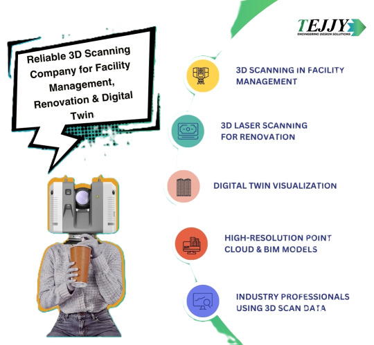
Looking for expert 3D laser scanning services near you? Our 3D scanning company specializes in facility management, renovation, and digital twin solutions with high-precision 3D building scanning services. While LiDAR scanning faces challenges like accuracy issues, data processing complexities, and limitations with reflective surfaces, our advanced technology ensures precise, high-quality scans. We overcome cost and equipment challenges to deliver reliable and efficient results. Contact us today for professional 3D laser scanning services near you!
0 notes
Text
Scanning the Biggest Rooster Hotel for Guinness Book of World Records (Drone LIDAR video)
Campuestohan Highlands Resorts in the Philippines is welcoming soon its new additional attraction: a gigantic rooster that is even bigger than its King Kong statue hotel. The resort owners are busy building it these days in great lengths as they wanted it to shine with awe-inspiring dea and, of course, to win the Guinness Book of Records for the largest cock hotel in Asia. One rule though is to…
youtube
View On WordPress
#biggest rooster holte#campuestohan highland resorts#construction#dji drone lidar laser scanning#giant cock hotel#largeest rooster statue in asia#lidar#tourism destination#tourist attraction near bacolod#Youtube
0 notes
Text
Exploring the Future of Technology: Lidar Vision, Robots, and Road Profiling
The technological landscape is rapidly evolving, and some of the most exciting innovations are rooted in advanced sensing technologies. Among these, Lidar vision, a laser-based system, is revolutionizing various industries, from robotics to road profiling. At the forefront of this change are companies like Red Sensors, offering innovative solutions to meet the growing demand for precision, accuracy, and efficiency. This blog delves into the key concepts of Lidar vision, its application in robots, its role in laser systems, and how it's transforming road profiling.
What is Lidar Vision?
Lidar, which stands for Light Detection and Ranging, is a cutting-edge technology that uses laser light to measure distances. Lidar vision refers to the integration of this technology with advanced imaging systems. By emitting laser pulses and analyzing the reflected light, Lidar creates highly accurate 3D maps of its surroundings. This allows it to detect obstacles, measure distances, and build detailed visualizations of objects in the environment.
Unlike traditional imaging technologies like cameras, Lidar can provide accurate depth perception even in low-light or challenging weather conditions. This makes it an essential tool in numerous applications, particularly in robotics and autonomous vehicles.
Lidar Vision for Robots
The integration of Lidar vision in robots has unlocked new frontiers for automation. Robots equipped with Lidar sensors can "see" their environment in three dimensions, enabling them to navigate complex spaces with precision. Whether it's an industrial robot on a factory floor or a robot designed to deliver packages, Lidar vision allows these machines to avoid obstacles, map their surroundings, and even collaborate with humans safely.
The Lidar vision for robots is particularly valuable in applications requiring autonomy and real-time decision-making. These robots can adjust their movements based on the continuous stream of data from Lidar sensors, adapting to dynamic environments without human intervention. This results in more efficient, effective, and safer robotic systems.
The Role of Laser Systems
At the heart of Lidar vision is the laser system, which plays a pivotal role in the emission and reception of laser light. Laser systems are designed to emit high-powered, precise laser beams that travel to objects in the environment and return as reflected light. The system measures the time it takes for the light to return, allowing it to calculate the distance to the object.
Laser systems are central to many technologies, from surveying to environmental monitoring. In the context of Lidar vision, these systems ensure that the data gathered is both accurate and reliable, contributing to the overall effectiveness of the technology in a variety of applications.
Road Profiling with Lidar
One of the most impactful uses of Lidar is in road profiling, a process that involves creating detailed maps of road surfaces for various purposes, including infrastructure maintenance and planning. Traditional road profiling methods are often time-consuming and prone to errors. With Lidar, road profiling becomes more efficient, with the ability to generate highly accurate 3D maps of roads and highways.
Lidar-based road profiling can detect minute imperfections in road surfaces, such as cracks or potholes, and provide valuable data for maintaining infrastructure. This technology is transforming how municipalities and companies approach road maintenance, reducing costs, improving safety, and extending the lifespan of roads.
The Impact of Lidar Technology
Lidar technology is not just a game-changer for robotics and road profiling; it also has applications in a wide range of industries. From autonomous vehicles to environmental monitoring, Lidar offers unprecedented accuracy in mapping and data collection. Its ability to operate in diverse conditions, such as night, fog, and rain, makes it a versatile tool for the future.
For companies like Red Sensors, the integration of Lidar technology into their product offerings ensures they stay ahead of the curve. With their advanced laser systems and Lidar solutions, they empower industries to harness the full potential of this groundbreaking technology.
Why Choose Red Sensors?
At Red Sensors, they understand the transformative power of Lidar vision and laser systems. Their commitment to providing high-quality solutions has made them a trusted partner for industries seeking to leverage advanced technology. Whether you're looking for Lidar solutions for robotics, road profiling, or other applications, Red Sensors offers the expertise and cutting-edge products you need to succeed.
For more information on Lidar systems and how they can benefit your business, visit Red Sensors today. They are at the forefront of Lidar technology, helping industries around the world navigate the future with precision and accuracy.
Conclusion
The future of technology is undeniably shaped by advancements in Lidar vision, robotics, and laser systems. From enhancing the capabilities of robots to revolutionizing road profiling, Lidar is paving the way for a smarter, more efficient world. Companies like Red Sensors are leading the charge, providing innovative solutions that make these technologies accessible and impactful across various industries.
0 notes