#northeast floods
Text
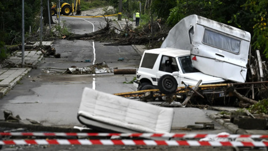
Why Cuba and Netherlands set an example for India in dealing with floods.?
Floods became a challenge after the monsoon rains in many states of India. This disaster is not new for the country.
Why Cuba and Netherlands set an example for India in dealing with floods.?
Floods became a challenge after the monsoon rains in many states of India. This disaster is not new for the country.
About five years ago, during the monsoon, the Mahananda River was in spate in Bihar. The flood proved disastrous for Kunti Devi and her family. The water carried away Kunti Devi's husband.
In the year 2017, the death toll from floods in India, Bangladesh and Nepal was more than 12 hundred.
After five years i.e. this year also the floods became the cause of destruction in many states of India.
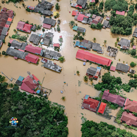
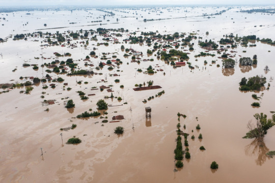
In Assam alone, more than two thousand villages in more than 27 districts were affected by the floods. Government figures have confirmed the death of more than a hundred people.
About 4 million people were affected due to floods in the northeastern part of Bangladesh.
This difficulty is not seen only in South Asia. Last year, cyclonic storm 'Aida' became a problem for America. More than 40 people died due to the impact of the storm.
Scientists around the world are warning that incidents of 'nature's wrath' may increase in the coming years.
But can the damage caused by it be reduced and deaths prevented?
Journalist Amanda Ripley explains, "I was doing a series on disasters for Time magazine. These included the 9/11 attacks, Cyclone Katrina, and other disasters. I found that the survivors of different types of accidents were largely were telling the same stories."
The stories Amanda heard weren't just about tragedy and loss. They also came to know how people react in times of disaster and how it can put them in danger.
Amanda says that most of the deaths during floods in developed countries are due to drowning. In most such cases, it has been seen that people were trying to cross the flood water or were driving in the middle of the water.
Amanda says that usually the brain is not able to correctly estimate the danger associated with water. People are unable to assess the power of flowing water and sometimes they overestimate their capacity. Actually, for many people driving in the middle of the rain is not a unique thing. They are not afraid of it and sometimes they get into trouble.
Amanda explains, "15 cm of water running as high as ankle height is enough to knock you down. 15 cm of water can stop a car. If there is 30 cm of water, then your car can float. 60 cm If there is water, you can flow. We probably don't even think that this much water can kill us."
Amanda also answers why we can't assess the situation properly.
She says, “There is a fear in our mind for situations like cancer or terrorism that we feel that we cannot control them, but something that we consider ourselves to be aware of or believe that we can overcome it. We can control it, as if we are not afraid of rain and we see danger differently.
Research conducted in developed countries such as the US and Australia has revealed that a certain group of people are accustomed to underestimate the risk.
Amanda says that men are more than twice as likely to die during floods.
One reason for this is that men are more likely to work in hazardous areas than women. One of the major reasons is men's habit of taking risks. However, not all men are the same in this matter. She says that "about 30 percent of white men see very little risk of driving in water."
The elderly are more alert to the dangers that lie ahead. But they can put themselves in trouble when they make decisions like leaving home during bad weather.
Amanda says, "I spoke to the family of an elderly person who died in Hurricane Katrina. They did not want to leave the house. They did not want to spend 20 hours in their daughter's car with children and dogs. Like he too was afraid to leave his house.
In difficult situations, many times people's decisions become the reason for their death.
Now the question is how to stop such deaths?
Amanda says that governments can inform people about the danger in advance. The warning should be clear, precise and detailed and should be repeated over and over again.
Flood prevention measures
Kees Bones, a specialist in water resources management, works for the Institute 'Deltares' in the Netherlands.
He says, "It might be surprising to people outside the Netherlands that we don't think about floods every day. Is."
Kees Bones, who seems careless about the flood, does not forget to mention that more than 50 percent of the GDP of the Netherlands comes from below sea level. In such a situation, if there is a flood in the western part of the Netherlands, then the economy here will be ruined.
He says that the people of the Netherlands have been working towards stopping floods for centuries. It started with the extraction of water through windmills and steam engines.
After the great devastation in 1953, the people of the Netherlands intensified efforts to deal with the floods. At that time more than 18 hundred people died due to floods.
Kees Bones explains, "It was a time of decision for the people of the Netherlands. After that the Netherlands decided to prepare a plan which we call the Delta Plan."
Large scale construction projects were made in it. Dams and barriers were built to stop the sea water. It cost about $6 billion. It took almost 40 years to complete.
But due to rising sea levels and climate change, it seems that the task of getting protection from floods will never be completed. For this a new delta law was made.
Keyes states that one billion euros is earmarked for flood protection every year.
In the Netherlands, most of the money is spent on building large projects. One of these is the 'Rotterdam Harbor Flood Barrier'.
He explains, "This is a storm barrier. It has two doors. Each door is as high as the Eiffel Tower. Its control is entirely computer-controlled. To close it, the flood risk is assessed. What is the level, what is the level of the storm. What is the level of rain, etc. It is a very hi-tech system."
The Netherlands has also made a lot of progress in terms of weather forecasting.
Kees Bones explains, "In the Netherlands, we want to have an accurate flood forecast of 10 to 20 centimeters. Even if you can't stop the flood, people have a chance to go to higher places. So that they can lose their valuables." Safe
Through these measures, the Netherlands has got great security. Keyes Bones says that he does not remember when the last death in his country was due to floods.
Keys Bones has also advised the Government of India. He says that in the year 2017, he had also warned the Bangladesh government a week before the floods.
Devastation and lessons
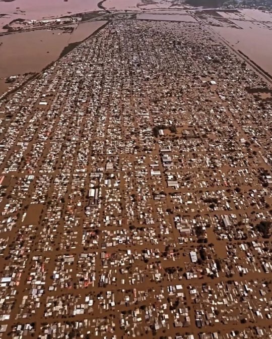
This year (in 2022) floods became the cause of great destruction in the northeastern part of Bangladesh. The deaths of many people, including small children, have been confirmed. More than 40 lakh people are homeless. Bangladesh faces the problem of floods almost every year.
Dr Ashraf Dewan, a specialist in weather and floods associated with Curtin University of Australia, says, "When I was in high school, it was 1988, when Bangladesh was in the grip of severe floods. About 61% of the country was under water for three months. Drowned."
A large part of Bangladesh falls in the world's largest delta region. It is one of the most fertile areas but floods are a permanent problem here.
Dr Ashraf says that floods cause major devastation in Bangladesh every five or ten years and the government spend more than 20 percent of its total budget on projects related to water management.
Dr Ashraf explains that sometimes these constructions give a 'false sense of security'. Considering the site close to the dam and other constructions as safe, people start settling there and are not aware of the dangers present there.
They say that here it is difficult to try the measures of rich countries like Netherlands. There is a need for cheap measures in Bangladesh. This includes accurately identifying the flood-prone area and making evacuation plans.
Dr Ashraf Diwan says, "You have to build more shelters for flood situation. If you can tell people that see this flood shelter is near your house. You can go here when there is a flood situation. "
The death toll during floods is decreasing worldwide. Due to better technology, accurate weather forecast is available. But still people will be surrounded by floods. It is also important to plan for post-flood situations. Many people get caught by typhoid during monsoon. The reason for this is contaminated water. Many people also face the problem of diarrhea and cholera during the monsoon season. I think by informing people the effect of these diseases and other problems can be reduced.
Dr. Dewan says that governments should suggest solutions for the future. Local people should also be included in the plan that is made. But is this happening?
On this question Dr. Ashraf says, "At present we don't seem to be doing this. During floods you will hear a lot of noise in the country but as soon as the flood water recedes, we all forget. We don't do anything that in future. Let us save people and property."
learn from cuban
Cuba remains an example for the world regarding the management of natural disasters.
"In the 1950s, when I lived there, there were a lot of tornadoes and great destruction," says Elizabeth Newhouse, advisor to the Cuban Program at the Center for International Policy, a Washington-based think tank.
Elizabeth now lives in America, but she grew up in Cuba and has seen what storms can do.
She says that she saw many storms in Cuba and her experience was very scary.
Sometimes change begins after a major accident. In the case of Cuba, this accident was the cyclonic storm 'Flora' of 1964.
Elizabeth explains, "Seven thousand people died due to the Flora storm. After that they adopted the civil defense system. It is headed by the President of the country. It is very effective. It covers every aspect of preparing to deal with the storm. Gone."
After this, the Comprehensive Emergency System was implemented. Elizabeth says that this is one of the best systems in the world. She says that very few people die in Cuba due to storms and floods and the reason for this is preparation. In schools, children are taught from a young age how to prepare themselves.
Every year drill means preparation is tested and then when the storm comes, everyone from big government officials to local volunteers work together according to the plan.
Elizabeth says that about 120 hours before the civil defense people start preparing. About 36 hours ago, they get into action rapidly.
During one of the most severe cyclonic storms 'Irma', Cuba showed the world what to do on such occasions.
"They started evacuating people 24 hours before the storm hit. Most people went to their friends and relatives' homes. The rest went to rescue centers. They were also accompanied by pets. Their household items could not be found if they were to be found," Elizabeth says. If there was any loss, the government would have compensated for it. So they were not worried about the goods. In such a situation, they did not face any difficulty in going to a safe place."
Elizabeth says that volunteers or officials provide help to the elderly, sick, pregnant women and all other people who cannot go to safe places on their own. Even if someone wants to stay, he is not allowed to stay in a dangerous place.
Elizabeth explains, "Their (Cuba's) record of saving lives is excellent. For example, in the event of a hurricane, Cuba has two deaths per 100,000 people. In the US this number is closer to 15. In Cuba Everything stays on track and it takes practice."
America and other countries also took cognizance of this. He sent disaster management experts to Cuba to understand how this small country managed to reduce the death toll during a natural disaster.
Coming back to the same question that how to prevent the deaths due to floods?
As our experts pointed out, accurate weather forecast can make a big difference.
In rich countries, it is possible to counter natural disasters through construction. But the Cuban approach can be effective for developing countries facing the problem of floods, lack of resources and climate change.
And plan, as our fourth expert, Elizabeth, says. teach people. This Cuban mantra will be useful in saving lives.
#floods#northeast#evacuate#latest world news#flooding#assam floods#northeast floods#prayfornortheast#learnfromcuba#cuba#culture#history#nature#cuban food#cuban revolution#cubano#panama#netherlands
0 notes
Text
i do not understand how it has rained here almost every day for a month. and it's going to rain for the next week too. bring the sun back i miss her 😔
#my posts#ik with climate change the northeast states will see more precipitation & flooding#but this is just absurd. monsoon ass behavior
3 notes
·
View notes
Text
the visual imagery of a partially drowned cemetery is extremely cool in theory as a showdown spot but as someone who lives on the gulf coast, a few hours from new orleans, i am so so so unnerved by the idea. thats floating corpses o'clock right there. that's the swimming dead. like maybe it's a historical cemetery so theres no actual bodies left but STILL. get them headstones somewhere else for the love of god
#the visceral southern reaction to seeing a partially submerged cemetery#why do you think theres so many mausoleums! because bodies sometimes FLOAT UP#it's a NIGHTMARE#i don't actually know what the authorities might do with historical cemeteries that get flooded permanently#enough to need a 'deep water' warning sign#i would HOPE they'd at least rescue the headstones. actually this sounds like a cool rabbit hole to fall down at some point#i wonder if caitlin doughty's ever covered this#brb about to go write some random barely-connected-to-canon owl house fanfic about. this random cemetery.#they have to be living somewhere in the northeast right? bc of the witch-hunting town?#so really where is all this water coming from unless they are RIGHT near the coast but it's all so wooded#if it's from torrential rains then the water should evaporate/sink in before a warning sign is necessary right?#idk i don't actually know jack about northeastern usa topography#ok its time to shut up now. it's time to shut up and do some research#or idk do something thats actually productive with my time#but i really wanna know about flooded cemeteries now soooooo#actually theres a historical cemetery behind my local library's main branch! i wonder if there's reference books about it somewhere#or if i can ask someone there hmmmmmmmm#YALL........ rabbit holes upon rabbit holes it's time to resurrect (lmao) my dormant interest in cemetery practices#see if any of my theories hold any water (lmao)
9 notes
·
View notes
Link
Flood situation in Assam:
The flood tide situation in Assam hardly worsened as nearly1.20 lakh people in 20 sections have been affected by it. According to the reports of the Assam State Disaster Management Authority( ASDMA), following torrential rains in Assam, other neighboring countries, and the neighboring country Bhutan, the water situations of several gutters are flowing above the peril position mark and submersed new areas. The water position of the Beki River is flowing above the peril position mark at Road Bridge, Pagladiya at Nt Road Crossing, and Puthimari River at Nh Road Crossing.
#flood#flooding#floods#flood in assam#assamfloods#flood in northeast#disaster#flood management#june 2023#flood control#alert#newsprovider#newsprovidernetwork#thegyaaneeknowledge
1 note
·
View note
Text
Sweltering heat lingers in the Northeast while flood threat returns to Kentucky - CNN
Sweltering heat lingers in the Northeast while flood threat returns to Kentucky – CNN
Sweltering heat lingers in the Northeast while flood threat returns to Kentucky CNN
Source link

View On WordPress
#CNN#flood#Heat#Kentucky#lingers#Northeast#returns#sweltering#threat#Weather#Weather forecast: Sweltering heat lingers in the Northeast while flood threat returns to Kentucky - CNN Video
0 notes
Text
Hello everyone. Climate change and lack of infrastructure has cause severe floods in the south of brazil and thousands of people are displaced or missing. If you can help, please do, especially those who use dollar or euro. You don't know far your money can take us
This tweet has a video showing how absurdly fast the water rose. Image if this was your home, completely taken by water in under three minutes. Imagine if you had children, elderly, disabled people living here. What would you do in this situation? What can you even do?

Most of the state is now underwater, and the parts that aren't don’t have power or water. Getting prescription meds and other necessities like hygiene kits and food is difficult because capitalism sucks. The military police are protecting supermarkets because the people are hungry and taking the food. Mind you, the food will spoil anyway. But god forbid people don't go hungry.
And in the midst of this chaos, public transport still isn't free. People are charging to rescue folks. So people can only be rescued by helicopter because of the currents. There are people debating whether or not they should leave pets to die.
And the government has done basically nothing. It is the government's fault, everyone knows this. The money that was supposed to go to preventing something like this simply doesn't exist. The people organizing rescues are distributing resources are the people themselves. Influencers have been doing more to the cause than the government at this point.
Some people were bringing up Madonna because the flood hit the night of her show, and they were saying the money she received should have gone to the affected people. And so she donated 10 MILLION reais. It is utter madness. There are bodies floating in the water people have to wade through.
If you can do something to help, please do
Here's a link to donate to an ngo that is feeding the displaced people
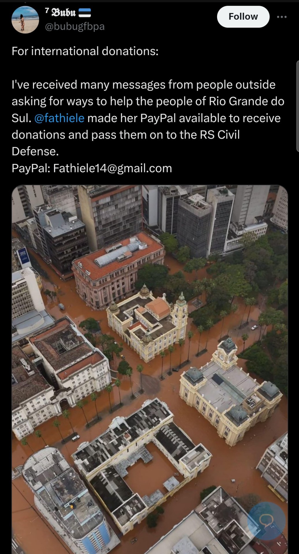
Paypal: [email protected]
Edit: Floods are also displacing people in the northeast, literally on the other side of the country. The situation is dire. Remember, you are closer to being a climate refugee than being a billionaire. If I find where you make international donations to help Maranhão I'll share it here
#brazil#rio grande do sul#climate change#global south#flood#enchentes#charity#ngo donation#climate refugees#brasil
227 notes
·
View notes
Text
You really should know about Storm "Daniel"
Unlike how much all of us Greek blogs notify our tumblr communities about the regular (at this point) arsons wildfires afflicting Greece, we did not say much about the floods the country has been suffering from right now. There was a mention here and there and I even made a joke post as the storm was starting but not a lot of stuff in general. So, I think there's a couple of things you should know and I feel like I could address about it and actually it's not just about Greece. So I believe this could interest a lot of people and it should be something known worldwide.
In the beginning of September there was an alarm about an extreme weather phenomenon forming above the Ionian Sea at the west of mainland Greece. In truth, the phenomenon was not caused by the climate change. It was just a very rare occurence where a high pressure atmosheric system was sandwiched between two currents of low pressure. Low pressure systems are the ones resposible for stormy weather while high pressure systems generally create stable weather. As the low currents encircled the high pressure system, the storm that had started forming became unusually stable for a storm. As a result, the storm moved northeast above Thessaly and other regions of the central part of Greece and... just decided to stay there for an indefinite amount of time. Furthermore, because it's September and the Ionian Sea had warmed up throughout the summer, the medicane (Mediterranean cyclone) gained tropical features as it was forming, pushing its intensity to extremes unknown to this area.
The storm remained above all of central Greece for about 4-5 days but at the meantime it was causing side-storms in neighbouring countries, such as Bulgaria and Turkey. Both countries suffered from floods causing damages and deaths.
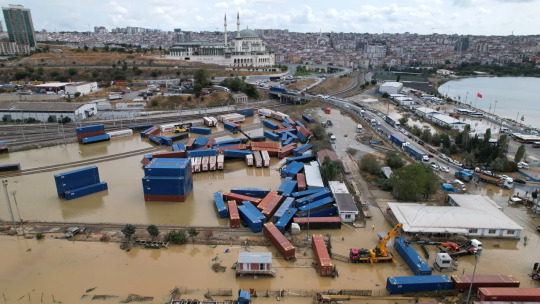
Istanbul, Turkey (CNN).
Tsarevo, Bulgaria (CNN).
Four people died in Bulgaria and seven in Turkey.
But like I told you the core of this was exactly on top of Greece's central mainland and islands. So what happened there? I happened to experience this shit first hand. My recollection of it is that it was unlike any other storm I had experienced before. My knowledge on meteorology is not very advanced, however I believe due to the high pressure part, there were actually no winds at all - or they were insignificant, so it wasn't like what you might have in mind as a conventional cyclone. It was a rainstorm but it was like a rainstorm from hell. The crucial part is that in Greece summer violent rainstorms may last for about five minutes but certainly not for five days nonstop. There was no pause, not even for a second. It kept pouring and pouring in indescribable volumes, without decreasing or slowing down, not for a moment. The fourth day it started taking short breaks.
As a person with a phobia of lightnings since childhood, I kept wearing earplugs throughout all these days. For four days, ten seconds did not pass without at least one lightning shrieking exactly on top of our heads. In the end, I am dead serious, I think my lifelong phobia has been cured somewhat due to this extreme exposure that eventually had a numbing effect. I think only the first day there was a record of 7,000 lightnings. I believe there must have been dozens of thousands overall. The lightnings also caused fires but the downpour was so overwhelming no fire could ever stand a chance.
Whether during or after the rains, what I was seeing outside was post-apocalyptic. The only thing missing was the zombies. It really looked like a background from a videogame, including a constantly lit up sky. I was not in danger though people dear to me were. The worst for me was a huge fall in the quality of living but that doesn't matter. The rains caused severe destructions across cities and villages. They caused floods, they broke bridges, they broke a massive number of roads, they made walls collapse, they destroyed springs, they damaged water and electricity outlets entirely, they drowned flocks and flocks of animals, they destroyed mountainous and coastal villages alike, they made cars float and fly over each other and they uprooted houses.

Village in Mount Pelion, Greece.
But that's not the end of it. Four days later, the storm moved southwest towards the Ionian sea, basically to the place of its original formation. It side-swept over Athens in the meantime, flooding the city, but that doesn't mean much since I could cry and Athens would still flood with my tears. Anyway. AFTER the storm left, the floods caused by it started multiplying and expanding. Picture that: a crystal clear sky, a bright sun and your phone screaming state alerts about evacuating your village or town because a lake has launched at you! Here's the thing: Thessaly is a massive plain surrounded by a ring of mountains. Half of those downpours fell right on the lowlands causing floods and destructions the first days. The other half however fell on the mountains, filled the streams heading down and they all met up and filled the lakes and the large river of Thessaly, Pineios and they all basically exploded the next days. Pineios especially exploded both in its western and eastern part, sinking the entirety of Thessaly's plains under water. As a result, floods were actively taking place days after the storm had ended and the weather was good. The phenomena have only started subduing since yesterday.

The overflowing of the river, trapped by the mountains.
Farmers won't be able to work this year and next year is questionable as well. There are huge concerns about various epidemics breaking out as more and more dead animals are found in the waters. Entire villages are under the water. There are estimations that some villages in west Thessaly might have been lost forever and their residents will have to move elsewhere. Sixteen people have died from the rainstorm and the floods.

Actual villages in Karditsa, Greece.
A more longterm danger is that the ground received such an unnatural amount of water that it might have been severely eroded and destablised, making it vulnerable to natural disasters I don't want to utter. Many roads are either broken or bloated and Thessaly has been cut out from communication and transportation with the rest of the country. To this day, there are maps guiding people how to drive from North to South Greece and vice versa by entirely skipping Central Greece! (Hint: they will have to drive through Epirus, aka western Greece.) The first days there was also complete isolation from what was happening in the country and the world and also the very regions we were in as we had no electricity and our only chance was getting a call from somebody being elsewhere and telling us what is going on.

Volos, Greece (CNN)
Many regions have received within 2-4 days 55 times their monthly amount of rain or more than twice the yearly amount. Greek meteorologist Christos Zerefos estimated that such a phenomenon occurs every 300-400 years. Meteorologists were alarmed internationally - with Germans and Americans reportedly saying they hadn't studied such a phenomenon again in their career. Its intensity was record high in the history of Greece and right in the top of Europe's as well. They also agreed that such a phenomenon would be devastating even if it had hit the most advanced and prepared country.
BUT THIS IS NOT THE END. The weakened Daniel seemed to slowly move towards South Italy but it decided to take a turn and headed south towards Libya and Egypt. Quite possibly, as the storm was once again travelling across the warm Mediterranean Sea, it was rejuvenated and gained even more tropical traits. Eventually, the medicane hit Libya with unprecedented force.

The cyclone travelling from Greece to Libya.
The toll it took on Libya is unspeakable. As I am writing this,
More than 5,226 people are killed and more than 10,000 are currently missing.
Like, can you wrap your head around what I am talking about? I don't see this shit being acknowledged enough across the world. I am checking this again and again, to ensure I am reading this correctly.
Daniel has officially become the deadliest medicane on record.
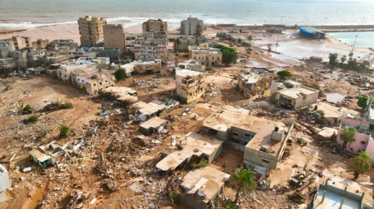
Eastern Libya, from Al Jazeera.
In the meantime, Greeks found opportunities to practice their favourite sport: political infighting. People who weren't even here when hell broke loose say that if this or that was properly done, we would not have problems at all. I even saw an idiotic Greek expat comment how "we got drowned in a little bit of rain". The truth is we should bloody thank our lucky stars and I say this with the entire awareness of half of Thessaly being currently underwater. It is true that Greek governments and people have done so many things badly, like building on top of streams and rivers, changing rivers' natural route, drying up natural lakes and all that shit that guarantees you are going to have massive problems once a serious storm breaks out. Also, the disaster revealed that there was once more a very questionable management of all the money given by the EU for anti-flooding measures after a previous flood (Ianos). Of course, I would be happy if at last we viewed this disaster as an opportunity to improve ourselves and the management of our land, however whatever happened these days wasn't the fault of anyone in particular. On the contrary, A LOT worse could have happened. A lot. Maybe Libya is not an indication because if Greece is not used to such extreme rain phenomena, then Libya is probably ten times less used to them, however we should not forget that this monster was STUCK at least five days over the heartland of Greece. For this alone we should damn be thankful we did not get it any worse and that the land endured in any way and of course now we have to correct old mistakes as well but let's do it united and determined and without wasting time once more in pointless infighting, which in this case might even be unfair. (In fact I think the thing we should blame the state the most about was not making it clear beforehand that this was going to be unprecedented, not just "very severe". They probably didn't want to cause panic and mayhem but still. We should know.) Of course I am not talking about how the state will treat the afflicted regions from now on, which is entirely its responsibility. And we should stand next to Libya. Greece has its wounds to mend but it should absolutely provide support to Libya. We know what this freak phenomenon was like.
I know this text is long but please consider reblogging this. We should know what happens on our planet. Thousands of people are dead from a freak phenomenon devastating regions across lands and seas. Also forgive any mistakes I might have made although I believe the information is correct for the most part. I didn't speak more about Libya because I don't know enough to analyze the situation as much. Perhaps there are ways of supporting the country too. As a last note, this phenomenon was not freakish because of the climate change - it was just a very unusual occurence. However, the - otherwise normal - warmth of the sea did feed and intensify the storm and the climate change might in the future cause these super rare, accidental phenomena to become more frequent.
#greece#libya#weather#climate change#storm#rainstorm#cyclone#flooding#natural disasters#world#tw death mention#world news#europe#africa#turkey#bulgaria#egypt#maps#storm daniel#greek facts#greek news#news#tw long text#tw long post#tw long#signal boost
783 notes
·
View notes
Text
More areas and populations have been affected in Assam, which is the most populous state in the country’s northeast. So far, 11 people have lost their lives and 600,000 people including over 78,000 children across 11 districts have been affected. An estimated 68,600 people have sought refuge in 187 relief camps.
The southern districts of the state, including the Barak Valley, have suffered more than the other regions. Landslides, floods and erosion have been reported from here and nearly 250,000 people are affected. Several trains have been canceled due to the rising water level in the rivers across the state. Additional personnel from the NDRF have been airlifted to the Barak Valley region to bolster the rescue and rehabilitation operation.
Mizoram has been affected more by landslides and storms than flooding. At least 29 people have been killed there with the highest toll reported from the capital city of Aizawl. Local NGOs such as the Melthum Local Council and Young Mizo Association have joined hands with the State Disaster Response Force (SDRF) for rescue and rehabilitation measures.
Chief Minister Lalduhoma has announced an allocation of 150 million Indian rupees ($1.8 million approximately) to the SDRF. Families that have lost kin in the disaster are being paid $4,792 each.
Meghalaya and Tripura have suffered less devastation compared to the other states in the northeastern region. Meghalaya reported five deaths and close to 5,000 people have been affected by storms and landslides. A portion of National Highway-6 that connects the state to Assam has collapsed near Lumshnong as storms and rains caused landslides. Transportation in the region has been severely disrupted. Vehicles were seen stranded in videos on social media.
In Tripura, around 2,500 people were rendered homeless and more than 550 houses were damaged due to the incessant rainfall, flooding and thunderstorms. Those rendered homeless have been lodged at 30 relief camps in different districts of the state. Sepahijala, Gomati, Dhalai and Khowai districts were affected the most by the cyclone. According to an official estimate, about 397 hectares of cultivable land belonging to 1,764 farmers were submerged by the flood in different districts.
122 notes
·
View notes
Text


Cities and towns across the Northeast USA are experiencing a rare June heat wave this week, with temperatures in the high 90s and humidity making it feel hotter. The heat index, which combines air temperature and relative humidity, is hovering at or above 100 degrees in cities like New York, Boston, Cincinnati, Pittsburgh and even as far north as Maine. This heat wave is occurring just as several environmental, healthcare and labor groups have asked FEMA to declare extreme heat and wildfire smoke “major disasters” like tornadoes and floods.
Source imagery: Planet / Nearmap / Airbus Space
65 notes
·
View notes
Text
Forget-Me-Not 1
Warnings: non/dubcon, and other dark elements. My username actually says you never asked for any of this.
My warnings are not exhaustive but be aware this is a dark fic and may include potentially triggering topics. Please use your common sense when consuming content. I am not responsible for your decisions.
Characters: Loki
Summary: You return to your childhood home to put the past to rest.
Part of the Backwoods AU
As usual, I would appreciate any and all feedback. I’m happy to once more go on this adventure with all of you! Thank you in advance for your comments and for reblogging.
You never really thought of Hammer Ford as home. You only ever tried to forget it and the turbulent years of your childhood. You let the memories haze away with the chaos of the urban rush. Office doors and honking cars easily overwrote the map work of your mind. A less than glamorous life, but peaceful. That’s all you ever wanted.
Your return is inevitable. You knew that. For years, you outran that fact. One day, you would need to face those dusty rural roads and the whispers in the wind. That day has come despite your stubbornness. A week after the news came and you could find no other excuse to stay away.
Not home, just the past. A piece of you you can’t erase. A shame you’ll never fully shake.
The welcome sign, beneath an iron statue of a hammer on a cloud, marks the village edge. You grip the wheel tighter and swallow dryly. Your bladder aches from the coffee you chugged after the last rest stop. You still have some ways to go.
Funny to think that despite its sprawling roads sparse layout, that the populace is so tight knit, the small hamlet untouched by the world outside. The same red barn up on the hill, the gate of the Grove in all its resplendence, and the short strip of businesses before the earth rolls into hills and flattens to fields.
You steer off into the northeast. The Maps app stopped working a few miles back. You don’t need the automated voice to guide you. It all comes back to you so clearly. Just around this curve and behind the barn, there’s the old path behind the Berrys. On and on, behind the overgrown brush to the house by the river.
Your tires mulch in the dirt as you brake. You shift and shut off the engine, looking out at the peeling wooden facade. The house was once a cottage in the glory days of the village, then it was passed along until your parents’ signed the deed. By that time, it was already derelict.
It hasn’t gotten better. The windows are cracked and dusty, the door splintered, and the front steps crooked. You get out and cross your arms, breathing in the damp forest air.
You feel nothing looking up at that shit hole. You thought the sight of it would bring the flood, but nothing. You shake your head. They said your mother was found in the kitchen, at the table with a bottle of vodka. You never expected anything different for her. At last, she’ll be happy. She’s off to see your father again.
You approach the porch but can’t make yourself climb the steps. There’s something blocking, some unseen wall. You just want to turn around, get in the car, and pretend it’s all a dream. Just like you had for all those years.
You lean your head back and blow out through your lips. Eventually you’ll have to go inside. You need sleep. You could curl up in your backseat again but your hips are ragged from last night. You’re supposed to meet Jan tomorrow. He’s got a casket ready and then you have to go to the church to discuss the service. You don’t think they’ll be much of one.
The hotel isn’t an option. Not for you.
As you glare up at the front door, you hear snapping sticks and the hum of another engine. You turn and watch the dark shadow slowly rolling between the trees. The forest green car turns in just behind your bumper and idles as you squint at the tinted windshield.
A curious villager isn’t unexpected. Everyone probably knows old Nadia is dead. You just hoped they’d leave you alone, at least until tomorrow.
You cross your arms and steel yourself. The driver’s door opens and a tall man steps out, his imperious nose sniffing the scent of river water and crinkling. Your chest feels as if it might gave in as his emerald eyes meet yours.
Loki Odinson. The last person you expected. The last person you ever wanted to run into. He turns and opens the back door of the car, reaching in and pulling out a basket of flowers. Your temper curdles up to the back of your throat. How dare he?
“My mother and father send their condolences,” he shuts the door and strides across the dirt. You look down at his leather shoes, should he be dirtying them here?
You just stare at him. You have no words, not that you’re much of a talker. What is there to say? Your mother’s dead and you’re stuck dealing with this dirt hole.
“Hm,” he angles past you and puts the basket on the top step, “should brighten the place up.”
You keep your arms crossed as you stare at him. He looks at you again, his eyes flickering, as if he’s surprised by your gaze. He just remembers the girl who kept her head down, the one with no voice and no backbone.
“Very sorry to hear it. Rather sad way to go. All alone.”
“Tell your parents, it’s appreciated,” you turn and march up the steps, dropping your arms.
You hear a scrape and shift to peek at his silhouette from the corner of your eye. He has his foot propped on the lowest step. The porch groans loudly under your weight.
“And I drove all the way here,” he says.
You shrug. You didn’t ask or expect it. That isn’t your problem.
He’s silent, waiting. He’s just like the rest of Hammer Ford, he hasn’t changed. He’s still the spoiled brat awaiting his prize. Well, you haven’t got one for him. You have nothing for him, no tears, no anger, just indifference.
“I see,” he says at last, “you must be tired from the road, no doubt. Of course, you’ve just lost a parent, I can hardly expect glowing conversation… not that I ever did from you.”
You don’t flinch. You go to the front door and pull out the key you dug out of your old jewelry box. It still works. You let yourself in as the hinges whine loudly. You don’t look back as you let the door clatter shut behind you.
There’s a lull before you hear the engine flip and hum. You stand, listening, waiting for him to be gone. Just like when you were young, hiding behind that door from that boy. Well, you’re both grown now.
#loki#dark loki#dark!loki#loki x reader#drabble#series#au#backwoods au#mcu#marvel#thor#avengers#forget-me-not
136 notes
·
View notes
Text
Suddenly, the ship began to shudder. Hirai got to his feet, found he could barely stand, and staggered out of his cabin, grasping the handrail as he pulled himself up the narrow stairway to the bridge. “Engine trouble?” Hirai asked the captain, who’d already checked and replied that everything seemed normal. The ship continued to tremble. Looking out from the bridge, the sea appeared to be boiling.
They turned on the television. An emergency alert showed that an earthquake had struck 130 miles northeast of their location. The shaking finally stopped, and in the silence, Hirai’s mind leapt to what would come next: a tsunami.
Hirai feared these waves more than most people. He had grown up hearing the story of how one afternoon in 1923, his aunt felt the ground shake, swept up her two-year-old brother, and sprinted uphill to the cemetery, narrowly escaping floods and fires that killed over 100,000 people. That child became Hirai’s father, so he owed his existence to his aunt’s quick thinking. Now, he found himself in the same position. He knew tsunamis become dangerous when all the water displaced by the quake reaches shallow water and slows and grows taller. The Ocean Link, floating in less than 500 feet of water, was too shallow for comfort.
In the family tree of professions, submarine cable work occupies a lonely branch somewhere between heavy construction and neurosurgery. It’s precision engineering on a shifting sea using heavy metal hooks and high-tension lines that, if they snap, can cut a person in half. In Hirai’s three decades with Kokusai Cable Ship Company (KCS), he had learned that every step must be followed, no matter how chaotic the situation. Above all else, he often said, “you must always be cool."
#please read this it is sooo good#infrastructure#engineering#another point in the very full 'society needs maintainers not heroes' column#longreads
55 notes
·
View notes
Text
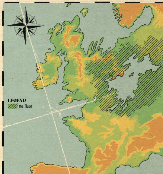


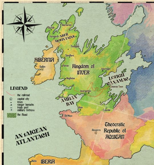
Inver - relief map relative to the continent with otherworld territory marked, broad habitat map, detailed local landmarks map, and political map of the northeast atlantic peninsula as of 1862
i was just having map fun for two days lol. i make habitat maps a lot already but the difference with this one is that i can't just download a handy shapefile and do some GIS magic. this was hand drawn (but obviously. somewhat traced over the actual irl map)
for the outline of the north sea coast i used bathymetry data to figure out where the true coastline would occur. the north sea recedes but the atlantic doesn't (to the same extent). because this landmass was formed through some ancient Event, i felt pretty okay about changing the bedrock because like, whatever, we can't be fully realist all the time. so the northern half of inver is mainly limestone, the southern half is silicaceous - so we got the bog/marl divide there, though lough cánamac (in volume slightly larger than any of the north american great lakes) appears to be the remnant of the north sea, it is freshwater with a relatively low pH. the water of the lough is black to dark brown due to the run-off from the southern bogs and swamps.
in the north, the mountain ranges are calcareous. calcareous grassland, scrubland, heaths and fens dominate with a largely alkaline profile. limestone marl lakes which regularly flood due to groundwater input make the region pretty unsuitable for crops other than rice.
the ruad is the name for a stretch of otherworld territory which contains the lough, though generally used to refer to the forested area. it is completely uninhabitable throughout the majority of its range due to the non-euclidian structure of the land making it impossible to navigate consistently, and the strange and frequently hostile creatures living there. the ruad is faery territory and belongs to an entity known as the Red King, who uses the symbol of a stag. so although inver may look like a large country compared to its neighbours, it has a relatively small population concentrated on the west coast.
however, sailing across the lough is the quickest way to trade with countries in the east, far quicker than trekking through the forest and over land. the trade route through the ruad from invergorken to the cánamac town is one of the most valuable in the continent. it consists of an old road with regularly-spaced ranger safehouses and patrols, and a newer pair of railway lines which can cut through the supernatural aura of the ruad due to their iron rails. the first and older line is no longer in regular use. it was constructed before the development of wrought iron and before the build crews learned how to blast through rock, so it takes a very slow and winding route and required a lot of maintenance. safehouses were constructed to board the workers while the tracks were laid. but without this original track, the construction of the second, far more advanced wrought iron track would have been impossible. workers for the second track were able to commute and sleep on the first track's train, keeping them from harm. the second track can fit two trains side by side and is in constant use ferrying cargo and passengers between the two towns
the country of inver, once The Event wiped out all of its original inhabitants a couple thousand years ago, was settled by hibernians and vikings from the north moving south, and aquitanians from the south moving north (thus the place names). the ruad mostly blocked incursions from the east. there was a long history of dispute over who truly owned the land, and that remained sort of up in the air for most of its history until the 1400s when armorican warlords (like Olivier) decided to make it theirs for realsies and waged war against their old hibernian trade partners (like Finbarr) for control of the land. the hibernians lost because finbarr fucked it up at the last second, and this cemented a ruling class of werewolves in inver until the 1860s
inver consists of three large duchies which cover 70% of the population. Moya in the west is the heart of lycanthrope rule, everybody worships a faery known as the immortal hound and the ruad is far enough away that it is not a fact of life as it is for everyone else. Inver duchy covers the capital city and the south-western farmland, the main sites of production in the country. And Cánamac duchy covers the trade port in the lough and surrounding territories, where forest clearing has led to new farmland and a thriving population. There was a fourth duchy in the north, Aber, but it was historically somewhat isolated and cut off from the south of the country and had developed its own customs and traditions, and its own form of the country's currency. In the 1840s, the duchy of Aber was dissolved and reconstituted into the king's lands, and southern customs were enforced in the north to prevent any more divergence. the palaces of the ruling families in each territory are shown in the local map alongside the family names.
Due to The Event causing massive damage in this region of Europe, forbidding the development of britain and france etc as colonial empires, the last great Empire of this continent was the roman empire, and even that didn't manage to overcome the Ruad. technology is rudimentary in Inver and the people living there are largely considered to be weird backwards superstitious barbarians. aquitan has been threatening annexation for decades, led mainly by the church of suzette, which forbids interaction with otherworld entities. the church holds in disregard the nobility of inver and their cultish ways, and as a result has been banned from attempting to convert inver citizens. but the church is still allowed to make minor inroads into inver for one very important reason: penicillin and antibiotics are the sole creation of the church, and the secret of how they are made is unknown outside suzette. so for the sake of good, advanced healthcare, the church is allowed to set up clinics and hospitals, on the condition that nobody is converted, and members of the church are strictly banned from engaging in any business but importing and selling antibiotics
#ignore me using the wrong orthography in several places#setting: inver#northeast atlantic peninsula bro what happened to u... oh no.. he died...#none of that is spoilers under the cut it's just like. basic history everyone knows
526 notes
·
View notes
Text
How To Save Your Old Shit After Floods
Hi, Tumblr. My reach is small and I am but a poor archivist who can't afford Blaze, so please boost this.
Author's note: I hate to have to add this, but cultural heritage is inherently political and this made it to TERFblr somehow so... The author is nonbinary. Go get your own archivist to teach you if you're gonna be like that.
The west coast of the US is flooding, and while it might seem unimportant in the face of people dying, getting stranded, and being without power, a lot of people are also going to lose personal history to flooding. This gets talked about a lot in the context of hurricanes, but we should all know what to do to save our pictures and documents, too.
FEMA has a good cultural heritage rescue guide here: https://www.fema.gov/disaster/recover/save-family-treasures
You can contact emergency conservators for advice here: [email protected]
The Northeast Document Conservation Center is also invaluable: https://www.nedcc.org/free-resources/preservation-leaflets/overview (check out the Emergency Management section)
Knowing what to do before it happens is crucial to actually saving things. Read this stuff now! Like to save! Bookmark it! Screen cap it! Idc but keep it handy (and remember you might not have online access when you need it)!
The FEMA guide does a really good job at explaining how to dry things, but the basics are:
Separate, separate, separate. While it's still wet if you can do so without causing further damage. Salvage color photos before black and white, paper backing before plastic film. Pre-gelatin silver (black and white on paper) photographs (collodion, ambrotype, cyanotype, etc.) get priority, but most people don't have those. Remove items from frames of they show signs of water damage. Take off dust jackets, unfolder documents, etc.
Rinse with clean, bottled water if there is mud or other debris. Use a dish pan, fill it with a little water, and slip photos in carefully for a short little bath. Dip, dip, dip if you need a little agitation to remove mud, but don't wipe or swish (unless it's REALLY stuck and you're okay with the possibility of damage). Change your water often, and try to avoid agitating things or touching the image side. It is recommended to hold books closed to protect the textblock from more water when you rinse. Obviously, don't soak things. Photos are probably your most fragile material and can be submerged for up to 48 hours before it gets really hard to save them, so you don't want to add to that time.
Spread it all out. Get creative with how you keep things apart. Hang things if they can take the strain, but remember that the corners are the weakest points of paper and photos. Books can be tented on clotheslines if the binding is still sturdy (pages aren't coming loose. If they are, see the next point)
Interleave books with paper towels every 1/4 inch of pages or so. If you can, fan them out and stand them upright. Change the paper towels as they get damp (and idk, use them for cleaning tasks. Shit's expensive)
Get air moving. Indirect airflow from a fan is best. Avoid fluttering. I face my fan into a wall or upwards to diffuse the air flow.
Some staining is likely. Dried mud can be brushed from paper like book textblocks but shouldn't be brushed from photographs, so rinse photos first.
Photograph materials while they're wet and still intact. If you should lose something while salvaging, at least you have a photograph of it so it's not lost forever.
If you cannot dry things immediately, wrap individual items or small clumps that are stuck together in wax paper (ideally. Parchment can work, plastic wrap or ziplocs if you have to) and PUT IT IN A FREEZER. Not an ice chest. The goal is to freeze the water, and ice chests will soak it. Freezing buys you time. It halts water damage until you can deal with things. When it's time to dry, unwrap your items and allow them to fully thaw before even thinking about separating them.
If you find mold, quarantine those materials in sealed plastic bags and freeze. You need professional help. It is not worth getting sick because you tried to clean mold without appropriate protection!
ETA: These techniques also work on that book you dropped in the bathtub or spilled a soda on, just sayin'.
Again please feel free to share this! Fellow conservators, GLAM professionals, or those who have been there, done that, feel free to add to this! Thank you!
Edits:
This was hiding in the tags and is also a good practice! Preparation is key to reducing damage. Which reminds me--store the good stuff on your highest shelves. It won't help in cases like Hurricane Katrina, but a minor-to-medium flood probably won't reach!

#floodcleanup#flooding#California#conservation#photography#the archivist#yes im tagging magnus tags bc you people are fiends so rb to be a little archivist too#the magnus archives#libraries#bookblr#fan fiction#museum#diy#books#shelfie#archive#ok to reblog#climate change#ao3#stranger things#lgbtqia#signal boost#the mummy#poetry#artwork#art#disaster response#disaster relief#disaster recovery#hurricane
446 notes
·
View notes
Text
As a local Jim defender I can't resist making another post about him. Because I feel like we haven't talked about his background and how it defines him. Or we haven't talked about it enough, at least.
We know Jim is poor. We know he is gay. But what's more, he's a poor gay man from Isaan. Isaan in the northeast is the poorest and least developed region in Thailand. Even though one third of the nation's population live there, it only contributes ten per cent to the annual GDP. International tourism in Isaan is minimal, less than three percent of Thailand's mighty tourism income going there. Like Jim's family, many people still get their income from farming, but the infertile soil and the weather characterised by long periods of droughts and flooding make for harsh farming conditions.
Each year two million people leave Isaan to look for work in Bangkok and Pattaya where they make up the majority of the lowest paid workforce. Jim is one of those people. Neither Jim nor Wen are Pattaya natives, but how they ended up there is not the same. Wen saw a job opening and applied. He came for a change of scenery, to see what else is out there. He could've as well stayed in Bangkok and find a job there. Jim came to escape poverty. He didn't have a job waiting for him. The social network he has now he's had to build all by himself. Jim came to Pattaya to build a better life for himself, and just as it was within his grasp it got ripped away from him. His Pattaya dream failed. And yet he kept going, even took in his nephew.
We always say how relatable characters are when they log in to take the Am I Gay quiz. But like, growing up in Isaan in the 90s Uncle Jim did not know what the Am I Gay quiz is or have the means to access it. So can the man please catch a break on tumblr dot com!!
Uncle Jim is a survivor and on him the moon doth shine!
273 notes
·
View notes
Text
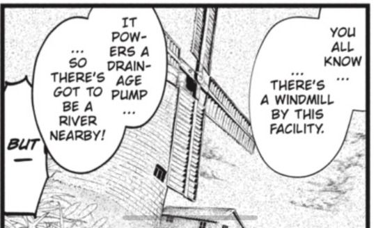
Ch210, Where is F. O. L. Orphanage?
⚠️ long post ⚠️
I was discussing that question with @juxl25, and I think we came up with a good choice for its location.
The only information we know for sure is that it's in Norfolk, and that it's near a river. We also know Finny and Snake took a train to a nearby town and walked to the orphanage.
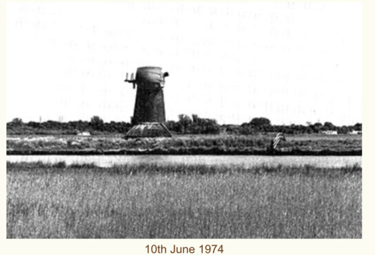
We also know there's a wind pump that drains water from the surrounding marshland. There are at least four major rivers in the area used for draining the marshes: Yare, Bure, Wensum, and Ouse.
Juxl25 suggested River Yare and the historic Red Mill (the wind pump) as the area but was looking at Manor House, which is farther away, in the village (proper) of Haddiscoe, Norfolk. After some digging around, I agree with River Yare and Red Mill/Langley Detached mill (originally called Langley detached windpump...
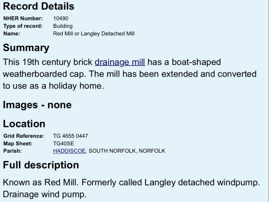
...or Langley Detached drainage pump).
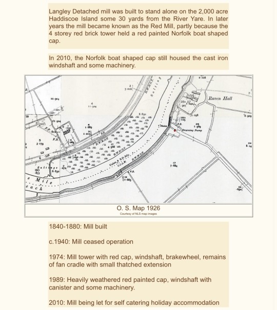
They are in an area northeast of Haddiscoe village, called Haddiscoe Island (these days), thanks to a canal added to connect River Yare and River Waveney farther inland, creating an island of the area and making the marshland there more remote/less accessible.
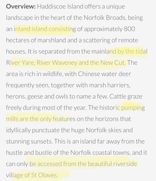
There's a historic farmhouse just east of River Yare, not far from Red Mill, called Raven Hall. And Raven Hall would be a premium location to have a secluded facility like F. O. L. Orphanage.
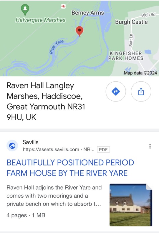
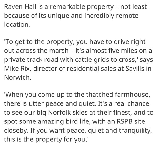
There's only one thing I don't like about the buildings shown for Raven Hall -- it's a bit farther from the drainage pump than I want it to be, and it's just a large farmhouse (almost 3000 sqft) and a long barn (almost 900 sqft). But there's a cool space just south of those buildings, which would be ideal for the main orphanage, as well as a spot for the stables/barn leading closer to the drainage pump, farther south. Here are two options for the placement of F. O. L.:
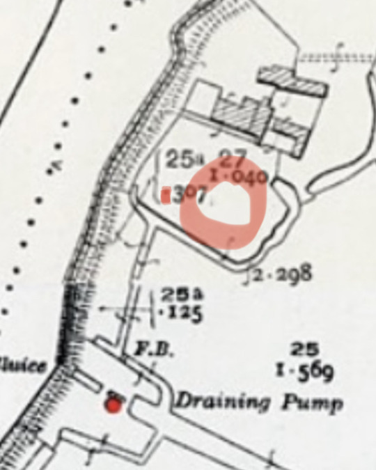
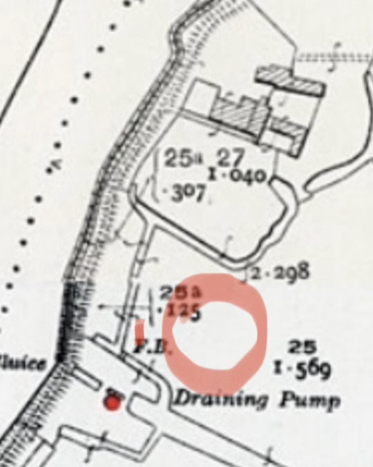
In each case, I've placed the stables to the west of the main house, as a small red rectangle (more or less), while the windpump was already marked by a red dot farther southwest. Looking at the bend of the river on Theo's image of a map of the place, the placement on the right (above) might be the better match. Then again, it could be exactly where Raven Hall is located. And Raven Hall, having been built in the 17th century (or at least 1700), is older than Red Mill (built in 1840).
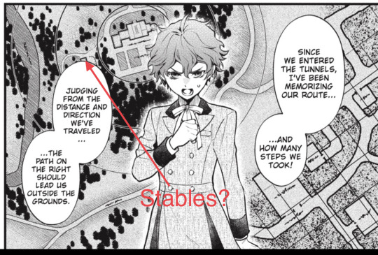
Too bad I can't see the placement of the windpump on his map, but I think it's somewhere behind the speech bubbles on the left side of the panel.
We see that the windpump at the orphanage has a low roof of some kind, and juxl25 explains that someone was probably living onsite just to maintain it full time. I did find at least one pic showing Red Mill with what could be the old maintenance shed/shelter, but it seemed to be on the wrong side. Who knows? I guess it depends on which way the sails are facing to catch the wind? But the low roof in the panel is probably just the top of some shed.
Oh, and near St Olaves, there's a train station called Haddiscoe Station. They could have got off the train there and made their way north to the orphanage by foot. Or did they hitch a ride part of the way? I'll have to go back and check.
I'm still considering one other location, not far from there, but I won't post it unless further research looks more promising.
Hey... can you imagine if all this time... F. O. L. was just some place name reference... like "Farmhouse on Langley" (Marshes)?!?
Please let these kids break the windpump and flood the tunnels.... 🙏
#black butler#kuroshitsuji#ch210#real places#historical references#norfolk#haddiscoe island#langley marshes#red mill#langley detached drainage pump#langley detached mill#langley detached windpump#theo#theodore#raven hall#theories#ideas#discussion#observation#long post#long reads#mar 19 2024#haddiscoe station
34 notes
·
View notes
Text

Roman Gem Engraved with Mythological Figure Discovered in Italy
During excavations at Lio Piccolo (Cavallino-Treporti), conducted by Ca’ Foscari University, a precious agate stone carved with a mythological figure was found in the flooded site from the Roman period.
Researchers found the ancient piece of jewelry during an excavation dive in Lio Piccolo, a village just north of Venice city.
The cut agate gem is engraved with a mythological figure and is considered an unusual artifact, particularly in an underwater environment. The high quality of the jewelry suggests that wealthy Romans visited the area.
Professor Carlo Beltrame, who led the excavation alongside Dr. Elisa Costa, said in a statement that it was a rare find, especially in an underwater environment.

“In a lagoon environment it is a rather rare find, to date we have news of two other precious gems found in Torcello and at Barena del Vigno,” Beltrame said.
Lio Piccolo used to be, and remains, a thriving fishing area. The underwater excavations have helped archeologists to understand the history of the area.
A structure with a brick base and oak walls from the first and second centuries CE sits 11 feet below the water’s surface. Initially, researchers thought it was used for oyster conservation and farming, but it was later determined to be a holding tank for oysters prior to consumption.
“Alongside this system there is a brick paving laid on poles, many fragments of valuable frescoes and some fragments of black and white mosaic which, in the 1980s, prompted the discoverer of this site, the amateur archaeologist Ernesto Canal, to interpret it as a prestigious villa,” Beltrame said. “The basin and the floor plans offer a precious marker, because they are well dated, for the study of the variations of the sea and of the local subsidence.”
Lio Piccolo is less than 10 miles northeast of Venice.
By Leman Altuntaş.

#Roman Gem Engraved with Mythological Figure Discovered in Italy#Lio Piccolo#agate stone#ancient artifacts#archeology#archeolgst#history#history news#ancient history#ancient culture#ancient civilizations#roman history#roman empire#roman art
99 notes
·
View notes
Last Seen Blogs