#quickmap
Explore tagged Tumblr posts
Visit Tumblr Blog
Explore Tumblr blogs with no restrictions, modern design and the best experience.
Last Seen Tumblr Blogs


Fun Fact
70% of Tumblr users say the Dashboard is their favorite place to spend time online.
Text
English culture guide map

English culture guide map English culture guide map, a quick reference navigation guide of this blog, the world of English, to give the visitors a rapid view of the different contents. English Culture blog summary pages | The World of English (english-culture.com) -- Advertising & Media -- Anecdotes & Quotes -- Arts and Crafts -- Blogs and bloggers -- Carl William Brown -- Celebrities & Gossip -- Copyright & Privacy -- Daimon Club -- E-books Promotion -- Education first -- Entertainment -- Essays with Quotes -- Facebook & Twitter -- Finance & Trading -- Fashion & Life Style -- Fort Attack Project -- Gastronomy & Food -- Grammar and Tests -- Health & Wellness -- Humor & Jokes -- Information News -- Knowledge & Culture -- Language & Grammar -- Literature & Life -- Marketing & SEO -- Music & Dancing -- News & Events -- Philosophy -- Photo Galleries -- Poetry & Poets -- Proverbs & Sayings -- Quotes by Authors -- Quotes by Arguments -- Reading & Writing -- Science World -- Sponsors & Partners -- Stupidity Struggle -- Technology -- Tourism & Travel -- Thoughts & Opinions -- Video Galleries -- Visual Quotes -- World of English https://www.english-culture.com/the-world-of-english/ The World of English is a website dedicated to exploring the language, culture, varieties, and future of English. It provides information on the history of English, its influence on other languages, its use in different fields, and its status as an international language. It also provides resources for learning, practicing, and improving English, as well as advice on using the internet and marketing strategies. https://www.english-culture.com/entertainment/ Entertainment is a form of activity that holds the attention and interest of an audience or gives pleasure and delight. It can be an idea or a task, but is more likely to be one of the activities or events that have developed over thousands of years specifically for the purpose of keeping an audience’s attention. "What masque? What music? How shall we beguile the lazy time, if not with some delight?" William Shakespeare https://www.english-culture.com/web-software-guide/ Web software guide links. This page contains a complete collection of links to the most useful software online, both old, new and future, with many AI applications and tools for every purpose, use and enjoyment.

Video shorts quotes https://www.english-culture.com/photo-galleries/ Great photo links to the most famous and useful website that offer free images. Photo Galleries by English-culture on Instagram, pictures, photographs, images and quotes by the Daimon Club Crew, Fort Attack and Carl William Brown founder of The world of English and Aforismi Celebri. The image of life is but the negative of that photograph that will only be developed by death. Carl William Brown https://www.english-culture.com/video-shorts-quotes/ Video shorts quotes, a post where you can find video shorts of various character also created with AI reciting various quotes and aphorisms by Carl William Brown. The end of all our exploring will be to arrive where we started and know the place for the first time. Thomas Stearns Eliot ~ We are all born ignorant, but one must work hard to remain stupid. Benjamin Franklin ~ The most intelligent recedes. The world domination of stupidity is based on this sad truth. https://www.english-culture.com/quotes-world/ Quotes World is a website that provides quotes and aphorisms from famous authors, philosophers, and other influential people. It also provides information on the history and meaning of aphorisms, as well as advice on how to choose the best quotes and aphorisms. Quotes World also offers a variety of topics, such as freedom of speech, happiness, life, love, and more. From this page you can reach other sections, such as quotes by authors, quotes by arguments, and quotes by Carl William Brown

Daimon Club Organization https://www.english-culture.com/100-best-quotes/ 100 best quotes and aphorisms by great and famous authors and writers edited for the World of English blog by Carl William Brown. Quotes include: "In tristitia hilaris, in hilaritate tristis" by Giordano Bruno, "The path to paradise begins in hell" by Dante, "We fight against three giants, my dear Sancho: “injustice, fear, and ignorance”" by Miguel de Cervantes, "Never accept an inferior position to anyone" by Miyamoto Musashi, "Today is the first day of the rest of your life" by Zig Ziglar, "We learn from history that we do not learn from history" by Friedrich Hegel, "All war is a symptom of man's failure as a thinking animal" by John Steinbeck, "Everywhere I go I find that a poet has been there before me" by Sigmund Freud, and "Smart people learn from everything and everyone, but stupid people already have all the answers" by Socrates. https://www.english-culture.com/ai-guide-to-web-resources/ A guide to the many AI resources available on the internet, including databases, general resources, texts, chats, software, books, services, voice and music, images, graphics, videos, online tools, and games. It includes links to websites such as The World of English, There's An AI For That, Andi Search, Perplexity Open Search, Google Translate, Microsoft Translator, Ahrefs, QuillBot, Books.Google.com, InstaText, DoNotPay, Notion, AISEO, Natural Readers, Eleven Labs, Descript, Riffusion, Stable Diffusion, D-ID, Brandmark, MyCharacter, Beautiful.ai, Zoomscape, Waymark, Tome, AITWO, Durable, ToWords, Sloyd, AI Dungeon, and AWS. https://www.english-culture.com/daimon-club-organization/ Daimon Club is a cultural association founded in 1997 by Carl William Brown to promote his literary works. It is a virtual meeting place made up of more than seven hundred pages, concerning almost every sort of subject. The name “Daimon” has a Greek origin and means “genius” or “spirit”. The main goal of the association is to improve communication abilities and to promote surrealism. The organization offers various services such as cultural research, free exchange of promotional links, translations, and consultations. It also sponsors campaigns against HIV virus and AIDS, and encourages dialogue between the two cultures, humanities and science. The Daimon Club also has a project to create an international operating center for the organization.

The Royal Society https://www.english-culture.com/proverbs-and-sayings/ Proverbs and sayings are wise words of wisdom that have been passed down through generations. They are often short and simple, and express a truth based on the practical experience of humankind. These great quotes can be used to express both the wisdom and the stupidity of different cultures and peoples. They are often used to give advice and guidance, and can be found in literature, poetry, and everyday speech. https://www.english-culture.com/origin-of-proverbs/ Proverbs are ancient words of wisdom that have been passed down through generations in many cultures. They are typically short, pithy sayings that express a general truth or moral lesson. They are often found in the Bible, Aesop's Fables, and other works of literature. They can be used to teach moral lessons, provide inspiration, and serve as a practical guide to living a better life. https://www.english-culture.com/autonomous-learning/ Successful language learning entails learner motivation, cooperation and empathy. This approach places emphasis on learner development. Autonomous learning is the process of learning without relying on formal education systems. It involves self-motivation, self-monitoring, and self-assessment. It can be done through reading books, exploring the world, and engaging in activities that promote self-learning. This process can be enhanced through peer-checking, producing materials, and reflecting on usage. It is important to provide learners with tips and assistance when needed, and to avoid “denouncing” them for making mistakes.

Finance and Trading https://www.english-culture.com/english-grammar-summaries/ English grammar is a complex and confusing set of rules based on Latin, with many variations in dialects and regional differences. It is important to understand the rules of grammar and to treat the English language with respect as an intricate tool. Quotes from various authors are provided to illustrate the importance of grammar and the complexity of the English language. A list of resources is provided to help with learning English grammar, vocabulary, and usage. From this page you can reach a lot of others posts and links about the English language, its grammar with lots of tests. https://www.english-culture.com/anecdotes-quotes/ Anecdotes and quotes are a great way to learn about English culture and the world. Famous writers and characters have told and narrated a lot of great works of art using this literary form. Some famous anecdotes of this page include the conversation between a mother and daughter, the story of Picasso, the story of the Michigan Grayling. Isaac D'Israeli's book A Dissertation On Anecdotes is a great resource for learning more about anecdotes and quotes. https://www.english-culture.com/literature-life/ Literature and life are closely intertwined. Literature can be used to teach, move, and entertain. It can also be used to transcend reality and provide insight into the human experience. There are many resources available to explore literature, such as Anna's Archive, PDF Drive, and WORLD BOOKS IN THE NET. Additionally, there are many quotes and aphorisms on books, poetry, and literature available to explore.

Britannica Online https://www.english-culture.com/thoughts-and-opinions/ Thoughts and opinions, ideas, reflections, intellectual speculations and considerations on different literary and social cultural topics by various and famous authors shaped on their cultural experiences. Quotations from influential people can be used to create valuable speech and writing. Quotations can help to express ideas better, evoke emotions, and show knowledge. Quotations can be used to discuss topics such as religion, philosophy, language, history, anthropology, astronomy, literature, poetry, and love. https://www.english-culture.com/great-philosophy-quotes/ Philosophy is a battle against the bewitchment of our intelligence by means of language. Ludwig Wittgenstein. If you don’t like my principles, I ‘ve got others. Groucho Marx. To be is to be perceived. (Esse est percipi). Bishop George Berkeley. The aim of philosophy is to show the fly the way out of the bottle. Great philosophy quotes include: "The secret to happiness is to face the fact that the world is horrible," by Bertrand Russell; "We feel that even if all possible scientific questions be answered, the problems of life have still not been touched at all," by Ludwig Wittgenstein; "The only true wisdom is knowing that you know nothing," by Socrates; "The aim of philosophy is to show the fly the way out of the bottle," by Ludwig Wittgenstein; "The only reason for time is so that everything doesn't happen at once," by Albert Einstein; and "The effort to understand the universe is one of the very few things that lifts human life a little above the level of farce, and gives it some of the grace of tragedy," by Steven Weinberg. https://www.english-culture.com/poetry-and-poems/ Poetry is an ancient and widespread art form that has its origins in the communal expression of the religious spirit. It is a form of imaginative literary expression that makes its effect by the sound and imagery of its language. It is characterized by compression, extensive use of imagery, and a strong emotional component. It covers a wide range of topics, from hymns and lullabies to love songs and political satires. It is often used as a form of communication or instruction, but it is also an art form in its own right. It has been adapted to many different cultures and times, and technological advances have made it possible to preserve any poem.

Autonomous learning https://www.english-culture.com/essays-with-quotes/ Essays with quotes. This article provides a list of classic essays and speeches from some of the world's greatest authors, including Walt Whitman, Virginia Woolf, George Ade, Susan B. Anthony, Robert Benchley, Joseph Conrad, Frederick Douglass, W.E.B. Du Bois, F. Scott Fitzgerald, Ben Hecht, Ernest Hemingway, Martin Luther King Jr., Jack London, H.L. Mencken, Christopher Morley, George Orwell, Dorothy Parker, Bertrand Russell, Margaret Sanger, George Bernard Shaw, Henry David Thoreau, James Thurber, Anthony Trollope, Mark Twain, H.G. Wells, and Walt Whitman. https://www.english-culture.com/latin-influence-in-the-english-language/ Latin influence in the English Language and vocabulary through the centuries. Latin has had a significant influence on the English language, with estimates of native words (derived from Old English) ranging from 20%–33%, and the true percent of native words used in everyday spoken and written English actually ranging from 75%–90%. A computerized survey of about 80,000 words in the old Shorter Oxford Dictionary (3rd ed.) estimated the origin of English words as follows: Langue d'oïl, including French and Old Norman: 28.3%; Latin, including modern scientific and technical Latin: 28.24%; Germanic languages: 25%; Greek: 5.32%; No etymology given: 4.03%; Derived from proper names: 3.28%; All other languages: less than 1%. English has borrowed extensively from Latin, with loanwords dating from the period before the Germanic tribes invaded England, and continuing throughout the Old and Middle English periods. Read the full article
#AI#authors#blog#club#contents#culture#daimon#Education#English#entertainment#grammar#guide#humor#hunmour#language#links#map#Navigation#poems#quickmap#quotes#resources#Science#summary#tree#view#world
2 notes
·
View notes
Text
Un modello al computer aiuta a sostenere la teoria dell'asteroide Kamo'oalewa come ejecta dalla Luna
Posizione e topografia del cratere lunare Giordano Bruno. A sinistra, una mappa del farside lunare realizzata con la Lunar QuickMap. A destra, la mappa topografica del cratere GB ricavata dai dati della Lunar Reconnaissance Orbiter Camera (LROC). Un piccolo team internazionale di scienziati planetari ha trovato prove a sostegno della teoria secondo cui l’asteroide vicino alla Terra Kamo’oalewa è…

View On WordPress
0 notes
Text
youtube
Fantasy Grounds Unity 4 5 0 Quickmap Feature
The new version is live.
0 notes
Text
Quickmap services plugin qgis

#QUICKMAP SERVICES PLUGIN QGIS INSTALL#
#QUICKMAP SERVICES PLUGIN QGIS OFFLINE#
#QUICKMAP SERVICES PLUGIN QGIS OFFLINE#
Then choose Add Themeand name it Offline Satellite from the Map Themes menu. For example, to set up a map theme for just the Offline Satellite layer the study area and your point layer, you would just turn those three layers on. Clicking the eye icon at the top of the Layers Panelwill open the Map Themes menu. These allow you to have different views of your map. When they have been created you can use the Browser Panelto add these to your map. You will need to experiment with the zoom level settings. You can set the extent to that of your study area layer. However, if you anticipate losing cellular connection out in the field, you can use the Generate XYZ Tiles (MBTiles)processing tool to create offline versions of each basemap. If you have a cellular connection the basemaps will work fine. (At the moment Input does not support the zipped default QGZ project file format.) Creating Offline Basemaps Save your QGIS project as a QGS file into the same folder. Here I have used to Simple markers to create a purple target icon. When saving, choose Add New Layerso the layer is added to the existing GeoPackage. (Although not in the screenshot below you can also choose to add a date column - type = DateTime.) When you have added each field click OKto create the layer. For each new column, enter the name, set the Type , Maximum length and click the Add to Fields listbutton. Before clicking OK you will add columns to record the data you will collect. Name the Table infrastructure and set the Geometry type to point. Repeat the above steps to create a point layer and save it into the same GeoPackage. Create a second layer into which you will record points out in the field. This study area covers a school and park near my office. Here I gave the polygon a Fill Style of No Brush, a Stroke Colorof bright red and a Stroke Width of 1.26. Styling the Study AreaĬlicked F7 to open the Layer Styling Panel. Use the Add Polygon Feature tool on the Digitizing toolbarto trace your study area. Right-click on the layer and choose Toggle Editingfrom the context menu. Now that the study area has been created, the polygon for the study area can be digitized and then styled. Save the Database (*.gpkg) into your folder.From the QGIS menu bar choose: Layer | Create layer | New Geopackage Layer. You will set up a layer as the study area boundary.
#QUICKMAP SERVICES PLUGIN QGIS INSTALL#
Install the QuickMapServices plugin and add the OSM Standard and Google Satellite basemaps.Open QGIS (in this example I’m using v 3.8).(Note: this post was inspired by the well done video by Dr. Here I will walk through the steps in setting up the same type of data collection in CHM workshops. With the combination of QGIS and Input/Mergin you can mimic all the field data collection functionality covered in a typical Community Health Maps workshop! Getting started All the symbology you set up with your data in QGIS will be honored by the Input mobile app. There is a Mergin QGISplugin making this quite simple. But don't let that discourage you, it is not that much steeper!) You then use their Mergin cloud service to synchronize your QGIS project and data between your desktop and phone. (This will mean a steeper learning curve for those not already familiar with QGIS. This means you set up your data layers in QGIS, along with the logic for your data collection. However, Lutra Consulting is working on a version for iOS! The Input workflow is based in QGIS. Until now it was only available on Android. It’s a mobile app developed by Lutra Consulting. This post will show the basic steps for working with an alternative to Fulcrum for community data collection with a smartphone.
0 notes
Text
Quickmap services plugin qgis

QUICKMAP SERVICES PLUGIN QGIS INSTALL
QUICKMAP SERVICES PLUGIN QGIS DOWNLOAD
With the eye dropper cursor click on a place to select that gray OpenStreetMap background color.ġ1. Click the drop down arrow for the Color setting and choose Pick color. You will set the color to the background of the OpenStreetMap.ġ0. Switch to the Label buffer tab and check Draw text buffer option. To make them more readable against the topo map you will apply a buffer.ĩ. Switch to the Label placement tab and choose a Placement style of Curved. Label Rivers with just the Name field: choose Single labels and for value choose name.Ĩ. To label the rivers switch to the Labels tab in the Layer Styling panel.ħ. Click the Go back button to return to the main symbology panel.Ħ. Change the Color to an RGB value of 31|120|180.Ĥ. Click the Color bar to open the Select line color panel.ģ. Select the waterway_river layer from the Layers panel and click to open the Layer Styling panel.Ģ. You need to save it first! We'll do that later after we have downloaded all layers that we need.ġ. If you hover over the icon it will warn you that you will lose the layer when you close the project. The new layer will be added as a temporary scratch layer as indicated by the Temporary Scratch Layer icon in the indicator space to the right of the layer in the Layers Panel. You can increase the Timeout value if you have a slow Internet connection. The dialogue should now look like figure the figure below. Scroll down and click the arrow before Advanced and make sure only Node, Way, Relation, and Lines are checked (you need to select the geometry that you would like to download). Note that you can also select the extent of of a layer. The OSM data attributes consist of keys and values.
QUICKMAP SERVICES PLUGIN QGIS DOWNLOAD
We’re first going to download the rivers. Open the QuickOSM dialogue by choosing Vector | QuickOSM | QuickOSM from the main menu.
QUICKMAP SERVICES PLUGIN QGIS INSTALL
Install the QuickOSM plugin through the main menu: Plugins | Manage and Install Plugins. We're going to install useful features for our study area.ġ. If you have loaded OSM Standard from the QuickMapServices plugin, all the features that you see on the map can be downloaded with the QuickOSM plugin. Uncheck the World Map layer so you can see the online layer and zoom in further to your study area. Note that these online layers are rendered pictures and not data that we can use in analysis.ġ4. Google Satellite: Web | QuickMapServices | Google | Google Satellite.OpenStreetMap: Web | QuickMapServices | OSM | OSM Standard.Now you can choose for example OpenStreetMap or Google Satellite as background map, Choose the tab More services and click Get contributed pack. After installing the QuickMapServices plugin choose in the main menu: Web | QuickMapServices | Settings.ġ2. Install the QuickMapServices plugin through the main menu: Plugins | Manage and Install Plugins.ġ1. To get more context it is useful to add online layers using the QuickMapServices plugin.ġ0. The GeoCoding plugin will add a point at that location. Then choose the one you think resembles your search and click OK. Sometimes you will get another window when it found multiple results. Addresses can be even street names and house numbers. Type the address of the place that you're looking for. In the toolbar look for the GeoCoding plugin icon and click it.ĩ. In the main menu go to: Plugins | Manage and Install Plugins.Ĩ. To find the location of your study area more precisely you can use the GeoCoding plugin.Ĥ. Zoom in to the country of your interest using from the toolbar. In the coordinate field at the bottom of the window type world and press Enter.ģ. We can use a world map, the GeoCoding plugin and online maps.
0 notes
Text
Road information text files by using the quickmap

Road information text files by using the quickmap android#
Road information text files by using the quickmap download#
However, when considering energy efficiency in parallel computing environment, the resource management becomes more difficult, and QoS (i.e., queue time and response time) may be violated. Because the cost of the energy consumption in the environment is a dominant part of the owner’s and user’s budget. On the other hand, in the parallel computing environments, resource allocation and energy efficient techniques are required to deliver the QoS and to reduce the operational cost of the system. This is because they do not apply techniques using adaptive strategies and parallel processing. Unfortunately, current map-matching strategies are not apropos for LBS needing real-time processing. Therefore, the map-matching service plays a pivotal role in ascertaining the quality for many LBS applications. Because of the infrequent and noisy global positioning system (GPS) data of vehicles and its real-time nature, the amount of GPS data grows exponentially (i.e., forms into Big-Data) and the quality of services (QoS) (such as high accuracy and fast response time) of LBS is often degraded in real-time processing. The applications of location-based services (LBSs) have also given significant impetus to adopt cloud. The federally owned company Die Autobahn GmbH des Bundes has been responsible for the planning, construction, operation, maintenance, financing and asset management of motorways and trunk roads in Germany since 1 January 2021.Recently, more and more organizations have rapidly adopted cloud paradigm to provide on-demand access, storage, and large data processing on the Internet anywhere in the world.
Road information text files by using the quickmap download#
Click here to download the “Autobahn App” free of charge.
Road information text files by using the quickmap android#
It is being further developed on an ongoing basis and has been available for download for iOS and Android since 20 July. The new app is free of charge and does not contain any advertising. However, user-related location information is only collected if users specifically want to pinpoint their location when checking a route in the map view. When defining a route, users can transfer the start and destination locations to a navigation app. The “Autobahn App” itself does not enable navigation to a destination: it supplements existing navigation providers rather than competing with them. The “Autobahn App” is aimed at users who are looking for reliable information about motorways over and above what is offered by their own navigation app. Can the app be used as a navigation system? Update: In an enhanced version planned for the future, motorists will also be able to find out weeks in advance of a journey where there are roadworks along a particular route and when these are planned. In addition to finding out their anticipated journey time and delays, users receive detailed information on the facilities available at service stations and parking areas, the number of lorry and car parking spaces available and the location, provider, charging capacity and number of charging stations. The main functions of the “Autobahn App” include defining personalised routes, receiving traffic updates on such things as roadworks and closures, locating e-charging stations, service stations and parking areas, and accessing more than 1,000 webcams along the motorways. What functions does the “Autobahn App” offer? “Our aim is to make motorway travel even more convenient for everyone,” says Stephan Krenz, CEO of Die Autobahn GmbH des Bundes. The federally owned motorway company Die Autobahn GmbH des Bundes is the first to obtain the relevant information and shares it with users via the app – more quickly than Google Maps, for example. The new “Autobahn App” combines traffic information and other data relating to German motorways in a single application for the first time.
0 notes
Text
Quickmap services plugin qgis

#Quickmap services plugin qgis install#
#Quickmap services plugin qgis windows 10#
#Quickmap services plugin qgis software#
#Quickmap services plugin qgis download#
Right-click on Provincial Park Regulated Tab.Toggle the “select by features or single click” tool within the top bar menu.This will allow us to use this singular shapefile as the clipping method for the remaining three files (Road_Network, Hydro_Network and DEM). Therefore, we must first select “Algonquin Park” from the “Provincial Park Regulated” shapefile and export the selected features. For this tutorial we will be using Algonquin Park as our area of interest. You will be prompted by three different options within the middle of the screen and you will need to select “New Empty Project” (See figure 3 for screenshot of this action).Ĭreating Area of Interest and Clipping Shapefilesįor practical use, we must begin clipping each shapefile as we are required to focus on a specific region within Ontario. You can now open up QGIS for the first time as there will be an icon located on the desktop of your computer. This folder will also become the working directory and saving location for the project as a whole, therefore it will keep everything compact and easily accessible. This is very important as we will be dealing with a large number of shapefiles that will be changed in many different ways. Organization of Shapefiles within your ComputerĪfter you have downloaded all of the required files, it is strongly recommended to create a new folder within your C: drive that will act as a main directory for the project. These options can be accessed once a dataset is selected within the website and these options can be found on the right side of the website.
#Quickmap services plugin qgis download#
Download options available within Ontario GeoHub.
#Quickmap services plugin qgis windows 10#
Please note: the following tutorial is being completed on a computer using Windows 10 as its OS.
#Quickmap services plugin qgis install#
Please visit the URL’s attached and follow the steps to successfully install QGIS 3.10 (long-term release) along with the Open Layer Plugin. The following programs are required to complete the tutorial.With all of the data being open-sourced and QGIS being free, the entirety of this tutorial can be completed by anyone with a well-functioning computer or laptop.ĭata Management and Setup Required Programs and Plugins (Windows 64-Bit) This tutorial will follow a step-by-step process that will determine ideal habitat locations for a hypothetical animal within Algonquin Park Ontario. By using the QuickMapServices plugin, users should be able to see the applicability of the add-on and be able to use it going forward in their own mapping careers.
#Quickmap services plugin qgis software#
The overall objective of this tutorial is to develop the spatial analysis and cartographic skills within the open-source software QGIS 3.10.
6 Final Product Using QuickMapServices within QGIS 3.10.
4.2 Difference Between Buffered Road Data and Combined Water/DEM Shapefile.
4.1 Clipping Buffered Water and Elevation Files.
4 Combining All of the Restriction Results.
3.8 Area's Located within 1km of a Roadway Results.
3.7 Restriction 3: Habitat must be located at least 1 km away from any public road (Buffer and Fix Geometry).
3.5 Restriction 2: Habitat must be Located within 300m of a water source (Buffer and Fix Geometry).
3.3 Turning Raster Data into Vector Data (Polygonize).
3.2 Restriction 1: Habitat must be located above 500m in elevation (Raster Calculator/Polygonize).
2.11 Saving your New Shapefiles and Updating Their Coordinate Reference Systems.
2.9 Clipping Road Network and Water Network Shapefiles.
2.8 Creating Area of Interest and Clipping Shapefiles.
2.6 QGIS Coordinate Reference System Settings.
2.5 Setting up QGIS for Habitat Analysis.
2.4 Organization of Shapefiles within your Computer.
2.1 Required Programs and Plugins (Windows 64-Bit).
0 notes
Text
Quickmap services plugin qgis

#Quickmap services plugin qgis how to
#Quickmap services plugin qgis free
Qgis add data - qgis - qgis tutorial, qgis beginner - qgis beginner tutorial,qgis tutorials for beginners,qgis making a map - qgis tutorial for beginners, add data in qgis - add csv data in qgis
#Quickmap services plugin qgis how to
Watch the video to see how to add data to QGIS, step by step. In this video, I have pointed out some informative tips so that you can recognize polygons from the shapefile. Is it a polygon? A shapefile? Is it an excel or csv file containing some points? When you have understood the type of data you want to add, it’s time to use different options in QGIS. When you want to add data to #QGIS, first you should recognize the type of that data. How to Add #Data_in_QGIS || #Polygons From #Shapefile Map legend in qgis,map legend customizing, editing map legend - adding a map legendĬreating a map legend - qgis map legend, gis map legend - insert legend in qgis,qgis answers Qgis tutorial for beginners,what is qgis - legend of map in qgis - legend of map in gis,map legend Qgis beginner,qgis how to add legend - qgis tutorial,qgis for beginners - introduction to qgis Qgis legend,how to add legend in qgis - legend in qgis,qgis learning - qgis tutorials - qgis quick Besides legend, you can insert a north arrow, a scale, and a grid for your #QGIS_map. You can resize the legend you have created and the elements of it. When you have added legend to your QGIS map, it's time to change the color or font of elements of legend based on your interest. In this video, you will learn how to add a legend to your QGIS map. #QGIS Creating a #Map_Legend || Change Color or Font of Elements Qgis maps, qgis quickmapservices, qgis for beginners - qgis 3 - qgis 3.14 tutorial - qgis for absolute beginners,make a map in qgis - qgis beginner tutorial,qgis tutorial for beginners - qgis tutorials for beginners,how to create flow maps in qgis - qgis map,introduction qgis - qgis google maps Qgis import maps - qgis - qgis tutorial, qgis openstreetmap - #qgis add map tiles, bing maps qgisĪdd maps to qgis,qgis add basemaps,google maps qgis,maps for qgis - qgis bing maps Watch the video to see a step-by-step guide on importing a #map_to_QGIS. In order to import a #map_to_QGIS, all you have to do is to click on "Layer" and then "Add Layer" and then you should select the type of your map as I mentioned first. The differences between raster and vector(vector vs raster) are clearly explained in this video. You should know if your map is a raster layer or a vector. #importing_map_in_QGIS is a little tricky. Click it and drag it onto the map canvas to add it to your project as a layer.#QGIS How to Import Maps || Differences Between Raster and Vector When you expand XYZ Tiles, you will see the OpenStreetMap listing. Open Street Map is located in the Browser Panel under XYZ Tiles. If you don’t know where it is, it can be a little bit difficult to find. Open Street Map is the only basemap included, by default, with QGIS.
#Quickmap services plugin qgis free
If you are new to QGIS, or are unfamiliar with the terminology used in this article, check out my free QGIS tutorial for a quick, yet comprehensive introduction. This tutorial will demonstrate three ways to add basemaps to your QGIS project. This is a very simple process, but it may be difficult to know exactly what to do if you are new to QGIS. Basemaps can be added to QGIS by copying the URL to a web map service and pasting the URL to the proper data source in QGIS. However, QGIS does have the functionality to support many different types of basemap sources and services. QGIS only has one basemap that is included by default, Open Street Map.
0 notes
Text
Quickmap services plugin qgis

#Quickmap services plugin qgis install#
#Quickmap services plugin qgis download#
With the eye dropper cursor click on a place to select that gray OpenStreetMap background color.ġ1. Click the drop down arrow for the Color setting and choose Pick color. You will set the color to the background of the OpenStreetMap.ġ0. Switch to the Label buffer tab and check Draw text buffer option. To make them more readable against the topo map you will apply a buffer.ĩ. Switch to the Label placement tab and choose a Placement style of Curved. Label Rivers with just the Name field: choose Single labels and for value choose name.Ĩ. To label the rivers switch to the Labels tab in the Layer Styling panel.ħ. Click the Go back button to return to the main symbology panel.Ħ. Change the Color to an RGB value of 31|120|180.Ĥ. Click the Color bar to open the Select line color panel.ģ. Select the waterway_river layer from the Layers panel and click to open the Layer Styling panel.Ģ. You need to save it first! We'll do that later after we have downloaded all layers that we need.ġ. If you hover over the icon it will warn you that you will lose the layer when you close the project. The new layer will be added as a temporary scratch layer as indicated by the Temporary Scratch Layer icon in the indicator space to the right of the layer in the Layers Panel. You can increase the Timeout value if you have a slow Internet connection. The dialogue should now look like figure the figure below. Scroll down and click the arrow before Advanced and make sure only Node, Way, Relation, and Lines are checked (you need to select the geometry that you would like to download). Note that you can also select the extent of of a layer. The OSM data attributes consist of keys and values.
#Quickmap services plugin qgis download#
We’re first going to download the rivers. Open the QuickOSM dialogue by choosing Vector | QuickOSM | QuickOSM from the main menu.
#Quickmap services plugin qgis install#
Install the QuickOSM plugin through the main menu: Plugins | Manage and Install Plugins. We're going to install useful features for our study area.ġ. If you have loaded OSM Standard from the QuickMapServices plugin, all the features that you see on the map can be downloaded with the QuickOSM plugin. Uncheck the World Map layer so you can see the online layer and zoom in further to your study area. Note that these online layers are rendered pictures and not data that we can use in analysis.ġ4.
Google Satellite: Web | QuickMapServices | Google | Google Satellite.
OpenStreetMap: Web | QuickMapServices | OSM | OSM Standard.
Now you can choose for example OpenStreetMap or Google Satellite as background map, Choose the tab More services and click Get contributed pack. After installing the QuickMapServices plugin choose in the main menu: Web | QuickMapServices | Settings.ġ2. Install the QuickMapServices plugin through the main menu: Plugins | Manage and Install Plugins.ġ1. To get more context it is useful to add online layers using the QuickMapServices plugin.ġ0. The GeoCoding plugin will add a point at that location. Then choose the one you think resembles your search and click OK. Sometimes you will get another window when it found multiple results. Addresses can be even street names and house numbers. Type the address of the place that you're looking for. In the toolbar look for the GeoCoding plugin icon and click it.ĩ. In the main menu go to: Plugins | Manage and Install Plugins.Ĩ. To find the location of your study area more precisely you can use the GeoCoding plugin.Ĥ. Zoom in to the country of your interest using from the toolbar. In the coordinate field at the bottom of the window type world and press Enter.ģ. We can use a world map, the GeoCoding plugin and online maps.
0 notes
Text
QuickMap for Google Map - Judhajit Ray
QuickMap for Google Map – Judhajit Ray
QuickMap for Google Map Judhajit Ray Genre: Travel Price: $1.99 Release Date: March 17, 2016 QuickMap for Google Maps lets you access Google Maps and all its functionalities into a highly responsive application from where users can search for different locations easily. Discover and get around new places with Google Street view images. Top Features:– Open app from Status menu bar icon.– Start…
View On WordPress
0 notes
Text
LRO Mission Images India's Chandrayaan-2 Lander Site
NASA - Lunar Reconnaissance Orbiter (LRO) patch. Sept. 26, 2019 Obscured in the Lunar Highlands?
Image above: The Chandrayaan-2 lander, Vikram, attempted a landing Sept. 7 (Sept. 6 in the United States), on a small patch of lunar highland smooth plains between Simpelius N and Manzinus C craters. Vikram had a hard landing and the precise location of the spacecraft in the lunar highlands has yet to be determined. The scene above was captured from a Lunar Reconnaissance Orbiter Camera (LROC) Quickmap fly-around of the targeted landing site image width is about 150 kilometers across the center. Image Credits: NASA/Goddard/Arizona State University.
Lunar Reconnaissance Orbiter (LRO). Image Credit: NASA
The lander, Vikram, was scheduled to touch down on Sept. 6 at 4:24 pm Eastern Daylight Time. This event was India's first attempt at a soft landing on the Moon. The site was located about 600 kilometers (370 miles) from the south pole in a relatively ancient terrain (70.8°S latitude, 23.5°E longitude). In order to visualize the site, take a quick fly-around. The Lunar Reconnaissance Orbiter (LRO) passed over the landing site on Sept. 17 and acquired a set of high resolution images of the area; so far the LROC team has not been able to locate or image the lander. It was dusk when the landing area was imaged and thus large shadows covered much of the terrain; it is possible that the Vikram lander is hiding in a shadow. The lighting will be favorable when LRO passes over the site in October and once again attempts to locate and image the lander.
Image above: A view looking down on the Vikram landing site (image acquired before the landing attempt), image width 87 kilometers (54 miles). Image Credits: NASA/Goddard/Arizona State University.
Image above: A wide view of a series of Lunar Reconnaisance Orbiter Camera's narrow angle camera images collected on Sept. 17 showing the area of the targeted Vikram landing site. The pixel scale is 28314 pixels by 1041 lines. The resolution is 34 meters per pixel. The full resolution mosaic can be found at: http://lroc.sese.asu.edu/posts/1128. Note this mosaic is quite large (28314 pixels by 57851 lines) with approximately 900 million illuminated pixels (1.25 meter pixels, 1000 meter grid, polar stereographic projection). Image Credits: NASA/Goddard/Arizona State University. Related articles: ISRO Just Found Its Lost Vikram Lander on the Moon https://orbiterchspacenews.blogspot.com/2019/09/isro-just-found-its-lost-vikram-lander.html Chandrayaan-2 Vikram Moon lander lost signal https://orbiterchspacenews.blogspot.com/2019/09/chandrayaan-2-vikram-moon-lander-lost.html Related link: Lunar Reconnaissance Orbiter (LRO): http://www.nasa.gov/mission_pages/LRO/main/index.html Images (mentioned), Text, Credits: NASA/Karl Hille. Greetings, Orbiter.ch Full article
3 notes
·
View notes
Photo

This is a very interesting and unusual anomaly which you'll find on the Quickmap LROC ASU EDU site with the coordinates of where you can see the very messed up monolith which should be standing anywhere else but there! Did it walk to where it is now? Coz it's got a strange skid mark right up to it. @ufosightingsfootage #ufosightingsfootage #ufo #monolith https://www.ufosightingsfootage.uk https://www.instagram.com/p/BttlF9BB8iM/?utm_source=ig_tumblr_share&igshid=dlpw1ps01gu5
3 notes
·
View notes
Text
A sudden chilly wave and snow forecast for the weekend
The Lake Tahoe Area Climate Alert is forecasting a chilly snap with robust winds and snow this weekend. The advisory from the Nationwide Climate Service’s Reno workplace says excessive temperatures this weekend will probably be 15 to 25 levels decrease than earlier days, and freezing is anticipated in a single day alongside the jap fringe of the Sierra Nevada from Truckee to Mammoth Lakes. RELATED: Warmth wave breaks many excessive temperature information throughout the Bay Space Because the entrance strikes on Friday evening, the winds will improve. The climate service mentioned wind gusts of 30 to 45 miles per hour are prone to be within the valleys, and may attain speeds of as much as 100 miles per hour within the Ridgetops space. On Saturday, 1 to 4 inches of snow is feasible on the Sierra passes, with smaller quantities dropping from as much as 5,000 ft. Excessive temperatures Saturday and Sunday are anticipated to be round 45 in Truckee and South Lake Tahoe. For freeway situations, test Caltrans’s web site at dot.ca.gov/journey, use the Quickmap app, or name (800) GAS-ROAD. Originally published at San Jose News HQ
0 notes
Photo

(via buses from London Waterloo station, a MapMovie by Quickmap)
1 note
·
View note
Text
5 things that may surprise you about the Moon
...In honor of International Observe the Moon Night
October 28th is International Observe the Moon Night, a worldwide, public celebration of lunar science and exploration held annually since 2010 thanks to our Lunar Reconnaissance Orbiter (LRO) mission team and partners. One day each year, everyone on Earth is invited to observe and learn about the Moon together, and to celebrate the cultural and personal connections we all have with our planet’s nearest neighbor.

Here are 5 things that might surprise you about the Moon.
1. There has been a spacecraft there for 100 lunar days

In October 2017, LRO celebrates one hundred days of collecting scientific data at the Moon. One hundred Moon days. From our perspective on Earth, one lunar day is one full phase cycle, or about 29.5 Earth days. That's 100 opportunities to observe changes from night to day, photograph the surface at different Sun angles, measure rising and falling temperatures, study the way certain chemicals react to the daily light and temperature cycle, and increase our understanding of the Moon as a dynamic place.
2. You can still see the paths left by Apollo astronauts’ boot prints and rovers

Much of the lunar surface is covered in very fine dust. When Apollo astronauts landed on the Moon, the descent stage engine disturbed the dust and produced a distinct bright halo around the lunar module. As astronauts moved around, their tracks exposed the darker soil underneath, creating distinct trails that we know, thanks to LRO, are still visible today. The Moon has no atmosphere, so there is no wind to wipe away these tracks.
3. The Moon has tattoos!
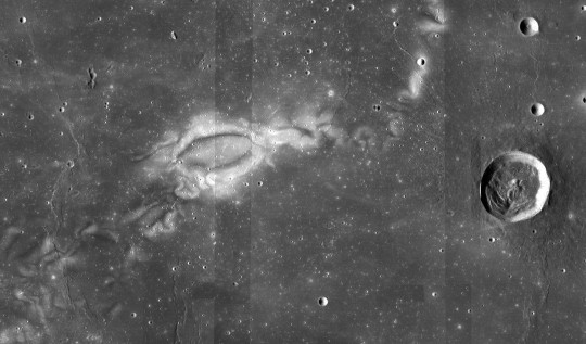
Observations from LRO show mysterious patterns of light and dark that are unique to the Moon. These lunar swirls look painted on, like the Moon got ‘inked.’ Lunar swirls, like these imaged at Reiner Gamma by LRO, are found at more than 100 locations across the lunar surface. Lunar swirls can be tens of miles across and appear in groups or as isolated features.
Researchers think these patterns form in places where there’s still a remnant of the Moon’s magnetic field. There are still many competing theories about how swirls form, but the primary idea is that the local magnetic field deflects the energetic particles in the solar wind, so there’s not as much weathering of the surface. The magnetically shielded areas would then look brighter than everything around them.
4. There were once active volcanoes, that shaped what we see now
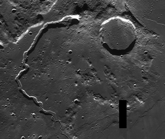
Early astronomers named the large dark spots that we see on the near side of the Moon “maria,” Latin for “seas,” because that’s what they thought they were. We now know that the dark spots are cooled lava, called basalt, formed from ancient volcanic eruptions. The Moon’s volcanoes are no longer active, but their past shapes the Moon that we see today. The Moon doesn’t have large volcanoes like ones in Hawaii, but it does have smaller cones and domes.
Other small features derived from volcanic activity include rivers of dried lava flows, like the ones visible in this image of Vallis Schroteri taken by LRO, and dark areas formed from eruptive volcanoes that spewed fire. For many years, scientists thought the Moon’s volcanic activity died out long ago, but there’s some evidence for relatively “young” volcanism, suggesting that the activity gradually slowed down instead of stopping abruptly.
5. Anyone, anywhere can participate in International Observe the Moon Night.

How to celebrate International Observe the Moon Night
Attend an event – See where events are happening near you by visiting http://observethemoonnight.org
Host an event – Call up your neighbors and friends and head outdoors – no special equipment is needed. Let us know how you celebrated by registering your event!
Don’t let cloudy weather get you down! Observe the Moon in a variety of ways from the comfort of indoors – View stunning lunar vistas through images and videos, or explore the Moon on your own with QuickMap or Moon Trek
Join the worldwide conversation with #ObserveTheMoon on Twitter, Instagram and Facebook
For regular Moon-related facts, updates and science, follow @NASAMoon on Twitter
Make sure to follow us on Tumblr for your regular dose of space: http://nasa.tumblr.com.
2K notes
·
View notes
Text
[DOWNLOAD] Vermont Quickmap by
Download Vermont Quickmap >> https://populardedicatedlibrary.blogspot.com/media15.php?asin=1569148589
Size: 13,160 KB
D0WNL0AD PDF Ebook Textbook Vermont Quickmap by
D0wnl0ad URL >> https://populardedicatedlibrary.blogspot.com/media10.php?asin=1569148589
Last access: 31877 user
Last server checked: 12 Minutes ago!
Vermont Quickmap by [PDF EBOOK EPUB MOBI Kindle]
Vermont Quickmap by pdf d0wnl0ad
Vermont Quickmap by read online
by Vermont Quickmap epub
Vermont Quickmap by pdf d0wnl0ad free
Vermont Quickmap by d0wnl0ad ebook
Vermont Quickmap pdf
Vermont Quickmap by amazon
Vermont Quickmap by free d0wnl0ad pdf
Vermont Quickmap by pdf free
Vermont Quickmap by pdf
Vermont Quickmap by epub d0wnl0ad
Vermont Quickmap by online
by Vermont Quickmap epub d0wnl0ad
Vermont Quickmap by mobi
d0wnl0ad Vermont Quickmap PDF - KINDLE - EPUB - MOBI
Vermont Quickmap d0wnl0ad ebook PDF EPUB, book in english language
[d0wnl0ad] book Vermont Quickmap in format PDF
[PDF] [EPUB] Vermont Quickmap by d0wnl0ad
synopsis of Vermont Quickmap by
review online Vermont Quickmap by
D0wnl0ad & Read Online Vermont Quickmap by >>
https://populardedicatedlibrary.blogspot.com/media13.php?asin=1569148589
0 notes