#richat structure
Photo
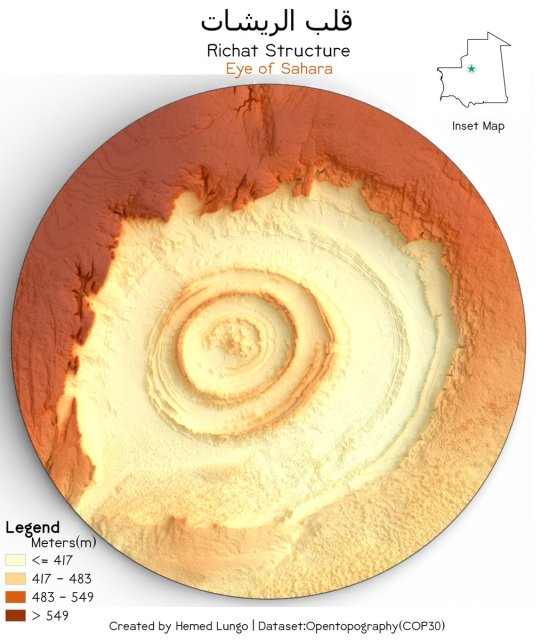
Richat Structure/Eye of Sahara (قلب الريشات) Adrar Plateau, Mauritania 🇲🇷
by @725Hemeed
4K notes
·
View notes
Text
Natural Rocks
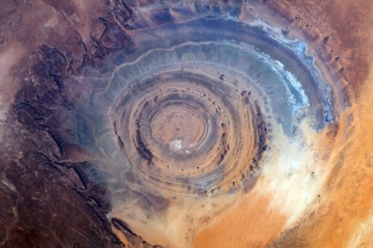
The Eye of the Sahara: A Mystery Older than Humans
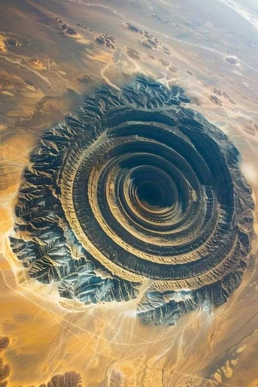
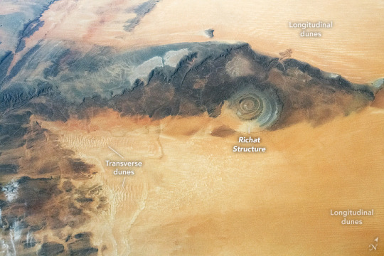
Known as the Richat Structure, the Eye of the Sahara is one of the most interesting and impressive geological formations. It is in the Sahara Desert, stretches for 40 km, and looks like a bullseye. The eye is so huge that it can be seen from space and astronauts use it as a visual landmark. It was first photographed by Gemini Project astronauts in the 1960s.
Totem Made

CASS
Sandra Slead
#natural rocks#photographer#eye of the sahara#landscape#richat structure#sahara desert#nature#totem made#cass
46 notes
·
View notes
Text
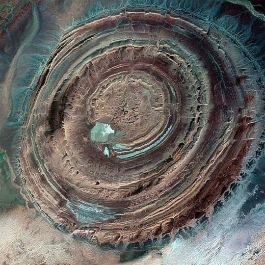
The Eye of the Sahara, also known as the Richat Structure, is a prominent geological wonder in the Adrar Plateau of the Sahara Desert, Mauritania. It's not an impact crater, as once believed, but rather an eroded dome with concentric rings. Read more here:
20 notes
·
View notes
Note
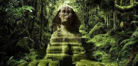
The semsiyat dome and Richard structure are proof of Atlantis. Plato was one of the greatest minds who ever lived and everyone who ever laughed at him about Atlantis is rolling in their graves
You mean the Richat Structure? If you bothered to learn anything about geology you'd be able to see it's a natural rock formation, not a manmade construct. Like yeah it's a wild-looking formation but the ruins of Atlantis it ain't.
6 notes
·
View notes
Text
:::
Remember this?:
4 notes
·
View notes
Video
youtube
“Proof Sahara Desert was BLASTED by Ocean 12,000 Yrs (or later?) Ago”
Flood of Noah? Fascinating.
#flooding#riples#sahara desert#tsunami#ice age#water erosion#natural history#ancient history#earth#sun#cycles#salt#evaporation#mauritania#richat structure#sea water#waves#volcanism#google earth#discoveries
7 notes
·
View notes
Video
youtube
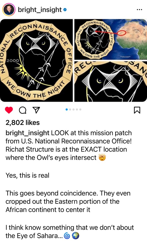
Lost Roman Map has ATLANTIS at Eye of Sahara Africa! (Richat Structure) >
Bright Insight with Jimmy Corsetti | December 17, 2022 | 27:13
1 note
·
View note
Link
2 notes
·
View notes
Text
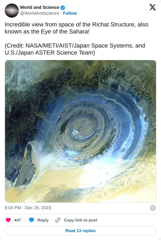
#Eye of the Sahara!#NASA#METI#AIST#Japan Space Systems#U.S#Japan ASTER Science Team#Richat Structure
1 note
·
View note
Text
Richat Structure (Guelb er Richât) - MAURITANIA
69 notes
·
View notes
Video
youtube
#bright insight#atlantis#eye of the sahara#the richat#the richat structure#I'm entirely too invested in this version of things
6 notes
·
View notes
Note
Ok I'll bite
What is your special interest and do you have any fun facts about it?
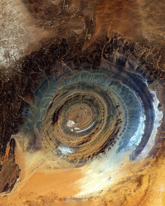
ok there's this thing in the sahara desert called the Richat Structure. It's 30 miles wide, it can only really be seen from space. it just looks like this giant fucking EYE in the middle of the desert. i came across it by accident while just scrolling around on google earth like a decade ago and went HUH???? cause it's so creepy and weird so then I got obsessed.
basically scientists think it's a highly eroded dome and not an impact site or man-made or anything. a bunch of different kinds of rock are exposed in concentric rings. however, it is an archeological site and they've found a bunch of Archeulean tools and artifacts in great condition there (like stone axes and stuff from homo erectus). archeologists think this area was used in tool manufacturing.
im just totally fascinated i think it's cool as hell
19K notes
·
View notes
Text
i learned what are the most mysterious places in the world
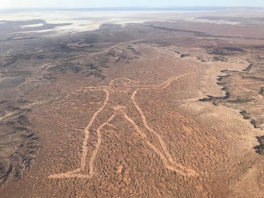
Marree Man – The fact that there is not a single witness to the creation of the Marree Man speaks to the absolute isolation of central South Australia. Somehow in 1998, one person or a group of people were able to create a 2.6-mile long line drawing of an aboriginal hunter, without being seen. In the midst of barren, arid land in South Australia, the Marree Man is the largest geoglyph and work of art in the world. Cut into the harsh landscape with lines over 115 feet wide and one foot deep, the towering Marree Man is easily visible from space. Thirteen years after the Marree Man was discovered during a flyover, little is known about its origin. Although we may never know the true origin of the Marree Man, it is certainly one of most intriguing modern day mysteries.
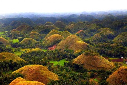
Chocolate Hills – Bohol Island in the Philippines during the dry season, you might notice what looks like thousands of chocolate kisses protruding from the terrain. These mysterious conical mounds are known as the Chocolate Hills. There are approximately 1,268 individual hills, their heights ranging from 100 to 160 feet, though the highest is almost 400 feet high. The hills, which are almost all symmetrical, consist of grass-covered limestone and turn brown during the dry season. Despite the abundance of hills, it is unclear how they were formed. There are multiple geological explanations ranging from oceanic volcano activity to limestone weathering. Numerous legends and tales also exist to explain the Chocolate Hills.
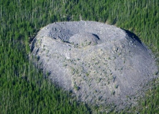
Giants Nest – In 1949 a geologist named Vadim Kolpakov discovered a large mound of limestone in the north of the Irkutsk region in southeastern Siberia. The cone is curiously shaped with a crater at the top and a small mound in the center. The mound is about 40 meters high and 100 meters across at the base. The smaller mound at the top is about 12 meters high. The crater was named Patomskiy, after a nearby river, but local residents call it “the Fiery Eagle’s Nest”. Since the discovery of the crater, there have been many theories as to what could have created it. For a long time it was believed to be a meteorite impact structure. Some linked it to the Tunguska meteorite, whose remains have never been discovered. But the crater does not resemble any other known meteorite site. Even now, the origin of the crater is not discovered.
Richat Structure – In the midst of vast, vacant Sahara desert, just outside of Ouadane, Mauritania, lies a 30-mile wide geological oddity known the Richat Structure, sometimes called the “Eye of Africa.” From space, this natural curiosity forms a distinct and unmistakable bull’s-eye that once served as a geographical landmark for early astronauts as they passed over the Sahara. Once thought to be an impact crater due to its circularity, the unusual formation is now widely believed to have been caused by the erosion of a geological dome formed by pressure from a bulb of molten magma below.
Plain of Jars – The Plain of Jars is a collection of large stone jars interspersed throughout the Xieng Khouang plain in the Lao Highlands. The stone structures are mostly made of sedimentary rock and, ranging from 3 to 10 feet in height, each can weigh up to 14 tons. To date, the origin of the jars is unknown, though archaeologists believe that they were originally used between 1,500 and 2,000 years ago. Many researchers have theorized that the jars may have once served as funerals urns or food storage. As local Laotian legend would have it, the jars were created by Khun Cheung, an ancient king of giants who lived in the highlands. It is said that Cheung, after fighting a long and victorious battle, created the jars in order to brew huge amounts of celebratory lao lao rice wine.

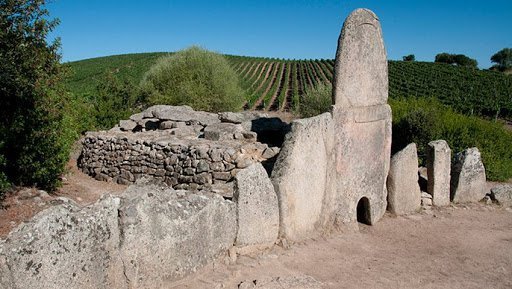
Giant’s Grave of Coddu Vecchiu – Giant’s or Tomba Dei giganti, are megalithic gallery graves that were used as public tombs during the Bronze Age. The massive gravestones were built by the Nuragic civilization, which existed in Sardinia from the 2nd millennium BCE. to the 2nd century CE. Despite the imaginative name, the sites were not the burial site of any giant; they were giant community burial chambers. Though we know the tombs had a funerary purpose, more questions remain. Little is known about the rituals or traditional beliefs that motivated their construction. Were they mass graves? Were they built to facilitate the journey into the afterlife? Since their existence has yet to be justified by scientific research, they have been credited to the supernatural, which has only increased their mystery. Legend also claims that yes, indeed, these were the tombs of powerful giants.
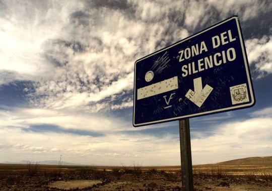
Zone of Silence – Pilot Francisco Sarabia was flying over a patch of desert land in Mexico when his instruments started to act increasingly odd. The man had to make an emergency landing in the middle of nowhere. Little did he know that this "nowhere" would be later dubbed "The Zone of Silence.” Weird radio silence isn't the only oddity of the creepy Zone. Like, what’s that weird trio that locals keep meeting in the Zone? They’re two men and a woman. Every time people see them, they’re wearing bizarre clothing that isn't suitable for a journey in the desert whatsoever. On top of all that, the Zone of Silence is known as a 50 km patch of deserted land where meteorites come crashing down on an eerily regular basis. On July 11, 1970, the US launched an ATHENA rocket from the Air Force base in Green River, Utah. The rocket was supposed to land somewhere in the area of White Sands in New Mexico. Instead, it went off course and, as if being pulled by some external force, crashed right in the heart of the Zone of Silence.
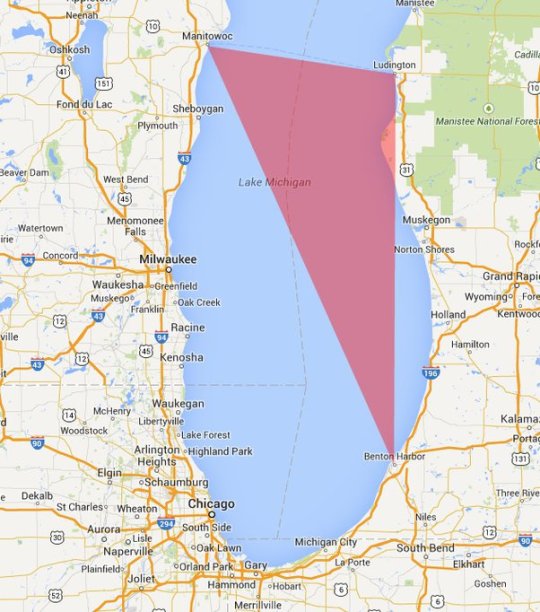
Michigan Triangle – Stretching from Ludington to Benton Harbor, Michigan and to Manitowoc, Wisconsin, the Lake Michigan Triangle has inspired numerous accounts of activity that are difficult to explain by rational thought. The mystery began in 1891, when a schooner named the Thomas Hume set off across the Lake to pick up lumber. Almost overnight in a torrent of wind, the Thomas Hume disappeared along with its crew of seven sailors. The wooden boat was never found. After the turn of the century, strange events happened at steady intervals. Of the more mysterious is the case of the Rosa Belle. In 1921 eleven people inside the ship, who were all members of the Benton Harbor House of David, disappeared and their ship was found overturned and floating in Lake Michigan. While it appeared that the ship had been damaged in a collision, no other ship had reported an accident and no other remains had been found.
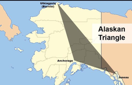
Alaska Triangle – The Alaska Triangle is a place in the untouched wilderness where mystery lingers and people go missing at a very high rate. The area began attracting public attention in October 1972, when a small, private plane carrying U.S. House Majority Leader Hale Boggs, Alaska Congressman Nick Begich seemingly vanished into thin air. For more than a month, 50 civilian planes and 40 military aircraft plus dozens of boats, covered a search area of 32,000 square miles, but no trace of the plane, the men, wreckage or debris were ever found. Afterward, more planes went down, hikers went missing, and Alaskan residents and tourists seemed to vanish into thin air. In fact, since 1988, more than 16,000 people have disappeared in the Alaska Triangle, with a missing person rate at more than twice the national average. These disappearances are blamed on everything from severe weather to aliens, to swirling energy vortexes, to an evil shape-shifting demon of Tlingit Indian lore called Kushtaka, with no scientific explanation to the disappearances till today.
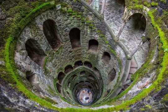
The Initiation Well – The Initiation well is 88 feet deep well located on the land of Quinta da Regaleira. Actually, it was used for ceremonial purposes. There is another small well near this well. Both these wells are connected by tunnels. The larger well contains a 27-meter spiral staircase with several small landings and the smaller well contains straight stairs that connect a series of ring-shaped floors to one another. The smaller well is also called the 'Unfinished Well'. The depth of this larger well is equal to the four-storey building, which becomes narrower on going closer to the ground. It is believed that there is some kind of light comes out from the well inside the ground and comes outwards. Surprisingly, there is no system of light inside this well, then where from this light comes, it is the secret. Anyone who comes to visit here, always raises the question of where the light comes from inside the well? Till today this secret is unsolved.
(Image Source : Google)
Thanks for Reading.
691 notes
·
View notes
Text
youtube
.
.
.
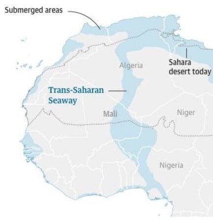
#trans saharan seaway#cataclysm#richat structure#shit just keeps getting older#amnesia#eye of the Sahara#antiquitech#atlantis
5 notes
·
View notes
Text
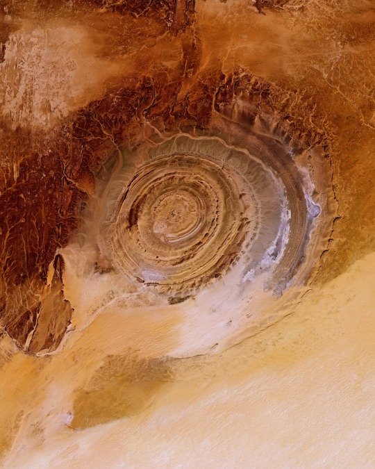
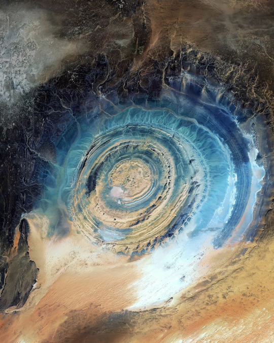
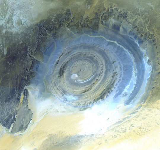
The Richat Structure, also known as the “Eye of the Sahara,” is a prominent circular feature in the Sahara Desert of west-central Mauritania. Measuring 30 miles (50 km) in diameter, the structure was originally thought to have been formed by the impact of an asteroid; however, it is now known to be an eroded structural dome of layered sedimentary rocks.
21.124000°, -11.402000°
Source imagery: Planet
713 notes
·
View notes
Text
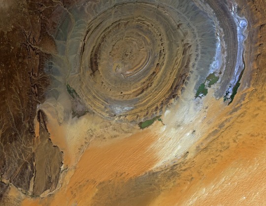
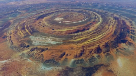
The Richat Structure in the Saharan Desert of Mauritania.
An eroded geologic dome.
22 notes
·
View notes
Last Seen Blogs

classic-property-management
Classic Property Management

wishuponawish
Certified Nonfunctional Potato

corevocation-observatory
Corevocation's Constellations

supersoniii
🐾🎮🐶 prettiest pup in da world !🐶🍥🐾

castingdirect
Casting Direct