#river Forth edinburgh
Text
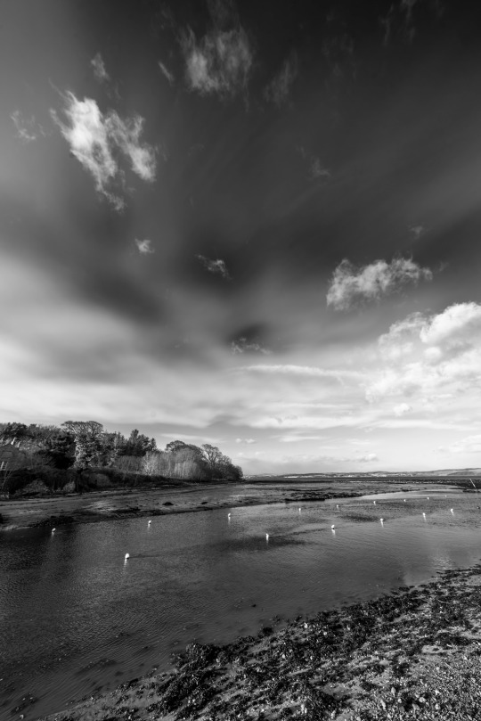
River Almond at Cramond, Edinburgh
#photographers on tumblr#original photographers#luxlit#imiging#black and white#edinburgh#black and white photography#original photography#landscape photography#River Almond#Cramond#coastline#Firth of Forth
67 notes
·
View notes
Text
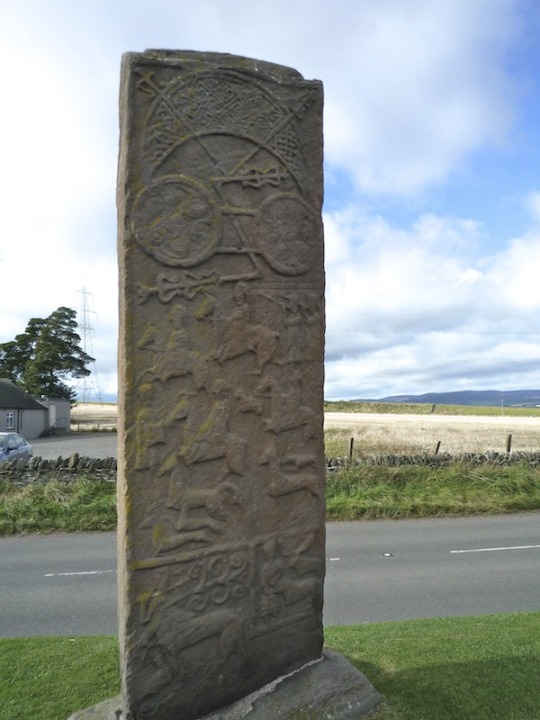

On 20th May 685 The Picts won a decisive Battle , in present-day Angus, known as The Battle of Dun Nechtain or Battle of Nechtansmere.
A wee bit longer post than I normally give you, but it is a great story, the first part tells us how a battle against The Angles helped shape the country we now know as Scotland, the second is a tale from the twentieth century, both stories are connected, read on and enjoy.........
Known as 'Picti' by the Romans, meaning 'Painted Ones' in Latin, these northern tribes constituted the largest kingdom in Dark Age Scotland. They repelled the conquests of both Romans and Angles, creating a true north-south divide on the British Isles, only to disappear from history by the end of the first millennium - swallowed whole by the history of another group, the Gaels. Together they created the Kingdom of Alba.
The Picts took part in one of the most decisive battles in Scottish history - the Battle of Dun Nechtain (Dunnichen). If the Picts had lost, Scotland might never have existed. For the Angles of Northumbria it was simply a disaster - ending their domination of Scotland.
The Battle of Dun Nechtain was fought on this day in 685 AD and is one of the best recorded events in Dark Age Scotland.
The Kingdom of the Angles under King Oswui had rapidly expanded north, moving their frontier from the River Forth to the River Tay. Since 653 AD many of the major groups of people in Scotland - Britons, Gaels and much of Pictland - had been subject to the overlordship of King Oswui. In 672 AD, after the death of Oswui, the Picts rose against their overlords, expelling Drust, their Northumbrian puppet king.
The new King of Northumbria, Ecgfrith, wasted no time in wreaking revenge on the Picts. The Picts were massacred at a battle near the town of Grangemouth, where the rivers Carron and Avon meet. According to Northumbrian sources, so many Picts died they could walk dry-shod across both rivers. By 681 AD Ecgfrith had founded a bishopric at Abercorn on the southern shore of the Forth - a symbol of Northumbria's secure grip over the Picts.
The defeated Picts took Bridei, son of Bili, as the king of a much depleted Pictland. King Bridei was actually the cousin of his mortal enemy, King Ecgfrith of the Angles, but, in true Dark Age fashion, this didn't diminish their mutual desire to destroy each other. An almighty battle was on the cards.
The Chronicle of Holyrood gives us an account of the battle: "In the year 685 King Ecgfrith rashly led an army to waste the province of the Picts, although many of his friends opposed it...and through the enemy's feigning flight he was led into the defiles of inaccessible mountains, and annihilated, with great part of his forces he had brought with him." However, we need to keep in mind this account was written hundreds of years after the event.
The Angles were advancing up Strathmore, probably aiming for the Pictish fortress of Dunnottar, when they fell into Bridei's trap. Sighting a Pictish warband, the Angles set off in pursuit, then, as they came over the cleft in Dunnichen Hill, they found themselves confronted by the main body of the Pictish army. Caught between the Picts and the loch below the hill, the Angles bravely faced their doom.
The politcal map was altered. The Picts, Gaels and many Britons were freed from Northumbrian overlordship. Gaelic poets as far away as Ireland celebrated the battle's outcome. The Pictish frontier returned to the River Forth near Edinburgh and the Bishop of Abercorn fled, never to return. The Angles never fully recovered as major force in Scotland.
It is no coincidence that the Picts mysterious disappearance occurs at the same time as the creation of the kingdom of Alba. For many years Gaelic influence in Pictland had been on the rise. The Gaelic religion of Christianity had spread throughout Pictish lands and with it many Gaelic traditions. Furthermore, through a mixture of conquest and inter-marriage Gaelic or Gaelicised royalty had succeeded to the Pictish throne (a notable example of this being Kenneth MacAlpin).
Finally in 878 AD the Pictish king, Áed, was murdered and replaced by a Gael - Giric. Giric accelerated the Gaelic takeover of Pictish politics during his reign making the Gaelic language and traditions commonplace. Even after Giric was finally deposed in 889 AD future Pictish kings such as Donald and Constantine embraced Gaelic culture. By 900 AD Pictland ceased to exist. The reign of Donald is listed in the Chronicle of the Kings of Alba as a king of Alba. Pictland and Dál Riata had gone and in their place Alba - a Gaelic word for Scotland - was created. In this simple listing in an obscure book Scotland has its origins.
Fast forward over 12 hundred years to the 2nd January 1950, and a woman called Miss E.F. Smith, described as a spinster, was driving home from a party in Brechin at about 2am. Her car had skidded into a ditch 2 miles outside the area due to the treacherous road conditions. She still had another 8 miles to go so she continued her journey on foot. She felt oddly nervous as she walked along the minor road west of the A932, then she saw a number of strange lights in the distance near Dunnichen Hill. Turning south towards the village, she noticed figure in the field to her right, part of Drummietermont Farm. Each figure carried a flaming red torch in its left hand and they seemed to be searching the ground for something.
Miss Smith then saw shapes on the ground exactly like dead bodies. The figure nearest to her stooped down and examined several of these ‘corpses’, turning them over and back again, as if looking for recognisable faces. This scene lasted for around ten minutes, with Miss Smith’s dog barking throughout. Eventually she simply walked away. She only realised that the whole event was peculiar when she woke up next day and thought about it. Later she gave details of the experience to the Society for Psychical Research. She reported that the searchers wore garb like body stockings, along with tunics and flattened oval helmets. They appeared to be moving around the edge of the vanished mere, the shape of which was later traced by archaeological investigation.
Although this post battle manifestation has not been repeated. some motorists passing through Dunnichen on misty nights have caught sight of fleeting human forms which vanish before their cars hit them.
There is some skepticism as to how real Miss Smith’s sighting was. She was travelling very late at night and had already walked a number of miles, not to mention suffering a trauma from skidding her car into a ditch. The vision could have been brought about as a result of exhaustion and the effects of the cold. However, the fact that it occurred at the exact site of the Battle of Nechtansmere seems to be too much of a coincidence and it is unlikely that the woman’s dog would react to something that occurred only in his owner’s mind.
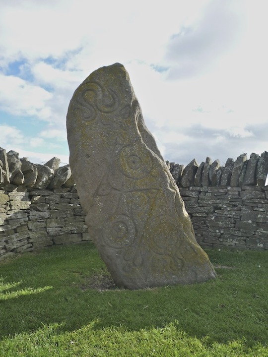
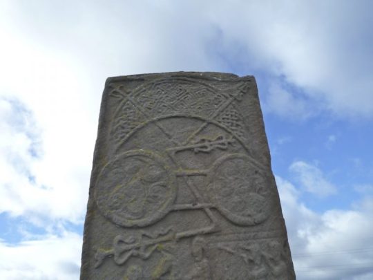
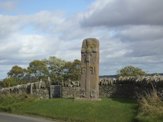
The pictures are of Pictish stones from around Aberlemno that perhaps tell the story of the battle.
84 notes
·
View notes
Text
Outlander’s last read-through was organised with an extravaganza, revealing the final script of season 8 during the last run-through It’s all a big Farewell to the series at the Barnbougle Castle on the shore of the River Forth, controlling access from the North Sea into the heart of Scotland.
This 13th-century Castle is one of Scotland’s hidden treasures. It commands spectacular views over the Firth of Forth and is surrounded by the secluded, wooded parklands of Dalmeny Estate.

Barnbougle Castle is a historic tower house on the southern shore of the Firth of Forth, between Cramond and Queensferry, and within the parish of Dalmeny. It lies within the Earl of Rosebery's estate, just north-west of Dalmeny House. Barnbougle is only minutes from Dalmeny House, the majestic family home of the 7th Earl of Rosebery. It is well located as a venue - secluded, yet close to Edinburgh and easily accessed.
Barnbougle offers the most memorable of event spaces - the very best that Scotland has to offer. The sixty foot long Banqueting Hall has a Minstrel’s Gallery and breathtaking views.


The grand Scottish Library has thousands of books and open access onto the sea-facing terraces and private beaches.

@sophie.skelton & Barnbougle Castle


The Castle caters for up to 140 guests seated or 200 standing and up to 450 in marquees. This makes the venue versatile - whether for large-scale entertaining or more intimate gatherings with family and friends.
📹@caitlinoryan

Posted 12th August 2024

SH-IG
21 notes
·
View notes
Text
Scottish Borders
Today dad and I boarded a bus for a tour if the Scottish Borders, the southernmost part of Scotland, near the border with England. We met the bus in a different part of Edinburgh and it had a lovely view of the river Forth .

Our first stop was in the Scottish town of Jedburgh where we saw a ruin of a medieval abbey and a house that Mary, Queen of Scots stayed in around 1600.


Later we got off the bus and walked the 20 steps from Scotland to England.


Then we stopped at Steel Rigg to view up close a portion of Hadrian's wall. it's the wall that the Roman Emperor built all the way across the narrowest part of Scotland. He decided not to make the effort to conquer the Scots people. The rocks for the wall were cut to a uniform size and the wall was 16 feet tall and 10 feet wide. You could walk and drive a cart along the road on top. Today the wall is 3 to 6 feet tall above ground . Every so often there is a watchtower and occasionally a fort. Here's a bunch of pictures that don't do this justice. Look for the wall way behind us running to the top of a very steep hill.


2 notes
·
View notes
Text

Princess Royal Celebrates One Of World’s Oldest Yacht Clubs
Forces News | Published 5 June 2018
The Princess Royal has visited HMS Archer to celebrate one of the world’s oldest yacht clubs 150th anniversary.
The Royal Forth Yacht Club in Edinburgh was formed by 26 local men and has operated from the Granton Harbour for generations - giving members the chance to try sailing on the Forth estuary.
The Club's Patron - HRH The Princess Royal - boarded Royal Navy Patrol Boat HMS Archer to take the salute from yachts participating in the Club’s Anniversary Parade of Sail.


Princess Royal also unveiled a plaque marking the club's anniversary.
Charles Morton, Commodore of the Royal Forth Yacht Club, said:
“It is a particular privilege to have been elected Commodore in this special year. We will be holding an Anniversary Regatta later in June with an Anniversary Cruise in Company setting off North at the beginning of July.
“We are honoured to have HRH The Princess Royal as our Patron, particularly as she is a sailor herself, and we are very grateful for her support.”

The Club’s Royal connection started in 1883 when HRH Queen Victoria was “graciously pleased to command that henceforth the club would be known as the Royal Forth Yacht Club”.
Captain Chris Smith, Naval Regional Commander Scotland and Northern Ireland, said:
“The Royal Navy were delighted to help support the Royal Forth Yacht Club’s 150th anniversary.
“Much like the Navy, The Royal Forth Yacht Club is an organisation with a long and proud heritage on the River Forth. Its role in developing an understanding of the sea, whether that be for recreational or commercial use, is important to all of us living in this island nation.
“The crew of HMS Archer were honoured to host Her Royal Highness and to be part of the event, especially since the ship is Edinburgh-based and is the training vessel for Edinburgh University Royal Navy Unit.”
HRH Prince Philip is also an honoury member of the club.
27 notes
·
View notes
Text
Day Twenty


Another day and another set of miles down!
Allowed myself a small lie in because why not, so after breaking camp and a good cuppa, we're back on the road by Longniddry for just before 9am.
The route from here is downhill all the way to the sea by Port Seton, where we get a nice view of the Fife coast across the bay, and have a nice ride along the coast including a stop off for water and some much needed fresh fruit!
Past Prestonpans and into Musselburgh the pathing and aignposts do get a bit of a mess, and ended up riding around the racecourse for a time as golf balls flew overhead, but some judicious map checking and rerouting took us past the River Esk and along into Edinburgh.
Once back to the main cycle route there was some lovely off-traffic riding past Holyrood Park and a long fun tunnel, before heading into Edinburgh cuty centre.
I'd been advised by some other riders that the route through was beat avoided as the signposting was poor and cobbled roads aboundes, but I suspect they had been on an alternate route as I found the signage pretty decent and had no real difficulty riding through, and stopping for an early lunch in The Meadows.
At this point, the run of sunny days finally came to an end and the rain finally caught up. Thankfully I'd been keeping an eye on the forecast and was already sheltered under a nice tree when the rain set in, and as I'm well used to riding in the UK it was time to break out the waterproofs.
They were sorely needed, as the heavens truly opened and a torrential downpour began for a couple of hours. So whilst I did enjoy a very wet ride past some of Edinburgh's beautiful monuments and highlights, I'm afraid there is a bit of a lack of pictures of them!
After heading down Princes Street past the castle, rather than keep diverting onto the side paths I decided on a straight run down the busy Queensferry road, which had partially turned into a river and featured being sprayed by passing motorists with waves of water over head height at times.
Once a few miles along and across the River Almond the bike path picks up proper again and I could finally get out of the traffic and continue on to arrive at the Forth Bridge Visitor Centre, when the rain finally eased off.
Had a good break here for a nice hot coffee and chat with some other visitors, and checking the waterproofs it looked like they jad succeeded in their job - whilst I was a little soggy underneath, it appeared predominantly to just be sweat.
Onwards! Across the impressive Forth Road Bridge! I had some nice nostalgia crossing here as the last time I rode over it was when riding Lands End to John O'Groates. At that time the newer Queensferry Crossing Bridge was still under construction, and the road bridge was bouncing quite significantly from all the heavy traffic. With this now routed across the new bridge, the journey over this time was far calmer and ideal for enjoying the ride.
Heading down the other side, it's a right turn past the junctions into Iverkeithling on route 76, and almost immediately there's some gorgeous views around the waterside past Saint Davids and Dalgety Bay. The path carries on hugging the Fife coast for a good while granting more beautiful views of the opposite shore.
The clouds had eased off at this point and the sun had returned anew, which swiftly dried off the soggier bits and returned us to a lovely afternoon's weather.
There were some more interesting points of course, including a diversion to avoid a larger road along an alternative path that turned out to be very thoroughly overgrown with nettles and thorns. After a little way I wondered if I'd made a significant mistake, especially as it was too narrow to turn around, but the path finally opened up to a beautiful ride right next to the water, with a forested cliff to the left that even featured a few waterfalls. I count that as worth a few stings!
Continuing along the shore past Burntisland, there was a very conveniently placed bench with some shelter from the wind to allow me to cook up some dinner and savour more of the views across the water.
I cut out an inland division of the trail by Kinghorn to keep heading round the coast to Kirkcaldy, before realising it was getting a little late and I should find a spot to sleep. I had underestimated the oength of the urban stretch here, but fortunately not having to be up the crack of dawn means I was still able to cruise out the other side of town and find some nice forested areas to set up for the night.
Not too bad a day's work all told! Whilst the NCN routes cut north at Kirkcaldy and miss the rest of the coast up to St Andrews, there are still plenty of local paths in place, so hopefully tomorrow I can continue along and not be stuck with roo much in-traffic riding as we work back around to link up eith the main route again.
G'night!
2 notes
·
View notes
Photo


Tagus River, Belém
The 25 de Abril Bridge (Portuguese: Ponte 25 de Abril, 25th of April Bridge) is a suspension bridge connecting the city of Lisbon, capital of Portugal, to the municipality of Almada on the left (south) bank of the Tagus river. It has a total length of 2,277 metres (7,470 ft), making it the 46th longest suspension bridge in the world.
From its inauguration on 6 August 1966 up to 1974, the bridge was named Salazar Bridge (Ponte Salazar), after Portuguese Prime Minister Ant��nio de Oliveira Salazar, who ordered its construction. After the Carnation Revolution, which overthrew the remnants of Salazar's regime, the bridge was renamed for April 25, the date of the revolution. It is also commonly called the Tagus River Bridge (in Portuguese: Ponte sobre o Tejo = "bridge over the Tagus").
Later changes had to be made due to the rapid increase in population. In the 1990s, a fifth car lane was added, and in 1999, a lower deck, used as a railway track, which was planned since the beginning, was finally built. Today, the upper deck carries six car lanes while the lower deck carries a double track railway, electrified at 25 kV AC.
The 25 de Abril Bridge is based in part on two San Francisco Bay Area bridges. Its paint is the same International Orange color as the famous Golden Gate Bridge, and the design is similar as well for the San Francisco–Oakland Bay Bridge. Both the Bay Bridge and the 25 de Abril Bridge were built by the same company. The American Society of Civil Engineers says: "Like its sister bridge, the SFOBB in San Francisco, the Tagus River Bridge is located in an area with a long history of earthquakes" and seismic data had to be taken into account in its construction. Another sister bridge is the Forth Road Bridge in Edinburgh.
Upon completion, the bridge had the longest suspended span and the longest main span in Continental Europe, the world's longest continuous truss, and the world's deepest bridge foundation. It was the fifth-largest suspension bridge in the world, and the largest outside the US. Today it is the 43rd largest suspension bridge in the world.
Source: Wikipedia
#Tagus River#River Tajo#River Tejo#Padrão dos Descobrimentos#Belém#Lisboa#Lisbon#25 de Abril Bridge#engineering#riverwalk#white colonialism#architecture#public art#travel#vacation#summer 2021#original photography#tourist attraction#landmark#Portugal#Southern Europe#cityscape#boat#ship
2 notes
·
View notes
Text
under the gorse - interior location
Finding a Location
As a co-producer on this film, one of my agreed responsibilities was to search for an interior location, whilst Sam and Jack focused on exteriors.
My family live in a small village called North Queensferry and I knew instantly that this would be an ideal setting for the interior section of the film. I asked family friends who live around the village if they would be open to allowing us to shoot in their homes and got a positive response overall with several of them more than happy to help. There was one in particular that stood out due to its unique location and interiors and has also been seen in several BBC dramas beforehand. It is positioned directly underneath the Forth Road Bridge and has an amazing view over the River Forth.
We had offered payment as we would be using the whole house and facilities for several days, however, they were very kind in refusing the payment which we very much appreciated.
The location was ideal as the owners were not in the house for the duration of our shoot which gave us the freedom to use it as we wished. I was very cautious about certain rooms being used as there were a lot of precious items belonging to the family, but thankfully the production design team were very respectful of this and helped me to keep track of everything that we moved so it could go back to the appropriate place.
Shoot Days
The day prior to the shoot, I met with the production designers, Cara and Antony, and dressed the main rooms with the numerous props they had gathered. The rooms looked great and it was clear that they both had put a lot of thought into how they could represent each character with the production design.
Unfortunately the living room, despite being dressed and lit, was not used due to scheduling issues. However, the shots in the final film that feature the house are visually stunning. Aside from the house, we also shot some scenes in the surrounding area of the village.
Whilst the rest of the crew departed for Glencoe, I took down all production design and made sure the house was back to its original state. I would have appreciated more help with this take down, but it was made difficult due to time restraints and the fact that the remaining crew on the final day of the interior shoot needed to collect a prop (the bathtub) very last minute, leaving me to clear the set around 10pm.
In terms of the actual shoot, it was chaotic and we unfortunately did not get all of the shots that we needed. I had stated clearly prior to my departure to Poland for my main shoot that I would not be able to assist with scheduling. When I came back I was disappointed to find that there was not a realistic schedule in place. This meant that there was a lot of tension between some of the crew, especially the 1st AD and director. I felt it was crucial to keep this tension away from the girls and their chaperone as it would not be a good idea to start the shoot with the crew presenting themselves as dysfunctional, considering they had committed to what ended up being a 7 day shoot. We were able to pick-up the shots we needed in Edinburgh in a different location that Sam secured, however, I feel disappointed that such a strong location was partly wasted.
0 notes
Text
#MusicMonday Review - April 2023
#MusicMonday is the hashtag I've been using for quite a while to share music recommendations from up-and-coming artists. Always fresh, and always different, trying to look for trends before they become one. You can check March's review for more music.
Welcome to our moody edition, where this month's music may transport you to a different state, temper, place, or era, all with a word from the artists themselves. 🎧
asia – Twenty twenty
I never thought
that you would want to fall for me
til you did
Now I don't know where you are
Doesn't matter now
So I don't know where I am
Sometimes you only need a guitar, and inspiration, to set a mood like no other, like this Sad Indie track, coming from Brussels, Belgium:
"I wrote it during Covid so it was largely inspired by the feeling of being stranded hahaha"
The Lonely Together – City Lights
Some men will never find love
They're chasing all the wrong kind of city girls
And it's true that there are many
But for me, there was only ever one
I've never been so worried
and I've never felt so scared
in the knowledge that I cannot be there
From Edinburgh, Scotland, another dreamy mood piece, where the city air feels warm, floodlit by the sun, hanging over the absence of that special someone:
"I wrote it while apart from someone I cared about… the feeling of distance - different cities/views/surroundings and the emotions that stirred up. It’s a real love song."
Delta – En Mi Lugar
Siete copas tras la barra son algunas de las farras
Que hace tiempo no me pego
Solo puedo dar las gracias peinarme las cuatro canas
Por lo bien que lo hemos hecho
En mi lugar, mirar atrás
Sentir que todo pasa y nada está de más
Un chaval, que no da más
Al fin entiende que todo llega al final
Moving now to Barcelona, this Spanish Pop track offers a nostalgic mood in which time often puts us in our place:
"Well that’s an easy one! Since En mi Lugar is probably the first song with a common ground to share between all our band mates. A bittersweet feeling we all share when we take a look back into our lives only to realize how wonderful our past experiences have been, and at the same time facing the truth of knowing that most of those experiences are never to be repeated again."
Storm the Palace – Some of the Beasts and Birds We Saw
You and I found this
In a moment, a pause for thought
A faulty rhyme of two straight lines
One pushes back, the other forth
One day you will grow into yourself
And then you will blossom for all to see
And no one will take your for any less
Than you were meant to be
We go back to Edinburgh for a taste of Pagan Pop, complete with its own medieval mood that can make a new adventure from your daily dog walk:
"It started with a bit of graffiti on the river path near my house, which read "some of the beasts and birds we saw". WillaDavie took this and turned it into lyrics, which I then turned into the song.
I think the song is about the time she and I spent together throughout lockdown, going for walks, drinking in graveyards, talking about life and art and all things in between."
Pan Arcadia – Deja Vu
We’ve been left to instinct
Left an imprint on my brain
Often it's been different
But it didn’t feel that way yesterday
I remember on the lawn
How you used to sing along
And I know you remember too
You say you still get satisfaction
From that fast and easy action
I know I still get it too
For our last mood of the month, let's go to Williamsburg, Brooklyn for an Indie Rock track about that good ‘ole deja vu that gets us through the night in the city:
"The song was inspired by being in quarantine and thinking about summer days in New York City."
Listen to them and much more on the complete Playlist:
0 notes
Text
Scotland Hydro Nation Chair to lead water quality project to protect river ecosystems
New research led by the University of Stirling is to explore how pollution and climate change are impacting freshwater ecosystems for the first time. Prof Andrew Tyler provides a summary of the project and its ambitions.

The Natural Environment Research Council (NERC) launched a call in April 2022 for projects that would address a significant gap in our understanding of how pollutants enter, transform and interact within rivers, and with the ecosystems that rivers support. The Understanding changes in quality of UK freshwaters call is part of a £8.4 million programme of research funded by NERC, with Department for Environment, Food and Rural Affairs (Defra) that will support innovative collaborations including those with intervention-focused organisations and practitioners, creating a community of researchers and funding projects that span the three thematic areas of the programme.

Prof Andrew Tyler, Scotland Hydro Nation Chair, leads one of the five projects funded. Prof Tyler's project, MOT4Rivers, sees a consortium led by University of Stirling pulling on expertise from the James Hutton Institute, UK Centre for Ecology and Hydrology, The School of Engineering at the University of Edinburgh and University of Glasgow, along with valuable project partners to investigate how pollutants interact with rivers and ecosystems, and devise a system to monitor and measure pollution.
For centuries, human activities have impacted our rivers by shifting the sources and combinations of physical, biological and chemical drivers and pressures. However, our understanding of their impact on ecosystems has been limited by viewing each in isolation and not considering their combined effects.
Our freshwater species are being challenged by a bewildering combination of pollutant cocktails (mixtures) whose effects are poorly understood. At the same time, climate-change driven shifts in water quantity (more frequent floods, longer periods of low flow) and warming waters are expected not only to be influencing the function, physiology, abundance and biological timings of freshwater ecological communities directly, but also the delivery and potential toxicity of these cocktails respectively. It is not simply the water pathway that we need to consider, but also the re-mobilisation of contaminants and the changing patterns of exposure that potentially magnify the effects on biota (i.e. organism sensitivity). Increasing urbanisation and changes in rainfall intensity and its seasonality, different catchment processes all have the potential to increase inputs of these emerging contaminants to the environment.
Our research, through the £2million MOT4Rivers project, will address these gaps by embracing the digital revolution through innovative technologies and transformative data analytics to deliver a step change in our knowledge and understanding. Our approach has three strands. The first will turn a spotlight on the Almond catchment in West Lothian, a sub catchment of the Firth of Forth catchment. The Almond is a typical catchment encompassing rural to urban land uses through rigorous investigations that will deliver high temporal resolution data. This investigation will provide new understanding of acute/event-based impacts on freshwater ecosystems.

The River Almond in West Lothian; Image credit: Scottish Water
Secondly, we will use national scale datasets and cutting edge data analytics tools to investigate the impacts of longer-term exposure to pollutant cocktails across the UK on water quality and ecosystem health. These findings will provide new understanding of chronic/long term impacts on freshwater ecosystems.
Thirdly, we will integrate our new evidence base and understanding into a risk-based probabilistic model. The model will allow the exploration of the relationships between environmental change, declining river quality, multiple pollutants and ecosystem impacts. Our research will develop the evidence base to understand changing pollutant sources, delivery pathways and the environmental tolerances and boundaries within which organisms can thrive and flourish (i.e. the ecosystem safe space).
Together, MOT4Rivers will inform priorities for policy, regulation and investment to design cost effective programmes of measures to promote and enhance sustainable freshwater ecosystems under a changing climate.
For more information on the project please see the University of Stirling press release, follow #HydroNationChair on Twitter and come back soon for a project webpage under R & I Infrastructure.
#You can keep up to date with the other four projects and overall programme via the Freshwater Quality Programme twitter and #UKFreshwaterQualityProgramme which is being championed by the University of Leeds.
#research#innovation#hydronationchair#team#industry#funding#rivers#transformation#NERC#DEFRA#Pollution#RiverAlmond
0 notes
Text
leaving
copyright c e ayr
leavingit’s still numpty o’clockas the plane clambers awkwardlyout of Edinburghthe sun creeps from the Forthwhere the river meets the North Seashowing the three great bridgesin silhouetteI smileknowing that this afternoonI’ll be home againin my own corner of Paradiseon the Côte d’Azurand my mind driftsback over the past weekthe highlight as alwayswas the day spent with my…
View On WordPress
#ayr#Broxburn#clyde#kelvingrove#kindness of friends#poem#poetry#river Forth edinburgh#riverside museum Glasgow#robert burns#scotland#Union Canal
1 note
·
View note
Photo


Deux pilotes de la Luftwaffe, abattus le 16 octobre 1939 au-dessus du fleuve Forth, August Schleicher et Kurt Seydel, sont enterrés avec les honneurs militaires de la Royal Air Force, la croix gammée drapant leurs cercueils. La procession a eu lieu depuis l'église Saint Philip jusqu'au cimetière Portobello à Milton Road East à Edimbourg - Ecosse - 21 octobre 1939
©Colorisation par Royston Colour
#WWII#enterrement#funeral#Luftwaffe#royal air force#RAF#River Forth#Edimbourg#edinburgh#Ecosse#scotland#Grande-Bretagne#great britain#21/10/1939#10/1939#1939
9 notes
·
View notes
Text


June 10th 1768 saw construction start on the Forth and Clyde canal, it was to take 22 years to complete.
The building of a canal across Scotland was first discussed during the reign of Charles II. It was not until the mid-1700s that the building of the Forth and Clyde Canal or “The Great Canal” as it was referred to then, became an actual possibility with funding being raised to carry out the work. The canal was to be built across the Central Belt of Scotland from east to west. The first spadeful was dug out in June 10th 1768 and the construction continued for 22 years including a 7 year period when no work was carried out due to lack of funds. It was the Canal Company’s policy to try to recruit locally to provide employment in the areas the canal crossed.
The work was hard and was manual labour with the use of picks and shovels to dig out heavy wet earth. Wages were about 10d (£0.04p) per day and the workers were a tough lot. Discipline was often hard to maintain and drink was cheap and plentiful causing various problems. Theft of tools and other equipment was common and often the workers were seasonal due to also working in the agricultural land surrounding the canal works. None the less the work was done and the canal was dug. Water was first let into the canal in 1773 when it was filled as far as Kirkintilloch, which increased this town’s profile with additional trades appearing in the area. It was 2 years later that the canal opened as far as Stockingfield, Maryhill. A cut was also made towards Glasgow as far as Hamiltonhill and then funds ran short and worked stopped for 7 years.
In 1784 work resumed when the Government of the time approved a loan of £50,000 to the Canal Company, the money coming from the Forfeited Estates Fund (a legacy of the Jacobite Rebellion in 1745) and this allowed the canal to reach Bowling. The Forth and Clyde Canal was opened from the Firth of Forth to the Firth of Clyde in the summer of 1790 with the first boat navigating its channel in August of that year.
The length of the Canal from eastern sea lock to the western sea lock was 35 miles. In 1791 the Glasgow Branch was extended from Hamiltonhill to Port Dundas giving it a length of 3.5 miles. There are 39 locks to navigate on the canal with 20 locks on the eastern section the firth of Forth to Wyndford and 19 on the western section from Maryhill to Bowling on the Firth of Clyde. The canal was crossed by many bascule bridges and made use of aqueducts such as the one over the Luggie at Kirkintilloch and the river Kelvin in Glasgow.
The canal served three main purposes. It allowed seagoing vessels passage from east to west or vice versa, therefore avoiding the long passage around the north of Scotland. It provided the fast movement of goods. Agricultural produce, mineral resources and locally produced goods could be transported more easily across Scotland. It also acted as a way for travellers to move across Scotland using “Swift” boats that linked to coach services.
The Forth and Clyde Canal had an active life into the years of the Second World War though by this time railways were carrying more goods around the country. Trade was slowly falling away though transits through the canal and day tripping continued. Eventually on 1 January 1963 the Forth and Clyde Canal closed to through traffic.
As part of the millennium celebrations in 2000, National Lottery funds were used to regenerate both canals. A boat lifting device, the Falkirk Wheel, was built to connect the Union and Forth & Clyde canals and once more allow boats to travel from the Clyde or Glasgow to Edinburgh, with a new canal connection to the River Carron and hence the River Forth. The Falkirk Wheel opened on 27th May 2002 and is now a tourist attraction. The Helix project, which includes the magnificent Kelpies is also part of this ongoing regeneration.
24 notes
·
View notes
Text
Thinking about the Forth- like the distance that the old Queen’s ferry would have travelled in the Middle Ages (now roughly the route of the Forth Road Bridges and Rail Bridge) is about a mile from shore to shore and that’s not even that wide- at its widest the Firth of Forth is nineteen miles across.
Ok so it doesn’t take that long to cover a mile even in a ship but just thinking about the fact that that was one of, if not the most important ferry crossing in the realm and people were frequently going back and forth by the Queen’s ferry even including royals.
I’m just saying if I was Alexander III, I’d have given it a miss on a stormy night.
#But the lucky so-and-so got across fine#Only ran into difficulties near Kinghorn#For context though the Thames at London Bridge is only about two hundred to three hundred feet#That's the kind of much-used busy crossing I'm talking about#Obviously the Thames widens out further down too but in the context of the old medieval city of London#Much smaller river to be crossed daily by the leading figures of the realm#I keep looking at the Tay and thinking it's big but the Forth is another matter#The Moray Firth is another big one but its ferries aren't quite the same as the Queensferry#Also gives some perspective as to how English and French navies were able to sail up river to threaten major centres like Edinburgh + Dundee#Even Perth and Stirling#Tbh if Scotland had a capital in a position more like that of London it would be Stirling#The width of the Forth there is more similar to the width of the Thames at London Bridge
6 notes
·
View notes
Photo

Danny Darke Photography © 2019
50 notes
·
View notes
Photo

Forth Bridge,
Scotland
2017
- Tom
#edinburgh#forth#firth of the forth#bridge#forth bridge#railway#railway bridge#crossing#water#river#scene#scenery#landscape#nature#manmade#infrastructure#structure#red#orange#light#night#house#scotland#uk#travel#leaves#tree#tom#elsewhereclickstom#elsewhereclicks
20 notes
·
View notes
Last Seen Blogs

littlelamy
୨୧

insanity-is-still-an-issue
INSANITY is still an issue...

root-world
Untitled


root-beer-enthusiast
iiiiiiit's Cecil!