#DigitalMap
Explore tagged Tumblr posts
Visit Tumblr Blog
Explore Tumblr blogs with no restrictions, modern design and the best experience.
Last Seen Tumblr Blogs


Fun Fact
In 2020, 44% of users from Denmark used Tumblr daily.
Text
According to the report, the Digital map industry generated $21.8 billion in 2022, and is anticipated to generate $89.1 billion by 2032, witnessing a CAGR of 15.4% from 2023 to 2032.
#DigitalMapMarket#DigitalMapMarketsize#DigitalMapMarketgrowth#DigitalMapMarkettrends#DigitalMapMarketforecast#DigitalMap
0 notes
Text
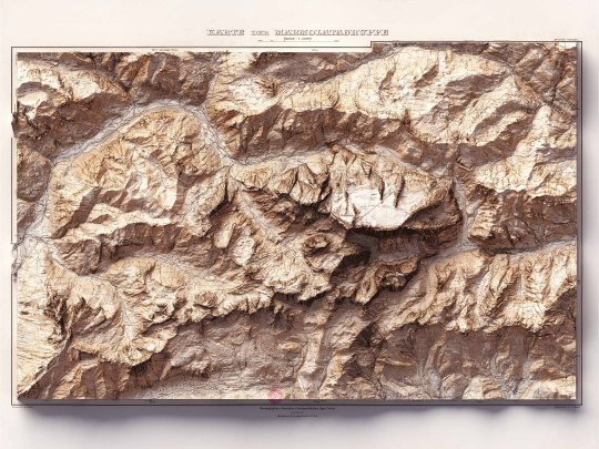
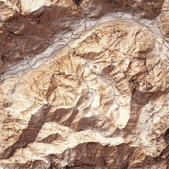
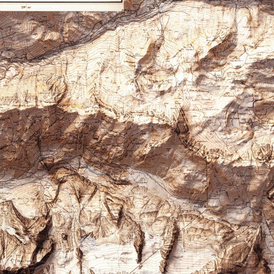
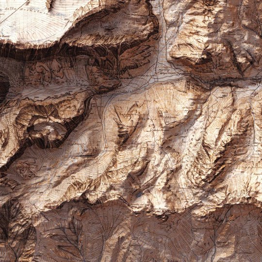
Today we show you the queen of the Dolomites: the Marmolada. The original map was made in 1926 by Freytag-Berndt. We restored it and gave it new life with shaded relief. If you like our work, want to see our daily updates (or want to say hello to our studio), consider to follow our Instagram or Twitter account. Otherwise if are interested in our prints or have a custom request check our shop.
#mountains#mountainlife#mountainlovers#dolomites#dolomitesunesco#dolomitesitaly#marmoladaglacier#marmolada#marmoladapassofedaia#cartography#cartographyart#mapart#digitalmaps#shadedrelief#geography#dataviz#geospatialdata#geospatial#gis#3dlandscape#vizart
3 notes
·
View notes
Text
💼 Upgrade Skill QGIS & ArcMap + Jadi Reseller! Potongan Harga s/d 75%
Mau kerja di bidang pemetaan digital? Pelajari QGIS 3 dan ArcMap 10 dari nol, dan mulai bisnis reseller GIS. Komisi 50%! Daftar sekarang, diskon hingga 75%!
#PelatihanQGIS#ArcGISIndonesia#DigitalMapping#KursusSIG#BelajarOnline#ResellerSIG#QGISTraining#DiskonPelatihan#KerjaOnline#BisnisSampingan
0 notes
Text
Behind the Scenes of Google Maps – The Data Science Powering Real-Time Navigation

Whether you're finding the fastest route to your office or avoiding a traffic jam on your way to dinner, Google Maps is likely your trusted co-pilot. But have you ever stopped to wonder how this app always seems to know the best way to get you where you’re going?
Behind this everyday convenience lies a powerful blend of data science, artificial intelligence, machine learning, and geospatial analysis. In this blog, we’ll take a journey under the hood of Google Maps to explore the technologies that make real-time navigation possible.
The Core Data Pillars of Google Maps
At its heart, Google Maps relies on multiple sources of data:
Satellite Imagery
Street View Data
User-Generated Data (Crowdsourcing)
GPS and Location Data
Third-Party Data Providers (like traffic and transit systems)
All of this data is processed, cleaned, and integrated through complex data pipelines and algorithms to provide real-time insights.
Machine Learning in Route Optimization
One of the most impressive aspects of Google Maps is how it predicts the fastest and most efficient route for your journey. This is achieved using machine learning models trained on:
Historical Traffic Data: How traffic typically behaves at different times of the day.
Real-Time Traffic Conditions: Collected from users currently on the road.
Road Types and Speed Limits: Major highways vs local streets.
Events and Accidents: Derived from user reports and partner data.
These models use regression algorithms and probabilistic forecasting to estimate travel time and suggest alternative routes if necessary. The more people use Maps, the more accurate it becomes—thanks to continuous model retraining.
Real-Time Traffic Predictions: How Does It Work?
Google Maps uses real-time GPS data from millions of devices (anonymized) to monitor how fast vehicles are moving on specific road segments.
If a route that normally takes 10 minutes is suddenly showing delays, the system can:
Update traffic status dynamically (e.g., show red for congestion).
Reroute users automatically if a faster path is available.
Alert users with estimated delays or arrival times.
This process is powered by stream processing systems that analyze data on the fly, updating the app’s traffic layer in real time.
Crowdsourced Data – Powered by You
A big part of Google Maps' accuracy comes from you—the users. Here's how crowdsourcing contributes:
Waze Integration: Google owns Waze, and integrates its crowdsourced traffic reports.
User Reports: You can report accidents, road closures, or speed traps.
Map Edits: Users can suggest edits to business names, locations, or road changes.
All this data is vetted using AI and manual review before being pushed live, creating a community-driven map that evolves constantly.
Street View and Computer Vision
Google Maps' Street View isn’t just for virtual sightseeing. It plays a major role in:
Detecting road signs, lane directions, and building numbers.
Updating maps with the latest visuals.
Powering features like AR navigation (“Live View”) on mobile.
These images are processed using computer vision algorithms that extract information from photos. For example, identifying a “One Way” sign and updating traffic flow logic in the map's backend.
Dynamic Rerouting and ETA Calculation
One of the app’s most helpful features is dynamic rerouting—recalculating your route if traffic builds up unexpectedly.
Behind the scenes, this involves:
Continuous location tracking
Comparing alternative paths using current traffic models
Balancing distance, speed, and risk of delay
ETA (Estimated Time of Arrival) is not just based on distance—it incorporates live conditions, driver behavior, and historical delay trends.
Mapping the World – At Scale
To maintain global accuracy, Google Maps uses:
Satellite Data Refreshes every 1–3 years
Local Contributor Programs in remote regions
AI-Powered Map Generation, where algorithms stitch together raw imagery into usable maps
In fact, Google uses deep learning models to automatically detect new roads and buildings from satellite photos. This accelerates map updates, especially in developing areas where manual updates are slow.
Voice and Search – NLP in Maps
Search functionality in Google Maps is driven by natural language processing (NLP) and contextual awareness.
For example:
Searching “best coffee near me” understands your location and intent.
Voice queries like “navigate to home” trigger saved locations and route planning.
Google Maps uses entity recognition and semantic analysis to interpret your input and return the most relevant results.
Privacy and Anonymization
With so much data collected, privacy is a major concern. Google uses techniques like:
Location anonymization
Data aggregation
Opt-in location sharing
This ensures that while Google can learn traffic patterns, it doesn’t store identifiable travel histories for individual users (unless they opt into Location History features).
The Future: Predictive Navigation and AR
Google Maps is evolving beyond just directions. Here's what's coming next:
Predictive Navigation: Anticipating where you’re going before you enter the destination.
AR Overlays: Augmented reality directions that appear on your camera screen.
Crowd Density Estimates: Helping you avoid crowded buses or busy places.
These features combine AI, IoT, and real-time data science for smarter, more helpful navigation.
Conclusion:
From finding your favorite restaurant to getting you home faster during rush hour, Google Maps is a masterpiece of data science in action. It uses a seamless combination of:
Geospatial data
Machine learning
Real-time analytics
User feedback
…all delivered in seconds through a simple, user-friendly interface.
Next time you reach your destination effortlessly, remember—it’s not just GPS. It’s algorithms, predictions, and billions of data points working together in the background.
#nschool academy#datascience#googlemaps#machinelearning#realtimedata#navigationtech#bigdata#artificialintelligence#geospatialanalysis#maptechnology#crowdsourceddata#predictiveanalytics#techblog#smartnavigation#locationintelligence#aiapplications#trafficprediction#datadriven#dataengineering#digitalmapping#computerVision#coimbatore
0 notes
Text
How to add Location in Google Maps | YMA PRO TECH
Open Google Maps, find the location, right-click (tap and hold on mobile) to drop a pin. Click the pin, select "Add a missing place," enter the name, category, address, and details. Adjust pin placement if needed. Add photos/videos. Review and submit. Wait for Google's verification process.
youtube
#GoogleMaps#AddLocation#NewPlaceOnMaps#MapUpdates#LocalBusiness#PlacesNearMe#MapContributions#MapEditing#UserGeneratedContent#CrowdsourcedMaps#LocalGuides#MapMaking#MapData#OpenStreetMap#CitizenCartography#DigitalMapping#GeoSpatialData#LocationBasedServices#MapYourWorld#MappingCommunity#MapEverything#GeoTags#PlaceMarkers#PinDropping#MapCollaborations#LocationSharing#CrowdsourcedPlaces#MapYourCity#Youtube
0 notes
Text
I will do 5000 google map citation for local business SEO gmb ranking

#GoogleMapCitation#LocalSearch#GeoTagging#DigitalMapping#LocationAccuracy#MapSEO#MapVisibility#BusinessListing#MapMarketing#CitationManagement
0 notes
Text
Ei rongin choromapti te dekha jachhe Britain-er bibhinno anchole bola hoy thaka English-er boichitromoy uccaron o upobhasha. Protiti elaka tar notun ekta dhoni o bhasha-styil niye gore uthche, ja ei desh-er samriddho bhasha-shanskritir proman.

More
#Map #TravelMap #MapLovers #Geography ExploreTheWorld #TravelGoals #Wanderlust
#MapArt #Cartography TravelGuide #AdventureMap #WorldMap MapsOfTheWorld #TravelInspiration TravelTips #DigitalMap TravelCommunity #TravelPhotography #DiscoverPlaces #MapDesign
0 notes
Text
TURISIAN.com – PT Jasa Marga membeberkan hasil evaluasi pelayanan selama libur Isra Mi'raj dan Tahun Baru Imlek 2925. Evaluasi tersebut disampaikan langsung kepada Direktur Jenderal Bina Marga Kementerian Pekerjaan Umum (PU), Roy Rizali Anwar. Pertemuan tersebut digelar di Pos Pantau Cikampek Utama, Kabupaten Karawang, pada hari Minggu, 2 Februari 2025. Dalam paparannya, Direktur Operasi Jasa Marga, Fitri Wiyanti, melaporkan bahwa total volume kendaraan yang meninggalkan wilayah Jabotabek selama periode libur Isra Mi'raj dan Imlek mencapai 1,43 juta kendaraan. Jumlah tersebut terhitung sejak 24 Januari hingga 1 Februari. Dimana Angka ini merupakan akumulasi dari empat Gerbang Tol (GT) utama. Keempat GT tersebut adalah, GT Cikampek Utama (arah Trans Jawa), GT Kalihurip (arah Bandung), GT Ciawi (arah Puncak), dan GT Cikupa (arah Merak). "Volume lalu lintas yang meninggalkan Jabotabek ini meningkat 11,3 persen dibandingkan arus normal, yang biasanya mencapai 1,28 juta kendaraan," ujar Fitri. Tak hanya itu, Jasa Marga juga mencatat peningkatan kendaraan yang kembali ke wilayah Jabotabek sebanyak 1,41 juta kendaraan. Atau, naik 14,3 persen dari arus normal yang biasanya hanya 1,09 juta kendaraan. Sementara itu, menghadapi arus mudik dan balik Lebaran 2025 atau Idul Fitri 1446 Hijriah, Jasa Marga berkomitmen untuk terus mengedepankan visi pelayanan publik berbasis teknologi dan kolaborasi. BACA JUGA: Rencana Pembangunan Jalan Tol Dalam Kota Bandung Dilanjutkan Peningkatan kapasitas infrastruktur "Strategi ke depan mencakup percepatan pelebaran jalan tol. Peningkatan kapasitas infrastruktur. Dan, optimalisasi platform digital seperti Jasamarga Integrated Digitalmaps (JID)," jelas Fitri. Sedangkan, Direktur Pengembangan Usaha Jasa Marga, M. Agus Setiawan, menambahkan bahwa perusahaan terus mengoptimalkan layanan rest area. Yaitu, melalui sistem pengendalian parkir berbasis Intelligent Transport System (ITS) dengan Rest Area Management System (RAMS). "Kami terus meningkatkan pelayanan, termasuk informasi kapasitas parkir, penyediaan Stasiun Pengisian Kendaraan Listrik Umum (SPKLU), dan posko kesehatan," kata Agus. Sementara, Dirjen Bina Marga Kementerian PU, Roy Rizali Anwar, memberikan apresiasi atas kinerja PT Jasa Marga. Mereka dinilai telah bekerja maksimal dalam melayani masyarakat selama periode libur tersebut. "Jasa Marga patut diapresiasi karena telah siaga dan memanfaatkan teknologi mutakhir untuk memberikan kemudahan dan kenyamanan kepada pengguna jalan," ucap Roy. Dengan berbagai inovasi dan strategi yang telah disiapkan, Jasa Marga berharap dapat terus memberikan pelayanan terbaik. Terutama dalam menghadapi puncak arus mudik dan balik di masa mendatang. ***
0 notes
Text
National Lacrosse League Expands League-Wide Activationfor Award-Winning 'Every Child Matters' Initiative

The National Lacrosse League (NLL) today announced the return and expansion of its “Every Child Matters” initiative. The multi-faceted platform brings awareness to the forcible placement of Indigenous children in residential and boarding schools by the Canadian and United States governments from the 19th century to as recently as 1996. This year’s campaign will begin this coming weekend and will run through March 10th.
Now in its third year, all 15 NLL teams will participate in the campaign, including specially designed helmet decals supporting “Every Child Matters” worn by all players for the remainder of the season.
“Our continued work with Indigenous athletes and communities is a major priority for the National Lacrosse League, and the ‘Every Child Matters’ education process and activations are key components of that platform,” said NLL Commissioner Brett Frood. “This program presents an opportunity to facilitate meaningful conversations about the atrocities perpetrated by the residential and boarding school systems, continue the journey toward reconciliation, and honor survivors and their families.”
The “Every Child Matters” initiative is a part of the NLL’s ever-growing participation and awareness programs tied to Indigenous culture, which is at the core of the League’s values and the history of the sport of lacrosse. The work includes educational programs for athletes, coaches, staff, and fans, land acknowledgment ceremonies, and charitable and social responsibility programs to strengthen and enhance the ties between League stakeholders and the Indigenous community.
The NLL will also produce audio and video messaging for broadcasts on TSN and ESPN, and additional content will be incorporated into NLL.com, the League’s social channels, and in-venue game presentations.
Fans will be able to purchase cotton shirts through the league’s online stores, NLLShop.com and NLLStore.ca. For every shirt sold, the NLL will donate to the Gord Downie & Chanie Wenjack Fund (DWF) in Canada and The National Native American Boarding School Healing Coalition (NABS) in the United States.
DWF is inspired by the tragic story of an Indigenous boy, Chanie Wenjack, and the commitment of a modern-day folk singer, Gord Downie. The organization seeks to enhance the well-being of Indigenous peoples through heightened awareness, education, and a reconciliation among all Canadians. NABS is leading the movement for truth, justice, and healing in the U.S. Its work is focused on research, education, and healing, and is currently advocating for legislation in Congress to establish a Truth and Reconciliation Commission on Indian Boarding School policies (H.R. 7227).
There were 523 Indigenous boarding schools operating in the U.S. and 130 Indigenous residential schools in Canada, and 13 NLL teams play within a couple hours of one or more of these sites. To learn more about these schools and their locations, please visit https://boardingschoolhealing.org/digitalmap/
The League will continue to use an “Every Child Matters” logo designed by Justin Gilbert of Kuvua Designs. Gilbert was selected due to his work in support of Indigenous organizations and his connection to the cause, being born and raised on the Southern Ute Reservation. The logo contains the silhouette of an Indigenous child wearing a ribbon shirt and holding a traditional wooden lacrosse stick. The text “Every Child Matters” appears next to the image with a heart and feather.
0 notes
Text

Map for the project created!! So excited to see it starting to come together :D
#map#fantasy map#fantasy#continent#mapmaking#cartography#design#art#mapdesign#d&d#dungeonsanddragons#d&d maps#uni#uniwork#graphic design#illustration#digital#photshop#photoshopart#digitalmap
4 notes
·
View notes
Text
Online delivery companies should stop making these 5 mistakes
Gone are the days when online shopping was just a convenient option and used by a particular set of people. Today it has become an important way for businesses to engage as it is used by a majority of people especially after the pandemic. The lockdown and the new norms of maintaining physical distance insisted people to order everything online be it groceries, vegetables, fruits or apparels. The increased demand of online shopping also increased the number of online stores and number of parcels that logistics companies have to handle on daily basis.
For most of the people placing orders online and receiving parcels were more like a part of the daily routine. Besides, as orders for essentials and daily consumables were being placed there was an urgency and everyone wanted to receive their placed orders as soon as they can, to ensure their day-to-day activities can go on smoothly. But, during this time when bulk orders were being handled and time was of great importance, it came to realization that there are some loopholes in the current process of delivery that not just impact the operational efficiency but also has huge impact on the customer satisfaction and overall online experience.
So, let us have a look at some of the most common mistakes that these online delivery companies make.
Poor understanding of the address
Inaccurate address is a serious problem in India. The wrong postal or area codes, poor landmark sharing practices and congested roads often increase the delivery time significantly. It is because of these issues that a delivery person has to call you again and again to get better understanding of your address. If you have ever ordered something online, then even you must have had similar experience. It is not sure that who must be blamed for the poor addressing issue, but it definitely is a serious concern for both the consumer and the delivery company. Suppose a delivery boy has 60 parcels to be delivered in a day and he takes 15-20 minutes to understand one address then you can imagine the amount of extra time that he spends in a day to do this unproductive work. Besides, if we look at it from the consumer’s point of view then even if he has only 2 deliveries scheduled for the day from two different vendors then 2-3 phone calls per parcel means, 4-6 unnecessary calls in a day. And sometimes due to an important meeting or any other engagement you end up missing these calls which in turns postpones your delivery by two to three days. This creates serious trouble if you were expecting your medicines or groceries to be delivered urgently.
Asking for directions during the way
There are various incidents of delivery boys disturbing the whole traffic and being the cause of traffic jams. It is a normal scene on roads where delivery guys are seen stopping without any indication disturbing the whole traffic on the road and even while talking on phone, they take turns without giving any left or right indication which leads to traffic snarls and even accidents. This not only poses a threat on everyone’s safety but also increases the delivery time. Today when daily thousands of couriers or parcels are delivered and hundreds of delivery boys are on road, it becomes more than important to address this addressing issue and present the professionals with GPS location app that allows them to track the location and reach on the destination without disturbing the traffic and putting people’s safety at risk. Besides, the GPS navigation is super easy to use, and anyone can use it without any hassle. Also, the delivery companies don’t have to worry about making any investment as most of these apps are available for free and can be easily downloaded from App Store or Google Play Store depending on the operating system of the phone.
Cliched and ineffective approaches
Today, when GPS for ecommerce is gaining popularity, we are still relying on drop down menus for address sharing. The whole inaccurate addressing issue can be resolved if we move to smarter solutions where a consumer is allowed to point his location on a map or share a route guide in audio format. Imagine how easier reaching to an address will become if you knew the exact route, the right path and even have a recorded audio where you are explained from where to take a turn or which route to take and which one to avoid. Thankfully, today apps with map APIs are available where a consumer can easily point his location on the Map and even give instruction on route choices. With these types of apps you can easily avoid calling consumers again and again for understanding the address or asking passerby for directions.
Inability to provide ETA
As companies don’t have clear understanding of the location of the consumer’s house, they are not able to give expected time of arrival. As a result, they generally only give a range (40-50 mins) and not able to share the exact time of the arrival of your parcel. But, with the GPS location app the business can take proper understanding of the address and give proper time for the arrival of the parcel. This can improve the overall delivery experience for the consumer as well as allow companies to make the whole process efficient and deliver more parcels in a day.
One simple solution to all the above-mentioned issues is better addressing system and improved GPS navigation with a more personalized approach. The Pataa app is an innovative app that simplifies your long complex address into short and unique custom code. Based on location intelligence, this makes your address easy to share, remember, search and navigate. This smart and seamless digital addressing solution simplifies all the issues that arise due to complex addresses and optimizes commuting, navigation, logistics and last-mile delivery. The navigation technology lets you minimize fuel wastage and your carbon footprint too.
1 note
·
View note
Text

Give your business a global identity by building your brand online. Give us a call to work out an effective digital marketing strategy to connect directly with your customers online. WhatsApp: https://wa.me/919535555225
#business#brand#digital#building#marketingstrategy#work#june#softwarecompany#digitalmap#seo#digtalmarketing#socialmediamarketing#googleads#marketingdigital
1 note
·
View note
Text
💼 Upgrade Skill QGIS & ArcMap + Jadi Reseller! Potongan Harga s/d 75%
Mau kerja di bidang pemetaan digital? Pelajari QGIS 3 dan ArcMap 10 dari nol, dan mulai bisnis reseller GIS. Komisi 50%! Daftar sekarang, diskon hingga 75%!
#PelatihanQGIS#ArcGISIndonesia#DigitalMapping#KursusSIG#BelajarOnline#ResellerSIG#QGISTraining#DiskonPelatihan#KerjaOnline#BisnisSampingan
0 notes
Photo

Tegg felt very small on his first day at Mitsuhama’s ARK no.06 Deep Fusion facility. “Whoa, this place is wicked huge.”—Martin F. Tegg #isthisart #synthography #aiart #aigeneratedart #aiartcommunity #digitalart #digitalillustration #digitalmedia #digitalmap #cyberpunk #cyberpunch #shadowrun #sixthworld #2053 #midjourney #midjourneyart #midjourneyai #midjourneyartwork #midjourneycommunity https://www.instagram.com/p/CooHzO9u4zS/?igshid=NGJjMDIxMWI=
#isthisart#synthography#aiart#aigeneratedart#aiartcommunity#digitalart#digitalillustration#digitalmedia#digitalmap#cyberpunk#cyberpunch#shadowrun#sixthworld#2053#midjourney#midjourneyart#midjourneyai#midjourneyartwork#midjourneycommunity
0 notes
Photo
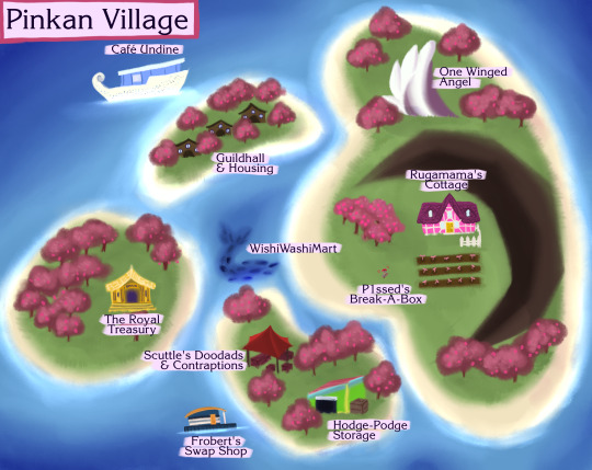
Running a set of #Pokemon #PokemonMysteryDungeon #TRPG campaigns soon, so thought I'd make a map for the starting town! ===
website // twitter // insta // fb // patreon // ko-fi // redbubble
#pokemon#pokemonmysterydungeon#pmd#trpg#pokemontrpg#digitalart#digitalillustration#map#digitalmap#trpgmap
1 note
·
View note