#OpenStreetMap
Explore tagged Tumblr posts
Visit Tumblr Blog
Explore Tumblr blogs with no restrictions, modern design and the best experience.
Last Seen Tumblr Blogs


Fun Fact
US Tumblr user growth rate is estimated to slow down to 4.1%.
Text
Excerpt from this story from Grist:
The day I was supposed to join a group of young women to map Gros Islet, an old fishing village on the Caribbean Island of St. Lucia, I got lost. Proann Francis, who was helping lead the expedition, had told me to meet everyone at Care Growell School, which Google Maps informed me was some 8,500 miles away, in Uttar Pradesh, India. “Where?” I asked. She instructed me to wait outside my hotel for a ride because it would be impossible to find the place on my own. An hour later, I found myself standing at the side of a dusty St. Lucian highway as a vintage red Toyota van pulled up. I squeezed in, between Francis and the driver. Behind us, a group of young women sat wearing matching light blue shirts that read “Women Mappers.”
“We have some heavy mapping to do today!” Francis announced, breaking into a toothy smile, her dark hair pulled back neatly into a bun.
Most of St. Lucia, which sits at the southern end of an archipelago stretching from Trinidad and Tobago to the Bahamas, is poorly mapped. Aside from strips of sandy white beaches that hug the coastline, the island is draped with dense rainforest. A few green signs hang limp and faded from utility poles like an afterthought, identifying streets named during more than a century of dueling British and French colonial rule. One major road, Micoud Highway, runs like a vein from north to south, carting tourists from the airport to beachfront resorts. Little of this is accurately represented on Google Maps. Almost nobody uses, or has, a conventional address. Locals orient one another with landmarks: the red house on the hill, the cottage next to the church, the park across from Care Growell School.
Our van wound off Micoud Highway into an empty lot beneath the shade of a banana tree. A dog panted, belly up, under the hot November sun. The group had been recruited by the Humanitarian OpenStreetMap Team, or HOT, a nonprofit that uses an open-source data platform called OpenStreetMap to create a map of the world that resembles Google’s with one key exception: Anyone can edit it, making it a sort of Wikipedia for cartographers.
The organization has an ambitious goal: Map the world’s unmapped places to help relief workers reach people when the next hurricane, fire, or other crisis strikes. Since its founding in 2010, some 340,000 volunteers around the world have been remotely editing OpenStreetMap to better represent the Caribbean, Southeast Asia, parts of Africa and other regions prone to natural disasters or humanitarian emergencies. In that time, they have mapped more than 2.1 million miles of roads and 156 million buildings. They use aerial imagery captured by drones, aircraft, or satellites to help trace unmarked roads, waterways, buildings, and critical infrastructure. Once this digital chart is more clearly defined, field-mapping expeditions like the one we were taking add the names of every road, house, church, or business represented by gray silhouettes on their paper maps. The effort fine-tunes the places that bigger players like Google Maps get wrong — or don’t get at all.
276 notes
·
View notes
Text
[요약]OSM 안의 서구와 동양의 관점 차이에 대하여
오픈스트리트맵[OpenStreetMap;OSM] 체제에 내재된 이념 혹은 정체성과 관련하여 OSM 커뮤니티에 글을 하나 올렸습니다. – 오픈스트리맵의 정체성을 무엇이라고 설명할 수 있습니까?(영문) 그리고 그에 대해 어떤 분이 ‘Imagico’라는 이에게 공유를 해 보라고 권해서 링크를 남겼더니 ‘오픈스트리트맵 안의 개인주의 대 집단주의 그리고 아나키즘 대 권위‘라는 글을 써 주셨습니다.꽤 깊이있는 내용이라 제가 번역을 엄두내기는 어려웠고, 그래서 챗지피티에게 요약과 설명을 부탁했더니 아래와 같은 의견을 주었습니다. 제공해주신 링크의 글은 OpenStreetMap(OSM) 내의 문화적 차이, 특히 서구와 동양의 관점 차이를 다루고 있습니다. 글쓴이는 한국의 OSM 기여자인 dreamy님의 댓글을…
3 notes
·
View notes
Text
Ende April 2025
Mehrere Stunden ohne Internet – so geht's
So war das Rausgehen mit der Technik im Juni 2011, so war es im September 2011, so war es 2014, so war es 2015, so war es 2017, so war es im April 2018, so war es im Oktober 2018, so war es im August 2011 und 2020.
Diesmal sind wir drei Tage in den schottischen Highlands, davon voraussichtlich 48 Stunden ohne Handyempfang. Ich nehme eine Powerbank mit 10.000 mAh mit. Ich würde gern mehr mitnehmen, finde die größere mit den 20.000 mAh aber gerade nicht wieder. Deshalb muss ich auch meine mobile Bauchheizung zu Hause lassen.
Mit der Powerbank werde ich mein Handy etwa zwei Mal vollständig aufladen können. Ich weiß nicht so genau, wie oft das im Alltag nötig ist, weil ich das Handy bei jeder Gelegenheit ans Ladekabel anschließe. Wir laden beide unsere Handys im Auto mit dem Zigarettenanzünder-USB-Adapter während der ganzen Fahrt, so dass sie beim Loslaufen voll sind. Vorsichtshalber schalte ich dann den Batteriesparmodus dauerhaft ein. Den Flugmodus noch nicht, weil ich auf dem Hinweg herausfinden möchte, bis wohin der Handyempfang reicht, damit ich weiß, wie weit ich zurücklaufen müsste, um einen Notruf abzusetzen.
Als der Empfang nach den ersten fünf Kilometern verschwindet, schalte ich den Flugmodus ein. Zum Navigieren benutze ich OpenStreetmap, das funktioniert (wenn man vorher das Kartenmaterial für die Region runtergeladen hat) offline.
Hauptsächlich benutze ich das Handy in den 48 Stunden ohne Internet, um nachts im Schlafsack Bücher zu lesen. Das Display habe ich dabei auf "weiße Schrift auf schwarzem Hintergrund" gestellt, das spart Energie. Ich mache es aber nachts auch zu Hause so, weil es weniger grell ist. Kurz vor dem Ende der Mobilfunkversorgung habe ich noch schnell ein E-Book gekauft. Als dieses Buch gelesen ist, suche ich auf dem Gerät nach anderen Büchern. Die aktuell ausgeliehenen Libby-Bücher sind mir zu kompliziert oder nicht interessant genug, und bei zwei frisch ausgeliehenen habe ich vergessen, sie vor dem Verschwinden des Internets zu öffnen, damit sie auch offline verfügbar sind. Aber ein paar Relikte aus der Kindle-Zeit und ein paar gekaufte Kobo-Bücher sind zufällig auf dem Handy, also lese ich die eben noch mal. Ich nehme mir vor, beim nächsten Mal vor dem Verlassen des Internets darauf zu achten, dass genug Offline-Lesestoff vorhanden ist.
Für das Lesen von mehreren Büchern, ein paar Fotos und gelegentliche Blicke auf die OSMand-App brauche ich unerwartet wenig Strom, so dass die Powerbank auf dem Rückweg noch halb voll ist. Aleks geht es genauso, er sagt, seine Powerbank (10.000 mAh) sei eigentlich überdimensioniert und eine kleinere, leichtere für die Berge würde reichen. Jedenfalls an Orten, an denen es kein Internet gibt. Wenn es Internet gäbe, würden wir mehr stromverbrauchende Dinge mit den Handys machen.
Aleks hat eine Stirnlampe dabei, die er besitzt, weil er im Dunkeln mit dem Hund raus muss und dabei beide Hände für das Leinenmanagement braucht. Ich benutze nur die Taschenlampenfunktion meines Handys und kann mich nicht erinnern, wann ich zuletzt eine Stirnlampe benutzt, gebraucht oder vermisst habe. Ich besitze zwei, sie liegen zu Hause und ihre Batterien sind leer. Wenn eine davon aufladbar wäre, würde ich sie vielleicht mitnehmen.
Mein Duolingo-Streak wird für zwei Tage unterbrochen, das lässt sich nicht ändern. Zwei Tage sind aber genau die maximale Zeit, die man dort mit "Streak Freezes" überbrücken kann. Bei Wordfeud verliert man nach 72 Stunden durch Timeout und ich habe nicht daran gedacht, vor dem Losgehen noch schnell in allen Spielen einen Zug zu machen. Aber auf dem Rückweg taucht das Internet in Stunde 71 wieder auf.
(Kathrin Passig)
#Kathrin Passig#offline#Openstreetmap#E-Book#Powerbank#Strom#Flugmodus#Taschenlampe#Stirnlampe#Großbritannien
5 notes
·
View notes
Text
OpenStreetMap to Stop Cheetah Trafficking
ITA version ESP version
Behind the glamorous social media photos of cheetah cubs lies a dark reality. With fewer than 7,000 individuals in the wild, the cheetah (Acinonyx jubatus) is one of the world’s most endangered species, and the illegal trade of live cubs, especially in the Horn of Africa, is devastating its populations. Poachers take cubs from their mothers while they hunt, selling them into the luxury pet market at prices reaching $50,000 per cub. Between 2020 and 2023, this trade increased by 50%, posing a serious threat to the species' survival.
However, a new methodology developed by a research team could finally help monitor and disrupt illegal cheetah trafficking through a three-tiered approach. Scientists are mapping not only the trafficking routes but also previously undocumented cheetah populations, combining prey species distribution models, habitat suitability, and a trafficking network based on OpenStreetMap data.
The first step involves locating cheetah prey, such as gazelles and antelopes, which are essential for their survival. The team used Maxent, a machine learning method, to cross-reference prey presence data with environmental variables like climate and land cover, thus mapping the most suitable areas for cheetah survival. This step identifies key conservation areas and, unfortunately, those most vulnerable to poaching.
Based on these data, researchers developed a Habitat Suitability Index (HSI) specific to cheetahs, highlighting areas where their survival is most probable. This model identifies regions with optimal conditions for stable populations and locates areas at risk of trafficking, enabling targeted interventions.
Finally, a model was created to understand how traffickers move cheetahs from remote origin areas to Arabian Peninsula markets. By integrating OpenStreetMap data on roads, ports, and border crossings, researchers identified the most likely land and sea routes and main transit points. Route optimization tools mapped out trafficking “hotspots,” allowing law enforcement to plan strategic interventions at critical crossing points, such as less monitored ports and borders.
This model is a breakthrough in conservation, as it not only enables mapping and monitoring of trafficking routes but also reveals previously undocumented cheetahs, giving scientists and conservationists a more complete picture of the situation. With this discovery, we finally have a system to protect one of Africa’s most iconic species and provide local communities with a tool to defend their natural resources.
See You Soon and Good Science!
source

#OpenStreetMap#cheetah trafficking#conservation#poaching#Africa#cheetah cubs#wildlife#exotic animals#illegal trafficking#environmental protection#Maxent#wildlife monitoring#scientific research#endangered species#ecosystem#Drops of Science#Natural Sciences#News#New#Animals
2 notes
·
View notes
Text
Hey there. Since the original map I've shared has been taken by Google for "violation of their terms of services" and someone had shared about an alternative map of the factories. This maps shares the contracts above the pins this time with purple and black ones.
PLEASE SPREAD THE WORD ABOUT IT AND BOYCOTT THE FACTORIES
3 notes
·
View notes
Video
youtube
Quick OSM effective data collection
2 notes
·
View notes
Text
OpenStreetMap - An open source online street map

Google Maps is incredibly useful - but did you know there's an open source equivalent? OpenStreetMap has been running for quite some time, and is a community driven replacement for Google, Bing and Apple maps. https://www.openstreetmap.org/
It's accessible via website, but there's also an app version which you can get for your phone which can be used similarly to Google Maps. The sat-nav functions aren't as good as other company-based products, but it does contain very good local-level information.
I've personally used it when hiking, visiting foreign cities in Europe and to create personal maps for tourist attractions, bookshops and good rock collecting spots. You can also download map data which can be used offline even if you don't have mobile signal.
They also have a community stories part of their website dedicated to the people who have used the project: https://www.openstreetmap.org/diary
If you want to support community led, open source, mapping software - do take a look at the funding page at: https://supporting.openstreetmap.org/
6 notes
·
View notes
Text
Me, a GIS professional in an office: I hate my job. Goes home, does the same job, but unpaid and with a less powerful interface: This is nice
#openstreetmap#public works#public domain#open data#And like let me say: I use ArcPro and QGIS and iD and while none of them feel particularly good to use iD is definitely the least enjoyable
3 notes
·
View notes
Text
Week 12: Crowd sourcing in times of crisis

Hey friends, we’ve made it to the final post! This week, we’re looking at how people come together online during emergencies, using crowdsourcing to share info, map crisis zones, and provide real help.
In this blog, I’ll break down what crowdsourcing is, how it works during disasters, and why it matters. We’ll look at real examples, the pros and cons, and how we can play a role as responsible digital citizens. Let’s get into it!
Crowdsourcing is the practice of obtaining services, ideas, or information by soliciting contributions from a large group of people, typically via the internet rather than relying solely on traditional experts or institutions. The concept was first popularized by Jeff Howe in 2006, who defined it as "the act of taking a job traditionally performed by a designated agent and outsourcing it to an undefined, generally large group of people in the form of an open call" (Howe 2006). In the context of crisis response, crowdsourcing enables individuals to collaborate in real time, sharing local knowledge, resources, and observations to support emergency efforts. It is especially powerful when institutional responses are delayed or overwhelmed, allowing affected communities to take an active role in information-gathering, mapping, and aid coordination (Dave 2017).

The biggest advantage of crowdsourcing during a crisis is speed. Local people can report updates as events happen, often faster than traditional authorities. It also makes use of local knowledge, which helps responders identify real needs on the ground. Crowdsourcing encourages community participation, giving people a voice in the response effort. It’s also low-cost and scalable as anyone with an internet connection can contribute.
However, there are downsides. The most pressing issue is accuracy. In emergencies, misinformation can spread quickly and cause panic. There are also privacy concerns such as sharing personal data or location can put people at risk. Lastly, Digital inequality means not everyone has access to crowdsourcing tools or reliable internet, potentially leaving out vulnerable groups such as those in rural areas, low-income communities, or conflict zones (Robinson et al. 2015).
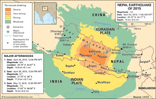
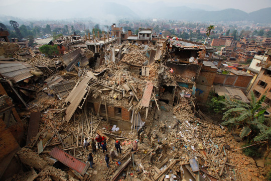
A powerful example of crowdsourcing in action is the use of OpenStreetMap during the Nepal earthquake 2015. After the disaster, much of the country’s infrastructure was damaged or unmapped, which made it difficult for aid agencies to reach affected areas. In response, thousands of online volunteers including many of outside Nepal, used satellite imagery to update OpenStreetMap. They added roads, buildings, and landmarks to help humanitarian teams navigate the crisis zone. This data was used by the Red Cross, UN agencies, and local NGOs to direct resources and plan rescues. What made this effort remarkable was the global collaboration. Volunteers didn’t need to be experts, just willing to help. This case proves that crowdsourcing, when organized and ethical, can bridge the gap between local needs and global response (Dave 2017).
youtube
As digital tools evolve, the future of crowdsourcing looks promising. Technologies can improve verification, security, and inclusivity. More governments and NGOs are also learning to integrate crowdsourced data into official disaster response. However, the key challenge will always be balancing speed with responsibility. Platforms must continue improving transparency and user safety, while users must be aware of what they share, why it matters, and who might be affected.
To sum up, crowdsourcing shows us that when people connect online with purpose, they can make a real difference. In times of crisis, digital platforms turn everyday users into part of the solution like mapping danger zones, sharing resources, and offering hope. But with this power comes responsibility. As digital citizens, it’s on us to act with care, empathy, and integrity.
Thanks for following along throughout my blogs. I’ve loved exploring these topics with you, see you!
References:
Dave, A 2017, ‘Digital Humanitarians: How Big Data Is Changing the Face of Humanitarian Response’, Journal of Bioethical Inquiry, vol. 14, no. 4, pp. 567–569.
Howe, J 2006, The Rise of Crowdsourcing, Wired Magazine, vol. 14, no. 6, viewed 11 June 2025, <https://www.wired.com/2006/06/crowds/>.
Internet Geography 2015, Nepal Earthquake 2015 - Internet Geography, viewed 11 June 2025, <https://www.internetgeography.net/topics/nepal-earthquake-2015/>.
Jay Nepal - Action Volunteers 2015, Nepal Earthquake 2015: JAY NEPAL - Action Volunteers, YouTube, viewed 12 June 2025, <https://www.youtube.com/watch?v=IYUmd_va7VM>.
Robinson, L, Cotten, SR, Ono, H, Quan-Haase, A, Mesch, G, Chen, W, Schulz, J, Hale, TM & Stern, MJ 2015, ‘Digital Inequalities and Why They Matter’, Information, Communication & Society, vol. 18, no. 5, pp. 569–582.
0 notes
Text
Mapping Detroit's Buried Waterways
by: Joanne Coutts When I started the Mapping Detroit’s Buried Waterways project in 2022, I had no idea I would still be trying to complete it 3 years and 283 miles later. This map is a screenshot of the current state of the project from my GAIA account, which I use to record tracks as I follow the routes of the buried waterways as closely as I can in real time on today’s streetscape. The base…
#2022#buried#Campbell Creek#Canada Geese#Detroit#Fox Creek#GAIA#geography#Joanne Coutts#map#mapping#openstreetmap#USGS#weeping willow
0 notes
Text
How Should We Understand and Embrace the OpenStreetMap System?
저 역시 처음엔 그랬고, 오픈스트리트맵(OpenStreetMap, 이하 OSM)을 편집하는 많은 분들이 OSM의 정체성에 대해 오해하는 경우가 많아 보입니다. 그래서 제가 이해하고 있는 OSM의 정체성에 대해 말씀드리고자 합니다. (OSM의 ‘이념’이라고 하고 싶지만 그게 공식적으로 혹은 어느 정도 공식 합의된 것인지에 대해 자신이 없어 ‘이념’이라기 보다는 가지고 있고 보이고 있는 ‘정체성’으로 표현을 하겠습니다. 굳이 ‘정체성’이라는 표현이 마음에 안 드시면 ‘이념’, ‘철학’, ‘속성’ 등 제 글에서 핵심이라고 생각되는 표현으로 바꾸어 받아들이시면 되겠습니다. 아울러 OSM에서 공식적으로 표방한 적도 없고 공식적으로 논의한 적도 없는 것으로 알기 때문에 이 글 내용은 순전히 제가 이해한 바를 얘기하는…

View On WordPress
0 notes
Text
September 2022 bis August 2023
I Walk the Line (mit Google Street View)
Am 19. September 2022 komme ich auf einem Spaziergang in der Gegend von Perth an mehreren auffälligen Warnschildern vorbei.
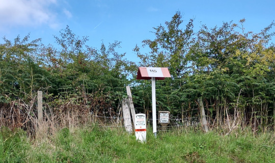
Offenbar kreuzt eine Ölpipeline hier den Weg und man darf auf keinen Fall Löcher graben, ohne vorher um Erlaubnis zu fragen.
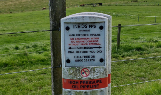
Ein paar Meter weiter stehen noch mehr Warnschilder. Ich finde das interessant, weil ich mir vorstelle, dass der Bauer hier versehentlich ein Loch in die Pipeline gemacht hat und daraufhin die vielen Schilder aufgestellt wurden. In Wirklichkeit queren an dieser Stelle einfach zwei ganz normal markierte Pipelines die Straße. Das finde ich aber erst später heraus.
Was tut eine Pipeline überhaupt an diesem absurden Ort, oben auf einem Berg? In den nächsten Tagen fallen mir an mehreren Orten in Fife solche und andere Marker auf. In Aleks' schottischem Haus kommt das Gas aus einem Rohr, aber ich habe nie darüber nachgedacht, womit dieses Rohr eigentlich verbunden ist.
Ich recherchiere ein bisschen und finde heraus: Das Rohr in Aleks' Haus ist mit dem Forties Oil Field in der Nordsee verbunden. Zwischen diesem Ölfeld und meiner warmen Dusche ist das Forties pipeline system verlegt. Einen Teil davon habe ich zufällig gefunden. Aber wo ist der Rest? Ich sehe bei Openstreetmap nach, ob diese Pipelines dort verzeichnet sind und finde: fast nichts. Bei Wikipedia: nichts. Bei den verschiedenen Unternehmen, die Pipelines in Schottland betreiben: nichts, beziehungsweise nur äußerst vages Kartenmaterial.
Aber bei Google Street View sieht man natürlich diese Marker. Die dürfen nicht unsichtbar sein, sonst würden sicher ständig bei Bauarbeiten Löcher in Pipelines gemacht. In den nächsten Tagen fahre ich sehr viel mit Google Street View durch Fife und finde Pipelinemarker. Obsessionen beginnen so harmlos, ein Moment der Unaufmerksamkeit, ein Tag mit zu viel Freizeit genügt, und schlupp hat einen das Rabbithole eingesaugt.
Am 26. September, genau eine Woche, nachdem ich mein schönes neues Hobby entdeckt habe, werden zwei große Gaspipelines bei einem Anschlag zerstört. Ich recherchiere nur noch ganz vorsichtig mit anderen Suchbegriffen um die Ecke, um mich nicht verdächtig zu machen. Aber von außen, denke ich, kann ja niemand erkennen, wozu ich nachts, wenn ich nicht schlafen kann, stundenlang mit Google Streetview über einsame schottische Landstraßen und Feldwege fahre.
Einige Wochen später weiß ich, wo Pipelines gern wohnen und wo nicht so. Es macht mir Freude, das Satellitenbild zu betrachten, "bestimmt bist du da" zu denken, und dann mit Streetview auf die Stelle zu klicken und genau beim Pipelinemarker rauszukommen. Mainlining the secret truth of the universe!
Leider kann ich nicht sofort alles bei Openstreetmap eintragen, denn dafür darf man nicht einfach die Street-View-Daten verwenden, außerdem sollte man selbst vor Ort gewesen sein. (Zur Klarstellung: Ich halte diese Regeln für sinnvoll und richtig.) Mein Versuch, Aleks für mein Projekt "Walk the Line – Hiking the FM13 Pipeline" zu interessieren, bleibt erfolglos, obwohl das bestimmt eine schöne Strecke ist.
Ich denke oft darüber nach, ob Pipelines jetzt in Karten eingetragen sein sollten oder besser nicht. In Großbritannien scheint man eindeutig dem Prinzip "besser nicht" anzuhängen. Karten sind schwer zu finden und, wenn man sie findet, so schematisch wie U-Bahn-Pläne. Aber so richtig verboten scheint es auch nicht zu sein. Für Europa gibt es ganz offizielle, wenn auch nicht immer vollständige Karten. Auch bei Openinframap sieht man einiges (auf der Basis von Openstreetmap-Daten). Damit es nicht so aussieht, als wolle ich nur die schottischen Pipelines ausspionieren, kartiere ich auch ein paar in Hessen, Bayern und Baden-Württemberg, an denen ich vorbeikomme.
Bis August 2022 bin ich eine vierstellige Kilometeranzahl mit Street View durch Schottland gefahren und habe eine recht präzise Vorstellung von den vier bis sechs großen Pipelines an der Ostküste und der dazugehörigen Infrastruktur. In die Openstreetmap-Karte konnte ich fast nichts davon eintragen, weil ich noch nicht vor Ort war. Ich erwähne mein Pipelinefindehobby H. gegenüber. Er findet es überhaupt nicht so faszinierend wie ich und sagt, dass ich die Finger davon lassen soll. Die Welt sei nicht mehr so wie früher. Er erwähnt die Bahn-Sabotage aus dem Oktober 2022, die ich komplett verpasst oder vergessen habe. "Aber die Russen können doch selber bei Street View nachsehen", wende ich ein. "Ja, aber du musst ihnen nicht auch noch die Arbeit erleichtern", sagt H.
Das alles habe ich mir auch schon selbst gedacht, aber das schöne Hobby war stärker und ich habe immer Begründungen dafür gefunden, warum es doch okay ist, Pipelines in Karten einzutragen. Zum Beispiel, weil es ja auch für an der Strecke wohnende Menschen von Interesse ist. Oder weil man auch in einer weiter entfernten Zukunft, in dem die geheimhaltenden Unternehmen vielleicht gar nicht mehr existieren, wissen möchte, wo eigentlich Leitungen im Boden liegen. (Das ist kein ganz hypothetisches Problem, Berlin hatte es nach dem Krieg und der Teilung.) Außerdem bin ich wahrscheinlich bis heute geprägt davon, dass ich mit 15 "Der Schockwellenreiter" gelesen habe, einen Science-Fiction-Roman, dessen hoffnungsvolles Ende darin besteht, dass alle geheimen Daten öffentlich werden. Aber ich habe so oft an das Falsche geglaubt im Leben, und zwar insbesondere dann, wenn ich "was soll schon sein" gedacht habe, dass ich weiß, dass H. wahrscheinlich recht hat.
Ich verabschiede mich am selben Tag von meinem Pipelinehobby und behalte nur das Wissen zurück, dass man, wenn man bei GeoGuessr (beziehungsweise Geotastic) in Schottland Pipelinemarker sieht, wahrscheinlich an der Ostküste des Landes ist.
(Kathrin Passig)
7 notes
·
View notes
Text
0 notes
Text
OpenStreetMap als Teilersatz für Komoot
Copyright OpenStreetMap Mitwirkende Viele, wenn nicht alle von uns kennen die OpenStreetMap als Karte, die in vielen Navigationssystemen und Aufzeichnung-Apps verwendet wird. Nicht nur, aber auch für Radfahren. Dass die OpenStreetMap auch für die Speicherung und Anzeige von eigenen Tracks verwendet werden kann, wissen vielleicht nicht alle, ich jedenfalls bis vor einiger Zeit auch…
0 notes
Text
walking around openstreetmap mapping again. adding places and paths to the map my beloved
1 note
·
View note