#GISTechnology
Explore tagged Tumblr posts
Visit Tumblr Blog
Explore Tumblr blogs with no restrictions, modern design and the best experience.
Last Seen Tumblr Blogs


Fun Fact
Post activity is at the highest at 4:00 pm EDT; notes peak at 10:00 pm EDT.
Text

Discover how GIS Technology enhance climate research by providing accurate mapping, spatial analysis and real-time environmental monitoring.
0 notes
Text
GIS Development Services
Leverage GIS To Perceive Data To Find New Avenues of Serviceabilities
LucidPath offers GIS solutions from logistics route planning to city utility planning solutions to better capture and leverage geospatial information at any scale.
0 notes
Text
Unlocking the Power of Location-Based Services: Your Ultimate Guide!
A location-based service (LBS) is a service provided by software for mobile device apps that requires information on the location of the mobile device. The application collects geodata, which are real-time data obtained by one or more monitoring technologies.
Technological advances and the rising availability of geolocation, GPS, and mobile data technologies have made LBS more sophisticated and accessible. This allows for the development of new and creative market applications and solutions. These elements will contribute to driving the market expansion. In addition, according to a research report by Astute Analytica, the Global Location-Based Services Market is likely to grow at a compound annual growth rate (CAGR) of 24.2% over the projection period from 2023 to 2031.
What are the various types and elements needed to run location-based services?
Push:
The application starts the location process when triggered or at daily intervals. The application then displays appropriate information to the user or device based on their geographic location. In this case, a user gets emailed an advertisement or discount after the application detects that he or she is close to a particular retail outlet.
Pull:
The application user begins the location-based service procedures. A user using a mobile map application, like Waze, to identify the nearest automated teller machine is an example of a query-based on-location service. Few services also allow users to look into concerts, restaurants, or athletic events and utilize apps like Yelp, or Google Maps.
The following four essential elements are necessary for location-based services to function:
An application that makes use of location-based services.
A geodata collection placement system.
A mobile network for data transmission or reception.
Analytics software that runs on an outside server to calculate and present relevant data to users based on their geographic location.
What technologies are utilized to track a person's location?
Based on the demand, mobile device hardware type, and available enabling technologies, various tracking mechanisms are frequently employed for location-based services:
GPS: The Global Positioning System is a network of satellites that exist only to assist in the location of objects on Earth. These satellites can be pinged by any device equipped with a GPS receiver (including various smartphones). This function enables the gadget to link up with a minimum of four satellites.
Wi-Fi: Wi-Fi location tracking differs from previous approaches. Usually, a device only links to one Wi-Fi network at a time, thus removing the chance of triangulation. Instead, IP addresses are used in this location tracking.
Each network has an actual IP address that informs the rest of the internet where it is so that data may be sent over the internet infrastructure appropriately. When a user's phone joins a Wi-Fi network, it combines with the physical IP address of that network, enabling location services to determine their current location.
Cellular technology: Cellular tracking functions similarly to GPS. User device links to cellular towers rather than satellites. In general, they'll be within the reach of at least two of the towers, allowing the system to utilize triangulation to pinpoint their location.
#LocationBasedServices#GeolocationTech#GPSNavigation#MobileApps#GeospatialData#ProximityMarketing#GeoTargeting#LocationAnalytics#GISTechnology#RealTimeLocation#GeoMarketing#Geofencing
1 note
·
View note
Text
Choosing the right GIS software in 2025: ArcGIS Pro vs QGIS 3 Analyzed I have just published a comprehensive comparison of the two leading GIS platforms as they stand in 2025. The age-old battle between proprietary and open-source solutions continues, but with fascinating new developments! Both platforms have evolved dramatically since 2020, with QGIS closing many historical capability gaps while ArcGIS Pro has leaned into enterprise integration and AI. Is your organization making the right choice? Well, the answer depends on your specific needs, budget constraints, and strategic priorities. Check out my full analysis to help navigate this critical decision for your mapping needs! Please do have a look at the post, leave a like and comment your thoughts and your experiences working with these softwares. Also do let me know which software do you think is worth investing for? Since it is the AI revolution, which software can perform tasks with utmost simplicity and efficiently, ArcGIS Pro or QGIS 3? Let's get the conversation and engagement going. Do comment, like, share and subscribe to my blog. Your engagement would mean a lot to me. Let's map the world for a sustainable future with Mapping Tomorrow. 🗺️ Subscribe to my blog website: https://mappingtomorrow.wordpress.com and get started with Mapping Tomorrow. Your one step can change your future. SUBSCRIBE NOW and be updated ahead of everyone. #ArcGISPro #QGIS3 #GISSoftware #GISComparison #GeospatialSoftware #GISTechnology #SpatialData #GISMapping #GeographicInformationSystems #OpenSourceGIS #ProprietaryGIS #GISPlatforms #MapChat #GISCommunity #SpatialAnalysis #GIScience #GeoTech #GISProfessional #GISCareer #GISJobs #GISSkills #GISEducation #GISCertification #EsriUser #QGISCommunity #OpenSourceCommunity #EsriUC #FOSS4G #UrbanPlanning #EnvironmentalGIS #BusinessIntelligence #LocationIntelligence #DataVisualization #TechComparison #SoftwareReview #2025Tech #OpenSource #TechDecisions #SoftwareEvaluation #MappingTomorrow #ProfessionalDevelopment #TechTrends #IndustryInsights #GISTwitter #MapTwitter #TechTwitter #GISLife #MappingCommunity #TechTools #GISResources #GeospatialTechnology #MappingTools
#ai#arcgispro#artificial-intelligence#cartography#education#environment#geographicinformationsystems#geospatialinelligence#geospatialtech2030#gis#gisanalysis#gissoftware#mapping#qgis#technology
0 notes
Link
Here are the most common ways #GIS is used in business and everyday life.
#sgl#igis#mapping#urbanplanning#Smartcity#gistechnology#GISApplication#GISMappingSoftware#Geomatics#Software#Technology
4 notes
·
View notes
Link
SoftTech provides a complete range of geospatial solutions ranging from base map creation, DGPS survey, and Customized web GIS service and Mobile Application.
1 note
·
View note
Link
SoftTech provides a complete range of geospatial solutions ranging from base map creation, DGPS survey, and Customized web GIS service and Mobile Application.
1 note
·
View note
Photo
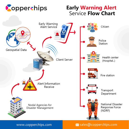
GIS technology for Disaster Management create an emergency database for people in need of all assistance in the event of a disaster. GIS helps identify disasters before they occur, using forecasts or risk zone maps.
0 notes
Photo
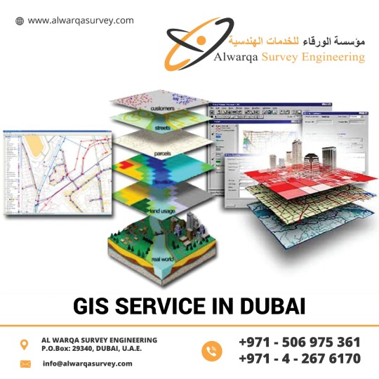
#GeographicInformationSystems can visualize spatial information, It has the power to create maps with the images.#GIStechnology offers time management. It has high accuracy, It presents higher predictions and analysis. If you want #GISServiceinDubai, UAE & Abu Dhabi #AlwarqaSurveyEngineering is the best option in terms of quality and productivity. AlwarqaSurvey Engineering provides GIS services with an all-inclusive solution for spatial data management to government and industrial organizations through #GISremotesensingservices. For More Details Phone:-+971 42676170 Email:[email protected] Website:-http://www.alwarqasurvey.com/gis-services-in-ras-al-khaimah
0 notes
Text

Explore how GIS technology revolutionizes urban planning, infrastructure, and sustainability, making cities more efficient, connected, and future-ready.
0 notes