#GPSNavigation
Explore tagged Tumblr posts
Visit Tumblr Blog
Explore Tumblr blogs with no restrictions, modern design and the best experience.
Last Seen Tumblr Blogs


Fun Fact
After the announcement of the deal with Yahoo!, there were 170K signatures of unhappy Tumblr users petitioning to prevent the sale in 2013.
Text
🔍 Discover the Fascinating World of Hebrew Directions! 🧭
Have you ever wondered how Hebrew conveys directions like 'right' and 'left'? 🌟
Prepare to be captivated by the intricacies of the Hebrew language in this super useful lesson!
Unlike English, where 'right' and 'left' often remain the same regardless of context, Hebrew has distinct words for these directions when indicating movement.
Knowing these nuances will elevate your language skills and cultural understanding when navigating Israel or conversing with Hebrew speakers.
In this short yet valuable lesson, we'll explore the Hebrew words for 'right' and 'left', and delve into their usage in different contexts.
Whether you're planning a trip to Israel, connecting with native speakers, or simply intrigued by language, this knowledge is a game-changer.
#hebrew#jewish#learnhebrew#hebrewbyinbal#language#hebrew langblr#israel#jew#torah#trending#gps#gpsnavigation#directions#left#right#which way#learn hebrew#language learning#speak Hebrew#hebrew language#jewish tumblr
12 notes
·
View notes
Text
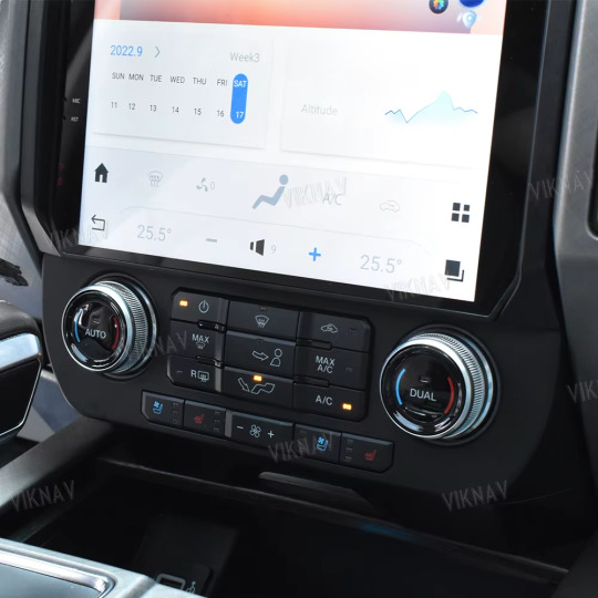
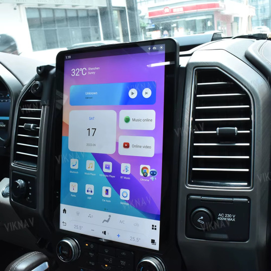

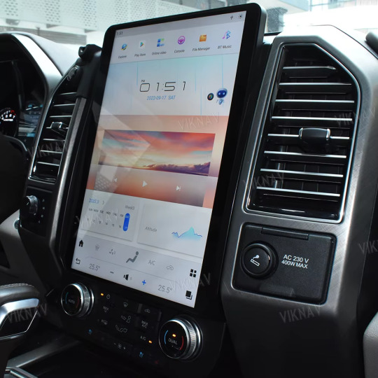
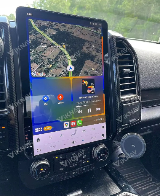
Top On Sale Product Recommendations! 14.4 inch Tesla Screen Car Radio For Ford Raptor F150 2015-2022 Car GPS Navigation Autoradio Multimedia Video Player Price Now: USD 695.00 (Original price: USD 1158.33, 40% off) 🔗Click & Buy:
#TeslaScreen#FordRaptor#F150#CarGadgets#CarAudio#GPSNavigation#MultimediaPlayer#Autoradio#TechInYourRide#UpgradeYourRide#CarEnthusiast#FordLife#RoadTripReady#InCarEntertainment#DriveInStyle#SmartCarTech#CarUpgrade#SleekDesign#CarAccessories#RaptorLife#F150Nation#AutoTech#CarLovers#ModernDriving#EpicRoadTrips#GadgetsOnWheels#ScreenUpgrade#InCarInnovation#DriveSmart#CarGoals
0 notes
Text


Order now https://netboon.com/product/gps-navigation-antenna-with-bnc-male-connector/
GPS Navigation Antenna with BNC Male Connector
#netboon#GpsAntenna#BncMaleConnector#GpsNavigation#GpsSignalAmplifier#CompactGpsAntenna#DurableGpsAntenna#GpsAccessoryForCars#GpsNavigationSystem#GpsNavigationAntenna#GpsSignalStabilizer#AccurateGpsNavigation#ReliableGpsAntenna#GpsAccessoryForVehicles#MarineGpsAntenna#AviationGpsAntenna
0 notes
Text
When it comes to fishing boats, the Lowe STINGER 198 is a powerhouse on the water. Anglers and fishing enthusiasts alike are drawn to this versatile and reliable vessel for its impressive features and top-notch performance. In this review, we will take a closer look at the Lowe STINGER 198 fishing boat to see what makes it stand out in the world of recreational fishing watercraft.
Design Features.
At first glance, the Lowe STINGER 198 presents an aesthetically pleasing appeal with its sleek contours and sturdy structure. It personifies a powerful demeanor that reflects its capabilities accurately. The boat is specifically designed to accommodate space and weight efficiency, ensuring maximum utility for anglers.
The durable aluminum hull not only adds to its robustness but also promises longevity. The attention to detail in the design is commendable as even the gunnels are designed thoughtfully for easy rod access throughout the boat.
Performance Specifications.
Equipped to ensure optimal performance, the Lowe STINGER 198 is a marvel in terms of speed, stability, and maneuverability. The power-to-weight ratio has been configured to offer maximum efficiency without sacrificing speed and stability.
With dry weight just over 1500 lbs and an impressive maximum weight capacity of 1760 lbs, this boat performs flawlessly even under extensive load use. It boasts an ample beam of 94 inches providing angling space and overall stability.
Read More: https://misterangler.com/lowe-stinger-198-fishing-boat-review/

#misterangler#mrangler#lowestinger198#fishingboat#boatreview#aluminumhull#fishingamenities#livewells#castingdeck#boatperformance#anglingspacestability#engineoptions#mercuryengines#johnsonengines#boatcomfort#deluxeseating#fishinggearstorage#digitaldash#garminechomapplus93sv#fishfinder#gpsnavigation#constructionquality#modvhulldesign#weatherresistance#handlingandmaneuverability#boatagility#customerreviews#valueformoney#recreationalfishing#boatmaintenance
0 notes
Text
#cargps#navigationsystem#markettrends#technology#innovation#automotiveindustry#gpsnavigation#smartdriving#connectedcars#navigationsolutions#locationservices#vehiclenavigation#navigationdevices#satellitenavigation#realtimetraffic#routeplanning#drivingexperience
0 notes
Text
Instanavigation – Navigate Instantly with the Best GPS Tool

Navigating through busy city streets, unfamiliar routes, or remote locations can be challenging without the right tool. With the rise of GPS technology, finding the quickest and safest path to your destination has never been easier. Instanavigation sets itself apart as the best GPS tool for those who demand speed, accuracy, and ease of use. This revolutionary app redefines the navigation experience, offering a range of features that make it the go-to solution for travelers, commuters, and explorers alike.
What Makes Instanavigation the Best GPS Tool?
Instanavigation isn't just another navigation app; it’s a smart GPS solution designed to help you navigate instantly, no matter where you are. Here's what sets it apart:
Lightning-Fast Route Calculation: The core of Instanavigation lies in its ability to calculate the fastest routes within seconds. Unlike traditional GPS apps that can take time to load and analyze, Instanavigation instantly provides you with the best available route, taking into account real-time traffic data and road conditions.
Adaptive Traffic Updates: With Instanavigation’s adaptive traffic updates, you’re always ahead of the curve. The app continuously monitors your route for any potential delays and suggests alternative paths, ensuring you’re always on the quickest track.
Seamless User Interface: Designed with simplicity in mind, the seamless user interface of Instanavigation makes it accessible to everyone. The app is intuitive, with easy-to-read maps and clear directions that even the least tech-savvy users can navigate with confidence.
Precise Location Tracking: With precise location tracking, Instanavigation uses advanced GPS technology to pinpoint your exact location, even in challenging environments like dense urban areas or remote countryside. This accuracy helps avoid wrong turns and keeps you on the right path.
Multi-Stop Route Planning: Planning a trip with multiple stops? Instanavigation’s multi-stop route planning feature allows you to add multiple destinations, optimizing the entire journey in one go. Perfect for delivery drivers, road trips, or errands around town.
Key Benefits of Using Instanavigation
Choosing Instanavigation means you’re selecting a tool that offers much more than just basic navigation. Here are the key benefits that make it the best GPS tool available:
Real-Time Navigation: With up-to-the-minute data, Instanavigation offers real-time navigation that adjusts on the fly. This ensures you’re never stuck in unexpected traffic or rerouted unnecessarily.
Offline Capabilities: Traveling to an area with limited network coverage? Instanavigation’s offline capabilities mean you can download maps in advance and still receive accurate directions without an internet connection.
Voice-Activated Commands: Keep your focus on the road with voice-activated commands. Instanavigation listens to your requests, allowing you to set destinations, find points of interest, or adjust settings hands-free.
Speed Limit Alerts: Stay safe and avoid fines with speed limit alerts that notify you if you exceed the posted speed on any given road. Instanavigation’s alerts are based on real-time data, so you’re always aware of your speed limits.
Who Can Benefit from Instanavigation?
Instanavigation is designed for anyone who needs reliable, instant navigation. Whether you’re a daily commuter, a delivery driver, a tourist in a new city, or someone who just loves road trips, this advanced GPS tool caters to your needs.
Commuters: Save time on your daily route to work with traffic-aware navigation that avoids congested areas.
Travelers: Explore new destinations confidently with accurate GPS guidance that doesn’t leave you lost or confused.
Delivery Drivers: Improve efficiency with optimized multi-stop routes, ensuring timely deliveries without unnecessary detours.
How to Get Started with Instanavigation
Getting started with Instanavigation is quick and easy. Here’s how:
Download the App: Available on both Android and iOS platforms, you can easily download Instanavigation from your app store.
Set Up Your Preferences: Customize the app settings to match your navigation needs, such as route preferences, speed limit alerts, and voice commands.
Start Navigating: Enter your destination and begin your journey. With real-time updates and instant rerouting, you’ll always be on the best path.
Conclusion
Instanavigation is not just about getting from point A to point B; it’s about doing it smarter, faster, and more efficiently. As the best GPS tool on the market, it combines cutting-edge technology with user-friendly features that make every trip a breeze. Navigate instantly with Instanavigation and experience the difference it can make on your journeys. Download Instanavigation today and take control of your routes like never before.
1 note
·
View note
Text
🌄 10 Safety Tips for an Unforgettable Backpacking Trip in Remote Areas of Hawaii 🌄

Hey adventure seekers! 🌿 Ready to dive into Hawaii's hidden gems? Imagine lush forests, majestic waterfalls, and rugged coastlines calling your name. Whether you're a seasoned backpacker or a newbie, our latest blog post is packed with essential tips to ensure your adventure is both safe and unforgettable! 🌟
🚶♂️ Here's a sneak peek at what you'll learn:
Research and preparation tips for your trip
Choosing the right gear and equipment
Planning for emergencies
Staying hydrated and well-nourished
Navigation and knowing your surroundings
Being aware of potential risks and hazards
Trusting your instincts
Respecting the environment and local culture
🔗 Read the full article here: 10 Safety Tips for an Unforgettable Backpacking Trip in Remote Areas of Hawaii!
Why is this essential?
🌿 Proper preparation can make or break your adventure 🌿 Essential gear tips to stay safe and comfortable 🌿 Navigation skills to avoid getting lost 🌿 Understanding local culture and environment for a more enriching experience
Your safety and enjoyment are our top priorities! Click the link above and get ready to embark on a memorable backpacking journey through Hawaii's wild lands.
🌺 Share your thoughts: Have you ever backpacked in Hawaii? What was your experience like? We'd love to hear your stories and tips! Let’s inspire each other to explore these incredible islands safely and responsibly. 💬❤️
Thank you for being part of our community! If you find our content helpful, please like, reblog, and consider supporting us. Your support helps us continue providing high-quality, informative content for all adventurers out there.
#backpackingtrip#Hawaii#TravelTips#OutdoorAdventure#HikingSafety#RemoteAreas#WildernessSurvival#NatureExploration#TravelSafety#AdventureTravel#Camping#BackpackingGear#EmergencyPreparedness#NavigationSkills#HikingGear#TravelPreparation#OutdoorSafety#TravelPlanning#EnvironmentalAwareness#LocalCulture#SurvivalTips#FirstAid#Hydration#Nutrition#GPSNavigation#WildlifeSafety#WeatherPreparedness#LightweightGear#Trekking#EcoFriendlyTravel
0 notes
Text
🌐✈️ Mastering Navigation: The Power of GPS! ✈️🛰️
🛰️GPS, the backbone of modern aviation navigation! 🛫 From satellites to your cockpit, GPS provides pilots with accurate positioning, velocity, and time information globally.
🛰️ RAIM, the GPS safeguard! 🔒✨ Receiver Autonomous Integrity Monitoring ensures accurate navigation. Without it, GPS accuracy is at risk.
🛰️WAAS: Elevating GPS Precision! 🚀 WAAS improves GPS accuracy, integrity, and availability. It's the key to using GPS for takeoff through precision approaches. #WAAS #PrecisionApproach
GPSNavigation #FlightTechnology #AviationExplained #SkyRevolution
avelflightschool #GPSRAIM #AviationSafety
#WAAS#PrecisionApproach#GPSNavigation#FlightTechnology#AviationExplained#SkyRevolution#avelflightschool#GPSRAIM#AviationSafety#aviation
0 notes
Text
Unlocking the Power of Location-Based Services: Your Ultimate Guide!
A location-based service (LBS) is a service provided by software for mobile device apps that requires information on the location of the mobile device. The application collects geodata, which are real-time data obtained by one or more monitoring technologies.
Technological advances and the rising availability of geolocation, GPS, and mobile data technologies have made LBS more sophisticated and accessible. This allows for the development of new and creative market applications and solutions. These elements will contribute to driving the market expansion. In addition, according to a research report by Astute Analytica, the Global Location-Based Services Market is likely to grow at a compound annual growth rate (CAGR) of 24.2% over the projection period from 2023 to 2031.
What are the various types and elements needed to run location-based services?
Push:
The application starts the location process when triggered or at daily intervals. The application then displays appropriate information to the user or device based on their geographic location. In this case, a user gets emailed an advertisement or discount after the application detects that he or she is close to a particular retail outlet.
Pull:
The application user begins the location-based service procedures. A user using a mobile map application, like Waze, to identify the nearest automated teller machine is an example of a query-based on-location service. Few services also allow users to look into concerts, restaurants, or athletic events and utilize apps like Yelp, or Google Maps.
The following four essential elements are necessary for location-based services to function:
An application that makes use of location-based services.
A geodata collection placement system.
A mobile network for data transmission or reception.
Analytics software that runs on an outside server to calculate and present relevant data to users based on their geographic location.
What technologies are utilized to track a person's location?
Based on the demand, mobile device hardware type, and available enabling technologies, various tracking mechanisms are frequently employed for location-based services:
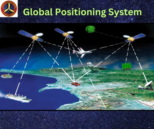
GPS: The Global Positioning System is a network of satellites that exist only to assist in the location of objects on Earth. These satellites can be pinged by any device equipped with a GPS receiver (including various smartphones). This function enables the gadget to link up with a minimum of four satellites.
Wi-Fi: Wi-Fi location tracking differs from previous approaches. Usually, a device only links to one Wi-Fi network at a time, thus removing the chance of triangulation. Instead, IP addresses are used in this location tracking.
Each network has an actual IP address that informs the rest of the internet where it is so that data may be sent over the internet infrastructure appropriately. When a user's phone joins a Wi-Fi network, it combines with the physical IP address of that network, enabling location services to determine their current location.
Cellular technology: Cellular tracking functions similarly to GPS. User device links to cellular towers rather than satellites. In general, they'll be within the reach of at least two of the towers, allowing the system to utilize triangulation to pinpoint their location.
#LocationBasedServices#GeolocationTech#GPSNavigation#MobileApps#GeospatialData#ProximityMarketing#GeoTargeting#LocationAnalytics#GISTechnology#RealTimeLocation#GeoMarketing#Geofencing
1 note
·
View note
Text
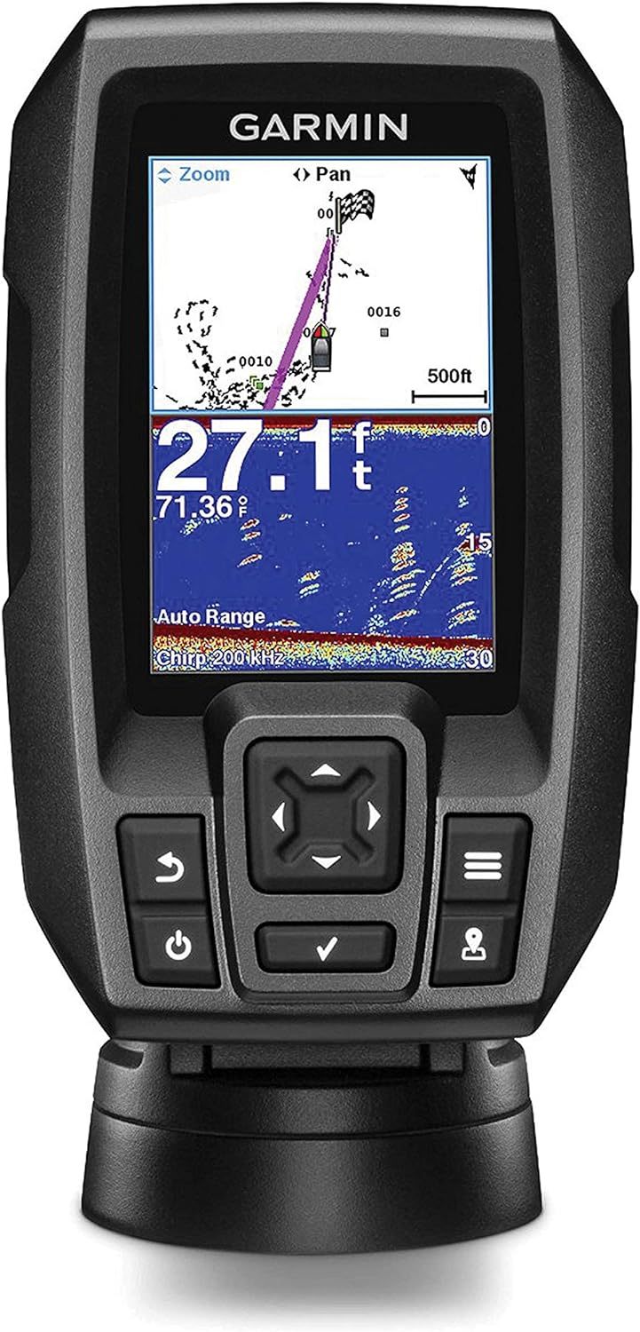
Unleash the Power of Precision Fishing with the Garmin Striker 4 GPS Fishfinder
Introduction: Embark on a fishing journey like never before with the Garmin 010-01550-00 Striker 4 with Transducer. As an avid angler or a dedicated fishing charter enthusiast, you understand the importance of having cutting-edge technology on board to maximize your catch. In this review, we delve into the features that make the Garmin Striker 4 a game-changer in the world of GPS fishfinders,…
View On WordPress
0 notes
Text
⛏️🚜 Mining Robots? Autonomous Machines Are Digging Up a $10.3B Market!
The adoption of autonomous mining vehicles is revolutionizing the mining industry by enhancing safety, efficiency, and productivity in harsh environments.
To Request Sample Report : https://www.globalinsightservices.com/request-sample/?id=GIS10857 &utm_source=SnehaPatil&utm_medium=Article
These self-driving vehicles, including autonomous haul trucks, drills, and loaders, utilize AI, LiDAR, GPS, and real-time data analytics to navigate complex terrains and optimize material transportation. With machine learning-driven route optimization and collision avoidance systems, these vehicles significantly reduce operational risks while ensuring continuous, 24/7 mining operations. By minimizing human intervention in hazardous conditions, such as underground mines and unstable open pits, companies are reducing accidents and improving overall worker safety.
Beyond automation, connected fleets and IoT-based predictive maintenance enable real-time monitoring of vehicle performance, fuel consumption, and wear-and-tear analytics. The integration of 5G networks and edge computing ensures seamless communication between autonomous vehicles, optimizing fleet coordination and reducing downtime. Additionally, the rise of electric and hybrid-powered mining vehicles is contributing to sustainability efforts by lowering carbon emissions and fuel costs. As demand for smart mining solutions increases, autonomous mining technology is set to redefine resource extraction, operational efficiency, and environmental responsibility in the mining sector.
#autonomousmining #smartmining #aiinmining #roboticmining #miningautomation #miningtechnology #selfdrivingvehicles #mininginnovation #futureofmining #digitalmining #predictivemaintenance #heavyequipment #miningengineering #5gtechnology #iotinmining #remotemonitoring #machinelearning #intelligentautomation #electricminingvehicles #smartmachinery #autonomoushaultrucks #sustainablemining #gpsnavigation #roboticdrilling #miningrobots #miningoperations #automationinmining #smartconstruction #aiapplications #innovationinmining #aiinfrastructure #digitaltwins #automatedmining #heavyindustrytech #earthmovingtechnology #excavationtec
0 notes
Text
Smart Watch SIM Card Dual
Stay connected effortlessly with the Smart Watch SIM Card Dual, designed for those who demand versatility. Featuring dual SIM support, this sleek wearable lets you manage two numbers seamlessly—perfect for balancing work and personal life. Make calls, send texts, and access 4G/LTE data directly from your wrist, no phone required. Track your health with real-time heart rate monitoring, sleep analysis, and step counting, while GPS keeps you on course. Built for durability, it’s water-resistant and sports-ready, with a vibrant touchscreen and customizable watch faces. Enjoy all-day battery life, iOS/Android compatibility, and instant notifications for apps, emails, and more. Whether you’re a multitasking professional or an adventurer, this watch keeps you in control—anywhere, anytime. Unleash
#SmartWatchSimCardDual #DualSIM #4GLTEWatch #StandaloneSmartwatch #FitnessTracker #GPSNavigation #WaterResistantTech #HeartRateMonitor #AndroidiOSCompatible #SmartwatchFreedom

#jewellery#jewelrylovers#jewel the beetle#jewelry#life quotes#love quotes#luxury#m3m jewel#watch#fantasy#watchblogging#yokai watch#thoughts and watching you suffer#watch me masturbate#watches#watcher#luxury watches#men's watches#just watched#casio watches#thinking smart#smartphone#smart home devices#smartinvesting#smartwatch
0 notes
Video
youtube
China GPS Smart Control Screen and Best Motorcycle Navigation Screen Rec..
China GPS Smart Control Screen: Top Motorcycle Navigation Screen Recommendations!
🎥✨ Discover the latest in motorcycle navigation technology with our video on "China GPS Smart Control Screen Factory and Best Motorcycle Navigation Screen Recommendations"! 🚴♂️💨
Join us as we explore innovative GPS solutions straight from the factory, showcasing the best motorcycle navigation screens on the market. Whether you're a daily commuter or an adventure seeker, we've got you covered with top recommendations to enhance your riding experience! Don’t miss out on tips for choosing the perfect navigation screen for your needs.
👉 Watch now and gear up for your next ride!
Website:https://www.teejoin.com/
Global Sources:http://www.globalsources.com/teejion.co
Alibaba:https://teejoin.en.alibaba.com/productlist.html
#MotorcycleNavigation #GPSTechnology #SmartControlScreen #RidingAdventure #TechReview #lcdscreen #motorcycletravel #GPSNavigation #L300Trackers #gps #trackers #futuretechnology #smartphone #smarthometech #futuretech #navigation #CHINAFactoy #Innovation #IntelligentNavigation #navigationDevice #smartdevices #navigationScreen #smarttechnology #smartlive #smartproducts #carplay #smartproducts #MotorcycleNavigator #motorcyclenavigation #Android #androidscreen #liunx #LiunxScreen
.
0 notes
Text
Order now https://netboon.com/product/28dbi-gps-navigation-antenna-with-tnc-male-connector-for-faster-gps-signals-capturing/
28dBi GPS Navigation Antenna with TNC Male Connector for Faster GPS Signals Capturing


#Netboon#GPSAntenna#GPSnavigation#highgainantenna#TNCconnector#GPSIGNALcapture#GPSAccuracy#AviationGPS#MarineGPS#AutomaticGPS#28dbiGPSantenna
0 notes
Video
youtube
Garmin inReach Mini 2, Lightweight and Compact Satellite Communicator
Stay Connected Anywhere with the Garmin inReach Mini 2 - Your Ultimate Satellite Communicator
Description:
Introducing the Garmin inReach Mini 2, the lightweight and compact satellite communicator that ensures you stay connected no matter where your adventures take you. Whether you're hiking, boating, or exploring remote areas, the inReach Mini 2 provides reliable communication, tracking, and safety features, making it an essential tool for outdoor enthusiasts.
Why Choose the Garmin inReach Mini 2?
Global Satellite Coverage: With Iridium satellite network coverage, the inReach Mini 2 keeps you connected worldwide, even in the most remote locations.
Compact and Lightweight Design: Weighing just 3.5 ounces, this compact communicator easily fits in your pocket or backpack, making it ideal for any adventure.
Two-Way Messaging: Stay in touch with family and friends with two-way text messaging, even when you're off the grid.
SOS Alerts: In case of an emergency, send an interactive SOS to the 24/7 search and rescue monitoring center for help.
GPS Navigation: Plan your routes and navigate with confidence using the built-in GPS and preloaded topographic maps.
Key Features:
Weather Forecasts: Receive up-to-date weather information, including detailed forecasts, to plan your activities and stay safe.
Battery Life: Enjoy up to 90 hours of battery life in tracking mode and up to 24 days in power-saving mode.
Bluetooth Connectivity: Pair the inReach Mini 2 with your smartphone to access additional features and sync contacts for seamless communication.
Track and Share Location: Share your location with loved ones and allow them to track your journey in real-time through the Garmin Explore™ website.
Rugged Durability: Built to withstand harsh environments, the inReach Mini 2 is water-resistant and meets military standards for shock and vibration.
Customer Reviews:
⭐️⭐️⭐️⭐️⭐️ "The Garmin inReach Mini 2 is a game-changer for my outdoor adventures. It's lightweight, reliable, and provides peace of mind knowing I can communicate from anywhere." - Jane D.
⭐️⭐️⭐️⭐️⭐️ "I love the compact design and the ability to send messages from remote locations. The SOS feature gives me confidence when exploring off the grid." - Mike S.
Stay Safe and Connected with the Garmin inReach Mini 2!
Don't let remote locations limit your communication. The Garmin inReach Mini 2 ensures you're always connected, no matter where you are. Click here https://youtu.be/kS3v2m4x5lU to purchase your Garmin inReach Mini 2 today and take your adventures to the next level!
#GarminInReachMini2 #SatelliteCommunicator #OutdoorAdventure #StayConnected #GPSNavigation #TwoWayMessaging #SOSAlerts #LightweightGear #RuggedDurability #ExploreWithConfidence
0 notes
Text
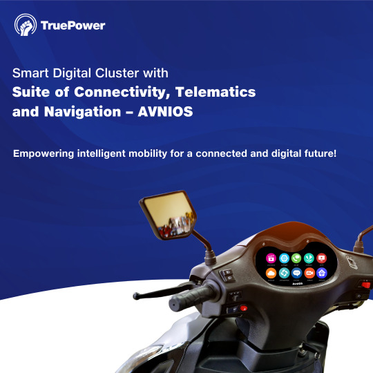
🚘 ⚡Revolutionizing Your Ride: AVNIOS - Jio's Automotive Smart Digital Cluster Embark on the next era of intelligent mobility with AVNIOS, an innovative suite crafted for electric-powered vehicles. Our touchscreen display brings real-time insights, GPS navigation, and seamless connectivity to your fingertips. Powered by JIO 4G and Humsafar Platform, AVNIOS is the future of riding where innovation meets convenience. Experience the future of riding with our Connected Auto IoT Solution. The solution ensures a complete touch free and personalized experience with real-time diagnostics and multimedia capabilities for its rider. Stay connected, stay informed, and stay ahead of the curve. #JioAVNIOS #SmartDigitalCluster #IntelligentMobility #RealtimeInsights #GPSNavigation #SeamlessConnectivity #Innovation #IoTSolution #StayConnected #StayInformed
0 notes