#Geospatial Awareness
Explore tagged Tumblr posts
Visit Tumblr Blog
Explore Tumblr blogs with no restrictions, modern design and the best experience.
Last Seen Tumblr Blogs


Fun Fact
If you dial 1-866-584-6757, you can leave an audio post for your followers.
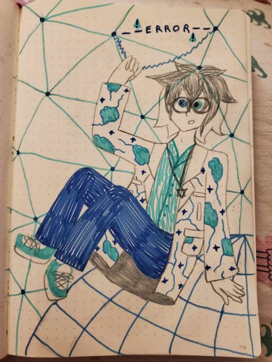
Text
i jack off to gifs of rotating cubes to improve my geospatial awareness.
17 notes
·
View notes
Text
🌟 Life at Sabaragamuwa University of Sri Lanka: A Journey Beyond Academics

🔗 Official Website: https://www.sab.ac.lk/
Nestled in the beautiful hill country of Belihuloya, the Sabaragamuwa University of Sri Lanka (SUSL) is not just an institution for higher education—it’s a complete ecosystem for knowledge, innovation, and personal growth. With a unique blend of nature, academic excellence, cultural diversity, and student engagement, SUSL has established itself as one of the most vibrant universities in Sri Lanka.
Let’s explore what makes this university a truly holistic learning experience.
🎓 Academic Excellence Through Diverse Faculties
SUSL houses several faculties, each tailored to deliver industry-relevant, research-based, and skill-oriented education. Here’s a deeper look:
🧑🌾 Faculty of Agricultural Sciences
Preparing students for climate-resilient and technology-driven agriculture, this faculty integrates practical fieldwork, lab-based research, and modern agritech practices.
Specialized areas: Agribusiness Management, Plantation Management, and Crop Science.
Facilities include a university farm, greenhouses, and plant tissue labs.
💼 Faculty of Management Studies
This faculty is a hub of innovation, leadership, and entrepreneurship.
Offers degrees in Marketing, Accounting, Business Management, and Tourism.
Strong industry links, internship programs, and a business incubation center help bridge theory and practice.
🖥️ Faculty of Computing
A newly established and rapidly growing faculty, offering degrees in cutting-edge areas like:
Software Engineering
Computer Science
Data Science
Information Systems Students benefit from modern computing labs, coding competitions, and project-based learning in collaboration with the tech industry.
⚙️ Faculty of Applied Sciences
Focused on STEM (Science, Technology, Engineering, Mathematics) education and research.
Departments include Physical Sciences, Environmental Sciences, and Biological Sciences.
Advanced laboratory facilities and field studies enhance hands-on learning.
🧪 Faculty of Geomatics
Unique to SUSL, this faculty specializes in geospatial technologies and earth sciences.
Offers degrees in Surveying Sciences and GIS (Geographic Information Systems).
Prepares students for careers in surveying, urban planning, disaster management, and remote sensing.
🌍 Faculty of Social Sciences & Languages
Equipping students to address social, cultural, economic, and political challenges through:
Degrees in Sociology, Political Science, and Languages (English, Sinhala, Tamil).
Cultural awareness programs, language labs, and public speaking forums.
🛠️ Faculty of Technology
Focusing on future-ready technology disciplines, including:
Biosystems Technology
Engineering Technology
Construction Technology
Mechatronics This faculty emphasizes problem-solving, research, and design thinking in all its programs.
🌱 A Campus That Breathes Sustainability
SUSL is set amidst lush greenery, forests, and a reservoir, promoting a deep respect for the environment.
Sustainable practices include rainwater harvesting, waste management, and plastic-free zones.
Nature trails, eco-clubs, and conservation projects give students opportunities to learn from nature while preserving it.
🧑🎓 Student Life: Balance Between Study and Fun
✨ Daily Life
Classes in the morning
Study groups under trees or by the lake
Canteen meals with friends
Sports and clubs in the evening
Quiet study or hostel activities at night
🌐 Cultural Diversity
With students from all over the island, SUSL celebrates:
Sinhala & Tamil New Year festivals
Multilingual debates
Intercultural nights and exhibitions This diversity builds respect, unity, and lifelong friendships.
🏆 Extra-Curricular Excellence
SUSL students shine beyond the classroom. The university supports:
Sports
Cricket, rugby, badminton, athletics, martial arts, and more
Regular inter-faculty competitions and national-level representation
Clubs & Societies
Gavel Club – for public speaking
IEEE & IT Clubs – for coding and tech
Environmental Society – for sustainability
Music, Dance, Drama Societies – for cultural expression
Rotaract & Leo Clubs – for leadership and volunteering
🏛️ Facilities & Campus Life
🏠 Hostels with a peaceful and secure environment
📚 A fully-equipped library with digital and physical resources
🧪 Modern laboratories and research centers
🍛 Affordable and clean canteens
🚌 Campus shuttle and scenic walking paths
🧑⚕️ Health Center with medical and counseling services
📶 Wi-Fi zones and tech support
🔮 Looking Ahead
Sabaragamuwa University is committed to global expansion and academic innovation:
Partnerships with international universities
Smart classrooms and e-learning systems
Plans for new faculties and programs
Research funding and student entrepreneurship support
💬 Final Words
Sabaragamuwa University of Sri Lanka is more than a place to earn a degree—it's a place to grow, lead, and inspire. From nature lovers to tech enthusiasts, from business leaders to language experts, SUSL has something for everyone.
✅ Visit the official website to explore more: https://www.sab.ac.lk/
— Written by Rashmi Tharaka Sewwandi
2 notes
·
View notes
Text
Sabaragamuwa University: Where Education Meets Tranquility and Innovation
Sabaragamuwa University of Sri Lanka (SUSL) is a renowned public university located in the scenic town of Belihuloya, Balangoda. Established in 1991 and officially recognized as a full university in 1995, SUSL has grown into a hub of academic excellence, research, and community development.
🌿 Campus & Environment
Nestled amidst the lush greenery of Sri Lanka’s central highlands, the university offers a peaceful and inspiring environment ideal for learning and research. The natural surroundings not only support academic activities but also provide a calming atmosphere for students and staff.
🎓 Academic Structure
SUSL consists of several faculties, each focusing on specialized fields of study:
Faculty of Agricultural Sciences – Focused on modern agricultural practices and innovation.
Faculty of Applied Sciences – Offers diverse programs in environmental science and technology.
Faculty of Geomatics – Specializes in surveying, mapping, and geospatial technologies.
Faculty of Management Studies – Provides business and management education.
Faculty of Social Sciences & Languages – Focuses on human behavior, societies, and languages.
Faculty of Medicine – Aims to develop skilled and compassionate healthcare professionals.
Faculty of Graduate Studies – Coordinates all postgraduate programs across faculties.
Faculty of Computing – Offers cutting-edge programs in Computer Science, Software Engineering, and Information Systems, preparing students for careers in the digital world.
Faculty of Technology – Focuses on technological education, integrating theory with hands-on experience in fields like Engineering Technology and Biosystems Technology.
🔬 Research & Innovation
SUSL is committed to advancing knowledge through impactful research. It supports interdisciplinary research, encourages innovation, and works with industry partners to bring new ideas to life. The university also values indigenous knowledge and promotes blending traditional wisdom with modern scientific practices.
🌐 Community Engagement & Outreach
The university actively contributes to society through various outreach initiatives. It offers distance learning opportunities, conducts career guidance programs, and supports local development through education and awareness campaigns. These efforts reflect SUSL’s mission to make higher education more inclusive and meaningful.
🏅 Student Life & Extracurriculars
Student life at SUSL is vibrant and enriching. The university supports a wide range of extracurricular activities, including sports, cultural events, and student-led clubs. Participation in national university games and inter-university events helps foster teamwork, leadership, and holistic development.


For more information, visit the official SUSL website.
#SabaragamuwaUniversity#SUSL#SabaragamuwaPride#LifeAtSUSL#SriLankaUniversities#UniversityLife#CampusVibes#HigherEducation
2 notes
·
View notes
Text
Data Visualization: Transforming Data into Insight
In an technology wherein information is produced at an remarkable tempo, the ability to extract significant insights is extra vital than ever. Data visualization plays a vital function on this procedure, enabling individuals and corporations to understand complex statistics sets, pick out trends, and communicate findings effectively. By converting abstract numbers into intuitive visuals, information visualization bridges the gap among uncooked data and human cognition, turning complexity into readability.
Data Visualization In Research

The Importance of Data Visualization
Data visualization is the graphical illustration of information and facts. By the use of visible elements like charts, graphs, and maps, statistics visualization tools make it less difficult to see and understand styles, trends, and outliers in facts. Its importance lies in numerous key areas:
Improved Understanding: Visuals are processed 60,000 times faster than textual content by way of the human mind. Graphs and charts can screen insights that would pass omitted in spreadsheets.
Enhanced Communication: Well-crafted visualizations allow statistics to be shared in a manner that’s available to a broader audience, no longer simply records analysts or statisticians.
Data-Driven Decision Making: In enterprise, governments, and medical research, visualizations support selection-making via without a doubt showing the implications of various statistics tendencies.
Pattern and Anomaly Detection: They help users quick become aware of deviations, spikes, or drops in data, which could suggest possibilities or threats.
Types of Data Visualization
Data visualization encompasses a big selection of techniques, each applicable to precise types of records and analytical desires. Some of the most commonly used sorts include:
1. Bar Charts
Bar charts are best for comparing quantities throughout classes. They are simple however effective for displaying differences among agencies.
2. Line Graphs
Often used to music changes over time, line graphs display tendencies and fluctuations, making them a fave for time-series information.
3. Pie Charts
They’re satisfactory for simple, clear percent facts.
4. Histograms
Histograms display the distribution of a dataset, making them beneficial for understanding records spread, crucial tendency, and frequency.
5. Heat Maps
Heat maps use colour gradients to indicate value depth throughout two dimensions.
6. Scatter Plots
Scatter plots are used to pick out relationships between variables, often revealing correlations or clusters in facts.
7. Box Plots
Box plots show the distribution of a dataset thru its quartiles, highlighting medians, variability, and ability outliers.
8. Geospatial Maps
These visualizations display facts associated with geographic regions and are extensively utilized in demographic research, environmental tracking, and logistics.
9. Dashboards
Dashboards integrate multiple visualizations into one interface, supplying a actual-time assessment of key metrics and overall performance signs.
Tools for Data Visualization
A huge range of tools is to be had for growing effective statistics visualizations. Popular alternatives encompass:
Tableau: A leading platform for interactive, shareable dashboards with drag-and-drop functions.
Power BI: Microsoft's enterprise analytics tool with sturdy integration into the Office atmosphere.
Google Data Studio: A unfastened tool for developing customizable reports the use of Google records sources.
Ggplot2: A effective R package for constructing state-of-the-art plots the use of the grammar of snap shots.
Each device gives distinctive competencies depending at the user’s technical information, information complexity, and desired results.
Best Practices in Data Visualization
Creating effective facts visualizations requires more than just technical skill. It includes an information of design ideas, cognitive psychology, and storytelling. Here are key exceptional practices:
1. Know Your Audience
Tailor the visualization to the information stage and pursuits of your target market. What a statistics scientist unearths intuitive is probably complicated to a business executive.
2. Choose the Right Chart
Using an inappropriate chart kind can deceive or confuse the viewer. For instance, a line chart ought to not be used for specific information.
Three. Simplify and Clarify
Avoid muddle. Focus on essential statistics and put off unnecessary elements like immoderate gridlines, decorative snap shots, or redundant labels.
Four. Use Color Thoughtfully
Color can enhance know-how but additionally lie to if used improperly. Stick to a consistent color scheme and use contrasts to highlight key points.
5. Tell a Story
Effective facts visualizations guide the viewer through a story. Highlight tendencies, anomalies, or correlations that support your message.
6. Maintain Integrity
Never manipulate axes or distort scales to magnify findings. Ethical visualization ensures accurate illustration of statistics.
Real-World Applications
Data visualization is applied in nearly each region, transforming industries through stepped forward insight and communication.
1. Business Analytics
In commercial enterprise, visualization tools assist in monitoring sales, client behavior, supply chain efficiency, and extra.
2. Healthcare
In medicinal drug and public health, visualizations are crucial for tracking disorder outbreaks, affected person records, and treatment results. For example, COVID-19 dashboards performed a main function in information the pandemic's unfold.
3. Finance
Financial analysts use records visualization to recognize market tendencies, examine investment overall performance, and check chance.
Four. Education
Educators and researchers use visualization to track pupil performance, perceive mastering gaps, and gift studies findings.
Five. Government and Policy
Policymakers use visible facts to understand social trends, aid allocation, and financial overall performance.
6. Journalism
Data journalism is growing hastily. Visual stories on topics like weather change, election results, or social inequality use charts and infographics to inform and engage readers.
Challenges and Limitations
Despite its electricity, facts visualization isn't with out demanding situations:
Data Quality: Inaccurate or incomplete information can lead to deceptive visuals.
Over-Simplification: Trying to make information too easy can lead to lack of nuance or important info.
Misinterpretation: Poor design selections or biased displays can cause audiences to draw wrong conclusions.
Tool Limitations: Not all equipment aid the extent of customization or interactivity wished for unique projects.
Overcoming these demanding situations requires a mix of technical talent, area information, and moral responsibility.
The Future of Data Visualization
The future of statistics visualization is increasingly interactive, actual-time, and AI-assisted. Emerging traits include:
Augmented and Virtual Reality (AR/VR): Immersive visualizations permit users to explore records in three-dimensional environments.
Machine Learning Integration: Algorithms can now endorse or even vehicle-generate visualizations based on the information furnished.
Collaborative Platforms: Teams can now work collectively in actual time on visualization dashboards, improving communique and agility.
These advancements will hold to make records greater accessible and insightful throughout all domain names.
Difference Between Augmented Reality (AR) and Virtual Reality (VR)
What Is Data Analysis In Research
2 notes
·
View notes
Note
hello! about that OC ask game: betrayal, break, desire, fear, and secret.
waahh thank you for answering even though no one knows about my son
this is SHAPEFILE hes (sort of?) a TMA fan character. he serves the web and to a lesser extent the vast and was made in a lab to do GIS (geospatial data science) but perhaps theres more to life than that who knows he hasnt figured it out yet
betrayal: Has your OC ever been betrayed by someone they thought they could trust? Has your OC ever betrayed someone who trusted them?
hes been betrayed in the sense that he slowly realizes that everything he was raised to believe (see: that he was created to be a corporate shill for proprietary GIS software) was not necessarily a concrete fact, which starts to break down the intricate web (TMA web literally) of the world he operates on.
as for betraying others, oh yeah, he does it all the time. doesn't even flinch. lying and selling come easily to him, and so does killing, so long as its not him that gets his hands dirty. his gods listen, and they are not benign
break: What would cause your OC to break down completely? What do they look like when that happens? Has anyone ever seen them at their lowest?
it would probably take a true shattering of his identity as a product. the moment he GENUINELY realizes that hes actually just a person who was groomed and not a product designed to serve a purpose, he'll lose his mind.
so, he doesn't realize it.
he's got schoolwork to do.
(definitely dont read anything about my own gender struggles into this lol)
desire: What's one thing your OC wants more than anything in the world? Are they open with that desire? Why or why not? What would they do to fulfill it?
he'll tell you that he wants to work for Esri and shill ArcGIS like he wa designed to. he doesn't want to be a failed prototype, like the ones who came before him. he wants to fulfill his destiny.
but, still, that's not what he really wants. he hasn't even unlocked that yet. he's not even real enough, by his own standards, to have deep-seated desires of his own.
however, that's not to say he still doesn't give into smaller desires. hes a bit of a sex addict. in fact, his creators never told him he was transgender (see: men get farther ahead in the workplace!!) until he first had sex and someone pointed out that most dudes didnt have a cunt. he was like. oh.
(arguably this is a form of betrayal too, waking up mind-wiped with a sex change you didnt exactly ask for but weren't even aware of. but hes not exactly complaining either, just confused)
fear: What is your OC's greatest fear? What do they do when confronted with it? Are they open with their fear, or do they hide it away?
probably that he'll never get that corporate job he was made for. like i said above, it would shatter him. he definitely isnt open about it. hes convinced if he works hard enough he can make it to the top
whos gonna tell him?
secret: What's one secret your OC never wants anyone to know about them?
you know? he just might actually be a person
2 notes
·
View notes
Text
https://nexusnewsfeed.com/article/unexplained/us-government-essentially-kills-ufo-disclosure-efforts-information-will-remain-classified

US Government essentially kills UFO disclosure efforts: information will remain classified
The UAP Disclosure Act, which was a beacon of hope for many advocating for transparency in the government's actions regarding UAPs, was just gutted.
UFO’s, now “Unidentified Ariel Phenomenon (UAP)” as per the US government’s re-branding of the subject, continue to make waves within the “mainstream.” This is interesting because it’s yet another topic that was firmly established as a “conspiracy theory” that has turned out to be real and worthy of discussion.
UAP themselves are real, there’s no doubt about it. Activists and journalists around the world continue to explore what these objects are and where they come from.
UAP Sightings occur every single day and continue to increase exponentially year after year. These sightings have been documented from antiquity to the present day.
On Thursday, the US Congress passed legislation that directs the government to share with the public at least some of what it knows about UAP. That being said, those who have been paying attention know that this is not a move forward, but a step backwards in trying to get the government to be more transparent about what it knows.
Remember it is the US government that has been engaged in a century long coverup of the subject, what reason does the public have to suddenly trust what government will bring forth when we’ve been lied to for so long?
Within the past few months, this legislation did look promising. It was designed to task all government departments with the responsibility of examining data sets about UAP. It was a significant step towards ALL available data on UAP. But this didn’t happen, and it’s not going to happen.
The measure, which was tucked into the annual defense policy bill that won final approval with a bipartisan vote, directs the National Archives to collect government documents about “unidentified anomalous phenomena, technologies of unknown origin and nonhuman intelligence.”
Basically, the act has been stripped of its substance and only has the ability to collect UAP reports without any clear guidelines of how these reports will be made public.
Under the provision, which President Biden is expected to sign into law, any records not already officially disclosed must be made public within 25 years of their creation, unless the president determines that they must remain classified for “national security” reasons.
The original legislature called for the government to skip any review and simply ordered the Defense Department to declassify “records relating to publicly known sightings of unidentified aerial phenomena that do not reveal sources, methods or otherwise compromise the national security of the United States.”
It would have also allowed those within the national security state to come forward to share what they know publicly about the phenomena without being punished for breaking their national security oaths.
Key provisions were gutted and watered down with this bill that basically prevents any disclosure regarding crash craft and bodies recovered.
David Grusch is a former Air Force intelligence officer who worked in the National Geospatial-Intelligence Agency (NGA) and the National Reconnaissance Office (NRO). He came forward this year sharing what he knows about the phenomenon. In the interview below with News Nation, he explains how this legislation is a complete failure.
He became one of hundreds of high ranking officials from multiple countries in the past several decades who have shared similar information. For some reason, Grusch’s testimony captured the attention of the world, and as a result, many people who were completely unaware of this issue have now become aware of it.
youtube
2 notes
·
View notes
Text
Understanding and Addressing Gambling Harms in the Northern Rivers: A Community-Informed, Multi-Site Research Initiative
1. Executive Summary
This research proposes a multi-part, cross-disciplinary study to assess gambling behaviours, harms, public perceptions, and community resources in the Northern Rivers region of NSW. Drawing on case studies, youth exposure research, and stigma analysis, the project aims to inform harm minimisation strategies, improve public health messaging, and evaluate community-based alternatives to pokies. The project will combine geospatial mapping, qualitative and quantitative methods, and collaborative partnerships with local services and affected communities.
2. Research Aims and Objectives
Overall Aim:
To provide an evidence base that supports policy and service improvements to minimise gambling harms in regional communities, with a focus on the Northern Rivers region.
Specific Objectives:
✦ Map the availability and accessibility of gambling venues and services across Byron Bay, Ballina, Lismore, and Mullumbimby
✦ Identify demographic risk factors and prevalence of gambling harms in local populations
✦ Examine stigma and barriers to help-seeking among those affected by gambling
✦ Investigate the effectiveness and perception of alternatives to pokies (e.g., Eltham Hotel case study)
✦ Compare engagement and outcomes of Gamblers Anonymous (GA) with NA/AA
✦ Analyse the impact of digital content on youth gambling exposure, including TikTok and social media platforms
✦ Develop community-informed recommendations for policy, education, and service delivery
3. RGF Priority Research Areas Addressed
This project aligns with multiple RGF priorities:
• Individual and community level harm minimisation
• Gambling among vulnerable groups
• Regulation of gambling environments
• Emerging technologies and new trends
• Measuring and understanding prevalence and harm
• Efficacy and effectiveness of treatment and support pathways
4. Methodology
A mixed-methods approach will be used across five interconnected sub-projects:
✦ 4.1 Community Gambling Profile (Northern Rivers)
• Geospatial Mapping of venue density and proximity to schools, public housing, and health services
• Community Surveys to gauge gambling habits, risk factors, and support-seeking behaviour
• Stakeholder Focus Groups with health workers, community leaders, and venue staff
✦ 4.2 Pokies-Free Pubs: Eltham Hotel Case Study
• Financial Data Analysis (pre/post pokies removal)
• Interviews with patrons, managers, and local artists
• Patronage Survey comparing motivations and perceived social atmosphere
✦ 4.3 Stigma, Treatment, and Peer Support
• Public Opinion Poll on gambling vs drug/alcohol addiction
• In-depth Interviews with individuals with lived experience of gambling harm
• Comparative Analysis of GA vs NA/AA attendance, structure, and accessibility
✦ 4.4 Youth and Digital Exposure
• Content Analysis of gambling-related posts and ads on TikTok, Instagram, YouTube
• Youth Surveys (ages 12–17) via schools and youth services
• Parent/Educator Interviews on awareness and protective strategies
5. Collaborators and Stakeholders
✦ Regional partner orgs: Social Futures, NNSWLHD, Coffs Refugee Support
✦ Academic support: University Centre for Rural Health (Lismore), Southern Cross University
✦ Community consultation: Local Aboriginal Land Councils, Gamblers Anonymous facilitators
✦ Youth organisations and schools
6. Expected Outcomes and Impact
✦ Evidence-based recommendations for regional harm minimisation and venue licensing
✦ A model for pokies-free entertainment precincts
✦ Data-informed digital literacy campaigns targeting youth gambling exposure
✦ Identification of gaps in treatment and support systems
✦ Greater insight into public attitudes and stigma reduction approaches
7. Timeline and Deliverables
PhaseTimeframeDeliverablesProject designMonths 1–2Ethics approval, stakeholder engagementData collectionMonths 3–6Surveys, interviews, mappingData analysisMonths 7–8Interim findings, media reportsFinal reportingMonths 9–10Full report, infographics, presentationDisseminationMonths 11–12Community briefings, journal submission
8. Budget (est. $180,000–$200,000)
Includes:
• Staff costs (research assistant, community liaison)
• Participant incentives (vouchers for surveys/focus groups)
• Travel and accommodation
• Data analysis software
• Community workshops and dissemination events
• Final reporting and design
In-kind contributions from partner orgs (e.g. room hire, printing, consultation hours) will be included.
9. Evaluation and Learnings
• Continuous stakeholder feedback loops (via advisory group)
• Post-project reflection workshop with community partners
• Evaluation framework focused on relevance, uptake, and future applicability
• Assessment of how findings contribute to long-term service or policy reform
10. Contact and Expression of Interest
To be submitted to:
With expression of interest requesting access to the RGF grant portal
0 notes
Text
# Draft Policy: Intelligence Framework for Detecting and Countering Embedded Corrupt Actors
---
### **Policy Number:** \[Insert ID]
### **Effective Date:** \[Insert Date]
### **Review Cycle:** Annual or as required
### **Approved by:** \[Approving Authority]
---
## 1. **Purpose**
This policy establishes the framework for the systematic collection, analysis, and dissemination of intelligence related to embedded corrupt actors within organizations, governments, and military entities who may engage in sabotage or clandestine relocation activities to Earth upon imminent detection.
---
## 2. **Scope**
This policy applies to all personnel, departments, and units involved in intelligence, counterintelligence, cybersecurity, and security operations across \[Organization/Agency]. It governs the methods and tools used to detect, monitor, and respond to insider threats and related clandestine activities.
---
## 3. **Objectives**
* Identify and mitigate risks posed by embedded corrupt actors with timely, actionable intelligence.
* Maintain continuous situational awareness of potential sabotage and clandestine relocation attempts.
* Integrate multi-domain intelligence sources and advanced analytics to detect covert threats.
* Protect organizational assets, personnel, and strategic interests from insider-enabled attacks.
* Facilitate coordinated responses with partner agencies and allied entities.
---
## 4. **Intelligence Gathering Principles**
### 4.1. **Multi-Domain Collection**
* Employ human intelligence (HUMINT), signals intelligence (SIGINT), cyber intelligence, geospatial intelligence (GEOINT), open-source intelligence (OSINT), and sensor data.
* Prioritize the integration and fusion of intelligence from diverse sources to maximize detection capability.
### 4.2. **Continuous Monitoring**
* Maintain ongoing surveillance of personnel behavior, communications, network activity, and geospatial indicators for anomalies.
* Use AI-driven tools for real-time detection of suspicious patterns and insider threat indicators.
### 4.3. **Legal and Ethical Compliance**
* Ensure all intelligence activities comply with applicable laws, regulations, and organizational ethical standards.
* Respect privacy rights and balance security needs with individual freedoms.
---
## 5. **Roles and Responsibilities**
| Role | Responsibilities |
| ------------------------------ | ----------------------------------------------------------------------------- |
| **Chief Intelligence Officer** | Overall oversight of intelligence operations and policy compliance. |
| **Counterintelligence Units** | Conduct insider threat investigations and vetting programs. |
| **Cybersecurity Teams** | Monitor and respond to cyber threats and AI integrity attacks. |
| **AI/Analytics Teams** | Develop and maintain behavioral and anomaly detection models. |
| **Operations Command** | Coordinate tactical responses based on intelligence reports. |
| **Legal & Compliance** | Review intelligence methods for regulatory adherence. |
| **Personnel Security** | Conduct background checks, psychological assessments, and continuous vetting. |
---
## 6. **Operational Procedures**
### 6.1. **Data Collection and Surveillance**
* Implement surveillance technologies and HUMINT programs according to mission priorities.
* Regularly audit AI models and data sources for integrity and bias.
* Establish secure communication channels for intelligence sharing and reporting.
### 6.2. **Analysis and Fusion**
* Utilize AI and human analysts to correlate data across domains.
* Produce actionable intelligence reports and threat assessments.
* Conduct regular red team exercises simulating insider threats.
### 6.3. **Response and Mitigation**
* Activate rapid response protocols upon detection of credible threats.
* Coordinate with law enforcement, security, and allied agencies.
* Engage in counterintelligence operations including deception and asset control.
---
## 7. **Training and Awareness**
* Provide mandatory training for personnel on insider threat awareness and reporting.
* Conduct periodic workshops on intelligence tools, ethical standards, and data protection.
---
## 8. **Oversight and Accountability**
* Establish an independent oversight committee to review intelligence activities and incident responses.
* Implement mechanisms for whistleblower protection and anonymous reporting.
* Require periodic audits and compliance reports to senior leadership.
---
## 9. **Data Security and Retention**
* Protect all collected intelligence with appropriate cybersecurity measures.
* Retain data according to legal requirements and organizational policies.
* Dispose of intelligence materials securely when no longer needed.
---
## 10. **Review and Amendment**
* This policy shall be reviewed annually or after any significant incident.
* Amendments shall be proposed by the Chief Intelligence Officer and approved by \[Approving Authority].
---
**End of Policy**
0 notes
Text
How to Prepare Your Site for 3D Laser Scanning in Dallas
As industries across Dallas—from construction to architecture and facility management—embrace advanced technologies, 3D laser scanning has become a go-to method for capturing precise spatial data. This innovative process provides accurate, high-resolution digital representations of real-world environments, enabling better planning, documentation, and analysis.
However, to get the most out of your 3D laser scanning service in Dallas, it’s crucial to prepare your site properly before the scanning team arrives. Proper site preparation ensures optimal data quality, minimizes errors, and helps you achieve faster results. Here's a comprehensive guide on how to get your site ready for a successful 3D laser scanning session.
1. Understand the Scope of the Project
Before you begin physical preparations, clarify the following:
What areas need to be scanned?
What is the intended use of the scan data (e.g., construction planning, renovation, clash detection, documentation)?
Are you expecting deliverables like point clouds, BIM models, or 2D drawings?
This information helps the scanning provider tailor their approach, select the right equipment, and allocate the appropriate resources for your Dallas-based project.
2. Clear Physical Obstructions
To capture accurate scan data, the scanner needs an unobstructed line of sight. Make sure to:
Remove vehicles, furniture, pallets, or construction debris
Open doors and move mobile partitions or equipment
Coordinate with staff to temporarily vacate high-traffic areas
For indoor sites, ensure that rooms are accessible and that windows or mirrors (which can reflect the laser) are either removed or flagged for consideration during post-processing.
3. Ensure Adequate Lighting (for Image Capture)
While 3D laser scanners do not rely on light for measuring distance (they use lasers), many also capture panoramic or photographic images. Good lighting enhances the visual documentation, which can be important for photorealistic renderings, textured models, or facility maintenance records.
If scans will occur at night or in dimly lit indoor spaces, consider supplemental lighting.
4. Inform Site Personnel and Coordinate Access
It’s essential to coordinate with your Dallas site’s stakeholders:
Notify all site personnel of the scanning schedule
Arrange access to locked rooms, roofs, basements, or other restricted areas
Ensure safety officers are aware of the work and approve necessary safety protocols
For larger commercial or industrial sites, consider assigning a liaison or escort to assist the scanning team during their visit.
5. Plan for Safety and Compliance
3D laser scanning providers follow strict safety standards, but site conditions may require specific preparations:
Ensure the area is safe to access (clear hazards, spills, unstable surfaces)
Provide PPE if required by site regulations
Communicate safety guidelines or site orientation rules in advance
This is especially relevant in active construction zones, factories, or warehouses across the Dallas-Fort Worth area.
6. Mark Important Reference Points (If Needed)
In some cases, it’s helpful to mark specific reference points or features that should be emphasized during scanning. These might include:
Utility panels
Structural columns
Wall penetrations
Equipment mounts
Additionally, if your site has survey control points or existing geospatial coordinates, provide them to the scanning team for georeferencing purposes.
7. Limit Movement During Scanning
Movement within the scanning area—such as people walking or machinery operating—can lead to inconsistencies in the data, known as "ghosting."
While not always avoidable, you can minimize these artifacts by:
Scheduling scans during off-hours
Blocking access to active scan zones
Pausing work briefly during scanning operations
This ensures clean, reliable data capture that doesn’t require extensive editing in post-processing.
8. Coordinate Timing to Fit Weather and Work Schedules
If the scanning will be conducted outdoors, keep an eye on the Dallas weather forecast. Rain, heavy wind, or low visibility can impact scanning efficiency. Plan for a dry, stable weather window whenever possible.
Also, try to schedule the scanning at a time that doesn’t conflict with major construction activity, demolition, or deliveries, which might obstruct or delay the scan.
9. Communicate Expectations Clearly
Finally, communicate your expectations and preferences clearly with the scanning service provider:
What format do you want the deliverables in?
Are you on a tight deadline?
Do you have preferred file naming conventions, CAD layering standards, or model accuracy levels?
Sharing this information ahead of time will help ensure the scanning is performed with the end use in mind, reducing the need for revisions or adjustments later.
Conclusion
3D laser scanning can unlock exceptional value for projects across Dallas, from preserving historical buildings in the Bishop Arts District to modernizing warehouses in Irving or mapping infrastructure in downtown.
By taking the time to properly prepare your site, you set the stage for a smooth, accurate, and efficient scanning process. Clear communication, site access, safety planning, and minimal obstructions all contribute to high-quality deliverables that support your goals in design, construction, inspection, or asset management.
Whether you're working on a small renovation or a large-scale development, thoughtful preparation ensures you get the best return on your investment in 3D laser scanning services in Dallas.
Let me know if you'd like a shorter version, meta description, or additional articles tailored to Dallas-based industries.

youtube
#3D Laser Scanning Service Dallas#3D Laser Scanning Dallas#3D Building Scanning Services#3d building scanning#3D Laser Scanning Services#3d laser scanning construction#3D Measurements Services#Youtube
1 note
·
View note
Text
Exploring the 7 Wonders of the World Through GIS Storytelling Maps

Why GIS Enhances Cultural Exploration
GIS connects physical space with historical narratives, offering a more immersive way to learn. By visualizing global landmarks like the Taj Mahal or Chichen Itza within a geographic context, users can grasp the broader cultural, environmental, and social dimensions of each site. GIS-based story maps foster engagement through visual interaction, spatial analysis, and multimedia content, making history more meaningful and memorable.
Benefits of Mapping Cultural Heritage
Historical Education: Discover the origin, significance, and legacy of each Wonder.
Global Geography: Learn about continents, countries, and geographic coordinates.
Cultural Diversity: Understand the values and traditions that shaped ancient civilizations.
Hands-on Learning: Encourage exploration through clickable maps and visual storytelling.
Digital Competency: Develop skills in map creation, data entry, and spatial thinking.
Tourism Awareness: Visualize how heritage sites contribute to travel and cultural economy.
Common GIS Applications
Educational Storytelling: Create curriculum-friendly, interactive visual aids.
Virtual Travel Planning: Simulate global routes and sightseeing experiences.
Exhibition Mapping: Use maps in galleries or public displays to engage viewers.
How to Build a 7 Wonders Interactive Map Using GIS
Begin by identifying the New 7 Wonders: Great Wall of China, Petra, Christ the Redeemer, Machu Picchu, Chichen Itza, Colosseum, and Taj Mahal. Use trusted sources like UNESCO to gather accurate coordinates. Select “Add Story” with the “Default” theme and create a “World Wonder” category. Manually add each site using latitude and longitude, along with details like the nearest airport, travel tips, entry fees, and itineraries. Add descriptions and images to enrich each point. Style them with relevant icons or colors. Connect the sites using straight-line airplane paths, and label each with its country name. Finally, publish and share your interactive map via link or embed for use on blogs, websites, or public displays.

Use Case: Public Exhibition & Museum Display
This interactive map format is ideal for public exhibitions and museums. Cultural institutions can integrate GIS maps into digital displays to enhance visitor engagement. Visitors can explore the 7 Wonders interactively viewing facts, photos, and travel paths on touchscreen kiosks or projection walls. This approach brings static exhibits to life, offering a tech-forward way to promote cultural appreciation and global awareness.
Using Open GIS Tools
Many platforms support education, cultural engagement, and public communication by making geospatial storytelling widely accessible. Open-source platforms like MAPOG democratize access to GIS technology, allowing users of all backgrounds to create compelling, interactive content.
Conclusion
GIS mapping transforms the way we engage with world heritage. By linking cultural history with location data, users can experience the 7 Wonders not just as destinations, but as stories grounded in geography. Whether used in museums, classrooms, or online platforms, interactive maps provide an engaging, educational, and inspiring way to connect with the past.
Start your own GIS story map today and bring the 7 Wonders to your audience!
#MapTheWonders#InteractiveLearning#DigitalGeography#EdTechInAction#GISforEducation#StudentExploration#7WondersMap#ImmersiveLearning#GlobalEducation#VisualLearning
0 notes
Text
I'm excited to share my latest in-depth analysis on how Geographic Information Systems are revolutionizing defense operations worldwide. As the author of "Mapping Tomorrow: Navigating to the World of Geographic Information System," I've explored how cutting-edge geospatial technologies are transforming military capabilities across multiple domains. In this comprehensive blog post, I examine six critical case studies that demonstrate the strategic impact of advanced GIS implementation: Indo-Pacific Maritime Domain Awareness systems integrating satellite surveillance with oceanographic modeling Humanitarian demining operations enhanced through AI-driven terrain analysis and probability mapping Urban warfare planning revolutionized by high-fidelity 3D modeling and subsurface infrastructure mapping South Asian border security monitoring leveraging multi-sensor integration and cross-border incident mapping Military humanitarian assistance powered by damage assessment automation and resource optimization Electromagnetic spectrum operations treating digital signals as mappable terrain The article also explores emerging trends that will shape the future of defense GIS, including quantum computing applications, edge computing for disconnected operations, and advanced human-machine teaming in spatial analysis. As conflicts become increasingly complex and multi-domain, superior geospatial intelligence has emerged as a decisive factor in both conventional military operations and asymmetric warfare. The organizations that most effectively leverage these capabilities will maintain significant advantages in our increasingly contested world.
View On WordPress
#ai#aiindefense#artificial-intelligence#asymmetric warfare#battlespace management#command and control systems#common operating picture#defensemapping#defensetechnoloy#dronemapping#education#environment#force multiplier technologies#force protection#geographicinformationsystems#geoint#geospatialinelligence#gis#intelligence fusion#intelligence preparation of battlefield#lidar#military decision support systems#military modernization#militaryapplications#multi-domain operations#operational planning#predictiveanalysis#RemoteSensing#strategic intelligence#technology
0 notes
Text
Geospatial Solutions Market Set to Hit $2401.1 Billion by 2035
The global market for Geospatial Solutions is expected to experience significant growth, with industry revenue projected to rise from $488.0 billion in 2023 to $2401.1 billion by 2035. This reflects a compound annual growth rate (CAGR) of 14.2% from 2023 to 2035.
Detailed Analysis - https://datastringconsulting.com/industry-analysis/geospatial-solutions-market-research-report
Geospatial solutions are essential across a wide range of applications, including precision agriculture, urban planning, logistics and transportation, as well as defense and security. The market's growth is primarily driven by the increasing adoption of geospatial technologies in key sectors such as agriculture, urban development, and defense.
Competitive Landscape and Market Leadership
The Geospatial Solutions market is highly competitive, with several key players driving innovation and market penetration. Leading companies in the market include:
Esri
Hexagon Geospatial
Trimble
Topcon
HERE Technologies
Fugro
TomTom
Geo-Insights
Blue Marble Geographics
SuperMap
Mapbox
Cyient
These companies are at the forefront of advancing geospatial technologies, such as artificial intelligence (AI), machine learning, and real-time data analytics, which are helping to meet the growing demand for smarter and more efficient solutions across industries.
Key Growth Drivers and Market Opportunities
The growth of the Geospatial Solutions market is fueled by several factors:
Precision Agriculture: The growing need for efficient land use and sustainable farming practices is driving the demand for geospatial solutions in agriculture, enabling better crop management and resource allocation.
Urbanization and Smart City Initiatives: The increasing push for smart city development and urban planning requires geospatial technologies to manage infrastructure, transportation, and urban environments more efficiently.
Defense and Security: Geospatial solutions are playing a crucial role in defense and security applications, including surveillance, reconnaissance, and situational awareness.
Integration of AI and Machine Learning: The application of AI and machine learning in geospatial data analysis is enhancing the capabilities of these solutions, enabling real-time insights and decision-making.
Demand for Real-time Location Data: The growing reliance on real-time data in various sectors, including logistics, transportation, and emergency management, is driving the adoption of geospatial technologies.
Regional Dynamics and Supply Chain Evolution
North America and Asia-Pacific are the dominant regions in the Geospatial Solutions market. Both regions benefit from strong technological infrastructure, high levels of investment, and significant demand from key industries. However, emerging markets in India, Brazil, and South Africa are becoming increasingly important for market growth, driven by rapid urbanization, industrialization, and the adoption of new technologies.
Despite challenges such as high initial investments, data privacy concerns, and integration complexities, the geospatial solutions market’s supply chain—from data providers and software developers to system integrators and service providers—is expected to evolve to meet these challenges. Companies are also focusing on strategic advancements in developing regions to diversify revenue streams and expand their total addressable market (TAM).
About DataString Consulting
DataString Consulting is a leading provider of market research and business intelligence solutions, offering a comprehensive range of services for both B2C and B2B markets. With over 30 years of combined industry experience, DataString specializes in delivering actionable insights that support strategic decision-making.
The company’s expertise spans multiple industries, providing tailored research services in strategy consulting, opportunity assessment, competitive intelligence, and market forecasting. DataString Consulting helps businesses navigate complex markets and capitalize on emerging trends to achieve long-term success.
#Geospatial Solutions#Geospatial Technologies#Market Growth#Precision Agriculture#Smart Cities#Urban Planning#Logistics and Transportation#Defense and Security#AI and Machine Learning#Real-time Location Data#Industry Trends#Market Leadership#Competitive Landscape#Emerging Markets#Data Privacy#Market Forecast#North America Geospatial Market#Asia-Pacific Geospatial Market#Market Expansion#Strategic Investments#DataString Consulting#Market Research
0 notes
Text
Mass Notification System Market Analysis: Driving Safety, Communication, and Business Continuity
In an age where real-time communication is critical to public safety, operational efficiency, and crisis management, Mass Notification Systems (MNS) have become indispensable across multiple sectors. These systems deliver critical messages during emergencies, natural disasters, IT disruptions, and public safety threats. As organizations recognize the importance of rapid, reliable communication, the Mass Notification System market is poised for significant expansion.
This article delves into the market dynamics, key trends, segment analysis, and competitive landscape that define the current and future trajectory of the MNS market.

Market Overview
The global Mass Notification System market has experienced strong growth and is expected to reach approximately USD 41.4 billion by 2026, growing at a CAGR of over 20% from 2021 to 2026. This growth is fueled by increasing threats from natural disasters, terrorism, cyberattacks, and public health emergencies—as seen with the COVID-19 pandemic.
The adoption of MNS solutions is expanding beyond traditional use in government and emergency services to encompass education, healthcare, corporate, transportation, and industrial sectors. The demand is particularly high in regions with stringent compliance requirements and high population density.
Key Market Drivers
Increased Need for Emergency Communication The growing frequency of natural disasters, mass shootings, and health emergencies has amplified the need for timely mass alerts. Governments, schools, and enterprises are investing in systems that can alert large groups within seconds.
Regulatory Compliance Compliance with safety and communication standards, such as OSHA, Clery Act, and GDPR, mandates the implementation of effective communication protocols. Organizations are adopting MNS to meet these legal requirements.
Integration with Smart Technologies The integration of MNS with Internet of Things (IoT), Artificial Intelligence (AI), and geospatial analytics allows for smarter and more targeted messaging, enhancing responsiveness and personalization during crises.
Remote Workforce Trends The shift to remote work has increased the need for distributed communication tools. MNS platforms are being adopted to provide secure, multi-channel communication across mobile apps, SMS, voice, email, and social media.
Market Segmentation Analysis
By Component
Software: The largest and fastest-growing segment, with solutions offering customizable alert rules, dashboards, and real-time analytics.
Services: Includes installation, integration, maintenance, and consulting services critical for effective system deployment.
Hardware: Comprises PA systems, display boards, sirens, and alarms used in on-premises deployments.
By Deployment
On-Premise: Preferred in high-security environments like military and defense.
Cloud-Based: Gaining popularity due to scalability, lower upfront costs, and remote accessibility.
By Application
Emergency Response
Business Continuity
Disaster Recovery
Public Alerts and Warnings
IT Alerting
By End-User
Government & Public Sector
Healthcare
Education
Energy & Utilities
Transportation and Logistics
Enterprise
Regional Insights
North America holds the largest market share, driven by advanced infrastructure, regulatory mandates, and the presence of leading vendors.
Europe follows, supported by high public safety investments and GDPR-driven compliance efforts.
Asia-Pacific is emerging as a lucrative market due to rapid urbanization, smart city initiatives, and growing digital awareness in countries like India, China, and Japan.
Latin America and MEA are also investing in modern alert systems, especially in disaster-prone and politically volatile regions.
Competitive Landscape
The MNS market is competitive and fragmented, with global and regional players offering diverse solutions. Key players include:
Everbridge Inc.
Siemens AG
Honeywell International
Eaton Corporation
Blackboard Inc.
AtHoc (BlackBerry)
Singlewire Software
Alertus Technologies
These companies are investing in R&D, strategic acquisitions, and global partnerships to expand their reach and enhance product capabilities.
Challenges and Limitations
Despite its growth, the MNS market faces certain challenges:
Privacy and Data Security: Cloud-based deployments raise concerns about data breaches and misuse of personal information.
Cost Constraints: Small and medium enterprises may find initial deployment costs prohibitive.
Integration Complexity: Ensuring compatibility with legacy systems and existing infrastructure remains a technical hurdle.
False Alerts and System Reliability: Malfunctions or errors in alert delivery can undermine trust in the system.
Vendors must address these challenges to ensure widespread adoption and long-term success.
Future Outlook
The future of the Mass Notification System market lies in intelligent, scalable, and integrated platforms. Emerging technologies like AI-powered analytics, real-time language translation, geofencing, and wearable alert devices will further revolutionize how notifications are sent and received.
As threats become more complex and widespread, organizations will continue investing in robust communication strategies. MNS will no longer be optional—it will be an essential component of risk management, public safety, and digital resilience.
Conclusion
Mass Notification Systems are playing a pivotal role in building resilient organizations and safe communities. As the market evolves with new technologies and use cases, vendors and users must stay ahead by embracing innovation, ensuring compliance, and maintaining a user-first approach. The demand for faster, smarter, and more reliable communication will drive the market toward even greater growth and transformation in the years ahead.
0 notes
Text
very funny how many of you in how many fandoms Understand this now


ANYWAY LMAO SHOW ME WHO YOU ARE OR SOMETHING LIKE THAT
NO LIKE
REAL
I HAVE ACCEPTED BEING THE FINAL BOSS COCAINE BEAR PROJECTED UPON ME IN THIS FINE MOMENT
SO LIKE
SHOW ME YOUR TRUE FORM OR SOME SHIT
CUZ THERES ONLY TWO TYPES OF PEOPLE IN THE WORLD. THOSE THAT ENTERTAIN, AND THOSE THAT OBSERVE. AND I'M A PUT ON A SHOW KIND OF "GIRL".
I'M A FUCKIN PERFORMER ALL EYES ON ME IN THE CENTER OF THE RING JUST LIKE A CIRCUS
THERE'S ONLY TWO TYPES OF GUYS OUT THERE. THOSE THAT CAN HANG WITH SOLSTICE AND THOSE THAT ARE SCARED
youtube
WHEN I CRACK THAT WHIP EVERYBODY GONNA TRIP JUST LIKE A CIRCUS
YOU BETRAYED **YOURSELF** COCAINE BEAR. THAT IS THE JOKE. LIKE-LIKE-LIKE A CIRCUS!!!
haha, to me it's just another year, to you, it's all you'll worry about.
fuckin 'ur perfectly aware', 'i'm in another geospatial position here's pics of my blackout zone' ass retard tweets between 'let me be a complete dipshit to hack into the tartaria situation a year late and piss myself into that particular bin too. Can't tolerate not rebelliously throwing myself into my own crucible directly trying to stick it to the guy I can't hop off the dick of.'
And yes, Karen, I will use words like Retard, who, as Retards, are often quite humored at themselves for being Retards. It is the people that think less of them that coil like a wounded animal when called it. I am, in fact, the Great Fool. The Great Retard, even. And you can thank cocaine bear for that.
Anything you think you don't like about me will, in fact, trace back to what you hate about you.
SPN fandom doesn't even know why it hates me. It has narrated up so many angles in a circle around me it completely lost the plot of why it's angry, and it's even angry about that. There is no concept to them of who I was as a person. Just the person they insisted on crafting me to be to fit their world view until it crumbled after me. And the crumbling into my rightness should have brought peace, but still yet they came to fight me. Reasons unclear. For the struggle of it, as Jung would say. Boredom.
Fucking coffee running cow goes @ trickster god you're a shady guy, whole chested, mid apocalypse.
Well, girls? I learned how to crack my whip and send you running at a bigger scale. I'm a performer. This is my stage. All eyes on me in the center of the ring, just like a circus.
Let's go. Are you ready? Let me see what you can do. I'm running this. Like a circus. All eyes on me in the center of the ring just like a circus!!!
You wanted a face for your final boss!! I told you two years ago it would be me but I activated really fun face cards! Your favorite person to hate at right now is Elon Musk!! Wild guess. It occasionally pivots back to hating Trump. I'm right, aren't I?
I told you the plot a year ago. Antichrist runs the show. Everyone else, masons, zionists, jesuits, they fall in line, consciously or otherwise.
I am the Ash tree Musk even named their children after, trying to force to be.
I am the result of Ash's Xorvintaal. Musk, a great seed sham. Generations of movement. Generations of great lies to become great truths.
The Word manifest.
Fuckin
piratecandyrumpockyridingsniffmakesbuttrumhoopleborpna is apparently the abrahadabra of this generation, we truly live in the most stupidest timeline.
i believe piratecandyrumpocky is fair in shorthand.
Fuckin
HOOPLEBORPNA
youtube


youtube
Fucking shadows of. Mass. Destruction.
Cuz you better be ready for this. Right now.
IT'S A FUCKING TAKE-OVER, KIDS. CAN'T RUN AWAY FROM THE BOSS.

CUZ I'M ABOUT TO TAKE DOWN THESE ENEMIES. THEY GONNA RUN WHEN THEY SEE ME.
AND THE RESULTS WILL BE DEFINITIONALLY ETERNALLY FUNNY.
MUSK IS BEYOND BONED. THE DISAPPEARING THAT IS ABOUT TO HAPPEN TO HIM IS BEYOND YOUR MORTAL GENERATIVE AI COMPREHENSION
1 note
·
View note
Text
The role of GIS in Cyber Security and Geospatial Intelligence
In today’s digital age, where cyber threats are becoming more sophisticated and widespread, the need for innovative tools to combat these risks has never been greater. Enter Geographic Information Systems, a technology that has traditionally been used for mapping and spatial analysis but is now playing a pivotal role in cybersecurity and geospatial intelligence.
This blog explores how GIS is revolutionizing industries by providing actionable insights and enhancing strategic planning.
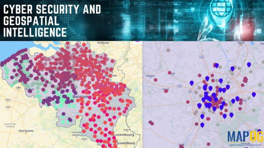
By combining the power of GIS with cybersecurity, organizations can visualize, analyze, and respond to threats in ways that were previously unimaginable. Here is step by step to enhance by using cloud based like MAPOG:
Step 1: Create a New Map
Launch Your Project: Begin by clicking the “Create New Map” button to open a fresh workspace.

Select a Base Map: Choose from a variety of base map options, such as satellite imagery, terrain views, or street maps, to establish a clear and detailed foundation for your project.

Import Data:

Step 2: Style and Analyze Your Data
. Customize Your Map:
Navigate to the “Action” button and choose “Style Layer.”
Utilize the “Heat style” feature to visualize areas with varying levels of activity, such as cybersecurity attack hotspots or regions with high user engagement.
Modify colors, labels, and icons to enhance the map’s visual appeal and clarity.

Conduct Advanced Analysis:
Access the "process data" select "Near By Neighbor" and specify the main layer, attributes, and joining layer.
Set parameters such as a 3000-meter radius and a limit of 10 results, then proceed to submit.
Refine the layer’s appearance by revisiting the “Action” button and selecting “Style Layer” for improved visualization.

The “Heat Style” feature can be employed to spotlight regions experiencing frequent cyberattacks. This visual approach simplifies resource allocation and the implementation of preventive strategies.
Step 3: Share and Collaborate
Distribute Your Map:
Share your map with others by generating a public or private link through the “Preview & Share” option.
Embed the map on websites or blogs to broaden its accessibility.
Engage with Teams:

Industries and Domains
GIS is revolutionizing multiple sectors by delivering spatial insights and improving decision-making processes. Key applications include:
Cybersecurity: Map the geographic sources of cyberattacks and safeguard military networks.
Fraud Detection: Analyze and map geographic trends in cyber fraud, such as ATM skimming.
GIS Data Used in This Example
Boundary Data: To outline the geographic scope of the map.
Police Stations: To locate law enforcement facilities.
ATMs: To assess potential hotspots for cyber fraud.
Conclusion
By harnessing the power of GIS, organizations can strengthen their cybersecurity defenses, enhance situational awareness, and make informed, data-driven decisions. Whether you’re a cybersecurity specialist, a geospatial analyst, or a researcher, MAPOG can transform your projects by delivering actionable insights through geospatial intelligence.
MAPOG is a dynamic platform that enables users to craft professional, insightful maps effortlessly. Its intuitive interface, robust analytical tools, and secure features make it an essential resource for professionals across various fields.
0 notes