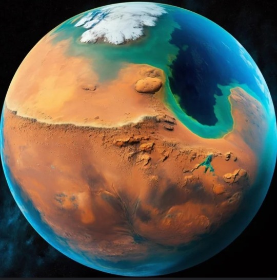
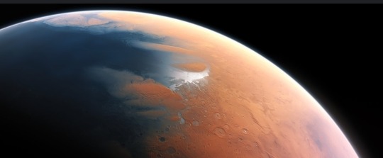
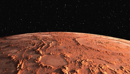
#Mars polar ice caps
Text
Baba Vanga Predicts Apocalypse Begins in 2025
Posted July 8th, 2024 by @TimcastNews
Baba Vanga Predicts THE APOCALYPSE Begins 2025 As World War 3 Will DEVASTATE Europe’s Population
ABOUT THIS VIDEO:
The video discusses a series of predictions made by the late Baba Vanga, a Bulgarian clairvoyant, known for foreseeing various global events. The focus is on her claim that the apocalypse will begin in 2025, initiated by World War III, which…

View On WordPress
#alien civilizations#apocalypse 2025#Baba Vanga predictions#clairvoyant predictions#climate change#climate crisis#communism spread 2076#environmental impact#Europe population collapse#extraterrestrial contact#future predictions#Geopolitics#global conflict#Mars war#military escalation#Nostradamus#nuclear bioweapons#polar ice caps melting 2033#sea-level rise#solar storms#space energy sources#space exploration.#Venus exploration 2028#Venus resources#World War III
0 notes
Text
Unveiling the Enigmatic Martian Structures: Clues to the Red Planet's Past
Introduction
The Martian landscape has long captivated the imagination of scientists and enthusiasts alike. Among the many mysteries that Mars presents, Martian structures stand out as some of the most enigmatic and intriguing features. These structures, which range from massive volcanoes to deep canyons and ancient river valleys, hold vital clues about the Red Planet’s history and evolution. In…
View On WordPress
#ancient river valleys#Deimos#habitability#life on Mars#Mars#Mars exploration#Martian moons#Martian structures#Olympus Mons#Phobos#polar ice caps#Tharsis Plateau#Valles Marineris
0 notes
Text

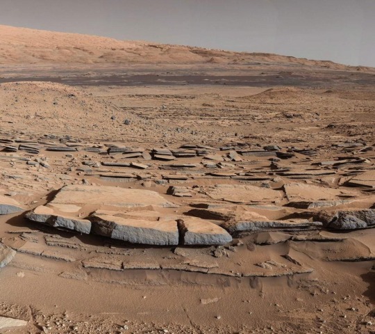
Dunes in Northern Summer
This dune field formed near the base of the North Polar cap. Dunes require a source of loose particulate material to form. The source of the northern dune fields around the polar cap may be from the layers of dusty ice that are eroded by strong polar winds.
This image was taken during the Martian northern summer, so there is no frost present on the dunes. The dunes closest to the base of the polar cap are long and parallel, indicating strong winds from the direction of the cap. As they get farther away from the polar cap, they start to form more crescent shaped dunes, called barchan dunes.
Repeated observations by HiRISE of dunes like these show measurable changes in some locations. This discovery adds to the growing evidence that there are active processes happening all over the surface of Mars today.
ID: PSP_009840_2745
date: 1 September 2008
altitude: 318 km
NASA/JPL-Caltech/University of Arizona
83 notes
·
View notes
Text
DID MARS EVER CONTAIN WATER??
Blog#428
Saturday, August 17th, 2024.
Welcome back,
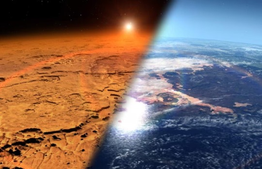
While the icy moons of Jupiter and Saturn contain water, Mars remains dry. Despite dozens of space missions, the Red Planet has yet to provide convincing proof that it conceals significant water reserves beneath its surface.
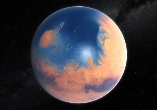
Yet Earth's little cousin hasn't always been so secretive. Various studies have shown that a little over 4 billion years ago, it experienced a "watery" era when lakes, rivers and perhaps even oceans could maintain themselves on its soil. Branching valleys and ancient terrains rich in hydrated clays are evidence of this blissful period of abundance.
Subsequently, the loss of part of the Martian atmosphere led to a reduction in the greenhouse effect followed by a gradual disappearance of water. The question is how long this process lasted and under what conditions. This is what the American Space Agency's (NASA) Curiosity and Perseverance spacecraft have been trying to establish since their arrival in 2012 and 2021 in the Gale and Jezero craters.
"Lakes occupied these depressions 3.5 or 3.6 billion years ago," explained Nicolas Mangold, a director of research at the French National Center for Scientific Research (CNRS) Laboratory of Planetology and Geosciences in Nantes.
By studying the sedimentary and clay deposits left by the former and exploring the ancient river delta that fed the latter, the aim is to determine whether the climate at the time was wet and cold, or dry and hot. The Perseverance rover is also collecting samples, to be brought back to Earth as part of the MSR mission [Mars Sample Return, NASA-European Space Agency (ESA)]. They should provide precise information."
For the moment, things are hazy. If water has flowed on Mars, where has it gone? Was it sucked up into space with the Martian atmosphere or did some of it remain on site, buried underground? Many teams around the world are working to find answers by searching for clues to its presence other than those offered by polar ice caps and glaciers.
As water cannot remain in a liquid state for long on the surface of Mars, these investigations often consist of spotting recent traces of its passage using instruments placed in orbit. This opens the way to all kinds of controversy about how to interpret observations of this world, whose morphology is radically different from that of Earth. "Some of these controversies, such as those concerning gullies – ravines 1 or 2 kilometers long, discovered by the hundreds along certain landforms in the early 2000s – have finally been settled," said Susan Conway, a CNRS researcher at the Laboratory of Planetology and Geosciences in Nantes.
Her team recently demonstrated in the journal Nature Communications that seasonal deposits of dry ice explain the phenomenon, and not water flows.
Other clues continue to fuel debate and even controversy among scientists. The nature of "equatorial dark flows," the background noise of radar signals suggesting the existence of an underground sea beneath the North Cap, the presence of possible channels in the ejecta of impact craters and the hypothetical formation of "rides" in areas of glacial retreat. If water exists on Mars, it is well camouflaged.
Why not deep underground, frozen in the cryosphere? Or preserved in liquid form in aquifers, or inside the thin film of perchlorate brine that supposedly exists at the base of the permafrost that covers Mars at high latitudes? The Marsis and Sharad radars of the Mars Express (ESA) and MRO (NASA) probes have pinpointed promising regions. And when NASA's Phoenix lander dug a few centimeters into the frozen ground just after it arrived in 2008, it immediately uncovered blocks of water ice – a further reason for hypothesis and speculation.
Originally published on https://www.lemonde.fr
COMING UP!!
(Wednesday, August 21st, 2024)
"DID LIFE EXIST ON VENUS??"
#astronomy#outer space#alternate universe#astrophysics#universe#spacecraft#white universe#space#parallel universe#astrophotography
80 notes
·
View notes
Text
According to data from the now-retired InSight lander, Mars' rotation is accelerating each year by around 4 milliarcseconds. That's a very small amount – shortening the length of a Mars day by just a fraction of a millisecond every Martian year – but the reason for it is not immediately apparent.
However, the finding could lead us to a better understanding of Mars and its past evolution. The current forerunning hypotheses explaining the acceleration are long-term trends – such as accumulating material at the polar ice caps – and interior dynamics.
"It's really cool to be able to get this latest measurement – and so precisely," says planetary geophysicist Bruce Banerdt of NASA's Jet Propulsion Laboratory. "I've been involved in efforts to get a geophysical station like InSight onto Mars for a long time, and results like this make all those decades of work worth it."
Continue Reading
94 notes
·
View notes
Text

Oceans of water found on Mars
Using seismic activity to probe the interior of Mars, geophysicists have found evidence for a large underground reservoir of liquid water — enough to fill oceans on the planet's surface.
The data from NASA's Insight lander allowed the scientists to estimate that the amount of groundwater could cover the entire planet to a depth of between 1 and 2 kilometers, or about a mile.
While that’s good news for those tracking the fate of water on the planet after its oceans disappeared more than 3 billion years ago, the reservoir won't be of much use to anyone trying to tap into it to supply a future Mars colony. It's located in tiny cracks and pores in rock in the middle of the Martian crust, between 11.5 and 20 kilometers below the surface. Even on Earth, drilling a hole a kilometer deep is a challenge.
The finding does pinpoint another promising place to look for life on Mars, however, if the reservoir can be accessed. For the moment, it helps answer questions about the geological history of the planet.
“Understanding the Martian water cycle is critical for understanding the evolution of the climate, surface and interior,” said Vashan Wright, a former UC Berkeley postdoctoral fellow who is now an assistant professor at UC San Diego’s Scripps Institution of Oceanography. “A useful starting point is to identify where water is and how much is there.”
Wright, alongside colleagues Michael Manga of UC Berkeley and Matthias Morzfeld of Scripps Oceanography, detailed their analysis in a paper that will appear this week in the journal Proceedings of the National Academy of Sciences.
The scientists employed a mathematical model of rock physics, identical to models used on Earth to map underground aquifers and oil fields, to conclude that the seismic data from Insight are best explained by a deep layer of fractured igneous rock saturated with liquid water. Igneous rocks are cooled hot magma, like the granite of the Sierra Nevada.
"Establishing that there is a big reservoir of liquid water provides some window into what the climate was like or could be like," said Manga, a UC Berkeley professor of earth and planetary science. "And water is necessary for life as we know it. I don't see why [the underground reservoir] is not a habitable environment. It's certainly true on Earth — deep, deep mines host life, the bottom of the ocean hosts life. We haven't found any evidence for life on Mars, but at least we have identified a place that should, in principle, be able to sustain life."
Manga was Wright's postdoctoral adviser. Morzfeld was a former postdoctoral fellow in UC Berkeley’s mathematics department and is now an associate professor of geophysics at Scripps Oceanography.
Manga noted that lots of evidence — river channels, deltas and lake deposits, as well as water-altered rock — supports the hypothesis that water once flowed on the planet's surface. But that wet period ended more than 3 billion years ago, after Mars lost its atmosphere. Planetary scientists on Earth have sent many probes and landers to the planet to find out what happened to that water — the water frozen in Mars' polar ice caps can't account for it all — as well as when it happened, and whether life exists or used to exist on the planet.
The new findings are an indication that much of the water did not escape into space but filtered down into the crust.
The Insight lander was sent by NASA to Mars in 2018 to investigate the crust, mantle, core and atmosphere, and it recorded invaluable information about Mars' interior before the mission ended in 2022.
"The mission greatly exceeded my expectations," Manga said. "From looking at all the seismic data that Insight collected, they've figured out the thickness of the crust, the depth of the core, the composition of the core, even a little bit about the temperature within the mantle."
Insight detected Mars quakes up to about a magnitude of 5, meteor impacts and rumblings from volcanic areas, all of which produced seismic waves that allowed geophysicists to probe the interior.
An earlier paper reported that above a depth of about 5 kilometers, the upper crust did not contain water ice, as Manga and others suspected. That may mean that there's little accessible frozen groundwater outside the polar regions.
The new paper analyzed the deeper crust and concluded that the "available data are best explained by a water-saturated mid-crust" below Insight’s location. Assuming the crust is similar throughout the planet, the team argued, there should be more water in this mid-crust zone than the "volumes proposed to have filled hypothesized ancient Martian oceans."
IMAGE: A cutout of the Martian interior beneath NASA's Insight lander. The top 5 kilometers of the crust appear to be dry, but a new study provides evidence for a zone of fractured rock 11.5-20 km below the surface that is full of liquid water — more than the volume proposed to have filled hypothesized ancient Martian oceans. Credit James Tuttle Keane and Aaron Rodriquez, courtesy of Scripps Institute of Oceanography
#science#space#astronomy#physics#news#nasa#astrophysics#esa#spacetimewithstuartgary#starstuff#spacetime#hubble space telescope#jwst
9 notes
·
View notes
Text
High obliquity (axial tilt) worlds are really very strange. The ice caps of terrestrial planets with substantial water inventories creep down from their high polar latitudes as you increase tilt, blanketing more and more of the surface in ice sheets right up until you reach a tipping point found somewhere around forty to fifty degrees. There, due to the way sunlight is distributed across the planet seasonally - like a sunbather turning over just twice a year - the ice caps suddenly migrate into a new configuration, hot polar summers driving the formation of an ice belt around the equator. We know Earth likely can't enter such a state (although a few papers claim otherwise) - the tidal influence of the Moon, coming in at just over one percent of the Earth's mass, is thought to damp down the spin-orbit resonances that drive axial wobble.
But then there's Mars with its two pebble-like asteroid-moons, axial tilt relatively free to wander compared to the Earth. From <20 to >50 degrees it lurches around on, as far as we can tell, a timescale of hundreds of kiloyears to a few megayears - really surprisingly short in geological time. Interestingly, there's evidence* in the paper above that those periods of higher 30-50+ degree obliquity have, taken cumulatively over the whole post-Noachian history of Mars, lasted for up to a billion years. It'd have been interesting if we got to see Mars during these relative ice ages, a Mars almost more white than red, or a Mars with its lowlands bisected by a great wall of ice... The (orographic?) snow west of the four big Tharsis volcanoes in the high-obliquity present-atmosphere model (bottom right) below is kind of fun I think.
Also kind of interesting that so much snow piles up on the high-altitude uplands in scenarios with more Earthlike atmospheric pressures (if not compositions), mostly independent of obliquity. Seems fairly plausible that you'd get a similar kind of scenario when terraforming Mars or Marslike exoplanets, ending up with deeply glaciated highlands feeding glacial rivers down into lakes and seas in the more temperate lowlands. It does things just a little more difficult though - ice is more reflective than dirt, and all that increased sunlight bounced back into space means you'd need to ramp up the heat you inject into the climate as you get into the pressure ranges where polar ice can sublimate into the atmosphere and fall as snow or risk atmospheric collapse... realistically of course you're doing that anyway with your soletta mirrors and all that. Food for thought, though.
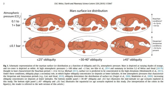
(*)The paper looks for a specific kind of crater that probably only forms when a meteor strikes an ice sheet, and finds a fair chunk of them down in the midlatitudes and equatorial regions.
19 notes
·
View notes
Photo

2023 June 27
MAVEN's Ultraviolet Mars
Image Credit: MAVEN, Laboratory for Atmospheric and Space Physics, Univ. Colorado, NASA
Explanation: These two global views of Mars were captured at ultraviolet wavelengths, beyond the spectrum visible to human eyes. Recorded by the MAVEN spacecraft's Imaging Ultraviolet Spectrograph instrument in July 2022 (left) and January 2023, three otherwise invisible ultraviolet bands are mapped into red, green, and blue colors. That color scheme presents the Red Planet's surface features in shades of tan and green. Haze and clouds appear white or blue, while high altitude ozone takes on a dramatic purple hue. On the left, Mars' south polar ice cap is in brilliant white at the bottom but shrinking during the southern hemisphere's summer season. On the right, the northern hemisphere's polar region is seen shrouded in clouds and atmospheric ozone. Known to some as the Mars Atmosphere and Volatile EvolutioN spacecraft, MAVEN has been exploring Mars' tenuous upper atmosphere, ionosphere, and its interactions with the Sun and solar wind since 2014.
∞ Source: apod.nasa.gov/apod/ap230627.html
66 notes
·
View notes
Text
"Studies of gravity variations at Mars have revealed dense, large-scale structures hidden beneath the sediment layers of a lost ocean. The analysis, which combines models and data from multiple missions, also shows that active processes in the Martian mantle may be giving a boost to the largest volcano in the solar system, Olympus Mons. The findings have been presented this week at the Europlanet Science Congress (EPSC) in Berlin by Bart Root of Delft University of Technology (TU Delft).
Mars has many hidden structures, such as ice deposits, but the features discovered in the northern polar plains are a mystery because they are covered with a thick and smooth sediment layer believed to be deposited on the ancient seabed.
"These dense structures could be volcanic in origin or could be compacted material due to ancient impacts. There are around 20 features of varying sizes that we have identified dotted around the area surrounding the north polar cap—one of which resembles the shape of a dog," said Dr. Root. "There seems to be no trace of them at the surface. However, through gravity data, we have a tantalizing glimpse into the older history of the northern hemisphere of Mars.""
continue reading
#sun#solar energy#mars#mars atmosphere#water#water on mars#oceans#oceans on mars#history#ancient history#evolution#mars mantle#sediment#solar system#life on mars#astronomy#astrobiology#cosmos
2 notes
·
View notes
Text

A rough map of Potwória, the planet of monsters, AKA Mars ll, a huge Earth-like exoplanet has been orbiting the star Zorza somewhere in the Python Galaxy for over 2.5 billion years. Potwória, which is twice the size and mass of Earth and had 42-hour-days as well as a wide range of biomes and climates ranging from arid to temperate, is orbited by two moons, one which can be seen in the day and another which can be seen in the night. It has five major continents; West Jariloia and East Jariloia, which are both situated in the middle of the planet’s tropical equator, are home to sprawling grasslands, oak forests and a vast desert interior, and are both separated from each other by a great inland sea, Tataria, a grassland-dominated island continent that is connected to East Jariloia via a land bridge, and the polar ice-capped and largely-forested continents of temperate Gniazdoia to the north and tropical Kruszwicaia to the south. There are also a few major islands and island chains that are situated in the oceans close to where the continents stand.
Jariloia, Tataria, Gniazdoia and Kruszwica all originated from the breakup of the three original continents of Czechia, Lechia and Rusia that emerged about 250 million years ago in the planet’s geological history and the subsequent break-ups and collisions of their successor continents that formed some of Potwória’s greatest mountain ranges.
For over 2.5 billion years, Potwória’s unique flora and fauna that have successfully endured mass-extinctions ranging from plate tectonics and volcanic eruptions to asteroid impacts and drastic changes in the planet’s climate. Now over the past 20 million years, the planet has been recovering from an ice age that led to a significant drop in sea-levels and the formation of land-bridges that allowed fauna from one continent to arrive and displace the fauna of another.
The first spacefaring humans from Earth’s solar system to explore and settle the giant exoplanet that orbits Zorza were from an alliance of Slavic nations and they gave it a name from Potwór, the Polish word for “monster”. Four thousand years later, an eight-nation alliance consisting of Austria, Australia, Canada, Germany, Italy, Switzerland, the United States and the United Kingdom used satellites and probes to map out the planet that they called “Mars ll” and sent in another group of humans called the “Corps of Discovery” to explore its continents, islands and oceans find out more about its climate, geography, geology, flora and fauna.
#speculative#speculative worldbuilding#speculative biology#speculative fiction#speculative evolution#speculative ecology#speculative zoology#science fiction#world building#seed world
6 notes
·
View notes
Text
The Roswell Incident

The Roswell incident, which occurred in July 1947, remains one of the most renowned UFO events. The main evidence includes initial reports of a "flying disc" recovered by the Roswell Army Air Field, which was later retracted and explained as a weather balloon from Project Mogul.
Several intriguing connections have been drawn between the Roswell incident, ancient Egypt, and Mars. For example, the unusual symbols found on the supposed remains of the UFO crashed in Roswell resemble hieroglyphs found in the Great Pyramid of Giza, leading to speculation about potential extraterrestrial influence in ancient Egypt. Furthermore, similarities between Mars and Earth, such as rocky surfaces and polar ice caps, have sparked theories about ancient civilizations on Mars and their possible connections to Earth and extraterrestrial visitors.
#history#science#ufology#aliens#religions#space#news#writers on tumblr#conspiracies#conspiracy theories#forbidden knowledge#truth reading#truthrevealed#reading#blog#writeblr#writing#writerscommunity
3 notes
·
View notes
Note
Did you know that Neptune has a moon named Larissa that orbits the planet that was first photographed in 1989 on June 1st?
Did you know that Halley is a comet that orbits the sun and can be seen twice in one persons life time from earth with the naked eye? Halley was first photographed March 14th 1986
Did you know planet mars has two moons Phobos and Deimos. Mars also has polar ice caps and is said to have seasons as well but the a twice as long as the seasons on earth? Romans stated that Mars is also said to link to Aries the god of war
I did not know any of these fun facts but I found a way to relate Taylor’s swift and Billie Eilish to them and now they feel even more fun.
Larissa’s kinda a funny name for a moon, don’t you think? How odd.
5 notes
·
View notes
Text

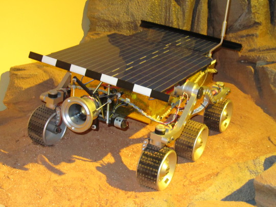
Red Planet Day
Earth dwellers have been fascinated by our next door neighboring planet for many generations. And the NASA space program has been seeking to explore and learn more about it for many decades. This so-called red planet appears in the sky as a slightly red color due to its rusty iron on the surface.
History of Red Planet Day
Red Planet Day is celebrated on November 28 as it commemorates the launch of the Spacecraft Mariner 4 by NASA in 1964, which was the first craft to ever reach Mars. It took almost eight full months for the craft to reach the red planet, finally performing a fly-by on July 14, 1965.
The Mariner 4 spacecraft was designed to gain information in fly-by mode that allowed for planetary exploration and closeup scientific observations of the planet Mars, then transmitting the information back to humans on Earth.
Many things have been learned about Mars in the years since the space program has been able to gather information. For instance, it is now understood that, like Earth, the Red Planet has a terrain that is varied, including canyons, volcanoes, deserts, polar ice caps and seasons.
How to Celebrate Red Planet Day
Have fun celebrating Mars on Red Planet Day by including some of these ideas:
Host a Red Planet Day Party
Grab some friends who are also excited about the solar system and throw a Red Planet Day Party! This could be something for school children who are interested in learning more about the planets, or an adult party that has a space theme. Invite guests to wear NASA themed costumes and serve snacks, like cookies decorated as the different planets or the moon.
For a grown-up party, consider serving some fun space-themed beverages, such as The Cosmonaut, Space Cowboy, Mars Explosion, Lost in Space Martini or the Martian Sunrise Cocktail.
Learn Fun Facts About Mars
Red Planet Day is the perfect time to enjoy learning more and gaining information about this neighboring planet. Gaining bits of trivia is a fun way to share with friends, family or coworkers and use it to raise awareness for the day. For instance, Mars is only about 1/2 the size of Earth!
Get started with some of these fun facts about the Red Planet:
Galileo Galilei was the first person to view Mars by using a telescope. The name of the planet came from the Roman god, which is related to its red appearance.
Mars has weather that is made up of extreme temperatures and, being further away from the Sun, it is generally colder than Earth. Temps can range from -191 degrees F to +81 degrees F.
The gravity on the Red Planet is roughly 1/3 of that of planet Earth. This means that a person who weighed 100 pounds on Earth would only weigh about 38 pounds due to the difference in the pull of gravity.
Because it is further away from the Sun, it takes Mars a lot longer to make its orbit. A ‘year’ on Mars would take around 687 days, which is almost twice the length of a year on Earth.
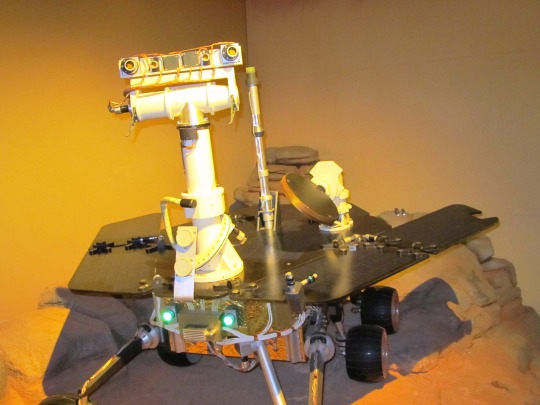
Source
#Red Planet Day#RedPlanetDay#28 November#Verkehrshaus der Schweiz#Luzern#Lucerne#Swiss Transport Museum#Swiss Museum of Transport#Schweiz#Switzerland#original photography#replica#technology#engineering#tourist attraction#Halle Luft- und Raumfahrt#NASA#Mars-Rover
4 notes
·
View notes
Text

Summer Sand Dunes
Mars’ permanent north polar cap is ringed by sand dunes. In the winter and spring the dunes are covered by a seasonal cap of dry ice.
Here, we see the dark dunes in the summer, bare of seasonal frost. Two classic barchan dunes march across the rugged terrain. The long dark dune is crossing transverse aeolian ridges probably formed in a previous climate regime. (Enhanced color cutout is less than 1 km across.)
ID: ESP_044088_2640
date: 22 December 2015
altitude: 316 km
NASA/JPL-Caltech/University of Arizona
56 notes
·
View notes
Text
CAN HUMANS SURVIVE ON MARS??
Blog#367
Wednesday, January 17th, 2024.
Welcome back,
As Earth's closest neighbors in the solar system, Mars and Venus have been objects of fascination for centuries. With the advent of space exploration and growing concerns about Earth's sustainability, the idea of human habitation on these planets is becoming less science fiction and more a potential future reality. Could we, as a species, survive on Mars?
To answer this question, we must understand the distinct challenges and potential solutions that each planet presents.
Mars, often called the Red Planet due to its reddish appearance from iron oxide (rust) on its surface, is the most Earth-like planet in our solar system.
It has a 24.5-hour day, polar ice caps, seasons, and a variety of geographical features similar to Earth's. NASA's Mars rovers, including the recent Perseverance, have found evidence of ancient water flows, leading to speculation that Mars could once have supported life.
Despite these similarities, Mars poses significant challenges for human survival. Its thin atmosphere, primarily composed of carbon dioxide, offers little protection from solar radiation.
Mars' surface temperature varies widely, with summer days at the equator reaching a comfortable 20°C (70°F), but dropping to a frigid -73°C (-100°F) at night. The planet's low atmospheric pressure (less than 1% of Earth's) makes liquid water unstable at the surface.
To live on Mars, we would need technology to protect us from radiation, supply breathable air, and provide warmth. Scientists and engineers are exploring solutions such as building habitats underground or using Martian soil to shield against radiation.
To generate oxygen, NASA's Perseverance rover carried an experiment called MOXIE (Mars Oxygen In-Situ Resource Utilization Experiment) that successfully produced oxygen from Mars' carbon dioxide-rich atmosphere. Life support systems could potentially extract water from ice at Mars' poles or in the ground.
Originally published www.miragenews.com
COMING UP!!
(Saturday, January 20th, 2024)
"WHY ARE THE BLACK HOLES INVISIBLE??"
#astronomy#outer space#alternate universe#astrophysics#universe#spacecraft#white universe#space#parallel universe#astrophotography#moon mars#mars
57 notes
·
View notes
Text
Beneath Shared Skies
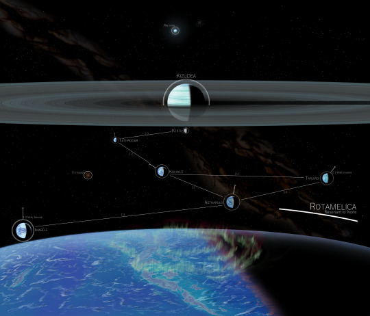
A painting I commissioned from my friend @thefallencomet depicting a planetary system of my own design.
Alt text in full: [From top to bottom, eight worlds: a planet and its moons. The planet is the cyan gas giant Kizudea, surrounded by its extremely wide rings (which stretch across the entire width of the image and then some). Directly below Kizudea is the steppe moon Kertil, which is dusty orange with purple plants and small bright blue seas. To the left of Kertil is the pelagic moon Tathrodar, which has small green islands as well as a notable ice cap facing directly away from the parent planet. Down and to the right of Tathrodar is tilted Kolayut, which has varied land colors including green, purple, and desertic orange as well as a notably off-kilter appearance due to its extreme axial tilt (producing a north polar cap almost diagonal off the vertical and, due to seasonal effects, icy midlatitudes). Far to the right is the grand moon Taruvidi, heaviest of all the moons, with turquoise oceans and both green and purple photosynthesisis evident on its surface. To the left of Taruvidi is Astharulo, with one green-coasted and desert-hearted supercontinent facing the shot. At far left is icy Imarele, with two vast polar caps as well as a fragmented "outer" cap and several dusty lifeless landmasses. All the moons are cloudy, with storms evident on the surface of some of them. All bodies are roughly in gibbous phase, with the orange parent star Shumatila far off beyond the right side of the image; though the effects of bluer Rhetiffa (near the top of the shot, and visibly oblate despite its small size in the image) provide some lighting on Rotamelica and the rings. There is a galactic dust lane and many background stars visible in the image, plus the local red star Yctrugar and a distant globular cluster. The image is labeled]
Notes:
- Resonance chain: 18:12:6:4:3:2 Kertil-Tathrodar-Kolayut-Taruvidi-Astharulo-Imarele, with several additional resonances as a result of these between various pairs of moons.
- Kizudea's rings are studded with occasional shepherd moonlets, which come together and fall apart relatively often. Other asteroid moons exist within the system, in the rather few stable zones between the resonance moons and in the outer cloud (often in resonance with Rotamelica). In addition, there's Rotamelica's own asteroid submoon Behmus- a mid-sized chunk in a low off-kilter orbit around the moon wth a chaotic rotation.
- Kizudea, while not a brown dwarf, is still a very heavy gas giant- over ten Jupiter masses, in fact. It's even hotter than its relatively temperate orbital position would suggest, and puts out so much infrared light that even on faraway Rotamelica there is a notable temperature difference between apoapsis- on the tidelocked resonance moons, this increased heat on the subplanetary side can manifest in the presence of a cold antiplanetary outer ice cap in addition to the north and south ice caps.
- Kertil's seas come in three types: great lakes, which are shallow but cover very large areas (compare Lake Victoria); trenches, which are very deep but small (compare Lake Tanganyika); and basins, which consist of a great lake joined to a trench and can sequester much of the water of an entire hemisphere (...imagine if the Mediterranean was closed, and on Mars?). Kertil is warm and its relatively thick atmosphere mediates the temperature better than a thinner one would, but it still experiences telltale extra precipitation where an outward cap would be on a colder planet.
- Tathrodar has the most ocean coverage of any moon in the system, but it's also the smallest of the ocean moons (it and Kertil put together are still less massive than any of the other large moons). This and its thin atmosphere conspire to create a prominent outer ice cap. Life on Tathrodar's few islands is expected to have arisen from a panspermia event, though from which moon said life came from is still unclear.
- Kolayut's tilt is not its only odd property, but it explains a lot of them (including its relatively temperate equator). Kolayut has multiple colors of photosynthesis on its surface- in fact, the moon is suspected to have a grand total of four different origins for its life- green photosynthesizers came from Astharulo, purple from Kolayut itself, blue-purple from Rotamelica, and yellow-green possibly from Tathrodar. It also has the highest gravity of any of the moons, owing to its high mass and relatively small radius. Finally, Kolayut has the highest atmospheric pressure of any moon and reaches the highest average temperature.
- Taruvidi is the most massive and largest moon, edging out Rotamelica by a dozen kilometres. It's heavier than most of the other moons put together (excluding Rotamelica and Kolayut), and has a high concentration of helium in its atmosphere. While Taruvidi has multiple photosynthesis colors like Kolayut, both are suspected to have evolved on Taruvidi.
- Astharulo's more tectonically active than it might seem. While nearly all land on its surface is currently arranged into the two supercontinents, each is composed of a mess of smaller plates all grinding against each other- and this activity (and its slightly-low gravity) mean that its mountains are the tallest from sea level in the moon system, with several peaks beating out Kertil's highest shield volcanoes. The supercontinent on the outer hemisphere of the planet is slightly biased towards the north, while the inner-hemisphere one is predominantly southern- they are not antipodal, but notably close to it.
- Imarele has the lowest concentrations of carbon dioxide in the system, owing to plant life that evidently consumed its relatively deficient original supply. As a result of this, its thin atmosphere, and its distance from Kizudea; it is by far the iciest of the moons- while a thin equatorial corridor is always open even in the coldest of times, the surface of the ocean is still rather cold. While its distance from Kizudea dampens the effect, Imarele still has notable effects of its tidelock: its outer ice cap is the most prominent of any moon, though it is fractured. Likewise, the ocean corridor is visibly wider on the planet-facing side. Dry ice would form at its poles... if it had any carbon dioxide.
- Rotamelica is the largest of Kizudea's moons outside the resonance, and even nearly has the highest radius- though its mass is ranked third. Its atmosphere contains the most noble gases of any of the moons- one of many hints of its extra-Kizudea origin. It also contains the highest concentration of carbon dioxide, and as such its greenhouse effect is rather strong. This additional heat, in addition to the rather archipelago-favoring arrangement of land on Rotamelica at present (in contrast with Taruvidi) mean hurricanes wrack its many purple-forested islands very often. Rotamelica's magnetic field also interacts oddly with that of Kizudea.
40 notes
·
View notes
Last Seen Blogs

melivingforme
The view from a sort of adult with a child

captainditrag
Captain Ditrag's Movie Reviews & Singing Videos
captainditrag
Captain Ditrag's Movie Reviews & Singing Videos

paraglidingadventuresinnepal
Paragliding Adventures in Nepal

mk4juhcob-blog
#lowandslow