#NPS Rustic Architecture
Explore tagged Tumblr posts
Visit Tumblr Blog
Explore Tumblr blogs with no restrictions, modern design and the best experience.
Last Seen Tumblr Blogs


Fun Fact
Post activity is at the highest at 4:00 pm EDT; notes peak at 10:00 pm EDT.
Text
Mount Rainier National Park Archives Photos of the Sunrise South Blockhouse (part of the stockade group) in 1930.
May is National Historic Preservation Month, when we celebrate the places that preserve a piece of our shared history. Mount Rainier National Park was designated a National Historic Landmark District in 1997 as no other park has preserved as much of an intact example of early park planning as Mount Rainier. Beginning in the late 1920s, the master plan for Mount Rainier was the first and most complete national park master plan to be developed and implemented in the National Park Service. The park was treated as a synthetic whole – not a group of fragmented locations – and this consistent design can still be seen in the buildings, roads, bridges, trails, and developed areas.

Mount Rainier National Park Archives Photo of the Paradise Inn in 1940-41.
Mount Rainier National Park is also home to five buildings that are independently designated National Historic Landmarks: the Longmire Administration Building, Longmire Community Building, Longmire Service Station, Paradise Inn, and Yakima Park Stockade Group (home to the Sunrise Visitor Center). Each of these represent unique examples of early park architecture. Have you visited all five buildings?


Mount Rainier National Park Archives Photos: Longmire Community Building circa 1927 (left) and Longmire Service Station in 1929 (right).
Learn more about the historic district at https://go.nps.gov/MountRainierHistoricDistrict
#Historic Mount Rainier#mount rainier national park#NPS Rustic Architecture#rustic architecture#National Historic Landmark#National Historic Landmark District#National Historic Preservation Month#history#historic building#Paradise Inn#Longmire
40 notes
·
View notes
Photo

On This Day: The Civilian Conservation Corps
A Conservation Legacy
The park development made possible by the CCC still plays a significant role in how today’s visitors experience park landscapes across the country.
On April 5, 1933, President Franklin D. Roosevelt issued Executive Order 6101 and the Emergency Conservation Work (ECW) officially commenced. This was the first formal name for what came to be known as the Civilian Conservation Corps (CCC). More informally, the CCC was known as “Roosevelt’s Tree Army.”

Franklin D. Roosevelt is served a meal during a visit to a CCC Camp, August 1933 (NPS Photo / Shenandoah National Park).
The legislation that formed the basis for this order was commonly called the Federal Unemployment Relief Act. Part of the New Deal, it was a response to high unemployment rates of the Great Depression. The bill outlined the provisions for ECW enrollment and wages.
As it was signed into law in late March of 1933, representatives of various agencies gathered at the White House to discuss how it would be implemented.

Enrollees from CCC Company #411 pose behind the Officers Quarters at Camp NP-5, Kephart Prong (NPS Photo / Great Smoky Mountains National Park).
Throughout the existence of the CCC (1933-1942), the program employed youths and initiated conservation measures on forest, park, and farm lands. Improvements to roads, campgrounds, and trails also provided the nation with increased recreational opportunities.
By mid-May of that year, the National Park Service was prepared to have 12,600 men employed in national parks and monuments in 63 approved camps. The work performed by the CCC included forest improvement projects, construction and maintenance of fire breaks, clearing of campgrounds and trails, survey work, plant eradication, bridge building, campground construction, and road building.

Hillside Spring retaining wall and basin, built by the CCC in 1935 (NPS Photo / Chickasaw National Recreation Area).
By the time the CCC was ended, a total of around two million enrollees had performed work in 94 national parks and monuments. The park development made possible by the CCC still plays a significant role in how today’s visitors experience park landscapes across the country.

Rainbow Bridge, near the summit of Halemau'u Trail in the CCC Haleakalā Crater Trails District of Hawaii, is a spectacular natural feature improved by the CCC (NPS Photo).
Discover More
Source: Paige, John. Civilian Conservation Corps and the National Park Service, 1933-1942: An Administrative History. National Park Service, 1985.
Celebrating FDR’s Conservation Legacy
Roosevelt’s Tree Army: The Civilian Conservation Corps - Digital Public Library of America
The Living New Deal: Find New Deal projects, including CCC work in and beyond national parks. The New Deal map can be filtered by agency and category.
NPS Rustic Architecture and Roosevelt’s Emergency Programs
National Parks and Cultural Landscapes
Civilian Conservation Corps - Theodore Roosevelt National Park
CCC Oral Histories - Shenandoah National Park
Civilian Conservation Corps - Ozark National Scenic Riverways
CCC Haleakalā Crater Trails District in Haleakalā National Park
Cultural Landscapes of Chickasaw National Recreation Area
#OTD#National Park Service#Cultural Landscape#History#CCC#Civilian Conservation Corps#Landscape History#NPS#Landscape Architecture#Rustic#New Deal#Conservation
61 notes
·
View notes
Photo

Logan Pass Visitor Center
If you’ve visited Glacier in the summer, it’s likely you made a stop at the Logan Pass Visitor Center as you drove over the Going-to-the-Sun Road. That building, which opened in 1967, wasn’t the first building at Logan Pass, however.
The George Grant photo shown above, taken July 12, 1933, shows the rustic stone comfort station, opened in 1932, that preceded today’s visitor center. The men in this photo are clearing snow from the parking lot in preparation for the Going-to-the-Sun Road dedication ceremony on July 15, 1933. Back then, the parking lot had a number of irregularly shaped islands around which cars would park. When the new visitor center was built in the 1960s, the parking lot was redesigned and expanded to provide more parking spaces. The photo below shows the comfort station in 1952.

Construction of the new visitor center was part of the Mission 66 movement, a program initiated in conjunction with the 50th anniversary of the National Park system that sought to expand visitor services through infrastructure improvements. The new building’s design was a departure from the traditional rustic style “Parkitecture” favored by the NPS in the 1920s and 1930s. Instead, the Mission 66 style reflected modern post-World War II architectural theory that emphasized open interiors and the use of natural materials to blend the building into its adjacent landscape. The photo below shows the new visitor center in 2016, on the National Park Service’s 100th anniversary.

You can read more about the influence of Mission 66 in Glacier here: https://www.nps.gov/glac/learn/historyculture/mission-66.htm
[Top image: A black-and-white photo shows a stone building in front of a mountain. Several men in the foreground clear snow from an unpaved parking lot. Middle image: The same stone building is shown in front of the same mountain, in color this time. In the foreground, several cars are parked in the unpaved parking lot. Bottom image: Color photo showing the new visitor center in front of the same mountain from the first two photos. The building features a sloped roof and stone facade. People walk along pathways leading to the building. Two flag poles fly the flags of Canada and the United States.]
#history#glaciernps#glacier national park#logan pass#tbt#historical photo#mission 66#visitor center#throwback thursday
23 notes
·
View notes
Photo

Daily Waypoint | N 43º 39′ 33.5″ W 110º 42′ 44.2″ Menor's Ferry NPS Lock—Menor's Ferry was a river ferry that crossed the Snake River near present-day Moose, Wyoming. The site was homesteaded by Bill Menor in 1892-94, choosing a location where the river flowed in a single channel, rather than the braided stream that characterizes its course in most of Jackson Hole. Menor's homestead included a five-room cabin, a barn, a store, sheds and an icehouse. Menor operated the ferry until 1918, selling to Maude Noble, who continued operations until 1927, when a bridge was built at Moose. The Menor house and store are unusual in their application of classical forms to rustic log construction, an effect heightened by the whitewashed walls of the buildings. The Menor cabin has three rooms, with a bedroom on the west, a store on the east, and a kitchen and storage room connecting them. The Menor cabin was the point of departure for the first ascent of Grand Teton on August 11, 1898, and it hosted the celebratory party that evening. https://www.fmgphoto.com/Lifestyle/Architecture/i-NSQfJdX https://followingmygps.com/menors-ferry/ #lock #doorlock #MenorsFerry #MenorsFerryGeneralStore #Moose #Wyoming #GrandTetonNationalPark #NationalPark #Menorcabin #SnakeRiver #JacksonHole #cabin #rustic #Architecture #building #DailyWaypoint #dailyphoto #travelphotography #fmgphoto #followingmygps #fmg #fmgbear #photography #travel #lifestyle #LifeWellLived #travelmagazine #roadtripping #exploring #roadtrip (at Menor's Ferry) https://www.instagram.com/p/B9HPJJvhbZn/?igshid=1xf2awswdxnom
#lock#doorlock#menorsferry#menorsferrygeneralstore#moose#wyoming#grandtetonnationalpark#nationalpark#menorcabin#snakeriver#jacksonhole#cabin#rustic#architecture#building#dailywaypoint#dailyphoto#travelphotography#fmgphoto#followingmygps#fmg#fmgbear#photography#travel#lifestyle#lifewelllived#travelmagazine#roadtripping#exploring#roadtrip
0 notes
Text
Grand Canyon National Park
Grand Canyon National Park
Grand Canyon, Arizona
Tuesday, June 12, 2018
Clear, 95°
“The wonders of the Grand Canyon cannot be adequately represented in symbols of speech, nor by speech itself. The resources of the graphic art are taxed beyond their powers in attempting to portray its features. Language and illustration combined must fail.” - John Wesley Powell
After the little hike at Horseshoe Bend it was only a couple hours’ drive to The Grand Canyon. The Grand Canyon is a steep-sided canyon carved by the Colorado River in Arizona. Words like Grand, Massive, Oh Wow, and Impressive cannot truly describe The Grand Canyon. Its massive size overwhelms the senses. It is 277 miles long, up to 18 miles wide and attains a depth of over a mile (6,093 feet).
Grand Canyon Sign
The canyon and adjacent rim are contained within Grand Canyon National Park, the Kaibab National Forest, Grand Canyon-Parashant National Monument, the Hualapai Indian Reservation, the Havasupai Indian Reservation and the Navajo Nation. President Theodore Roosevelt was a major proponent of preservation of the Grand Canyon area, and visited it on numerous occasions to hunt and enjoy the scenery.
Distant Canyons
Nearly two billion years of Earth's geological history have been exposed as the Colorado River and its tributaries cut their channels through layer after layer of rock while the Colorado Plateau was uplifted. While some aspects about the history of incision of the canyon are debated by geologists, several recent studies support the hypothesis that the Colorado River established its course through the area about 5 to 6 million years ago (*Wikipedia)
Grand Canyon
On the South Rim side of the Park, there is no need to drive around in traffic. Park your car or RV and ride the free shuttle buses around the village and out to scenic overlooks. The drivers are funny and very helpful getting you to where you want to visit and offer great hints to get more out of your visit. I am not sure what the North Rim has for services but know it is higher in elevation and more remote.
Grand Canyon toward East
Coming in from Page, Arizona through the east gate, the first stop on the eastern end of the South Rim is the Desert View Watchtower, built in 1932. It is one of Mary Colter's best-known works. It is 27 miles from Grand Canyon Village; the tower stands 70 feet tall.
Desert View Watchtower
The top of the tower is 7,522 feet above sea level, the highest point on the South Rim. It offers one of the few full views of the bottom of the canyon and the Colorado River.
Colorado River Below
It was designed to mimic Anasazi watch towers, though, with four levels; it is significantly taller than historical towers.
Desert View Watchtower interior
Mary Colter (April 4, 1869 – January 8, 1958) was an American architect and designer. She was one of the very few female American architects in her day. She was the designer of many landmark buildings and spaces for the Fred Harvey Company and the Santa Fe Railroad, notably in Grand Canyon National Park. Her work had enormous influence as she helped to create a style, blending Spanish Colonial Revival and Mission Revival architecture with Native American motifs and Rustic elements; that became popular throughout the Southwest. (*Wikipedia)
Plaque on top of Tower
Desert View Watchtower gives you another “Oh Wow” moment with the full view of the Canyon below. As you look out for miles on end, the Canyon is before you to the west and the high plains of the Colorado Plateau are toward the east. The vibrant colors of the Canyon, even in mid-day, gives a depth and saturation only dimmed by the slight smoke of the forest fires in Colorado several hundred miles away.
Colorado Plateau
There were a couple of Navajo vendors inside the Tower who were giving cultural information while making their crafts. They were doing wood and stone carvings with several work stations set up for visitors to watch them work. Both were very informative and answered questions while they worked.
Grand Canyon - Another Oh Wow Moment
Driving the twenty five miles along the South Rim to the Grand Canyon Village, there are multiple places (overlooks) to stop for views and photo opportunities of the Canyon below. At each pull out, several vehicles made a daisy chain caravan stopping for photos. It was slightly funny to watch everyone get out, look for a couple minutes, snap a few pictures and head out to the next one. This went on for the whole twenty five miles to the Village.
North Rim Horizon
Approaching the Village, it suddenly got really crowded as the Parks Service had quite a bit of road construction going on. Several roads were being repaved so crews were directing traffic into single lane passes as the crews stripped the old pavement and filled in so the new surface could be poured and smoothed out. Like most Government projects there were quite a few workers with many standing around, several operating heavy equipment, and several supervisors talking to each other. It will probably be a long summer of work . . . maybe with the high temperatures and tourists all over the place it would be a great idea to work night shifts. More work could be done with less people driving by, there would be cooler temperatures to work in, and you would be a little more productive in the process by getting more miles of pavement put down. Oh well, that would be too easy, just an observation from years of construction projects. (Rant over)
Getting to the Village Campground, finding a place to park, and waiting in line to talk with the Camp Registration office, it was slowly learned that I had not booked at that campsite. With a little digging in the Parks computer system and me looking at emails from March it was discovered that when looking to book, everything was full and I had booked just off site at a campground with a similar name. It was about this time that I really felt like an idiot but the lady assured me that it happens almost every day.
It was time to get back in the RV, turn around, hit traffic again and find the way to the Park entrance and drive a mile down the road to the new campground. This one was expecting me so check-in went smoothly and it was time to set up for another night in paradise.
As I was setting up the RV for the night I could hear that familiar “Whup, whup” sound of helicopters flying about. The campsite was along the return path of flight seeing helicopters on their way back to the airport about a half mile away. They must be doing a great business as there were choppers returning to the airport in sets of six or eight returning about the same time with the process repeating about every twenty minutes or so all afternoon. The campground had two elk that grazed across from the RV and five to ten more were further back in the campground. I believe they live there and stay in the area as several people said they were there every morning and afternoon eating till the sun went down.
It was about six hundred feet to walk to the shuttle bus stop outside the campgrounds so it was easy to make our way back to the park to view the sunset. The bus driver, Trey, was entertaining and talked about the smoke in the Canyons today. He said he had property in Durango, Colorado and knew all about that fire. It was started by the narrow gauge railroad that operates in the area and that the fire was still not close to being contained. He chatted with an Asian family who was also on the bus. He gave specific directions once getting off the bus on the fastest way to get to the Canyon rim for the best photo shots in the area.
The sun was just setting, giving an orange glow to the western horizon. The walls of the Canyon to the east were highlighted by the Alpenglow of the sun and gave nice details between light and shadow on the cliff face.
Afternoon Sun
There were several overlooks in this area around the Village and all were full of people snapping photos of every cliff and overlook.
Afternoon Vistas
At one glance I could see about forty phone screens illuminated, held high taking photos or selfies on one ledge overlook.
Sunset 1
It was kind of humorous seeing everyone running around trying the get that great shot of the sunset or the Canyon walls all aglow. You could hear the quiet voices of many different languages talking, a true international gathering of people celebrating the same thing, a beautiful sunset.
Sunset 2
Everyone stopped in awe of another day’s passing into night, shadows, and darkness.
Sunset 3
The bus driver also told us about the Grand Canyon Star Party that is held each year in June. Due to its dark skies and clean air, Grand Canyon offers one of the best night sky observing sites in the United States.
Evening Star
Grand Canyon Star Party
For eight days in June, park visitors explore the wonders of the night sky on Grand Canyon National Park's South Rim with the Tucson Amateur Astronomy Association and with the Saguaro Astronomy Club of Phoenix on the North Rim. Amateur astronomers from across the country volunteer their expertise and offer free nightly astronomy programs and telescope viewing. Through the telescopes you might view an assortment of planets, double stars, star clusters, nebulae and distant galaxies by night, and perhaps the Sun or Venus by day. At the 2018 Star Party, Jupiter and Saturn will be evening highlights, but you might find an astronomer pointing a telescope at Venus in the early evening. Mars will rise just after 11 pm for those staying late in to the evening. (NPS information)
There were between fifty and seventy-five telescopes set up in the rear parking lot of the Village Visitors Center for the public to view the heavens once darkness set in. As the sun’s glow on the horizon was quickly diminishing the planets and stars were appearing across the night sky. Most telescopes were set up to view Venus and Jupiter as those were visible as soon as darkness set in. It was great seeing Jupiter and four of its moons so clearly through several telescopes.
We waited for this one man to set up his eight or nine foot tall telescope so we could view whatever he was going to point too. It was funny because he had trouble locating the North Star so he could calibrate his telescope but I and another by-stander showed him where it was. He spent about twenty minutes zeroing in his instrument before he was ready to view the stars. When he was finally locked on to his target it was a star nebulae cluster. It was beautiful, having the appearance of something like the Milky Way. You had to climb up on a ladder to get a view through the lens of his telescope.
It was a beautiful high desert evening, cooling off nicely once the sun dropped below the horizon. It probably dropped 10 degrees in about thirty minutes or so. The bus driver reminded everyone that the last shuttle from the Visitors Center left at 9:30 so stargazing had to be put on hold but it was hard to leave then as the stars were just beginning to pop out all over the heavens.
Walking across the parking lot where all the telescopes were set up, looking west there was a sudden burst of exhilaration from the crowd as a shooting star appeared to the right and fell in a beautiful greenish arc across the sky to the left. It was if the astronomers had ordered this beautiful light show. The crowd continued in an excited state for several minutes hoping another one would fall.
Taking the shuttle bus back, we had the same driver, Trey. Two young men (boys really) about twenty years old started to get onto the bus toting their bicycles. Trey said to them loud enough for anyone on the bus to hear, “Does it say anywhere that bicycles are allowed “In” the bus?” They stepped back off and started to go to the rear of the bus when he called out again to them, “I’ll give you a hint, not that way guys!” They stopped, turned around and went to front of the bus where a large bike rack was attached to the bumper. The boys, looked at it, looked at each other puzzled wondering how to attach their bicycles. Trey got off the bus and happily showed them how to operate the simple hold downs for quick loading and unloading of the bikes.
As he spoke about bicycles being allowed “In” the bus, this Hindu family just cracked up and was excitedly talking back and forth while the bicycles were loaded on board. As the two young men entered the bus, the family continued talking excitedly; they seemed amused that the boys were finally able to get on. Their son who was about nine or ten started asking Trey all kinds of questions about the Park, the Canyon, many types of animals and more. Trey told the mom and dad they needed to get this young boy some books as he “had wheels and was going somewhere with his life!” He asked the boy why he knew so much about the Grand Canyon and the area. The little boy answered, “I Googled it!”
A little comedy, beautiful sunset, the Heavens opening up with stars, and seeing a meteor fall close by, made for a very memorable day Traveling Life’s Highways.
#Grand Canyon National Park#Grand Canyon#America#America the Beautiful#Beautiful Places#Grand View Watchtower#Interesting things#Interesting places#Travel#Traveling Life's Highways#Road Trip#RV'ing#Veterans
0 notes
Photo


The picnic shelter in the Longmire Stewardship Campground is complete!
Craftsmen in Mount Rainier’s carpenter shop, under the leadership of Mitch Anderson, have been working on this project for two years now, in between other projects. With much of the rest of the park inaccessible in the winter, this is a perfect season for such work, and the final roof boards were laid earlier this week.
As you can see in these photos, though, this is not just a slap-dash 2x4 frame shelter. Our crew built the shelter in a manner that mimics the historic “NPS Rustic” architectural style found throughout the Longmire Historic District, including the campground. It uses massive wood beams, carefully carved to fit tightly together without need for steel bolts.
The shelter is large enough to accommodate several picnic tables, and is located in the middle of the campground -- at the north end of the tent sites, just south of the residential RV sites (where employees live during the summer), adjacent to the middle bathroom, and around the corner from the community fire ring and our primary group campsite. Water and electric are accessible from the RV site immediately next to the shelter.
The shelter was constructed, in large part, with funds donated through Washington’s National Park Fund, yet another example of the tremendous value we get from that partnership. It will be used by groups ranging from schools and colleges visiting for education programs, to tribal groups using the nearby Tribal Use Area in wet weather, to youth crews conducting training, to volunteer groups like Starbucks employees and Mount Rainier National Park Associates teams gathering after a work day on the trail.
We look forward to using this beautiful new addition to our program this spring!
0 notes
Text
Hyperallergic: A Fallen Brooklyn Elm Shaped into Objects That Reflect on Immigration
Installation view of Witness Tree Project at the Lefferts Historic House in Prospect Park (photo by the author for Hyperallergic)
Some old trees meet an undignified end in a wood chipper, yet since 2009 the Witness Tree Project has transformed historic arbors into design objects. The collaborative project between the Rhode Island School of Design (RISD) and the National Park Service (NPS) involves students who use wood from trees that have “witnessed” US history, crafting pieces inspired by that heritage.
Kara Fan, “Altar” from The Witness Tree Project (courtesy the artist and RISD)
“In the first year of the project, we worked with a 150-year-old pecan from the Hampton National Historic Site, an 18th-century plantation outside of Baltimore, Maryland,” Daniel Cavicchi, associate provost for Research|Global|Practice at RISD, told Hyperallergic. “We didn’t know what to expect, but quickly realized the potential of aligning liberal arts and studio learning.”
In following years, they worked with the Olmsted Center for Landscape Preservation to identify fallen trees on national historic sites, and focused courses on the presidential homesteads of the Roosevelts and Martin Van Buren, as well as Thomas Edison’s factories and Frederick Law Olmsted’s design office. “Each year is similar in structure, but the topic is completely different,” Cavicchi explained. “Part of the fun, for me, is conceiving of the overarching seminar theme, which depends on what a given tree may have witnessed.”
This year’s iteration, presented with the Prospect Park Alliance, is now on view at the Lefferts Historic House in Brooklyn’s Prospect Park. Cavicchi taught a course with RISD Senior Critic of Furniture Design Dale Broholm entitled “The Politics of Belonging: Race, Diversity and the Immigrant Experience in Brooklyn and Beyond,” through which students crafted design objects reflecting on immigration. The resulting pieces range from a wooden turntable by Isabel Andrews inspired by the mixing of African American, Caribbean, and Latino influences in hip-hop, to wooden kaleidoscopes by Danny Icaza that remix the text of Trump’s travel ban. All of their material was sourced from an over 150-year-old fallen elm that once stood at the Prospect Park Parade Ground.
Before students used the harvested wood, it was cut and dried by the Brooklyn-based RE-CO BKLYN. “Witness trees” are designated by NPS, and those involved into the project have fallen due to age, weather, disease, or other ecological trauma. As Prospect Park is marking its 150th anniversary, the elm had witnessed the evolution of the area over the years, from Dutch farm villages to Caribbean communities, but always enduring as a home for immigrants. The RISD students come from across disciplines, from architecture to textiles, so they also brought a diverse approach to woodworking in their pieces.
Installation view of Witness Tree Project at the Lefferts Historic House in Prospect Park (photo by the author for Hyperallergic)
“Overall, the circumstance of working with the actual material of a historic tree is a powerful means for understanding the past,” Cavicchi said. “Students learn not only about the events radiating from a tree’s location — the rise of slave labor in antebellum America, for example, or Theodore Roosevelt’s reshaping of presidential power — but also about how a given tree poses questions of interpretation. To what extent can a tree serve as material evidence for American history? How might one assess the significance of place in historical thought?”
Stephanie Tan, “Stool” from The Witness Tree Project (courtesy the artist and RISD)
The finished objects from the Prospect Park elm are all gathered in one period room of the Lefferts Historic House, itself a structure built by a Dutch family in the 18th century. The warm light from the windows gives each wooden form a soft glow, with Kara Fan’s “Altar Table for the First-Generation” inspired by Chinese home altars in a corner, and Andrew Nota’s rifle installed over the fireplace, its slim wooden body inspired by the M1903 used in the two world wars, carried by soldiers both born in the US and who immigrated here. Many of the objects consider the changing meaning of home for immigrants. Brian Skalaski made a series of pieces on Polish identity, including a kitchen table that responds to the shift from farming communities to American life; one side is rustic and dark and balances a plate, the other is lighter and is topped with a worker’s lunchbox. Some students embraced the wavy, warped quality of the weathered wood, such as Stephanie Tan, who used its qualities in an elm stool, representing a traditional Chinese design, while exploring what “Chinese culture” means post-Mao and having absorbed Western influence.
“When I first heard that New York City Parks had one of the original elms from the Prospect Park Parade Ground, one thing that immediately came to mind was the role of the Park in the rich social history of Brooklyn,” Cavicchi stated. “In the late 19th century, nearly half of Brooklyn’s population over 20 years of age was foreign-born, and Prospect Park served as a common site for diverse kinds of leisure, gathering, and ritual. Today, Brooklyn is the most densely populated of New York City’s five boroughs, home to many new generations of immigrant groups, and Prospect Park remains a rich lens for study the dynamics of social identity in public space.”
Isabel Andrews, “Strung Bowl” from The Witness Tree Project (courtesy the artist and RISD)
Installation view of Witness Tree Project at the Lefferts Historic House in Prospect Park (photo by the author for Hyperallergic)
From left to right: Katie Flood’s “Cuban Diaspora”; Danny Icaza’s “HABIT-TUAL” (photo by the author for Hyperallergic)
Daniel Icaza Milson, “Kaleidoscope” from The Witness Tree Project (courtesy the artist and RISD)
Installation view of Isabel Andrews’s “Brooklyn Game Board” at the Lefferts Historic House in Prospect Park (photo by the author for Hyperallergic)
From left to right: Kara fan’s “FATAKE OUT”; Brian Skalaski’s “Untitled” (workbench); Andrew Nota’s “Untitled” (rifle) (photo by the author for Hyperallergic)
Katie Flood, “Water Yoke and Buckets” from The Witness Tree Project (courtesy the artist and RISD)
Installation view of Talia Conelly’s “Code Switching” Rubik’s Cube and Isabel Andrews’s “Turntable” at the Lefferts Historic House in Prospect Park (photo by the author for Hyperallergic)
The Lefferts Historic House in Prospect Park (photo by the author for Hyperallergic)
Witness Tree Project continues through September 30 at the Lefferts Historic House (452 Flatbush Avenue, Prospect Park, Brooklyn).
The post A Fallen Brooklyn Elm Shaped into Objects That Reflect on Immigration appeared first on Hyperallergic.
from Hyperallergic http://ift.tt/2x92yDC via IFTTT
0 notes
Text
6 Iconic Grand Canyon Buildings Designed by Mary Colter
The Grand Canyon’s South Rim is peppered with unique and visionary structures designed by pioneering architect Mary Colter.
Mary Colter was part of a small handful of female architects working in the early 20th century. In fact, census data indicates that there were only 22 female architects in the United States when Mary Colter graduated from the California School of Design (now the San Francisco Art Institute) and began her apprenticeship at a local architectural firm!
During her 38 years as the chief architect for the Fred Harvey Company, Mary Colter designed 21 landmark hotels, lodges, and public spaces, many of which are now located within the boundaries of the Grand Canyon National Park at the South Rim.
Image Source: Grand Canyon National Park
Known for her perfectionism and bold vision, Mary Colter was one of the first American architects to give her buildings a site-specific sense of place. In this style, Colter’s well-loved Grand Canyon structures blend a number of architectural themes, such as Spanish Colonial Revival and Mission Revival styles, with Native American motifs and other rustic elements like using native stone. Her buildings are perfectly at home on the edge of the Grand Canyon, reflecting the unique history and geography of their location. Make sure you check out these classic Grand Canyon spots when you visit the South Rim:
1. Hopi House (1904)
When the Fred Harvey Company noticed that native American craftspeople were doing a booming trade selling their arts and crafts at railroad stops, they began planning Hopi House, a dedicated marketplace for native American wares on the South Rim.
Image Source: Grand Canyon National Park
Located next to El Tovar Hotel, Hopi House is a prime example of Colter’s unique site-specific style. The building was built by Hopi craftsmen and constructed using local materials and salvaged items, such as Civil War-era Western Union telegraph poles and rails.
For many Grand Canyon visitors, Hopi House was their first introduction to Hopi and Native American culture, and to this day, Hopi House still operates as a native American gift shop.
2. Hermit’s Rest (1914)
Hermit’s Rest was built in 1914 as a rest area for tourists travelling on coaches operated by (you guessed it!) the Fred Harvey Company on their way to what was once Hermit Camp.
Image Source: Grand Canyon National Park
This simple log-and-stone building was designed to look like a rustic getaway that Louis Boucher, a trail guide and infamous “hermit” who once lived in the area, would have built. With this in mind, Mary Colter actually ordered the fireplace to be intentionally streaked with soot to add an aged effect. Grand Canyon Fact: Around 1891, Louis Boucher staked claims below what is now Hermit’s Rest. With help, Boucher pioneered the Hermit Trail into the Grand Canyon.
Hermit’s Rest is located at the western end of Hermit Road and is the western terminus of the Rim Trail.
3. Lookout Studio (1914)
Situated just west of Bright Angel Lodge, Lookout Studio is one of the most prominent examples of Mary Colter’s unique style.
Image Source: Grand Canyon National Park
Colter’s design for Lookout Studio draws heavily from its natural surroundings: the native stone exterior and multi-level design blend in seamlessly with the layers and edge of the Grand Canyon, while it’s asymmetrical roofline mimics the Canyon’s natural shape to create the illusion that the Studio is an extension of the Canyon’s steadfast stone walls.
Today, Lookout Studio offers multiple viewing platforms and a gift shop where Grand Canyon visitors can pick up a memento of their adventure. Grand Canyon Fact: Lookout Studio was strategically positioned on the Rim path to create a bottleneck that would slow down and distract visitors from checking out the competing Kolb Studio a few feet further along the trail.
Check out Lookout Studio on these tours:
Grand Canyon South Rim Bus Tour
Explore the Grand Canyon Village and marvel at the South Rim’s breathtaking views on our most popular guided and narrated luxury bus tour to the Grand Canyon’s South Rim National Park! RESERVE NOW
Grand Canyon South Rim Deluxe Bus & Helicopter Tour
Travel over the Hoover Dam Bypass Bridge and stop in Kingman, Arizona before your 30 minute flight over the Grand Canyon! Explore Bright Angel Lodge before you return to Las Vegas. RESERVE NOW
Grand Canyon South Rim Adventure
The South Rim offers some of the most memorable views of the Grand Canyon. Experience them for yourself in a luxury mini-coach on a South Rim adventure for all to enjoy! RESERVE NOW
4. Phantom Ranch (1922)
Mary Colter’s use of on-site fieldstone and rough-hewn wood was largely a product of necessity based on the Ranch’s remote location, but the use of native materials to construct National Park Service Structures soon became the default for NPS and Civilian Conservation Corps buildings. In fact, Mary Colter’s design for Phantom Ranch influenced an entire genre of “parkitecture”, often referred to as “National Park Service Rustic”.
Image Source: Grand Canyon National Park
Grand Canyon Fact: The Fred Harvey Company wanted to name Phantom Ranch “Roosevelt Chalets”, but Mary Colter refused to release her plans for the buildings if the Fred Harvey Company wouldn’t use the name she envisioned – “Phantom Ranch”. 5. Desert View Watchtower (1932)
Considered by many to be Mary Colter’s Grand Canyon masterpiece, this 70 foot tall tower is located near the east entrance to the Grand Canyon National Park, about 20 miles outside of the Grand Canyon Village.
Image Source: Grand Canyon National Park
Modeled after ancient Puebloan watchtowers found throughout the Four Corners region, Desert View Watchtower’s concrete foundation and steel structure is covered in intentionally-aged native stone. The Watchtower’s interior is adorned with Native American motifs, including murals and paintings by Hopi artist Frank Kabotie, as well as petroglyphs from the Hopi reservation approximately 100 more miles east.
6. Bright Angel Lodge (1935)
Bright Angel Lodge was built to provide tourists with affordable accommodation on the edge of the Grand Canyon. Like Mary Colter’s other buildings, the design for Bright Angel Lodge was inspired by local native architecture – in this case, the influence of early pioneer buildings can be seen in the welcoming porch and pitched roof.
Image Source: Grand Canyon National Park
Mary Colter also designed the many cabins that surround the lodge. Her eclectic approach to sourcing materials for these cabins mimics the effect and appearance of a diverse settlement built over time.
The cornerstone of Bright Angel Lodge is its fireplace. Colter’s design features native stone (hauled out of the Canyon by mule) arranged from floor to ceiling in the same order as the geologic strata you’ll see as you descend into the Canyon on the Bright Angel Trail.
A Lasting Legacy
In 1987, Hermit’s Rest, Desert View Watchtower, Hopi House, and Lookout Studio, which are collectively known as the Mary Jane Colter Buildings, were listed as a National Historic Landmark, solidifying Mary Colter’s unique and lasting contribution to Grand Canyon history.
You may also be interested in:
6 Iconic Grand Canyon Buildings Designed by Mary Colter4 Reasons Why You Should Visit the Grand Canyon this WinterExploring the Grand Canyon VillageShould You Visit the South Rim or West Rim?51 Awe-Inspiring Grand Canyon Instagram PhotosQuiz: How Well Do You Know the Grand Canyon?15 Breathtaking Grand Canyon South Rim Viewpoints11 Sights You Can’t Miss at the Grand Canyon, According to the ExpertsQuestions About The Grand Canyon You Didn’t Think To Ask
The post 6 Iconic Grand Canyon Buildings Designed by Mary Colter appeared first on Canyon Tours.
The post 6 Iconic Grand Canyon Buildings Designed by Mary Colter appeared first on GRAND CANYON Advisors.
0 notes
Text

Mount Rainier National Park Archives Photo of Edith Creek Chlorination House.
The Edith Creek Chlorination House is a small building built in 1930 that served as part of the water supply system for Paradise. Constructed to withstand extremely heavy snow loads, the building’s low-pitched gable roof of reinforced concrete measures 8 inches in thickness topped with 4.5 inches of slate. Located on a gently sloping hillside above Edith Creek, native stones were used to veneer the exterior walls to help blend the building with the subalpine environment.

NPS Photo from Alta Vista Trail of the Chlorination House with the dam above it to the left in July 2023.
The Chlorination House is a contributing structure in the Mount Rainier Historic Landmark District along with the nearby Edith Creek Dam. It is also listed on the National Register of Historic Places as an example of NPS rustic architecture as well as for its association with park engineering. The area around the Edith Creek Chlorination House still provides water to Paradise and is closed to public access, but it can be easily viewed from the nearby Golden Gate or Alta Vista Trails at Paradise.
#Historic Mount Rainier#mount rainier national park#Edith Creek#Paradise#National Historic Landmark District#history#NPS Rustic Architecture#architecture#engineering
17 notes
·
View notes
Text
Mount Rainier National Park Archives Photo of the Paradise Ranger Station with the park’s first naturalist, Ranger Floyd Schmoe, in the 1920s.
The Paradise Ranger Station was constructed in 1921 and was the first government-built structure of its kind at Mount Rainier. Built by the National Park Service in the Rustic style, its steeply pitched roof was designed to withstand the excessive amounts of snowfall at Paradise. The front has a full width 1-story stone porch accessed by stone steps, which descend directly onto the sidewalk. The NPS Rustic style uses native materials like wood and stone to minimize contrast from the natural setting. Shrubs and trees were also planted around the ranger station to better help it blend with the environment and not detract from the visitors’ experience of nature. The Paradise Ranger Station is part of the Mount Rainier Historic Landmark District.
NPS Photo of the ranger station in 1984 (left). Mount Rainier National Park Archives Photo courtesy Val Lou photo of the Paradise Ranger Station in the 1990s (right).
The first floor of the ranger station was originally used as an information and checking station, with living quarters in the second story. The information center has since moved to the Climbing Guide House behind the ranger station, but the Paradise Ranger Station still serves as office space for rangers today. Have you noticed this building when visiting Paradise?
#Historic Mount Rainier#mount rainier national park#Paradise Ranger Station#Paradise#National Historic Landmark District#historic building#ranger station#NPS Rustic#architecture
87 notes
·
View notes
Text
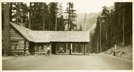
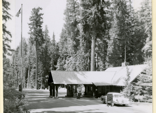
Mount Rainier National Park Archives Photo of the White River Ranger Station, circa 1931, with the porte-cochère extending out over the road.
White River Entrance is in the northeast corner of Mount Rainier National Park and was built between 1929-1931 in anticipation of the opening of Sunrise Road in 1931. It replaced an earlier entrance station that had been built in 1915. The new White River Entrance was modeled after the Nisqually Entrance, the first entrance in the park located in the southwest corner. The White River Ranger Station, which served as a combined office and checking station, was constructed of whole logs with a cedar shingle roof in the NPS Rustic style of architecture. A large porte-cochère, a roof extending out over the roadway, was added to the design to help serve visitors during poor weather. A few years later, a very similar porte-cochère was added to the Nisqually Entrance checking station.
Mount Rainier National Park Archives Photos: a ranger handing out the first visitor permit, 7/15/1931, (left), and the ranger station in 1960 with the center kiosk (right).
The White River porte-cochère was altered three times over the years, at one point extending over two lanes with a fee kiosk in the middle, before ultimately being downsized to its current smaller configuration that no longer allows vehicles. The current entrance kiosks were built in 2001 and the historic ranger station now serves as the White River Wilderness Information Center. White River Ranger Station is a contributing building to the Mount Rainier National Historic Landmark District.

NPS/E. Brouwer Photo of the White River Ranger Station in 2014.
Did you visit White River Ranger Station when it was still the checking station or have you stopped to get wilderness information there during the summer?
~kl
#Historic Mount Rainier#mount rainier national park#White River#White River Entrance#White River Ranger Station#history#historic structure#NPS Rustic#rustic architecture
89 notes
·
View notes
Text

NPS Photo of Stevens Canyon Road viewed from Faraway Rock above Reflection Lakes.
When the National Park Service was created in 1916, the enabling legislation that created the park “for the benefit and enjoyment of the people” also mandated that the land be retained in its natural condition, protected from “injury and spoliation.” So, as Mount Rainier National Park was being developed, park officials had to provide access without marring the spectacular scenery. To solve this problem, park architects and engineers innovated a new design aesthetic that blended roads and structures with the natural landscape.
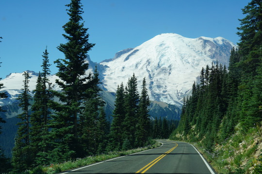
NPS Photos of Paradise Road (left) and Sunrise Road (right).
The parkwide road and bridge system built between 1920 and 1957 featured natural materials such as local stone and wood. Roads curved with the landscape to reveal views and bridges framed waterfalls. This “NPS Rustic” style of architecture became the design standard for the National Park Service. Today, Mount Rainier’s innovative roads and bridges are still preserved as part of the park’s National Historic Landmark District.
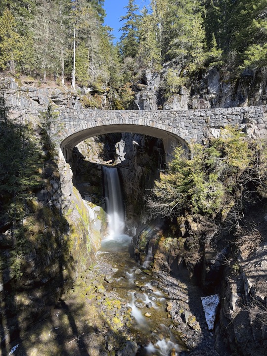
NPS Photo of Christine Falls Bridge.
#National Park Week#mount rainier national park#NPS Rustic#rustic architecture#National Historic Landmark District#historic roads#Christine Falls#Christine Falls bridge#historic bridge#Sunrise Road#Paradise Road
28 notes
·
View notes
Text
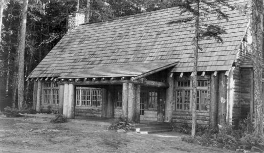
Mount Rainier National Park Archives Photo of the Longmire Community Building, circa 1927.
The Longmire Community Building was built in 1927 and is located on the east bank of the Nisqually River, on the opposite side of the river from the main Longmire area. Built in the NPS Rustic style of architecture, it is a timber-frame, two-story building with whole-log posts, beams, and rafters, a stone masonry chimney, and a large, roofed porch. As an excellent example of NPS Rustic design, the Longmire Community Building is individually designated a National Historic Landmark, in addition to being a contributing building in the Mount Rainier National Park Historic Landmark District. Closed to the public, the building serves as a gathering and training place for park employees and volunteers.

NPS Photo of Longmire Community Building in winter, 12/6/16.
The Community Building is one of the stops along the Longmire Historic District Walking Tour (also available in the NPS App). Have you used that tour to explore Longmire?
~kl
#Historic Mount Rainier#mount rainier national park#Longmire#Longmire Community Building#NPS Rustic#rustic architecture#architecture#national historic landmark
42 notes
·
View notes
Text
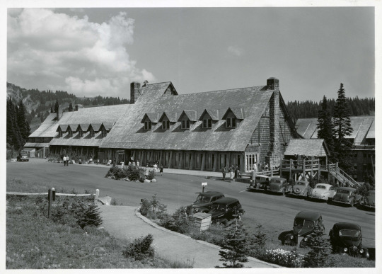

Mount Rainier National Park Archives Photos of the Paradise Inn exterior in 1940-41 (top) and NPS Photo of the Paradise Inn in 2018.
The Paradise Inn was built in 1917 by the Rainier National Park Company concessionaire. While built of wood and stone similar to other NPS rustic-style buildings found in the park, the Paradise Inn is more “whimsical” in design and meant to be reminiscent of European alpine resort architecture. The Paradise Inn is part of the Mount Rainier National Historic Landmark District but is also independently designated a National Historic Landmark for its architectural style.
One of the popular features of the Paradise Inn are the lanterns in the lobby painted with wildflowers. When the inn first opened, it had Japanese lanterns in the lobby, as seen in this 1919 photo of the interior:

Mount Rainier National Park Archives Photos of the Paradise Inn interior in 1919 with Japanese lanterns.
The first lampshades featuring wildflowers were added in the 1930s, mostly painted by the wives of rangers at the time, and the current lampshades were painted by retired Chief Naturalist Dale Thompson in 1989.

NPS Photo of wildflower lanterns inside the Paradise Inn, 2018.
Have you visited the Paradise Inn during the summer and viewed the wildflower lanterns in the lobby?
#Mount Rainier History#mount rainier national park#Paradise Inn#Paradise#history#architecture#national historic landmark#national historic landmark district
54 notes
·
View notes
Text

Mount Rainier National Park Archives Photo of the South Blockhouse in 1930.
#HistoricMountRainier The design of the Sunrise area departs from the “NPS Rustic” style set by the Longmire Area, and is instead inspired by early territorial outposts of the Pacific Northwest. Two “blockhouses”, a visitor center, and a stockade fence that hides the area’s utility yard are collectively known as the Yakima Park Stockade Group. The Stockade Group is separately designated as a National Historic Landmark for its architectural significance in addition to being part of the Mount Rainier National Historic Landmark District.

Mount Rainier National Park Archives Photo of the Sunrise Visitor Center under construction circa 1943.
The Stockade Group was not built simultaneously. The South Blockhouse was one of the first buildings to be built in the area in 1930. It served as an interpretive center and ranger station until the visitor center was built in 1943. The North Blockhouse was completed in 1944. Both blockhouses currently serve as employee housing.

NPS Photo of the Yakima Park Stockade Group in 2015.
Have you visited Sunrise during the summer and stopped in the historic visitor center?
#mount rainier national park#mount rainier#Sunrise#Sunrise Visitor Center#Yakima Park Stockade Group#national historic landmark district#national historic landmark#history#architecture#PNW History
34 notes
·
View notes
Text
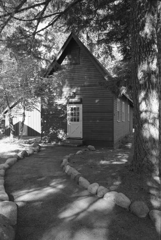
Mount Rainier National Park Archives Photo courtesy Val Lou of the Longmire Library in 1990s.
Most of the buildings in Longmire are excellent examples of the “National Park Service Rustic” style of architecture, which utilizes local materials like wood and stone to match the buildings to their environment. However, the Longmire Library predates the NPS Rustic style and serves as an example of an early, pre-NPS government building. The Longmire Library, completed in 1910, is the oldest government-built structure in Longmire. It features a steeply-pitched cedar shingle roof to shed snow and rough lapped Douglas-fir siding.
It first served as a community kitchen before becoming a library in the 1920s. From the 1950s to the 1970s, it was a branch of the Pierce County library system. Afterwards, the building served other purposes, such as a clubhouse for the Youth Conservation Corps. After its renovation in 1981, the building resumed its role as the park library where staff research the park's history and resources.
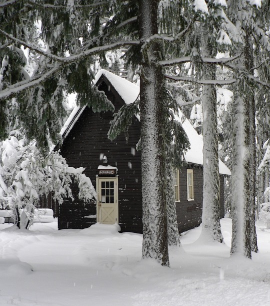
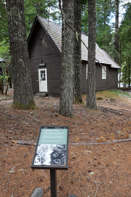
NPS Photos of the Longmire Library in winter in 2012 (left) and in summer in 2022 (right).
The Longmire Library is a contributing structure in the Mount Rainier Historic Landmark District and one of the stops along the Historic Longmire Walking Tour. Stop in the Longmire Museum for a map of the walking tour or use the NPS App to follow the self-guided tour the next time you are in Longmire.
#mount rainier national park#Historic Mount Rainier#Longmire#Longmire Library#National Historic Landmark District
19 notes
·
View notes