#University Jackson School of Geosciences
Text
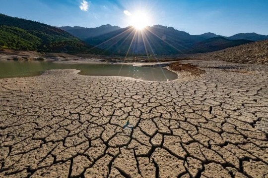
A file photo shows ground parched by drought. The climate is changing in the U.S. Huseyin Bostanci/Getty Images
Sudden Shifts From Drought to Floods Are Getting More Common in the U.S.
— By Robyn White | August 31, 2023
Sudden shifts from drought conditions to heavy floods are becoming more common in the U.S. as the climate changes, a study has found.
The findings were presented in a study published in Communications Earth & Environment. Researchers from the University of Texas, the Hong Kong Polytechnic University Research Institute for Land and Space, and Columbia University's Department of Earth and Environmental Engineering, also found that so-called feedback loops—a process that can either increase or decrease the effects of greenhouse gases—are likely contributing.
"We are especially concerned with the sudden shift from drought to flood," co-author Zong-Liang Yang, a professor at The University of Texas at Austin Jackson School of Geosciences, said in a statement on the findings. "Society usually has difficulty responding to one kind of natural disaster like drought, but now you suddenly have floods too. And this has been happening in many places."
The findings were reached based on four decades of meteorological and hydrological data from hotspots around the world, including eastern North America, Europe, East Asia, Southeast Asia, southern Australia, southern Africa and southern South America, according to the statement.
Over time, from 1980 to 2020, researchers found that such whiplash trends in the weather increased approximately a quarter of a percent to 1% per year. These extreme shifts in weather patterns have manifested in parts of the U.S. recently, and in California in particular.
The state, which has been suffering from extreme drought conditions in recent years, was battered with record amounts of rainfall from December 2022 until early spring this year. The storms were so severe that catastrophic flooding was seen in many places.
While many thought that the increase in wet weather may help ease the drought, experts have warned that it will only be a short-term solution. As the drought in the western U.S. has stretched on for so long, it will still take years of above average rainfall for the region to fully recover.
Other factors as well as climate change may be contributing to these sudden weather changes, including the El Niño and La Niña climate patterns.
Feedback loops can also be to blame. Researchers found that during periods of heavy drought in humid areas, precipitation is pushed into the air, providing an additional moisture source, the study reported. This can then cause heavy rainfall.
Periods of drought in arid regions, can also see hot weather and low pressure colliding together, drawing moisture from other sources, such as the ocean.
"Climate change is fueling back-to-back droughts and floods which have caused widespread devastation, resulting in loss of life and damage to property, infrastructure, and the environment," said co-author Shuo Wang, an associate professor at The Hong Kong Polytechnic University. "Our findings provide insights into the development of early warning systems for mitigating the impacts of rapid dry-wet transitions."
#Tech & Science#Drought#Sudden Shift#Floods#Robyn White#Climate Changes#Communications Earth & Environment#University of Texas | Hong Kong Polytechnic University | Columbia University#Zong-Liang Yang | Professor | The University of Texas at Austin | Jackson School of Geosciences#Eastern North America | Southern South America#Europe | East Asia | Southeast Asia | Southern Australia | Southern Africa#California#Storms ☔️ | Catastrophic Flooding#El Niño | La Niña#Shuo Wang | Associate Professor | The Hong Kong Polytechnic University#Early Warning Systems#Dry-Wet Transitions
0 notes
Text

New models show little groundwater recharge in ancient Mars aquifer
Mars was once a wet world. The geological record of the Red Planet shows evidence for water flowing on the surface – from river deltas to valleys carved by massive flash floods.
But a new study shows that no matter how much rainfall fell on the surface of ancient Mars, very little of it seeped into an aquifer in the planet’s southern highlands.
A graduate student at The University of Texas at Austin made the discovery by modeling groundwater recharge dynamics for the aquifer using a range of methods – from computer models to simple back-of-the-envelope calculations.
No matter the degree of complexity, the results converged on the same answer – a miniscule .03 millimeters of groundwater recharge per year on average. That means that wherever rain fell in the model, only an average of .03 millimeters per year could have entered the aquifer and still produced the landforms remaining on the planet today.
For comparison, the annual rate of groundwater recharge for the Trinity and Edwards-Trinity Plateau aquifers that provide water to San Antonio generally ranges from 2.5 to 50 millimeters per year, or about 80 to 1,600 times the Martian aquifer recharge rate calculated by the researchers.
There are a variety of potential reasons for such low groundwater flow rates, said lead author Eric Hiatt, a doctoral student at the Jackson School of Geosciences. When it rained, the water may have mostly washed across the Martian landscape as runoff. Or it may have just not rained very much at all.
These findings can help scientists constrain the climatic conditions capable of producing rainfall on early Mars. They also suggest a very different water regime on the Red Planet than what exists on Earth today.
“The fact that the groundwater isn’t as big of a process could mean that other things are,” Hiatt said. “It might magnify the importance of runoff, or it could mean that it just didn’t rain as much on Mars. But it’s just fundamentally different from how we think about [water] on Earth.”
The results were published in the journal Icarus. The paper’s co-authors are Mohammad Afzal Shadab, a doctoral student at the Jackson School and faculty members Sean Gulick, Timothy Goudge and Marc Hesse.
The models used in the study work by simulating groundwater flow in a “steady state” environment where inflow and outflow of water into the aquifer is balanced. Scientists then changed the parameters affecting the flow – for example, where rain falls or the average porosity of the rock – and observed what other variables would have to change to maintain the steady state and how plausible those charges are.
While other researchers have simulated groundwater flow on Mars using similar techniques, this model is the first to incorporate the influence of the oceans that existed on the surface of Mars more than three billion years ago in the Hellas, Argyre, and Borealis basins.
The study also incorporates modern topographical data collected by satellites. The modern landscape, Hiatt said, still preserves one of the planet’s oldest and most influential topographical features – an extreme difference in elevation between the northern hemisphere – the lowlands – and the southern hemisphere – the highlands – known as the “great dichotomy.” The dichotomy preserves signs of past groundwater upwelling in which groundwater rose up from the aquifer to the surface. The researchers used geological markers of these past upwelling events to evaluate different model outputs.
Across different models, the researchers found the mean groundwater recharge rate of .03 millimeters per year to match most closely with what’s known about the geologic record.
The research isn’t just about understanding the Red Planet’s past. It has implications for future Mars exploration too. Understanding groundwater flow can help inform where to find water today, Hiatt said. Whether you’re looking for signs of ancient life, trying to sustain human explorers, or making rocket fuel to get back home to Earth, it’s essential to know where the water would most likely be.
The research was funded by NASA, the University of Texas Institute for Geophysics, and the UT Center for Planetary Habitability.
2 notes
·
View notes
Text
Fossil places extinct saber-toothed cat on Texas coast
New Post has been published on https://petn.ws/bO1Fb
Fossil places extinct saber-toothed cat on Texas coast
This article has been reviewed according to Science X’s editorial process and policies. Editors have highlighted the following attributes while ensuring the content’s credibility: fact-checked trusted source proofread Ok! A skull from the saber-toothed cat Homotherium that is part of the Jackson School of Geosciences’ Vertebrate Paleontology Collections. Credit: University of Texas at Austin × close […]
See full article at https://petn.ws/bO1Fb
#CatsNews
0 notes
Text
24-02 honest about climate and energy
Teddynews 2024-02: Scott Tinker:
Ehrliche Worte zum Thema Klima und Energie
Scott Tinker brings industry, government, academia, and nongovernmental organizations together to address major societal challenges in energy, the environment, and the economy. Dr. Tinker is Director of the Bureau of Economic Geology, the State Geologist of Texas, and a professor holding the Allday Endowed Chair in the Jackson School of Geosciences at The University of Texas at Austin. With Director Harry Lynch, Tinker co-produced the award-winning documentary films Switchand Switch On, which have been screened in over 50 countries. Dr. Tinker founded the nonprofit Switch Energy Alliance, whose educational materials appear from schools to board rooms globally. Tinker is the host of PBS Energy Switch, an energy and climate talk show appearing on over 200 PBS stations nationwide, and Earth Date, featured weekly on over 450 public radio stations in all 50 United States. In his visits to some 60 countries, Scott has given over 1000 keynote and invited lectures. Dr. Tinker presented a TEDx talk on The Dual Challenge: Energy and Environment. Scott serves on public company boards and science councils, Trinity University’s Board of Trustees, and is an angel investor who has helped bring companies from startup to acquisition. His writing has appeared from Forbes to Fortune to Scientific American. Dr. Tinker has served as president of several international professional associations and is an AGI Campbell Medalist, AAPG Halbouty Medalist, GCAGS Boyd Medalist, AIPG Parker Medalist, and a Geological Society of America Fellow.
0 notes
Link
[ad_1] Newswise — A new study published in IOP Publishing’s journal Environmental Research Letters examines the links between drinking water quality violations and social vulnerability in the United States, revealing that these violations disproportionately affect the most vulnerable communities. Approximately 70% of the population affected ranked in the highest social vulnerability category, with many different social parameters, beyond income, linked to different drinking water quality violations. The study, led by researchers from the Jackson School of Geosciences, University of Texas in Austin, used new water quality data that reflect actual water distribution, not administrative boundaries, along with improved definitions of disadvantaged communities and social vulnerability. The improved model identifies more than three times the number of affected people than predicted by current federal environmental justice assessment tools. While most Americans have access to safe drinking water, around one in ten people were exposed to a health-based water quality violation between 2018 and 2020. In the United States, supplying high quality water is increasingly challenging, due to an aging and underfunded drinking water infrastructure. The largest causes of health-based violations in community water systems are disinfectants and byproducts related to water treatment, followed by naturally occurring contaminants (such as arsenic and radionuclides) and human-caused contaminants such as nitrates. In assessing which communities and groups are most affected by water violations, previous research has been limited by data sets that are based on state and administrative boundaries that hide the cross border nature of water distribution, and by federal environmental justice assessment tools that have focused primarily on household income as an indicator of social vulnerability, potentially neglecting key, data-available aspects of vulnerability. This study instead looked at data based on community water systems across the whole country in relation to an improved measure of social vulnerability, the mSVI, developed from a tool from the Center for Disease Control, and informed by more recent literature and data analytics. Proposed federal drinking water infrastructure funding requires individual states to allocate over 49% of the funding to disadvantaged communities (DACs). However, states have substantial discretion in defining DACs, resulting in large variations in definitions across the US. This study suggests that a broader definition of DACs, beyond household income, should be considered, as mSVI captures three times more of the affected population than household income alone. Bridget Scanlon, Senior Research Scientist for The Bureau of Economic Geology at The University of Texas, says: "Our detailed analysis of the linkages of drinking water quality violations to social vulnerability can help inform guidance for effectively distributing infrastructure funding and designing interventions to ensure more equitable drinking water quality nationally.” Dr Scanlon published her research through a transformative agreement between IOP Publishing and The University of Texas System. This agreement enables corresponding authors at the university to publish their work in more than 70 IOP journals at no cost to them. Articles published under a transformative agreement are immediately available and free for everyone to read. window.fbAsyncInit = function () FB.init( appId: '890013651056181', xfbml: true, version: 'v2.2' ); ; (function (d, s, id) var js, fjs = d.getElementsByTagName(s)[0]; if (d.getElementById(id)) return; js = d.createElement(s); js.id = id; js.src = " fjs.parentNode.insertBefore(js, fjs); (document, 'script', 'facebook-jssdk')); [ad_2]
0 notes
Text
Golden fossils reveal origins of exceptional preservation
A recent study by scientists at The University of Texas at Austin and collaborators found that many of the fossils from Germany’s Posidonia shale do not get their gleam from pyrite, commonly known as fool’s gold, which was long thought to be the source of the shine. Instead, the golden hue is from a mix of minerals that hints at the conditions in which the fossils formed.
The discovery is important for understanding how the fossils — which are among the world’s best-preserved specimens of sea life from the Early Jurassic — came to form in the first place, and the role that oxygen in the environment had in their formation.
“When you go to the quarries, golden ammonites peek out from black shale slabs,” said study co-author Rowan Martindale, an associate professor at the UT Jackson School of Geosciences. “But surprisingly, we struggled to find pyrite in the fossils. Even the fossils that looked golden, are preserved as phosphate minerals with yellow calcite. This dramatically changes our view of this famous fossil deposit.”
The research was published in Earth Science Reviews. Drew Muscente, a former assistant professor at Cornell College and former Jackson School postdoctoral researcher, led the study.
The fossils of the Posidonia Shale date back to 183 million years ago, and include rare soft-bodied specimens such as ichthyosaur embryos, squids with ink-sacs, and lobsters. To learn more about the fossilization conditions that led to such exquisite preservation, the researchers put dozens of samples under scanning electron microscopes to study their chemical composition.
“I couldn’t wait to get them in my microscope and help tell their preservational story,” said co-author Jim Schiffbauer, an associate professor at the University of Missouri Department of Geological Sciences, who handled some of the larger samples.
The researchers found that in every instance, the fossils were primarily made up of phosphate minerals even though the surrounding black shale rock was dotted with microscopic clusters of pyrite crystals, called framboids.
“I spent days looking for the framboids on the fossil,” said co-author Sinjini Sinha, a doctoral student at the Jackson School. “For some of the specimens, I counted 800 framboids on the matrix while there was maybe three or four on the fossils.”
The fact that pyrite and phosphate are found in different places on the specimens is important because it reveals key details about the fossilization environment. Pyrite forms in anoxic (without oxygen) environments, but phosphate minerals need oxygen. The research suggests that although an anoxic seafloor sets the stage for fossilization — keeping decay and predators at bay — it took a pulse of oxygen to drive the chemical reactions needed for fossilization.
These findings complement earlier research carried out by the team on the geochemical conditions of sites known for their caches of exceptionally preserved fossils, called konservat-lagerstätten. However, the results of these studies contradict long-standing theories about the conditions needed for exceptional fossil preservation in the Posidonia.
“It’s been thought for a long time that the anoxia causes the exceptional preservation, but it doesn’t directly help,” said Sinha. “It helps with making the environment conducive to faster fossilization, which leads to the preservation, but it’s oxygenation that’s enhancing preservation.”
It turns out, the oxygenation — and the phosphate and accompanying minerals — also enhanced the fossil’s shine.
The research was funded by Cornell College and the National Science Foundation. The Posidonia fossil specimens used in this study are now part of the collections at the Jackson School’s Non-Vertebrate Paleontology Laboratory.
0 notes
Video
youtube
UMA MISTERIOSA CAMADA DE ROCHA DERRETIDA É DESCOBERTA ABAIXO DAS PLACAS ...
ASSINE JÁ O SPACE TODAY PLUS E TENHA ACESSO A CENTENAS DE CONTEÚDOS INÉDITOS E EM PORTUGUÊS SOBRE ASTRONOMIA E ASTRONÁUTICA POR APENAS R$29,90 POR MÊS!!! https://quero.plus OUÇA O PODCAST HORIZONTE DE EVENTOS: https://www.spreaker.com/episode/52441779 Cientistas descobriram uma nova camada de rocha parcialmente derretida sob a crosta terrestre que pode ajudar a resolver um debate de longa data sobre como as placas tectônicas se movem. Os pesquisadores já haviam identificado manchas de derretimento em uma profundidade semelhante. Mas um novo estudo conduzido pela Universidade do Texas em Austin revelou pela primeira vez a extensão global da camada e sua participação nas placas tectônicas. A pesquisa foi publicada hoje (6 de fevereiro de 2023) na revista Nature Geoscience . A camada fundida está localizada a cerca de 160 quilômetros da superfície e faz parte da astenosfera, que fica sob as placas tectônicas da Terra no manto superior. A astenosfera é importante para as placas tectônicas porque forma um limite relativamente suave que permite que as placas tectônicas se movam através do manto. As razões pelas quais é macio, no entanto, não são bem compreendidas. Os cientistas pensavam anteriormente que as rochas derretidas poderiam ser um fator. Mas este estudo mostra que o derretimento, de fato, não parece influenciar notavelmente o fluxo das rochas do manto. “Quando pensamos em algo derretendo, pensamos intuitivamente que o derretimento deve desempenhar um grande papel na viscosidade do material”, disse Junlin Hua, um pós-doutorando da Jackson School of Geosciences da UT, que liderou a pesquisa. “Mas o que descobrimos é que, mesmo onde a fração derretida é bastante alta, seu efeito no fluxo do manto é muito menor”. De acordo com a pesquisa, que Hua iniciou como estudante de pós-graduação na Brown University, a convecção de calor e rocha no manto é a influência predominante no movimento das placas. Embora o interior da Terra seja em grande parte sólido, durante longos períodos de tempo, as rochas podem se deslocar e fluir como mel. Mostrar que a camada de fusão não tem influência nas placas tectônicas significa uma variável menos complicada para modelos de computador da Terra, disse o coautor Thorsten Becker, professor da Jackson School. “Não podemos descartar que o derretimento local não importa”, disse Becker, que projeta modelos geodinâmicos da Terra no Instituto de Geofísica da Jackson School da Universidade do Texas. “Mas acho que isso nos leva a ver essas observações de derretimento como um marcador do que está acontecendo na Terra, e não necessariamente uma contribuição ativa para qualquer coisa.” A ideia de procurar uma nova camada no interior da Terra surgiu quando Hua estudava imagens sísmicas do manto sob a Turquia durante sua pesquisa de doutorado. Intrigado com sinais de rocha parcialmente derretida sob a crosta, Hua compilou imagens semelhantes de outras estações sísmicas até obter um mapa global da astenosfera. O que ele e outros consideraram uma anomalia era de fato comum em todo o mundo, aparecendo em leituras sísmicas onde quer que a astenosfera fosse mais quente. A próxima surpresa veio quando ele comparou seu mapa de derretimento com medições sísmicas de movimento tectônico e não encontrou nenhuma correlação, apesar da camada derretida abranger quase metade da Terra. FONTE: https://scitechdaily.com/groundbreaking-discovery-of-hidden-molten-rock-layer-under-earths-tectonic-plates/ https://www.nature.com/articles/s41561-022-01116-9 #EARTH #EARTHQUAKE #LIFE
0 notes
Text
Air pollution can amplify negative effects of climate change, new study finds
https://sciencespies.com/environment/air-pollution-can-amplify-negative-effects-of-climate-change-new-study-finds/
Air pollution can amplify negative effects of climate change, new study finds
The impacts of air pollution on human health, economies, and agriculture differ drastically depending on where on the planet the pollutants are emitted, according to a new study that could potentially incentivize certain countries to cut climate-changing emissions.
Led by The University of Texas at Austin and the University of California San Diego, the study, which was published Sept. 23 in Science Advances, is the first to simulate how aerosol pollution affects both climate and air quality for locations around the globe.
Aerosols are tiny solid particles and liquid droplets that contribute to smog and are emitted from industrial factories, power plants and vehicle tailpipes. They impact human health, agricultural and economic productivity in unique global patterns when compared with carbon dioxide (CO2) emissions, which are the focus of efforts to mitigate climate change.
Although CO2 and aerosols are often emitted at the same time during the combustion of fuel, the two substances behave differently in Earth’s atmosphere, said co-lead author Geeta Persad, an assistant professor at the UT Austin Jackson School of Geosciences.
“Carbon dioxide has the same impact on climate no matter who emits it,” said Persad. “But for these aerosol pollutants, they tend to stay concentrated near where they’re emitted, so the effect that they have on the climate system is very patchy and very dependent on where they’re coming from.”
The researchers found that, depending on where they are emitted, aerosols can worsen the social costs of carbon — an estimate of the economic costs greenhouse gasses have on society — by as much as 66%. The scientists looked at eight key regions: Brazil, China, East Africa, Western Europe, India, Indonesia, United States and South Africa.
advertisement
“This research highlights how the harmful effects of our emissions are generally underestimated,” said Jennifer Burney, co-lead author and the Marshall Saunders Chancellor’s Endowed Chair in Global Climate Policy and Research at the UC San Diego School of Global Policy and Strategy. “CO2 is making the planet warmer, but it also gets emitted with a bunch of other compounds that impact people and plants directly and cause climate changes in their own right.”
The work, which was supported by the National Science Foundation, represents a collaboration between Persad and Burney, who are physical scientists, and a group of economists and public health experts. Co-authors include Marshall Burke, Eran Bendavid, and Sam Heft-Neal at Stanford University and Jonathan Proctor at Harvard University.
Aerosols can directly affect human health and the climate independently of CO2. They are associated with negative health impacts when inhaled, and can affect the climate by influencing temperature, precipitation patterns and how much sunlight reaches the Earth’s surface.
To study aerosols’ influence in comparison to CO2, the team created a set of climate simulations using the Community Earth System Model version 1 developed by the National Center for Atmospheric Research. They ran simulations in which each of the eight regions produced identical aerosol emissions and mapped how temperature, precipitation, and surface air quality were affected across the globe. Then they connected this data with known relationships between climate and air quality and infant mortality, crop productivity, and gross domestic product across the eight regions. In a final step, they compared the total societal costs of these aerosol-driven impacts against the societal costs of co-emitted CO2 in each of the eight regions, and produced global maps of the combined effects of aerosols and CO2. The researchers said the study is a big step forward from previous work, which either only estimated the air quality impacts of aerosols or didn’t consider their diverse global climate effects.
The outcome paints a varied and complicated picture. Emissions from some regions produce climate and air quality effects that range from two to more than 10 times as strong as others and social costs that sometimes affect neighboring regions more than the region that produced the aerosol emissions. For example, in Europe local emissions result in four times as many infant deaths outside Europe as within.
advertisement
But the researchers note that aerosol emissions are always bad for both the emitter and the planet overall.
“While we might think about aerosols, which cool the climate, as having the silver lining of counteracting CO2-driven warming, when we look at all these effects in combination, we find that no region experiences overall local benefits or generates overall global benefits by emitting aerosols,” said Persad.
Researchers also said the findings create potentially new motivations for countries to cut emissions — and to care about other countries cutting emissions. For example, the study found that adding aerosol costs to CO2 costs could double China’s incentive to mitigate emissions. And it switches the impact of local emissions in Europe from a net local benefit to a net cost. The study also shows that some emerging economies, like East African nations and India, might be motivated to collaborate on emission cuts since they are strongly impacted by each other’s emissions.
The framework developed in this study can also be applied to maximize societal benefits from current mitigation strategies being considered by policy makers. For example, the researchers applied it to the “fair-share” approach laid out in the Paris Climate Agreement in which all countries target the same per-capita CO2 emissions. They found the approach, while beneficial for climate stability, does not improve the mortality and crop impacts from combined aerosol and CO2 emissions because it focuses mitigation in regions that already have fairly low aerosol impacts, like the U.S. and Europe.
“By expanding societal cost calculations to include the geographically-resolved societal impacts of co-emitted aerosols, we’re showing that the incentive for individual countries to mitigate and collaborate on mitigation is much higher than if we only think about greenhouse gases,” Burney said.
#Environment
#2022 Science News#9-2022 Science News#acts of science#Earth Environment#earth science#Environment and Nature#everyday items#Nature Science#New#News Science Spies#Our Nature#planetary science#production line#sci_evergreen1#Science#Science Channel#science documentary#Science News#Science Spies#Science Spies News#September 2022 Science News#Space Physics & Nature#Space Science#Environment
0 notes
Text
Scoperti "super coralli" che prosperano in livelli elevatissimi di CO2
Scoperti "super coralli" che prosperano in livelli elevatissimi di CO2 - Nel 2019, un professore di idrologia (un esame che feci anche io presso l’Università di Ferrara) presso l’Università del Texas ad Austin ha avviato un progetto di ricerca per vedere se poteva identificare i nutrienti dannosi che fluiscono attraverso le acque sotterranee in un delicato santuario della barriera corallina nelle Filippine.
Un nuovo articolo su http://www.danireef.com/2021/10/07/scoperti-super-coralli-che-prosperano-in-livelli-elevatissimi-di-co2/
Scoperti "super coralli" che prosperano in livelli elevatissimi di CO2
#Acidificazione, #AcidificazioneDegliOceani, #ACSESTWater, #AnidrideCarbonica, #BayaniCardenas, #Co2, #Filippine, #Ricerca, #SouthernCrossUniversity, #UniversitàDelTexasAdAustin, #UniversityJacksonSchoolOfGeosciences
- by Danilo Ronchi
#acidificazione#Acidificazione degli Oceani#ACS ES&T Water#anidride carbonica#Bayani Cardenas#co2#filippine#ricerca#Southern Cross University#Università del Texas ad Austin#University Jackson School of Geosciences#NEWS
0 notes
Link
It’s older than any known fossil of an insect, arachnid, or other related creepy-crawly, according to new research.
The findings offer new evidence about the origin and evolution of bugs and plants, suggesting that they evolved much more rapidly than some scientists believe, going from lake-hugging communities to complex forest ecosystems in just 40 million years.
“It’s a big jump from these tiny guys to very complex forest communities, and in the scheme of things, it didn’t take that long,” says Michael Brookfield, a research associate at the University of Texas at Austin’s Jackson School of Geosciences and adjunct professor at the University of Massachusetts Boston.
“It seems to be a rapid radiation of evolution from these mountain valleys, down to the lowlands, and then worldwide after that.”
Continue Reading.
576 notes
·
View notes
Photo


Underwater snow gives clues about Europa's icy shell Below Europa's thick icy crust is a massive, global ocean where the snow floats upwards onto inverted ice peaks and submerged ravines. The bizarre underwater snow is known to occur below ice shelves on Earth, but a new study shows that the same is likely true for Jupiter's moon, where it may play a role in building its ice shell. The underwater snow is much purer than other kinds of ice, which means Europa's ice shell could be much less salty than previously thought. That's important for mission scientists preparing NASA's Europa Clipper spacecraft, which will use radar to peek beneath the ice shell to see if Europa's ocean could be hospitable to life. The new information will be critical because salt trapped in the ice can affect what and how deep the radar will see into the ice shell, so being able to predict what the ice is made of will help scientists make sense of the data. The study, published in the August edition of the journal Astrobiology, was led by The University of Texas at Austin, which is also leading the development of Europa Clipper's ice penetrating radar instrument. Knowing what kind of ice Europa's shell is made of will also help decipher the salinity and habitability of its ocean. "When we're exploring Europa, we're interested in the salinity and composition of the ocean, because that's one of the things that will govern its potential habitability or even the type of life that might live there," said the study's lead author Natalie Wolfenbarger, a graduate student researcher at the University of Texas Institute for Geophysics (UTIG) in the UT Jackson School of Geosciences. Europa is a rocky world about the size of the Earth's moon that is surrounded by a global ocean and a miles-thick ice shell. Previous studies suggest the temperature, pressure and salinity of Europa's ocean nearest to the ice is similar to what you would find beneath an ice shelf in Antarctica. Armed with that knowledge, the new study examined the two different ways that water freezes under ice shelves, congelation ice and frazil ice. Congelation ice grows directly from under the ice shelf. Frazil ice forms as ice flakes in supercooled seawater which float upwards through the water, settling on the bottom of the ice shelf. Both ways make ice that's less salty than seawater, which Wolfenbarger found would be even less salty when scaled up to the size and age of Europa's ice shell. What's more, according to her calculations, frazil ice—which keeps only a tiny fraction of the salt in seawater—could be very common on Europa. That means its ice shell could be orders of magnitude purer than previous estimates. This affects everything from its strength, to how heat moves through it, and forces that might drive a kind of ice tectonics. "This paper is opening up a whole new batch of possibilities for thinking about ocean worlds and how they work," said Steve Vance, a research scientist at NASA's Jet Propulsion Laboratory (JPL) who was not involved in the study. "It sets the stage for how we might prepare for Europa Clipper's analysis of the ice." According to co-author Donald Blankenship, a senior research scientist at UTIG and principal investigator for Europa Clipper's ice penetrating radar instrument, the research is validation for using the Earth as a model to understand the habitability of Europa. "We can use Earth to evaluate Europa's habitability, measure the exchange of impurities between the ice and ocean, and figure out where water is in the ice," he said. TOP IMAGE....Mounds of snow-like frazil ice under the Antarctic ice shelf. According to research from UT Austin, Europa's ice shell could be made of the same stuff. Credit: Helen Glazer 2015, from the project "Walking in Antarctica" (helenglazer.com) LOWER IMAGE....An illustration of NASA's Europa Clipper spacecraft flying by Jupiter's moon Europa. The spacecraft, which is planned to launch in 2024, will carry an ice-penetrating radar instrument developed by scientists at the University of Texas Institute for Geophysics. Credit: NASA/JPL-Caltech.
43 notes
·
View notes
Photo

welcome aboard, elise lund, student #46. we are excited to set sail with you ! has anyone told you that you look like kristine froseth? according to our records, you hail from kristiansand, norway, prefer preferred she/her, are cis female, and are here to study geosciences. we also see you received a spot on the ss university because of online lottery win — we won’t tell anyone. during your first few weeks here, other students said you were + free-spirited, + spontaneous, but also - self-indulgent. it sounds like you spend most of your time at the pool. upon checking your luggage, we noticed you packed a watch brought from home. hopefully your roommates don’t steal it!
hellooooo it’s lily again and here i am with a new muse and i’m super excited to get to play her! please hmu if you’d like to plot :D
01. stats
NAME: elise silje lund
NICKNAME: ellie, lis, elle
GENDER: cis female
PLACE OF BIRTH: kristiansand, norway
DATE OF BIRTH: february 28, 1998
AGE: twenty-three
SEXUAL ORIENTATION: bisexual
MAJOR: geosciences
02. information
i will write a proper bio at some point, just need to work on some details
elise was born in kristiansand, norway. the daughter of a young med student and a waitress. she was the result of a short lived relationship but from the first moment her father was present.
tw abandonment: she was just six months old when her mother walked away. she didn’t leave a note nor a place where to find her.
her father with the help of his parents was able to graduate med school and raise elise.
despite not having a motherly figure, elise had a pretty happy and comfortable childhood.
when she was six, her father took a fellowship in california and he and elise moved there.
life in the us was no much different but even at such a young age, elise missed her home.
the lunds moved back to norway when elise was fourteen and by that time she was sure she wanted to become a nurse and also work with children like her father did.
after high school, elise stayed in her hometown and attended university for two years. during her second year, she decided to on an exchange student program to the us.
that’s when her free spirited personality really took off. she began making roadtrips during the weekends or holidays and she discovered her passion for traveling.
once back in norway, elise told her father that she was dropping out to travel the world. her father was not happy about it but eventually realized that there wasn’t much he could do.
for the past three years elise has been traveling to different places, living in hostels, rental cars and coach surfing. she’s had different jobs to be able to pay for her trips and she even had a blog to talk about the places she’s visited.
a few months ago, she heard of seas university through a childhood friend and she decided to give it a chance. she never expected winning the online lottery.
this time, she decided to study geosciences and so far she can study and still travel which is exactly what she wanted.
03. current plots
friends with benefits with bentley james
longtime family friend of matias jackson
04. wanted plot
best friend: elise is super outgoing but she rarely makes long lasting friendships because of how often she used to move, but now on the ship she has found this person to be her platonic soulmate.
drinking buddies: she loves a good party and a drink after a rough day, so she always calls this person.
voice of reason: she is probably known to be wild and make some questionable choices, maybe your muse is that friend who tries to talk her down and give her alternatives to whatever crazy things she has in mind
study buddy: despite her reckless personality, elise is a good student and she takes her classes very seriously, so it’s not rare to see her in the library.
unrequited feelings: either elise or your muse admire the other from afar and somehow they havent mustered the courage to talk to the other.
ex: this was probably elise’s first and only relationship, she really loved this person but eventually she decided they were better off as friends
awkward date: they went on a date for whatever reason but it didn’t work out and they ended up never talking again.
wrong idea: elise dislikes this person because she thinks they’re not a great person but of course, all elise needs to do is give your muse a chance.
misunderstanding: these two didn’t have a great start. maybe elise threw coffee on them by accident, or was talking to your muse s/o and unintentionally seemed like she was trying a move and your character took it the wrong way.
3 notes
·
View notes
Photo

Large Fossil Egg from Antarctica May Belong to an Extinct Sea Lizard
In 2011, Chilean scientists discovered a mysterious fossil in Antarctica that looked like a deflated football. For nearly a decade, the specimen sat unlabeled and unstudied in the collections of Chile’s National Museum of Natural History, with scientists identifying it only by its sci-fi movie-inspired nickname – “The Thing.”
An analysis led by researchers at The University of Texas at Austin has found that the fossil is a giant, soft-shell egg from about 66 million years ago. Measuring in at more than 11 by 7 inches, the egg is the largest soft-shell egg ever discovered and the second-largest egg of any known animal.
The specimen is the first fossil egg found in Antarctica and pushes the limits of how big scientists thought soft-shell eggs could grow. Aside from its astounding size, the fossil is significant because scientists think it was laid by an extinct, giant marine reptile, such as a mosasaur — a discovery that challenges the prevailing thought that such creatures did not lay eggs.
“It is from an animal the size of a large dinosaur, but it is completely unlike a dinosaur egg,” said lead author Lucas Legendre, a postdoctoral researcher at UT Austin’s Jackson School of Geosciences. “It is most similar to the eggs of lizards and snakes, but it is from a truly giant relative of these animals.”
A study describing the fossil egg was published in Nature on June 17...
Read more: https://news.utexas.edu/2020/06/17/egg-from-antarctica-is-big-and-might-belong-to-an-extinct-sea-lizard/
34 notes
·
View notes
Text
Algorithms and hi-res survey data lead to census of desert shrub in Nevada

- By University of Texas at Austin -
The creosote is the king of the desert. This scraggly shrub dominates the landscape of the American southwest, creating mini-oases from the harsh heat for desert wildlife. In a new study, researchers at The University of Texas at Austin leveraged computer algorithms and high-resolution survey data to conduct the first-ever creosote census – counting every creosote in a 135-square-mile conservation site in Nevada’s Mojave Desert.
The final count was 23 million creosotes among a total population of 66 million plants.

Image: Creosote plants in Las Vegas Valley.A recent University of Texas at Austin study used aerial survey data and computer algorithms to conduct the first ever census of the desert plant. Credit: Michael Young.
The researchers discovered important new information about the plant species, but they also demonstrate how data techniques can improve on conventional methods for studying plant communities.
“This was first and foremost a big data project,” said James “Jake” Gearon, a graduate student at the UT Jackson School of Geosciences who led the study. “The majority of time was data cleaning, data investigation, data prep. By the time you get to analysis, you have discovered so many things along the way you have a path forward.”
The study was published in November 2020 in the journal Landscape Ecology.
The census is a milestone for plant science. Most plant population data comes from samples of fewer than 1,000 plants or aerial surveys that capture community snapshots. This research presents a way to account for each and every individual in a plant community. The scientists also discovered that certain landscape features can influence how big creosotes grow and how far apart they are spaced.
“People are amazed at the size of the dataset. But we tried to avoid being dazzled by size and focus on the interesting things the data tell us,” said coauthor Michael Young, a senior research scientist at the Bureau of Economic Geology, a research unit at the Jackson School.
The creosote research is built on repurposed data collected by Young and colleagues during a 2017 aerial survey that collected aerial photos and elevation data from the Boulder City Conservation Easement in the Mojave Desert.

Image: Creosotes (larger plants) and white bursage (smaller plants) cover the ground in Nevada’s Boulder City Conservation Easement. Credit: Young et al.
The data were originally collected to find burrows belonging to the threatened desert tortoise. But the high-resolution photos (one pixel is equivalent to six inches) combined with the elevation data that measured variations in each square meter of the easement, created a rich resource for new research.
Counting the creosotes involved applying computer algorithms that could distinguish the bushes from the surrounding landscape and other plants. In addition to carrying out the census, the algorithms also extracted information on each creosote’s location, height, and canopy area, from which canopy volume was calculated.They also extracted information on the surrounding landscape, such as relative soil age, and slope angle and direction.
When the landscape and creosote information were analyzed together, the researchers discovered some notable trends about how the landscape influenced plant growth.
They found that direction of the slope, or aspect, was the main control on creosote volume – with the plants growing on east-facing slopes being about five times bushier than plants on west-facing slopes.
“That’s five times more cover on the ground for the critters, for land use, or for understanding just how hot the ground is going to get – that has a huge impact,” Gearon said.
They also found that soil age influences creosote volume, with plants in the younger soil being about 27% larger than plants in the oldest.
The connection between soil age and plant size is well documented, but the influence of hillslope aspect on plant size came as a surprise, Gearon said. That’s because the research record more often relates plant growth to north and south slope directions – with few studies on east and west slopes.

Image: Geomorphic units in Nevada’s Boulder City Conservation Easement. The research found that younger units are associated with larger creosote plants. Credit: Gearon et al.
But this study suggests that growing on an eastward slope could be an important way for desert plants to stay hydrated, with the placement allowing the plants to soak up the sunshine during the cooler, wetter morning hours, unlike westward slopes which receive the most sunlight during the hottest parts of the day when they’re most susceptible to losing water via transpiration.
Erik Hamerlynk, a research ecologist at the U.S. Department of Agriculture, said the study is significant because of the precision of the data that comes from accounting for every individual in a population.
“This is the first time I’ve seen something that takes plot level data and really expands it to a landscape scale, to a basin scale,” Hamerlynk said. “That’s just a huge accomplishment.”
He added that techniques presented in the study could help improve range management practices by offering an in-depth and standardized view of an entire plant community before and after a particular intervention.
The Clark County Desert Conservation Program funded the research.
--
Source: University of Texas at Austin
Full study: “Geomorphic controls on shrub canopy volume and spacing of creosote bush in northern Mojave Desert, USA”, Landscape Ecology.
https://doi.org/10.1007/s10980-020-01149-8
Read Also
AI indicates there are hundreds of millions of trees in the Sahara
#desert#plants#shrub#algorithms#survey data#big data#biology#geology#soil#ecology#environment#earth science
6 notes
·
View notes
Text
Fossils reveal dinosaurs of prehistoric Patagonia
The fossils represent the first record of theropods — a dinosaur group that includes both modern birds and their closest non-avian dinosaur relatives — from the Chilean portion of Patagonia. The researchers’ finds include giant megaraptors with large sickle-like claws and birds from the group that also includes today’s modern species.
“The fauna of Patagonia leading up to the mass extinction was really diverse,” said lead author Sarah Davis, who completed this work as part of her doctoral studies with Professor Julia Clarke at the UT Jackson School of Geosciences Department of Geological Sciences. “You’ve got your large theropod carnivores and smaller carnivores as well as these bird groups coexisting alongside other reptiles and small mammals.”
The study was published in the Journal of South American Earth Sciences.
Since 2017, members of the Clarke lab, including graduate and undergraduate students, have joined scientific collaborators from Chile in Patagonia to collect fossils and build a record of ancient life from the region. Over the years, researchers have found abundant plant and animal fossils from before the asteroid strike that killed off the dinosaurs.
The study focuses specifically on theropods, with the fossils dating from 66 to 75 million years ago.
Non-avian theropod dinosaurs were mostly carnivorous, and include the top predators in the food chain. This study shows that in prehistoric Patagonia, these predators included dinosaurs from two groups — megaraptors and unenlagiines.
Reaching over 25 feet long, megaraptors were among the larger theropod dinosaurs in South America during the Late Cretaceous. The unenlagiines — a group with members that ranged from chicken-sized to over 10 feet tall — were probably covered with feathers, just like their close relative the velociraptor. The unenlagiinae fossils described in the study are the southernmost known instance of this dinosaur group.
The bird fossils were also from two groups — enantiornithines and ornithurines. Although now extinct, enantiornithines were the most diverse and abundant birds millions of years ago. These resembled sparrows — but with beaks lined with teeth. The group ornithurae includes all modern birds living today. The ones living in ancient Patagonia may have resembled a goose or duck, though the fossils are too fragmentary to tell for sure.
The researchers identified the theropods from small fossil fragments; the dinosaurs mostly from teeth and toes, the birds from small bone pieces. Davis said that the enamel glinting on the dinosaur teeth helped with spotting them among the rocky terrain.
Some researchers have suggested that the Southern Hemisphere faced less extreme or more gradual climatic changes than the Northern Hemisphere after the asteroid strike. This may have made Patagonia, and other places in the Southern Hemisphere, a refuge for birds and mammals and other life that survived the extinction. Davis said that this study can aid in investigating this theory by building up a record of ancient life before and after the extinction event.
Study co-author Marcelo Leppe, the director of the Antarctic Institute of Chile, said that these past records are key to understanding life as it exists today.
“We still need to know how life made its way in that apocalyptic scenario and gave rise to our southern environments in South America, New Zealand and Australia,” he said. “Here theropods are still present — no longer as dinosaurs as imposing as megaraptorids — but as the diverse array of birds found in the forests, swamps and marshes of Patagonia, and in Antarctica and Australia.”
The research was funded by the National Science Foundation, the National Agency for Research and Development of Chile, and the Jackson School of Geosciences.
The study’s co-authors include Clarke and researchers at the University of Chile, Major University, the University of Concepción and the Chilean National Museum of Natural History.
0 notes
Text
Scientists find iron 'snow' in Earth's core
The Earth's inner core is hot, under immense pressure and snow-capped, according to new research that could help scientists better understand forces that affect the entire planet.

The snow is made of tiny particles of iron -- much heavier than any snowflake on Earth's surface -- that fall from the molten outer core and pile on top of the inner core, creating piles up to 200 miles thick that cover the inner core.
The image may sound like an alien winter wonderland. But the scientists who led the research said it is akin to how rocks form inside volcanoes.
"The Earth's metallic core works like a magma chamber that we know better of in the crust," said Jung-Fu Lin, a professor in the Jackson School of Geosciences at The University of Texas at Austin and a co-author of the study.
The study is available online and will be published in the print edition of the journal JGR Solid Earth on December 23.
Youjun Zhang, an associate professor at Sichuan University in China, led the study. The other co-authors include Jackson School graduate student Peter Nelson; and Nick Dygert, an assistant professor at the University of Tennessee who conducted the research during a postdoctoral fellowship at the Jackson School.
The Earth's core can't be sampled, so scientists study it by recording and analyzing signals from seismic waves (a type of energy wave) as they pass through the Earth.
However, aberrations between recent seismic wave data and the values that would be expected based on the current model of the Earth's core have raised questions. The waves move more slowly than expected as they passed through the base of the outer core, and they move faster than expected when moving through the eastern hemisphere of the top inner core.
The study proposes the iron snow-capped core as an explanation for these aberrations. The scientist S.I. Braginkskii proposed in the early 1960s that a slurry layer exists between the inner and outer core, but prevailing knowledge about heat and pressure conditions in the core environment quashed that theory. However, new data from experiments on core-like materials conducted by Zhang and pulled from more recent scientific literature found that crystallization was possible and that about 15% of the lowermost outer core could be made of iron-based crystals that eventually fall down the liquid outer core and settle on top of the solid inner core.
"It's sort of a bizarre thing to think about," Dygert said. "You have crystals within the outer core snowing down onto the inner core over a distance of several hundred kilometers."
The researchers point to the accumulated snow pack as the cause of the seismic aberrations. The slurry-like composition slows the seismic waves. The variation in snow pile size -- thinner in the eastern hemisphere and thicker in the western -- explains the change in speed.
"The inner-core boundary is not a simple and smooth surface, which may affect the thermal conduction and the convections of the core," Zhang said.
The paper compares the snowing of iron particles with a process that happens inside magma chambers closer to the Earth's surface, which involves minerals crystalizing out of the melt and glomming together. In magma chambers, the compaction of the minerals creates what's known as "cumulate rock." In the Earth's core, the compaction of the iron contributes to the growth of the inner core and shrinking of the outer core.
And given the core's influence over phenomena that affects the entire planet, from generating its magnetic field to radiating the heat that drives the movement of tectonic plates, understanding more about its composition and behavior could help in understanding how these larger processes work.
Bruce Buffet, a geosciences professor at the University of California, Berkley who studies planet interiors and who was not involved in the study, said that the research confronts longstanding questions about the Earth's interior and could even help reveal more about how the Earth's core came to be.
"Relating the model predictions to the anomalous observations allows us to draw inferences about the possible compositions of the liquid core and maybe connect this information to the conditions that prevailed at the time the planet was formed," he said. "The starting condition is an important factor in Earth becoming the planet we know."
The research was funded by the National Natural Science Foundation of China, Fundamental Research Funds for the Central Universities, the Jackson School of Geosciences, the National Science Foundation and the Sloan Foundation.
11 notes
·
View notes
Last Seen Blogs

matrix2176
Belles Filles

smart-tech-llc-blog
Untitled

yourlocaltrashpandaa
Trashy

glizda
🦕

horrorlived
𝑯𝑨𝑼𝑵𝑻𝑬𝑫