#spatialanalysis
Explore tagged Tumblr posts
Text

Learn ArcGIS Pro – The Ultimate Udemy Course for GIS Enthusiasts
Master ArcGIS Pro in this step-by-step Udemy course! 🚀 Gain hands-on experience in spatial analysis, geoprocessing, and mapping.
🎯 Get Discount 48% off (Only $12.99 from $19.99) – Enroll today!
#ArcGISProCourse#GISTraining#LearnArcGISPro#GISSoftware#UdemyLearning#SpatialAnalysis#MappingTools#OpenSource#GISData#CartographicDesign
0 notes
Text

Discover how GIS Technology enhance climate research by providing accurate mapping, spatial analysis and real-time environmental monitoring.
0 notes
Text
Want to become an ArcGIS Desktop 10.8 expert? 🚀
English Video tutorial, just for $9.99 (NORMAL price $19.9) till 25/02/2025. Get it once and you will get endless access right
This complete guide takes you from beginner to pro, covering essential tools, data management, and spatial analysis techniques. Whether you're a student or a GIS professional, this tutorial will elevate your mapping skills!
✅ Learn hands-on GIS workflows ✅ Master spatial analysis & geoprocessing tools ✅ Create powerful maps & visualizations
0 notes
Text
Alteryx Data & Analytics
Alteryx Data & Analytics Platform: A Comprehensive Report
Alteryx Data & Analytics provide a comprehensive self-service analytics solution that caters to various data blending, preparation, and advanced analytics tasks. It delivers powerful features, predictive modeling, and spatial analysis capabilities. Introduction Alteryx is a powerful and versatile data analytics and automation platform designed to empower businesses to transform raw data into actionable insights. By unifying data preparation, blending, analysis, and visualization capabilities in a user-friendly interface, Alteryx democratizes analytics, enabling both technical and non-technical users to participate in the data-driven decision-making process. Key Components and Features - Alteryx Designer: The core of the platform, Designer offers a drag-and-drop workflow environment with over 300 pre-built tools for data access, preparation, blending, analysis, and output. Its intuitive interface allows users to visually design and automate data workflows without extensive coding knowledge. - Alteryx Server: This component enables the sharing and scheduling of workflows built in Designer, facilitating collaboration and broader access to analytics across the organization. It also enhances performance by leveraging server resources for complex data processing tasks. - Alteryx Analytics Cloud: This cloud-based platform provides a unified environment for data preparation, blending, and advanced analytics. It integrates Designer Cloud powered by Trifacta, offering AI-driven data preparation capabilities and enhanced collaboration features. - Alteryx Machine Learning: This cloud-native solution democratizes machine learning by providing an intuitive interface for building, training, and deploying predictive models. It automates key tasks like feature engineering and model selection, making machine learning accessible to a wider audience. Key Capabilities and Benefits - Data Preparation and Blending: Alteryx excels at simplifying the often complex and time-consuming process of data preparation. It allows users to connect to and integrate data from various sources, cleanse and transform data, and prepare it for analysis. - Advanced Analytics: The platform supports a wide range of analytical techniques, including statistical analysis, predictive modeling, spatial analysis, and text mining. This enables users to uncover deeper insights and make more informed decisions. - Automation and Scalability: Alteryx enables the automation of repetitive data tasks, freeing up analysts to focus on higher-value activities. Its server-based architecture ensures scalability to handle growing data volumes and user demands. - Improved Decision-Making: By providing self-service access to data and analytics, Alteryx empowers users across the organization to make data-driven decisions, leading to improved business outcomes. Use Cases Alteryx finds applications across various industries and departments, including: - Marketing: Customer segmentation, campaign analysis, and marketing performance optimization. - Sales: Sales forecasting, lead scoring, and territory analysis. - Operations: Supply chain optimization, fraud detection, and risk management. - Finance: Financial reporting, budgeting, and forecasting. - Human Resources: Workforce analytics, talent acquisition, and employee retention. Competitive Landscape Alteryx competes with other data analytics and business intelligence platforms, including: - Tableau: Focuses on data visualization and exploration. - Power BI: Microsoft's business intelligence tool with strong integration with other Microsoft products. - Qlik Sense: Offers associative data exploration and visualization capabilities. - Dataiku: Provides a collaborative platform for data scientists and business analysts. Strengths and Weaknesses Strengths: - User-friendly interface with drag-and-drop functionality. - Wide range of pre-built tools for data preparation and analysis. - Strong automation capabilities for repetitive tasks. - Scalable architecture to handle large data volumes. - Extensive community and support resources. Weaknesses: - Can be expensive for smaller organizations or individual users. - Some advanced features require coding knowledge. - Integration with certain data sources can be challenging. Conclusion Alteryx is a comprehensive and powerful data analytics platform that simplifies the process of turning data into actionable insights. Its user-friendly interface, extensive capabilities, and automation features make it a valuable tool for businesses of all sizes. By empowering users across the organization to participate in the data-driven decision-making process, Alteryx helps drive business growth and improve outcomes. Additional Resources: - Alteryx Website: https://www.alteryx.com/ - Alteryx Community: https://community.alteryx.com/ - Alteryx Academy: https://community.alteryx.com/t5/Alteryx-Academy/ct-p/alteryx-academy Read the full article
#Businessintelligence#Datablending#datapreparation#DataScience#ETL#machinelearning#Predictiveanalytics#self-serviceanalytics#spatialanalysis#workflowautomation
0 notes
Text
Happy New Year from Team CyberSWIFT!
As we step into another exciting year, we extend our heartfelt wishes to you and your family for a year filled with joy, success, and new opportunities. May 2025 bring you endless happiness, good health, and prosperity. Let’s continue to innovate, grow, and create incredible moments together!
#HappyNewYear#TeamCyberSWIFT#Welcome2025#NewYearWishes#2025#CyberSWIFT#GISSolutions#GeospatialTechnology#MappingTheFuture#GISInnovation#SmartMapping#SpatialAnalysis#GISForGood#GeoSolutions#GeospatialInsights
0 notes
Text
GIS Services in Canada
GIS services are crucial for RS Solar CAD Group's operations, aiding in site selection, solar panel placement, and infrastructure planning. Our offerings include spatial analysis, data visualization, and custom mapping solutions tailored to meet the unique needs of solar energy projects. With our expertise, RS Solar CAD Group can optimize their designs, minimize environmental impact, and maximize energy production efficiency.
Our Services include Solar Design Services | GIS | CAD/Drafting | BIM | Project management | Civil Engineering | MEP | Permit plan set
To know more contact us Email: [email protected]/ [email protected] or calling / Whatsapp at +919958060424
#gis#geospatial#mapping#geography#cartography#geodata#spatialanalysis#geoinformatics#geospatialintelligence#geospatialtechnology#permit#proposals#engineeringstamp#solar#solarenergy#solarpower#solarinstallation#usa#usajobs#california#washington#oregon#nevada#idaho#montana#arizona#utah#colorado#newmexico#texas
0 notes
Text
What is Raster Spatial Analysis in GIS? (Geographical Information System)
Raster spatial analysis in #GIS is the process of examining and interpreting information that is stored in a grid format, like pixels in a photograph.
Imagine a map divided into tiny squares, each representing a specific area. These squares hold data, such as temperature, elevation, or land use.
With raster spatial analysis, we can perform various tasks, like identifying patterns, calculating distances, or finding areas with specific characteristics.
For instance, we might use it to determine the slope of a hill, track changes in vegetation over time, or locate regions prone to flooding.
Get help for all types of #SpatialAnalysis homework, assignments and projects in GIS, from top professionals with assured 100% accuarate solutions.
Get in touch with us for help with any GIS application, such as #ArcGIS #QGIS #sagagis and more.
Visit our website for more information: https://www.urgenthomeworkhelp.com/GIS-raster-spatial-analysis.php
#GIShomeworkhelp #GISAssignmentHelp #mapcreation #UrgentHomeworkHelp #24HoursHomeworkHelp
0 notes
Text

Join the location-based services revolution! According to a report, the market is set to reach USD 39.2 billion by 2025, with a growth rate of 17.6% from 2020. Don't miss out on leveraging this technology for your business.
For more information,https://hirinfotech.com/digital-marketing/ or contact us at [email protected]
0 notes
Text

In today’s fast-paced business world, data-driven decisions are the key to success. MapInfo Pro, a leading GIS software, empowers businesses with advanced spatial analysis and data visualization capabilities. From market analysis and urban planning to environmental management and logistics, MapInfo Pro helps organizations turn complex datasets into actionable insights. In collaboration with Advintek Geoscience, this powerful tool transforms raw data into strategic decisions, improving efficiency, resource management, and competitive advantage.
Discover how MapInfo Pro revolutionizes location intelligence and fuels business growth in this in-depth article!
READ MORE: https://geosciences.advintek.com.sg/visualizing-success.../
#GIS#MapInfoPro#DataDrivenDecisions#LocationIntelligence#BusinessGrowth#SpatialAnalysis#DataVisualization#MarketInsights#GeospatialTechnology#AdvintekGeoScience
0 notes
Text
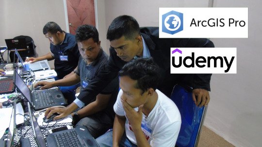
Learn ArcGIS Pro – The Ultimate Udemy Course for GIS Enthusiasts
Master ArcGIS Pro in this step-by-step Udemy course! 🚀 Gain hands-on experience in spatial analysis, geoprocessing, and mapping.
🎯 Get Discount 48% off (Only $12.99 from $19.99) – Enroll today!
#ArcGISProCourse#GISTraining#LearnArcGISPro#GISSoftware#UdemyLearning#SpatialAnalysis#MappingTools#OpenSource#GISData#CartographicDesign
0 notes
Text
"Optimizing Operations with Geospatial Solutions"
Geospatial solutions harness the power of location-based data to provide valuable insights and support informed decision-making across various industries.
https://www.globalinsightservices.com/request-sample/GIS23655@/?utm_source=SnehaPatil-Article
By integrating geographic information systems (GIS), satellite imagery, and GPS technology, these solutions enable organizations to analyze spatial patterns, optimize resource allocation, and improve operational efficiency. From urban planning and environmental management to logistics and agriculture, geospatial solutions offer versatile tools for visualizing data, predicting trends, and addressing complex challenges. With the proliferation of IoT devices and advancements in data analytics, geospatial solutions continue to evolve, empowering businesses and governments to unlock new opportunities and create sustainable, resilient communities. #Geospatial #GIS #LocationIntelligence #SpatialAnalysis #DataVisualization #SmartCities #IoT #GeospatialTechnology #DecisionMaking #UrbanPlanning #EnvironmentalManagement #Logistics #Agriculture #SustainableDevelopment #Resilience
0 notes
Text
Tải MapInfo Pro 17.0.3 Full miễn phí - Công cụ phân tích địa lý hàng đầu
MapInfo Pro 17.0.3 Full là một công cụ phân tích địa lý hàng đầu, được sử dụng rộng rãi trong các lĩnh vực như địa chính, địa kỹ thuật và quản lý địa lý. Đây là phiên bản đầy đủ, mang đến cho người dùng nhiều tính năng và chức năng hơn bản miễn phí. Để trải nghiệm toàn bộ tiềm năng của phần mềm này, bạn có thể tải xuống MapInfo Pro 17.0.3 Full.

Việc tải xuống và cài đặt mapinfo pro 17.0.3 Full rất đơn giản. Bạn chỉ cần truy cập vào trang web chính thức của MapInfo, tìm đến phiên bản 17.0.3 Full và tải xuống tệp cài đặt. Sau đó, bạn chỉ cần chạy tệp cài đặt và làm theo hướng dẫn trên màn hình.
Với MapInfo Pro 17.0.3 Full, bạn có thể thực hiện các phân tích địa lý phức tạp, tạo bản đồ chuyên nghiệp, và xem thông tin địa lý từ nhiều nguồn dữ liệu khác nhau. Phần mềm cung cấp các công cụ mạnh mẽ giúp bạn hiểu rõ hơn về môi trường xung quanh và hỗ trợ quyết định trong các dự án địa lý.
MapInfoPro17, #PhầnMềmPhânTíchĐịaLý, #DownloadMapInfoPro, #SpatialAnalysis
0 notes
Text
Mastering ArcGIS Desktop 10.8: From Zero to Zorro. English Video tutorial, just for $9.99 (NORMAL price $19.9) till 25/02/2025. Get it once and you will get endless access right.
Want to become an ArcGIS Desktop 10.8 expert? 🚀 This complete guide takes you from beginner to pro, covering essential tools, data management, and spatial analysis techniques. Whether you're a student or a GIS professional, this tutorial will elevate your mapping skills!
✅ Learn hands-on GIS workflows ✅ Master spatial analysis & geoprocessing tools ✅ Create powerful maps & visualizations
0 notes
Photo
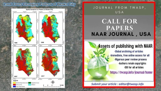
চার দশকে ঢাকা শহরের ভূমির পরিবর্তন ১৯৮৮-২০১৭ ================== Source: Bhuian, M. H. (2019), Investigation of climate scenario with their land cover condition of two major cities in Bangladesh: A spatio-temporal study, MSc. Research Project, Dept. of Geography and Environment, JnU, Dhaka, Bangladesh. =================== #ResearchProject #dhakacity #bangladesh #SpatialAnalysis #LandUse #landcovermap #naar #geoacademy #map https://www.instagram.com/p/CIUvTZ0H1N6/?igshid=1cihi4yui75t7
1 note
·
View note
Photo

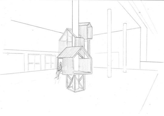
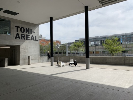


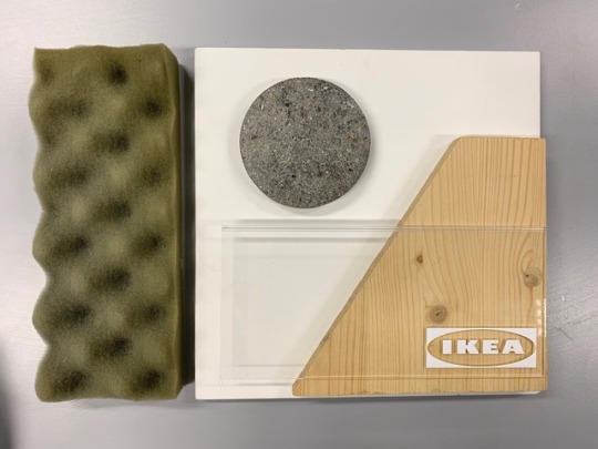
Life at school - the IKEA neighborhood at ZHdK
Small space living, togetherness, and social interaction. Our concept (Collaboration between Giada, Carina and me) incorporates topics which are highly relevant.
We felt that within the environment at Toni areal you find a lot of busy public space and a rather grey surrounding which might not be experienced as very inviting or comfortable. There is a lack of semi-public places or just a shelter where you can have a break from the noises and relax, make a phone call, take a break with only a few other people for example. The other thing is that there is not much exchange between the disciplines (design, art, dance, music, film, etc.)
That’s how we came up with the idea of the treehouses. We developed a model of around 8 square meters which could be placed on different heights, integrating the pillars which you find on different levels at ZHdK as well as the entrance shown above. On the layout, you can see how interesting it would be to figure out what fits in this limited space.
The concept is that each IDDP student would co-create a little house together with a student from the different ZHdK studying fields (dance, film, design, art, music...). This way there is social exchange during the creation process as well as in the following encounters. This neighborhood installation could be a perfect opportunity to promote IKEA, their sense for innovation and relevance amongst the creative students. To show how individual an unusual room setting could be and to promote certain products.
10 notes
·
View notes
Text
Empower Your Business with Custom Salesforce Solutions from CyberSWIFT!
Looking to streamline your operations and boost productivity? Our custom Salesforce solutions are designed to fit your business needs, helping you achieve greater efficiency and better customer engagement.
#SalesforceDevelopment#SalesforceSolutions#SalesforceConsulting#CustomSalesforce#SalesforceIntegration#SalesforceCRM#SalesforceExperts#SalesforceDeveloper#SalesforceAutomation#SalesforceCustomization#SalesforceServices#SalesforceConsultants#CRMDevelopment#CloudSolutions#SalesforcePlatform#GISSoftware#GeospatialTechnology#GISMapping#GeographicInformationSystem#LocationIntelligence#SpatialAnalysis#GISSolutions#MappingSoftware#GISDevelopment#GeospatialSolutions#GISConsulting#GISApplications#GISInnovation#GISData#GeospatialMapping
0 notes