#map of france
Text
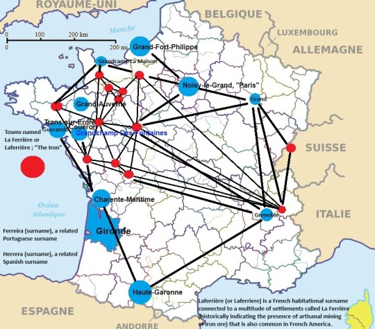
#francais#french#french diaspora#grand map#laferriere#ferriere#map of france#french map#celtic#gaul#gaulish#celt#gael#gaelic#gaulic#gaelish#maps#art#bicycle map#bicycling map#tour map#mother tongue#father tongue#english french#french english#francophile#francophone#poésie francophone#viola#europe map
0 notes
Text
2K notes
·
View notes
Text
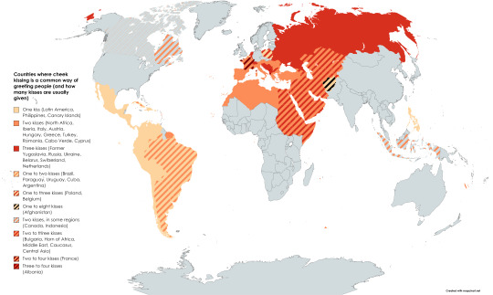
Countries where cheek kissing is a common way of greeting people
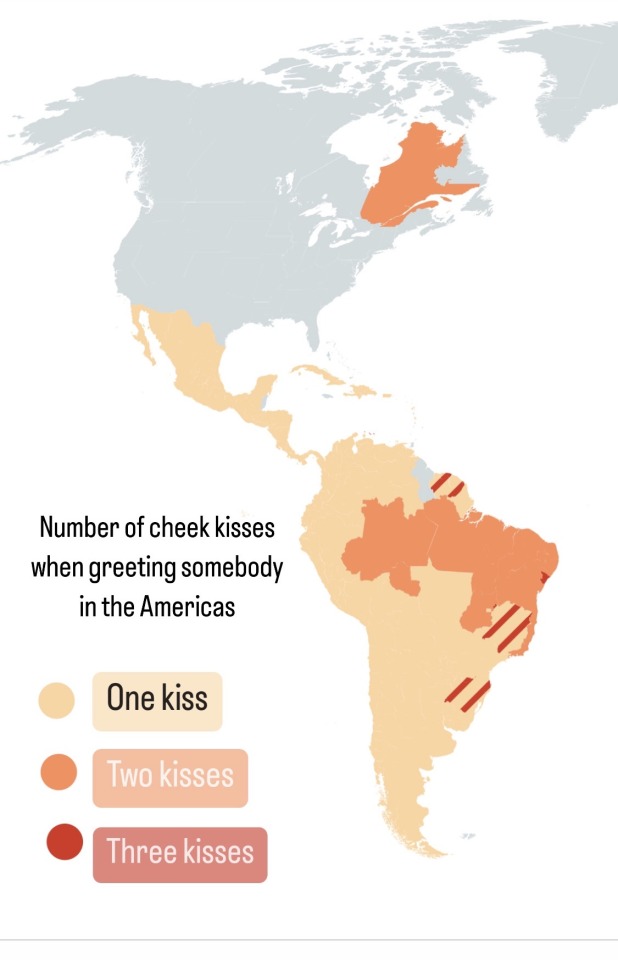
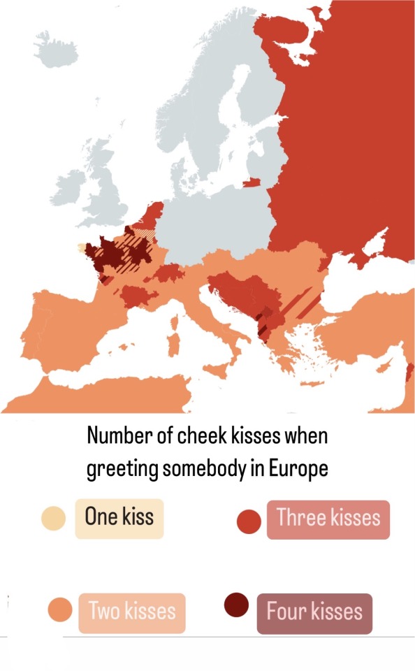
Number of cheek kisses when greeting somebody in the Americas and Europe
#map#maps#world#greeting#kiss#kisses#latin america#latina belt#data#europe#geography#americas#mexico#cartography#russia#eastern europe#slavic#slav#latin#france#french#bise#beso#spain#netherlands#north africa#mena#swana#the philippines
9K notes
·
View notes
Text
The entire west of France didn’t show up on Google Maps anymore.
555 notes
·
View notes
Photo

Regional languages in France
413 notes
·
View notes
Note
What year does synergized take place?
There is no set year, but it takes place sort of in the mid-2000s, at least technology-wise for humans. Aesthetically, it's somewhat a mix of multiple decades.
I set the technology at the mid-2000s for two main reasons. One a lot of my inspirations for this project are shows/comics from around that time, and two, the major reason I don't want to write smart phones or modern type social media. I don't find it fun to write (mostly modern social media integration), and what is considered modern changes so fast. No matter how up-to-date I try to keep it, the nature of a long-term project like this, it will fall behind anyway, so why not set it slightly in the past where I already know we're human technology is at and will go...
I kinda got a light alt-history thing going on where no real-world brands, cities, or countries are name-dropped. It feels pretty close to our world, but occasionally, a character will mention something like "at least Earth only had one world War" or how theirs a town that it and all the people living in it mysteriously all turned into solid metal like 300 years ago, also it just a tourist attraction you can just visit now or religions being different from the real-world ones, the vibes are definitely east coast America, and it is sorta set there but it is definitely not a 1 to 1 with the real world (sorta how Steven universe handled things)
#bet you weren't expecting to get a long awnser lol#im basing my Europe map off the awful Europe map in g1 with the giant france#making that one g1 animations error/horrible map canon#i dont wanna make refrances jokes or plot points based on modern things that age out of date in like two years#i like using social media from time to time but i hate writing it and anything anyone writes about it becomes out of date in like 3 years#transformers#transformers fan continuity#tfs#transformers synergize#ask answering#text post#maccadam#the alt history stuff isn't supper deeply dwelled into unless it realates to cybertronian stuff#like the many things that feel off the crashed ship
64 notes
·
View notes
Text

Inktober Day 5: Map
#inktober#hetalia#aph england#hws england#aph france#hws france#fruk#this was really fun to make#i hope someone gets why i drew this for “map”
143 notes
·
View notes
Text

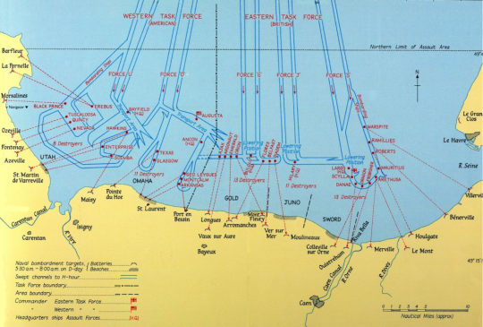


Maps for Operation Overlord, the Allied Invasion of Normandy, D-Day, June 6, 1944.
#History#Operation Overlord#D-Day#D-Day + 80 Years#D-Day 80#Invasion of Normandy#Normandy Landings#Battle of Normandy#Allied Invasion of France#80th Anniversary of D-Day#Maps#World War II#WWII#Second World War#Military History#D-Day Invasion#Allied Forces
44 notes
·
View notes
Text

From: Muḥammad ibn Muḥammad al-Idrīsī (محمد بن محمد الإديسي), Nuzhat al-mushtāq fi'khtirāq al-āfāq, [1154], 1250-1325 [Département des Manuscrits, Bibliothèque nationale de France, Paris. Library of Congress, Washington, D.C.]
#geography#map#illustration#book#muḥammad ibn muḥammad al idrīsī#tabula rogeriana#bibliothèque nationale de france#library of congress#1250s#1320s
36 notes
·
View notes
Text

The most common surname by region.[x]
Nice to see Basque surnames Etcheverry [meaning "new house"] and García [from gartzea "the young"] thriving in the south 🧡🧡
#euskal herria#basque country#pays basque#pais vasco#euskadi#france#surnames#euskera#euskara#basque#maps#culture
49 notes
·
View notes
Text
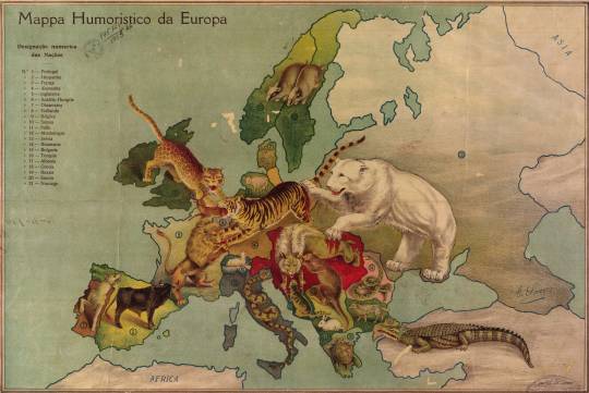
Animals represent European nations at the start of WW I. Humorous Map of Europe. 1914.
Library of Congress
593 notes
·
View notes
Photo
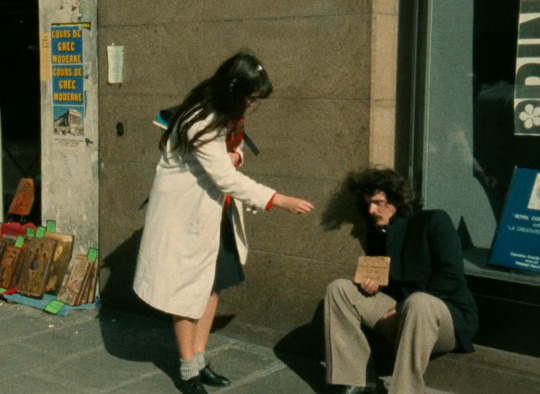
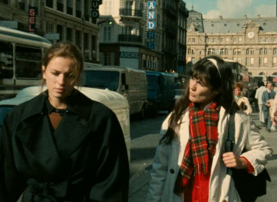
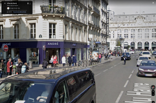
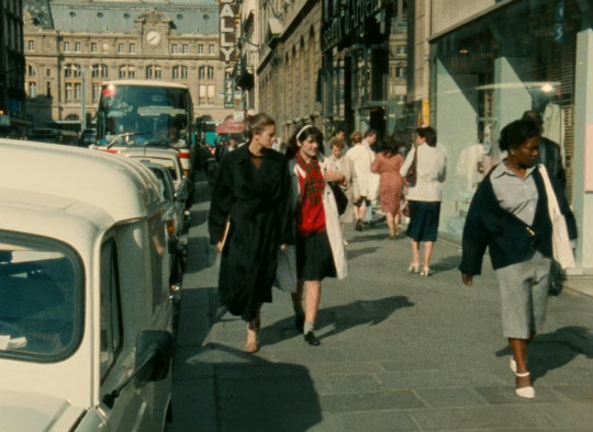
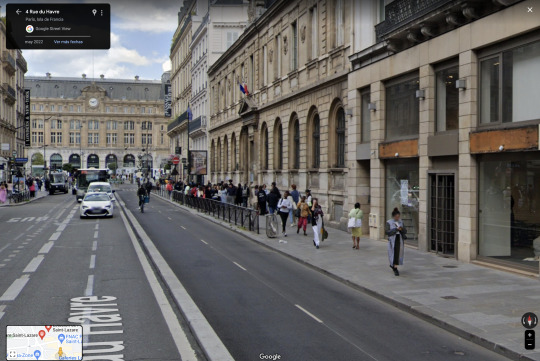
Quatre Aventures de Reinette et Mirabelle / Four Adventures of Reinette and Mirabelle
Éric Rohmer. 1987
Beggar 1
5 Rue du Havre, 75008 Paris, France
See in map
See in imdb
#eric rohmer#quatre aventures de reinette et mirabelle#four adventures of reinette and mirabelle#joëlle miquel#jessica forde#gare saint-lazare#gare saint lazare#paris#france#beggar#movie#cinema#film#location#google maps#street view#1987
26 notes
·
View notes
Text
selenthal / In Singrist, France
I think I probably belong in one of these German sounding tiny French towns
#photography#visual archive#design#art#mine#liminal#aesthetic#places#france#google maps#geoguessr#geography#weirdcore#webcore#liminal spaces#screenshot#europe#landscape#surreal
20 notes
·
View notes
Text

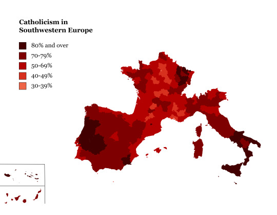

Catholicism (practicing & non-practicing) in North America, Southwest Europe, United Kingdom, and Ireland
#map#maps#cartography#usa#mexico#latin america#data#americas#europe#geography#catholicism#catholic#cathblr#uk#ireland#irish#spain#cuba#canada#france#italy#christian#christblr#christianity
164 notes
·
View notes
Photo
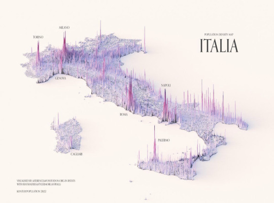


334 notes
·
View notes
Photo


Four ways to divide France into two parts with the same number of inhabitants.
On the 4 maps, as many people live in the orange zone as in the blue zone
via JulesGrandin
498 notes
·
View notes
Last Seen Blogs

alaskarostova
Oh my god what am I doing

mona-vanderdoll
“Lions And Tigers And Bitches Oh My!”
jsfinnnn
JS

angelodeval
Angelo DeVal - Photographer

wearevillains
iris