#mercalli earthquake scale
Text
Watching this for the ♾️th time. It’s probably the earliest thing I can clearly remember watching on TV.
youtube
I love when the line is blurred between sound and music. Sound effects done in music like Disney’s Fantasia and Peter & the Wolf.
I like it just as much, if not more, when sound effects are used to make music, like in the background music here. This whole movie has so much to unpack.
youtube
Or better yet!
youtube
Sound waves don’t intend to be one thing or another. We can make them be music if we craft them in the correct way.
Same thing with speech. You’re just making noises and crafting them to sound like something. Just make a symphony of noises at the right frequencies to make words and play it for him. Then he can gradually put together a blend of sounds or just summon up the right frequencies to create speech.
youtube
I was today years old when I learned that Dr. Seuss wrote it.
That bit when Gerald suddenly goes BOOM and traumatizes his dad reminds me of all the things I would recite when I was a kid. Things from all of the cartoons I watched to my well loved encyclopedia.
One favorite was the Mercalli Earthquake scale. I remember coming up from the basement like
🧒🏼
“I: Not felt by people, but recorded by instruments. Animals may be uneasy. Doors may swing slowly. II: May be felt by a few people indoors, particularly those on upper floors. III: Felt indoors by some as a rapid…”
And hearing my parents just sounding like Tina Belcher going “Uhhhhhhhh…”
It feels good to make certain frequencies.
I wonder if that is why some kids scream when it seems like there is no reason.
#hemp#yellow fruit stripes#megalodon#selfish giant#brave little toaster#ghostbusters#Gerald mcboingboing#bobs burgers#mercalli earthquake scale#Youtube
1 note
·
View note
Text
Aftermath of Chicxulub impact if the dinosaur-killer asteroid strike happened today. See video description for sources of data/latest articles.
youtube
If you skim forward, be sure to check the end where it speeds up to cover longterm effects.
Ejecta means "stuff tossed out," both from the impactor and the ground.
There's a lag before the tsunamis start. I'm guessing that's because the ocean has to fill the hole in it caused by water simply vaporizing, then the 180 km wide, 20-km deep crater in the Earth's crust, before it can rebound.
The "thermal impact" chart has a heat scale on the left and a luminosity scale on the right, "radiant flux," measuring how many times brighter it is than the Sun.
See below for a key to the the earthquake intensity scale they're using, which you may have seen on "Did you feel it?" shakemaps produced by the USGS.
This simulation suggests the earthquake subsides after about half an hour (YIKES), but recent studies hint the Earth may have quivered for days, even months.
The video's caption says the earthquakes are color-coded using the MSK earthquake intensity scale, common in Europe, Russia, and the Middle East. But when I checked the links in the video description, it turned out the software they're using simulates the Modified Mercalli intensity used in the Americas.
It doesn't really matter. As you can see from the two charts below, they're basically the same.
Medvedev–Sponheuer–Karnik scale

From Wikipedia.
Modified Mercalli scale

9 notes
·
View notes
Text
FTF Calculations: Befriendus Mituna takes Beforus and pushes it somewhere else.
Feat source: (Feat starts 36:30)
youtube
In the second bad ending for Mituna's route in Befriendus, Mituna will attempt to move Beforus in an attempt to avert the apocalypse.
Despite what I named this, he does not succeed in moving the planet to any considerable degree. What he does do is light up the entire world and make the entire planet quake, so let's calc that instead.
Now, starting with illumination. It took me fucking forever to find a formula that could properly estimate how much energy I'd need to fully illuminate a specific area, but I think I've found something that works. In order to estimate how many watts are needed to properly illuminate a provided space, home renovaters typically use the formula length x width x 1.5. So, assuming Beforus has the same dimensions as the Earth that would be 41850395.04 ft times 41711287.424 ft times 1.5. This gets us... 625 kilotons. Only Large Town.
To be fair, this is my first time calculating illumination, so cut me some slack if it's not entirely accurate. If anyone knows a better method, please tell me. I'll admit I'm still very new to the calcing game.
As for the Earthquake, the entire world is described as moving and buildings miles away are decribed as shaking. This imples that the entire world felt a Magnitude VII on the Mercalli Scale, or a magnitude 5 on the Richter. Accounting for Beforus's assumed radius of 6563 km, we get a total energy if 2.1 teratons of tnt, or Small Country Level. Much better. That is a level I am more confident in.
Sadly, this doesn't scale to anyone in canon because, well, fan game and Sollux has better feats in canon regardless, but it is a nice feat to have on hand regardless.
Illumination: 625 Kilotons (Large Town Level+)
Shaking: 2.1 Teratons (Small County Level)
10 notes
·
View notes
Text
Shattered Ground: The 2010 Canterbury Earthquake
On the early morning of September 4, 2010, the South Island of New Zealand was jolted awake by a powerful 7.1 magnitude earthquake, now known as the Canterbury or Darfield earthquake. Striking at 4:35 am local time, it was one of the most significant seismic events in New Zealand's recent history. With a maximum intensity of X (Extreme) on the Mercalli scale, the quake unleashed a wave of destruction that reverberated through the region.

Initial Impact and Damage
The earthquake’s epicenter was located near Darfield, about 40 kilometers west of Christchurch, New Zealand's second-largest city. At a depth of just 10 km, the quake caused extensive damage and left residents grappling with power outages. Remarkably, while there were serious injuries—two from falling debris and flying glass—there were only two fatalities. The timing of the quake, early in the morning, and the relatively modern construction of many buildings helped limit the death toll.

The quake was followed by several powerful aftershocks, including a 5.8 magnitude foreshock just seconds before the main event. The tremors were felt across the South Island and even reached parts of the North Island. Despite the shaking, no tsunami was triggered, as the epicenter was situated inland.
Response and Recovery
In the aftermath, New Zealand's National Crisis Management Centre was activated, and a state of emergency was declared for Christchurch and surrounding areas. The New Zealand Army was deployed to assist with recovery efforts, and initial curfews were set for affected areas. The cost of insurance claims ranged between NZ$2.75 and $3.5 billion, with the total damage estimated to reach up to $40 billion, marking it as one of the most expensive natural disasters in recent history.
The Geology Behind the Quake
The 2010 quake was a result of strike-slip faulting within the Pacific plate’s crust, near the Southern Alps’ eastern foothills. The earthquake’s complex nature involved multiple faults and was linked to regional seismic activity. The peak ground acceleration (PGA) recorded was 1.26 g, an extremely high value for such a fault rupture.
Aftershocks and Ongoing Impact
The aftershocks were relentless, with over 11,000 recorded by August 2012. Significant aftershocks included a 6.3 magnitude quake in February 2011, which devastated Christchurch, causing 185 deaths and massive damage. Other notable aftershocks occurred throughout the year, continuing to affect the region and complicate recovery efforts.
Financial and Structural Aftermath
The financial impact of the earthquake was staggering, with estimates of total costs reaching up to NZ$4 billion. Insurance and reinsurance companies faced substantial claims, with the Earthquake Commission (EQC) covering domestic residences and private insurers handling additional costs. This earthquake was the fifth most costly insurance event globally since 1953.
The 2010 Canterbury earthquake remains a significant event in New Zealand's history, showcasing the region's vulnerability to seismic activity and the resilience of its people. The recovery from this disaster highlighted the importance of preparedness and the need for ongoing efforts to mitigate future risks.
0 notes
Text
How are earthquakes measured and reported?
Earthquakes are measured and reported using a combination of seismological instruments, scales, and reporting systems. Here’s an overview of how this process works:
1.Seismometers and SeismographsSeismometers: These keen devices track and identify ground motion brought on by seismic waves produced by an earthquake. Both tiny and huge earthquake tremors can be measured by them.
Seismographs: These gadgets create seismograms, which show the frequency and amplitude of the seismic waves, by recording the data gathered by seismometers on paper or digital media.
2. Wave TypesPrimary Waves (P-waves): These are the initial and quickest seismic waves. They pass through both liquids and solids.
Secondary waves, or S-waves, are waves that only pass through solids and arrive after P-waves. The time of their arrival aids in locating the earthquake.
Surface Waves: During an earthquake, these waves typically cause the most damage because they move along the Earth's surface.
3. Magnitude RankingsRichter Scale: Developed in the 1930s, this scale gauges the size of an earthquake by measuring the amplitude of seismic waves. Because it is logarithmic, a tenfold increase in wave amplitude is represented by each whole number increment.
Moment Magnitude Scale (Mw): This is the most commonly used scale today, providing a more accurate measure of an earthquake's size by considering the fault area, slip, and the rigidity of rocks.
Modified Mercalli Intensity Scale: This scale measures the intensity of shaking and damage caused by an earthquake, using observations from people and structural damage rather than seismic data.
4. Choosing a LocationTriangulation: Information from at least three seismograph stations is utilized to determine the epicenter of an earthquake, which is the location directly above the focus. Each station's distance from the epicenter is found by measuring the interval between the arrival times of P- and S-waves. The position of the epicenter can be found by triangulating these distances.
5. Systems of ReportingSeismological Networks: Companies such as the United States Geological Survey (USGS) and other international networks keep a close eye on seismic activity and offer data and analysis in real time.
Public Alerts: Websites, social media, and alarm systems are just a few of the ways that the general public is informed about earthquakes. In populous regions, early warning systems can send out signals seconds before the ground starts to shake.
6. Data Analysis and ResearchAftershock Monitoring: Following a significant earthquake, seismologists monitor aftershocks, which can be numerous and vary in magnitude.
study Studies: In order to better understand seismic activity, develop building codes, and increase earthquake preparedness, data from earthquakes is used in continuing study.
7. Global CollaborationInternational Networks: To exchange data and enhance earthquake monitoring worldwide, nations work together via networks such as the Global Seismographic Network (GSN).established Reporting: To guarantee uniformity in the measurement, reporting, and interpretation of earthquakes worldwide, organizations adhere to established procedures.
Conclusion
Through a combination of advanced technology, established scales, and collaborative efforts, earthquakes are accurately measured and reported, helping to enhance public safety and understanding of seismic activity.
#EarthquakeMeasurement#Seismology#RichterScale#MagnitudeScale#Seismograph#Pwaves#Swaves#Epicenter#MomentMagnitude#EarthquakeReporting
0 notes
Text
Events 2.24 (after 1920)
1920 – Nancy Astor becomes the first woman to speak in the House of Commons of the United Kingdom following her election as a Member of Parliament (MP) three months earlier.
1920 – The Nazi Party (NSDAP) was founded by Adolf Hitler in the Hofbräuhaus beer hall in Munich, Germany
1942 – Seven hundred ninety-one Romanian Jewish refugees and crew members are killed after the MV Struma is torpedoed by the Soviet Navy.
1942 – The Battle of Los Angeles: A false alarm led to an anti-aircraft barrage that lasted into the early hours of February 25.
1945 – Egyptian Premier Ahmad Mahir Pasha is killed in Parliament after reading a decree.
1946 – Colonel Juan Perón, founder of the political movement that became known as Peronism, is elected to his first term as President of Argentina.
1949 – The Armistice Agreements are signed, to formally end the hostilities of the 1948 Arab-Israeli War.
1967 – Cultural Revolution: Zhang Chunqiao announces the dissolution of the Shanghai People's Commune, replacing its local government with a revolutionary committee.
1968 – Vietnam War: The Tet Offensive is halted; South Vietnamese forces led by Ngo Quang Truong recapture the citadel of Hué.
1971 – The All India Forward Bloc holds an emergency central committee meeting after its chairman, Hemantha Kumar Bose, is killed three days earlier. P.K. Mookiah Thevar is appointed as the new chairman.
1976 – The 1976 constitution of Cuba is formally proclaimed.
1978 – The Yuba County Five disappear in California. Four of their bodies are found four months later.
1981 – The 6.7 Ms Gulf of Corinth earthquake affected Central Greece with a maximum Mercalli intensity of VIII (Severe). Twenty-two people were killed, 400 were injured, and damage totaled $812 million.
1983 – A special commission of the United States Congress condemns the Japanese American internment during World War II.
1984 – Tyrone Mitchell perpetrates the 49th Street Elementary School shooting in Los Angeles, killing two children and injuring 12 more.
1989 – United Airlines Flight 811, bound for New Zealand from Honolulu, rips open during flight, blowing nine passengers out of the business-class section.
1991 – Gulf War: Ground troops cross the Saudi Arabian border and enter Iraq, thus beginning the ground phase of the war.
1996 – Two civilian airplanes operated by the Miami-based group Brothers to the Rescue are shot down in international waters by the Cuban Air Force.
1999 – China Southwest Airlines Flight 4509, a Tupolev Tu-154 aircraft, crashes in Rui'an, Zhejiang, China. All 61 people on board are killed.
2004 – The 6.3 Mw Al Hoceima earthquake strikes northern Morocco with a maximum Mercalli intensity of IX (Violent). At least 628 people are killed, 926 are injured, and up to 15,000 are displaced.
2006 – Philippine President Gloria Macapagal Arroyo declares Proclamation 1017 placing the country in a state of emergency in attempt to subdue a possible military coup.
2007 – Japan launches its fourth spy satellite, stepping up its ability to monitor potential threats such as North Korea.
2008 – Fidel Castro retires as the President of Cuba and the Council of Ministers after 32 years. He remains as head of the Communist Party for another three years.
2015 – A Metrolink train derails in Oxnard, California following a collision with a truck, leaving more than 30 injured.
2016 – Tara Air Flight 193, a de Havilland Canada DHC-6 Twin Otter aircraft, crashed, with 23 fatalities, in Solighopte, Myagdi District, Dhaulagiri Zone, while en route from Pokhara Airport to Jomsom Airport.
2020 – Mahathir Mohamad resigns as Prime Minister of Malaysia following an attempt to replace the Pakatan Harapan government, which triggered the 2020-2022 Malaysian political crisis.
2022 – Russo-Ukrainian War: Days after recognising Donetsk and Luhansk as independent states, Russian president Vladimir Putin orders a full scale invasion of Ukraine.
0 notes
Text
Magnitude 3.4 earthquake hits Huntington Beach, rattling nerves
A magnitude 3.4 earthquake hit underneath Huntington Beach on Friday night, rattling some nerves.
The earthquake struck at 9:52 p.m., with an epicenter just east of Newland Elementary School. According to the U.S. Geological Survey, there was light shaking at the epicenter as defined by the Modified Mercalli Intensity Scale, with the shaking intense enough to be felt indoors by many — feeling…

View On WordPress
0 notes
Text
Just to Know!
A recent earthquake of 6.4 magnitude hit Nepal on 3rd November 2023, followed by an aftershock, which has exposed significant shortcomings in emergency alert systems in and around Delhi.
Google’s Android Earthquake Early Warning System:
This is a feature that uses the sensors in Android smartphones to detect seismic activity and alert users about potential earthquakes.
It also collects and shares the data with seismological agencies to improve earthquake detection and analysis.
Google launched this feature in India in September 2023, in collaboration with the National Disaster Management Authority (NDMA) and the National Centre for Seismology (NCS), Ministry of Earth Sciences.
Google's alerts are triggered based on the Modified Mercalli Intensity (MMI) Scale, an alternative to the Richter scale.
The CBAS represents cutting-edge technology that empowers us to disseminate critical and time-sensitive disaster management messages to all mobile devices within specified geographical areas, regardless of whether the recipients are residents or visitors.
Common applications of Cell Broadcast include delivering emergency alerts such as severe weather warnings (e.g., Tsunamis, Flash Floods, Earthquakes), public safety messages, evacuation notices, and other critical information.
It is developed in collaboration with the Department of Telecommunications (DOT) and the NDMA and other agencies to generate and disseminate the alerts.
#earthquake#current events#current news#generalknowledge#general knowledge#affairsmastery#india#ssccgl#upscprelims2024#upsc#upscaspirants#upscexam#upscprelims#upsc2024#dailynews#generalknowledgeindia#google#mobile technology#technology#futurism
1 note
·
View note
Text
Game of Thrones filming sites and the September 8th Morocco earthquake. 🇲🇦
Several locations in Morocco were used for location filming in Game of Thrones. They were all affected by the recent earthquake though were not in the most severely struck area.
Essaouira served as Astapor in Season 3. It's located on the Atlantic coast. The effect of the quake in Essaouira was IV to VI on the Mercalli Scale which measures local intensity.
Aït Benhaddou filled in as Yunkai, another Slaver's Bay location from Season 3. Aït Benhaddou is about 22 km from Ouarzazate which is the home of Atlas Studios where some production took place. In Aït Benhaddou/Ouarzazate the quake measured VI to VII on the Mercalli Scale.
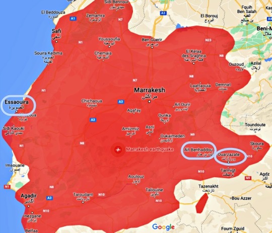
Here's Daenerys just outside Yunkai/Aït Benhaddou in S03E10.

In terms of lives lost and number of injuries, this is the second worst earthquake in Moroccan history. Many historical and culturally significant buildings were damaged or destroyed.
Morocco earthquake – live: Race to find survivors as death toll tops 2,901
CBS News has compiled a list of organizations providing relief to those affected by the earthquake and aftershocks. Keep in mind that local people were used as extras in those GoT Season 3 Morocco scenes.
How to help those affected by the earthquake in Morocco
#game of thrones#morocco earthquake#essaouira#astapor#aït benhaddou#yunkai#ouarzazate#المغرب#آيت بن حدّو#الصويرة#ورزازات#gra o tron#trône de fer#kampen om tronen#isang kanta ng yelo at apoy#hra o trůny#pemainan takhta#juego de tronos#jogo dos tronos#trono di spade#taht oyunları#гра престолів#왕좌의 게임#ゲームの玉座#صراع العروش#تخت کے کھیل#गेम ऑफ़ थ्रोन्स#משחקי הכס#игра престолов#παιχνίδι των θρόνων
0 notes
Text
did you guys know that aside from using the magnitude scale for earthquakes they also use the modified mercalli scale to measure the intensity of shaking produced by those earthquakes
and since magnitude and MM use different info to determine different things, you can have a pretty "weak" earthquake do some really fucked up damage (i.e a 2.2 magnitude quake in england back in 1865 had a MMI of VIII, which is 8 out of 12 on the scale)
#im gonna be really sad if i got something wrong#i feel like when i try and give information i dont do it very well
1 note
·
View note
Text
How earthquakes are measured | CNN
How earthquakes are measured | CNN
CNN
—
Earthquakes are measured using seismographs, which monitor the seismic waves that travel through the Earth after an earthquake strikes.
Scientists used the Richter Scale for many years but now largely follow the Modified Mercalli Intensity Scale, which the U.S. Geological Survey says is a more accurate measure of size.
The Richter scale measures magnitude, whereas the MMI scale…

View On WordPress
0 notes
Text
GAYS I WROTE ABT MARCY BEFORE CANON WRECKS MY SHIT LOL
Marcy liked people.
Sure, sometimes talking to them got tiring after a while, but she adored watching them.
She liked studying the intricate ways they interacted with each other, and she always marveled at the swift changes in their relationships.
She never had to worry about those things, her friendship with Anne and Sasha was as sturdy as the ground she walked on, so she observed and studied her classmates with the curiosity novelties always sparked in her.
Wait.
The ground! That was she was!
A geologist! A virtuous scientist of the movements of the tectonic plates in her class.
She didn't even know if that was the right word. She might have to look into the topic more, it seemed incredibly interesting.
Accurate or not, the world felt right. She danced over the fractures of relationships and jumped over the rifts between people and admired the fireworks of vulcanic rage's eruptions and-
What an incompetent geologist you were, wit .
Wha-
We said we don't believe in your capabilities in the geologic field, wit .
Oh, right. The Core was still there.
Such rudeness. We thought our presence would be less... forgettable, wit .
Forgetting about the crime against nature in her head might have sounded like an impossible task, but those memories were just so-
A testament to your blindness, wit .
Blindness? What a thought. Marcy took pride in being extremely thorough with her research. And her data was top notch! Apart from her own observation, she had Anne's first-hand and Sasha's blackmail material. It was absolutely fool pr-
Your thoughts range wildly from underestimating and overestimating yourself, wit . You're quite the complicated person, aren't you?
Human brains were bound to be complicated, Marcy had to learn it the hard way.
All brains are complicated, wit . But yours is a... jumbled mess? Is that how you younglings say that?
Great. So her consciousness was invaded by a boomer now.
We do not know what that is; but we do know, from the information we put together, that a geologist shouldn't leave any data out of the picture just to gain a false sense of security, wit .
The core was now walking in circles around her. It kept itself mostly as a nebulous shape, but it had its way of changing it when it was needed. The Core's pace was irregular, as if the support for its feet wasn't the same.
As if it was walking with only one shoe.
You are avoiding the problem with your research, wit .
Because it obviously had no problems.
It seems we must spell it out for you, wit . You disappoint us.
Andrias must have been truly slacking with his flipwart exercises.
Having gotten used to listening to the overlap of multiple voices at once, hearing only on at a time feld weirdly out of place.
Forgive our youngest, wit . Now tell us: would a good geologist have ignored earthquakes?
No and-
Where would you place on the scale the events in the castle then?
Oh.
Oh.
We'd say at least a 9 on Ritchter's scale. Should we use Mercalli's instead, wit? After all, that's the one used to measure damage, isn't it?
The damage. The damage she created.
She was truly a bad geologist, after all.
Look at how she clings to that stupid metaphor!
The Core threw its head back in the motion of a soundless laugh.
Some strands what looked like like a ponytail bounced on its back.
Does it give you comfort, wit? Did you think distancing yourself from everything that was happening would save you? Did you thinks that your safe ground would save you from drowning in the wretchedness of what you did?
Marcy's lip trembled. Her eyes got glassy.
The Core was right. She wasn't a terrible geologist. She was just a terrible frie-
No. You're worse than that. I think you're a terrible person, Mar-Mar .
Ao3 link <3
16 notes
·
View notes
Text
Groundbreaking (literally) not-fun facts about Greece
A history of earthquakes, not because it is pleasant, but because we (especially us Greeks) need to know it. Trigger warnings left and right, up and down.
I saw many different rankings so I chose the one that provided the most information. This site ranks Greece 8th in the world in terms of annual frequency of major earthquakes (0.28). Greece shares this frequency placement with Italy, Afghanistan, India and Mexico. Neighbour Turkey is even higher in this list.
Which means, Greece and Italy are the most seismic active countries in Europe.
Greece sits on top of three tectonic plates (poor thing). The Eurasian plate and the small Aegean sea plate are in the North and Center of Greece. These two move apart from each other. At the same time, in South Greece, the African plate pushes itself towards the Aegean Sea plate and sinks beneath it.
No earthquake with magnitude over 7.2 has been recorded instrumentally in Greece. Those big earthquakes usually occur in great depths where the African plate sinks under the South Aegean sea, which makes them not as disastrous as they could have been otherwise.
Greece has 157 active rifts that have caused 570 known earthquakes of magnitude bigger than 6.0. 53 of them took place in only three of the Heptanese islands, making them the most seismic region of Greece.
A few days ago two earthquakes from nearby rifts of magnitudes 6.3 and 6.0 and unusual duration in the region of Elassona has concerned scientists as “unexpected seismic behaviour”. Many buildings are evaluated as uninhabitable and one 83 year old man lost his life.
In October 2020, a 7.0 earthquake between the Greek island of Samos and the Turkish Gulf of Ephesus was ranked VIII in the Mercalli scale. Two teenagers were killed in Samos and Turkey suffered a tragic death toll of 114 people. The earthquake also caused a tsunami.
The Great Earthquake of Thessaloniki (1978) was a 6,5 tremblor with a focal depth of 6 miles and duration of 10 seconds. It was a VIII in the Mercalli intensity scale. Many thousands were left homeless and 49 people died. After that Greece started investing a lot in earthquake safety rules awareness as well as earthquake resistant civil engineering.
The largest earthquake in the last 50 years was a 7.1 tremblor in Agios Efstratios island, 1968.
In 1955, and in between many natural disasters, Volos city was hit by a 6.2 earthquake . Almost 70% of the city's houses were severely damaged or collapsed. Many of these houses were historical mansions that belonged to old families of captains and ship owners as Volos is a major port city. The state sent a great military and naval force to help rebuild the city. Within a year, the city's architectural profile had changed entirely forever.
The deadliest earthquake in the history of Modern Greece was a 7.3 earthquake that happened in Chios island in April of 1881 and had 7,866 fatalities.
In 1866, a 6.1 earthquake in Santorini, caused the Volcano of Nea Kameni to erupt and create two new islets. These are visited by tourists nowadays.
The biggest earthquake in the history of Modern Greece occurred in Rhodes island, in 12 October 1856. It is estimated that it had a magnitude of 8.2 and it lasted more than one minute. It destroyed entirely more than 3,200 houses and shook 10 other countries. It killed only 12 people because strong pre-shocks had already made people worry and exit their houses.
In December 856 AD, in Corinth, an earthquake of a magnitude we can only guess - but better not - killed 45,000 people.
In 226 BC, an earthquake of unknown magnitude toppled the Colossus of Rhodes, one of the 7 Wonders of the Ancient World.
An estimated 7.0 earthquake took place in the Euboic Gulf in 426 BC. The historian Thucydides concluded that the Malian Gulf tsunami of the same year was caused by the earthquake and he was the first to recognize such a link.
The earliest earthquake we know about from historical sources is an estimated 7.2 in Sparta, in 464 BC. It killed about 20,000 people.
More sources:
www.mixanitouxronou.gr
Σαν σήμερα στον 20ο αιώνα
Wikipedia
#greece#europe#tw natural disasters#tw earthquake#tw death#tw anxiety#history#greek history#greek facts#geology
41 notes
·
View notes
Text
I share a birthday with the 1303 Crete earthquake. It had an estimated magnitude of about 8, a maximum intensity of IX (Violent) on the Mercalli intensity scale, and triggered a major tsunami that caused severe damage and loss of life on Crete and at Alexandria.
2 notes
·
View notes
Text
earthquake in Banjaluka, 1969
was an earthquake of magnitude 6.4 on the Richter scale and intensity in the epicentral area of 8 degrees on the Mercalli scale, which occurred on October 27, 1969
An earthquake in 1969 devastated the city. 15 people from Banja Luka were killed, and 1,117 people were seriously and lightly injured. The material damage was enormous. 86,000 apartments were completely destroyed and great damage was inflicted on school (266), cultural (146), health (133), social and public administration facilities (152)
3 notes
·
View notes
Text
me bullshitin my way through eart sci
The intensity of the earthquake can vary from place to place depending on the distance of the place to the origin of the earthquake. This means the the origin of the earthquake came from some where near Quezon but far enough to only cause injuries, and far from Cavite but close enough to cause injuries. A magnitude high enough to cause injuries to a far away place, while being low enough to cause no deaths in a closer place. So the intensity of it the earthquake that hit Cavite City maybe 5-6 and Quezon City has an intensity of 6-7. And let's say it's from the West Valley Fault and it originated in Makati, so that's about 6.0-6.9, at the very least. So, since we identified the probable intensity and magnitude, let's extrapolate more. 5-6 intensity on the Modified Mercalli Intensity scale says that 5 felt nearly by everyone, and some fragile objects may brake, 6 is felt by all and has a few instances of fallen plaster, and 7 has slight to moderate damage on well-built ordinary structures and some chimneys be broken.
2 notes
·
View notes
Last Seen Blogs

foggyfanpainter
いつかの自分へのメッセージ😄 Shout soliloquy

squircular7
SQUIRCULAR™: An Actor's Tale BLOG

foffimreading
F.off.im.reading

bestgrishaversequotes
iconic grishaverse quotes

indiia1-blog
Uma Menina Mulher