#remutaka
Text

The route to Beau Vista orchard over the Remutaka Pass. A 3 day march for these soldiers.
The Nineteenth Reinforcements are marching over the Remutaka Pass from Featherston Camp to Trentham Camp on 26 Oct 1916 photo James Daroux
Over 30,000 soldiers marched over this pass in WW1 #cider #remutaka #wairarapa
0 notes
Text
Wellington
We set off early from our nights lodgings and crossed the Remutaka hills without the rain, though we did see a fabulous rainbow in the distance. This hill crossing is not for the faint hearted and I am glad the weather was kind as I can't imagine doing this in poor weather or mid winter.
On arrival in Wellington we made our way to the two main locations of the Parliament building and the cable car as most people would. we are back in Wellington briefly again after our South Island trip so will do some other things then.
Spot the iconic cable car pic........
0 notes
Text
Mt McKerrow Loop (the hard way)
A return visit to Mt McKerrow, a 706m high viewless mountain (from the summit at least) in the Remutaka Ranges, to the east of Wellington. Last year’s hike to the summit from the usual starting point of Catchpool Valley in the south was straightforward. A return visit via backcountry trails to the north and west of the summit was the opposite, an 11 hour adventure along steep, rough and poorly…

View On WordPress
#day tramp#day walk#Hike#Hiking#McKerrow Track#Mt McKerrow#Mt McKerrow Loop#photography#Remutaka#Remutaka Forest Park#Remutakas#Rimutaka#Rimutakas#Scholes Creek#Tramp#travel#Walk#Wellington#Wellington day walk#Whakanui Track
1 note
·
View note
Text
Island Bay to Mount Albert
Starting from Island Bay, I walked round to Houghton Bay following the signposted Southern Walkway.

I have only ever cycled along this part of the coast, so it was nice to see it both on foot and heading in the other direction (I only cycle westbound but walked eastbound).

At Houghton Bay turn up the valley and head for Buckley Reserve. It's not a super obvious entry to the Southern Walkway and but just cross the grass field and trust me that it becomes clearer.

Up above Houghton Bay you reach a ridgeline offering expansive views cross to Lyall Bay and the Cook Strait. If you're lucky you can catch the Interislander entering the harbour.


Continuing on, you reach Mount Albert, a favourite spot of mine for watching planes coming in and out of Wellington Airport.


Mount Albert also gives views across Miramar over to the East Harbour and the Remutakas.
[28 May 2022]
#wlg22#wellington#poneke#te whanganui a tara#aotearoa#new zealand#southern walkway#island bay#houghton bay#mount albert#remutaka#harbour#airport#planespotting#ferry#interislander#cook strait
1 note
·
View note
Text
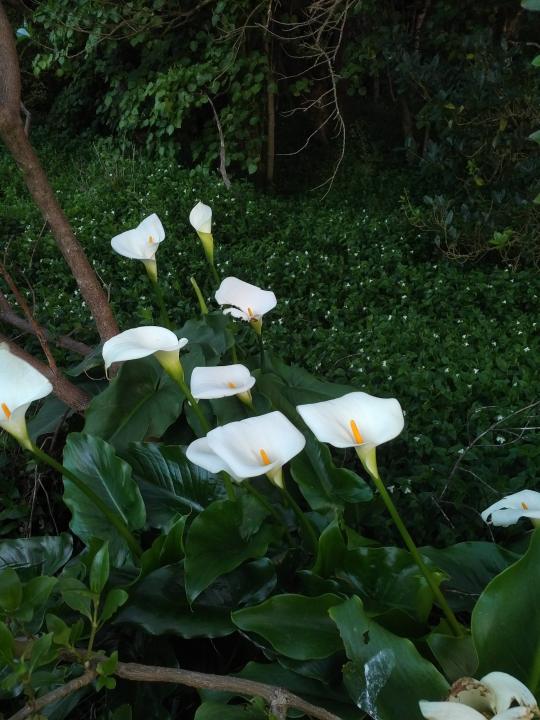
Calla lilies (Zantedeschia). Remutaka Forest Park, Wairarapa, Aotearoa. 9 Oct 2022.
10 notes
·
View notes
Photo

State Highway 2 between Featherston and Remutaka Pass, Wellington region, New Zealand by Mike Davidson
1 note
·
View note
Text
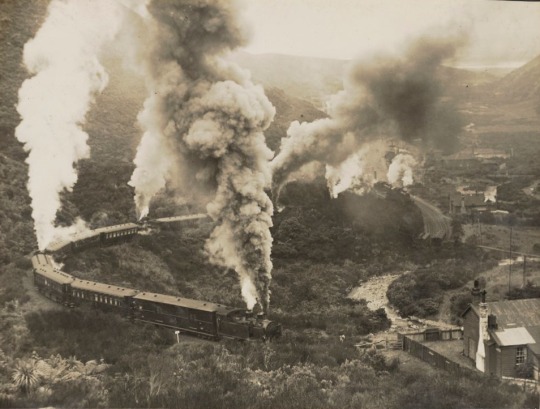
Train on the Remutaka Range, 1925-1935
124 notes
·
View notes
Text
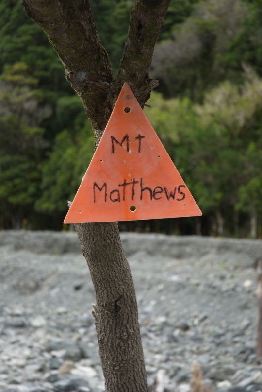
Mount Matthews
Jest taka góra, którą widać od nas z domu (no, prawie, trzeba wyjść na ulicę), a która już od dawna drażniła nas swoją obecnością, a raczej bardziej naszą na niej nieobecnością: Mount Matthews (942 m n.p.m.), najwyższy szczyt Remutakas. Chciałem ją zdobyć tym bardziej, że poprzednia próba, w sierpniu, nie udała się z braku czasu i musiałem zawrócić z trasy.

Mount Matthews z Orongorongo Valley.
Na Mt. Matthews trzeba poświęcić cały dzień — 24 kilometry po zupełnym odludziu, z przekraczaniem strumieni i częściowo bez ścieżki, wzdłuż dolin po żwirze rzecznym, z sumą podejść ponad 1200 metrów.
Zaczęliśmy o 6:30. Kilka minut później odbił się echem huk odrzutowca — domyślilismy się, że to ten 6:35 do Christchurch, którym za 2 miesiące polecimy. Strasznie wcześnie!

Orongorongo River
W godzinę doszliśmy do doliny Orongorongo, a następną zajęło nam przejście wzdłuż jej, do odbicia szlaku na południe. Do tej pory droga była łatwa, o łagodnym nachyleniu. Przejście rzeki również okazało się proste i szybkie — wody było o wiele mniej niż ostatnim razem i dało się przeskoczyć po kamieniach, bez zdejmowania butów (co bardzo opóźnia marsz, zwłaszcza gdy trzeba to zrobić kilka razy).
Podejście pod Mt. Matthews początkowo prowadzi korytem potoku, lewego dopływu Orongorongo. Nie ma ścieżki, drogę trzeba znaleźć wśród jego licznych koryt, na szczęście też o tej porze roku przeważnie suchych.

Po kilkuset metrach wchodzimy do buszu i zaczyna się konkret. Wchodzimy na porośniętą drzewami ścianę. Szlak niemal z miejsca staje się niewiarygodnie stromy — miejscami jest to drabina z korzeni, podobna do podejścia pod Waligórę z Andrzejówki, tylko wielokroć dłuższa. Szybko nabieramy wysokości.


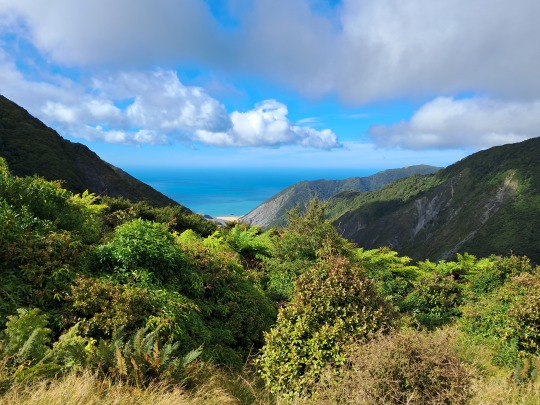
Niespecjalnie coś widać. Busz jest gęsty. Po około godzinie pokonujemy pierwszą część ściany, do przełęczy Southern Saddle. Za nią błyszczy lazur Palliser Bay na wschodzie i Wellington Bay na zachodzie.

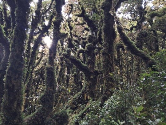
Z przełęczy jeszcze godzina na szczyt. Przyjdzie nam iść w klimatycznym lesie: przez cały rok jest tu tak wilgotno, że mchy łapią wilgoć z opływających Mt. Matthews chmur i szczelnie opatulają drzewa. Mimo że to najsuchsza pora roku, to i tak korzenie są mokre i śliskie. Musieliśmy się ich niekiedy łapać, bo tu też były bardzo strome fragmenty.
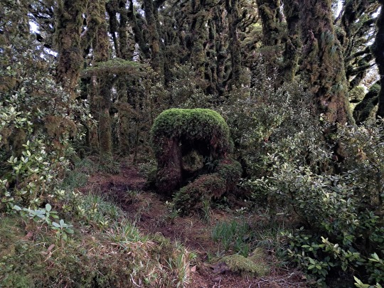
Jest trochę miejsc widokowych, ale ograniczonych drzewami.

Południowa Dolina Wairarapa.

W końcu docieramy na szczyt, skąd pięknie widać całą południową plażę przy Palliser Bay. Jest 11:15, czyli dwunastokilometrowa wędrówka zajęła nam 4h45m.

Na szczycie zostajemy 15 minut, potem schodzimy tą samą drogą. Przy tak dużym nachyleniu nie jest dużo szybciej, niż pod górę. Zejście do Orongorongo zajmuje nam 2h20m. W tym czasie pogoda robi się lepsza; niskie chmury zanikają, odsłaniając szczyty.

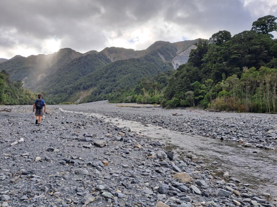
Dolina Orongorongo ma charakter roztokowy — rzeka ciągle zmienia swój bieg, nadsypując kolejne warstwy żwiru i kamieni. Skąd się one biorą? Ano stąd, z osuwisk takich jak poniżej.
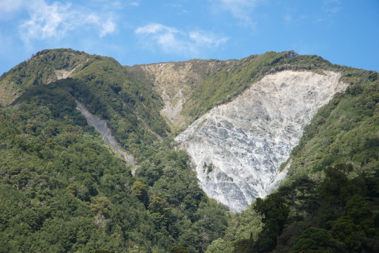
I to już wszystko. Do auta docieramy kwadrans po czwartej, całość zajęła nam zatem prawie 10 godzin. Pokonaliśmy 25 km i 1200 metrów do góry.
3 notes
·
View notes
Text
Revelations are made, gifts are given, miscommunication ensues... will these two work it out?
Non-spoilery snippet from the latest update below the cut!
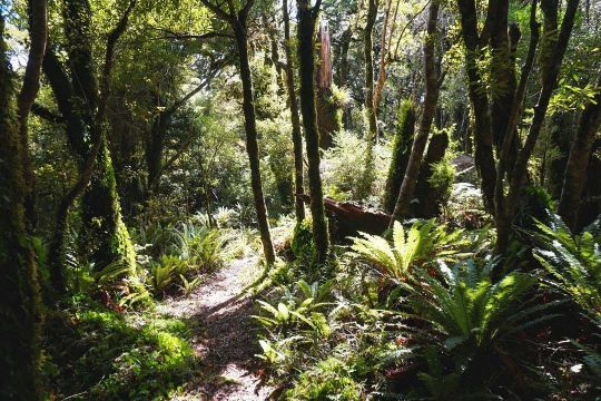
"Welcome to the Remutaka Forest Park," Anton announces, smoothly transitioning into what Viago presumes is his professional voice. A casual smile graces his face as he makes the aside, "I'll be going over some ground rules, so if you could just bear with me for a second, that'd be awesome."
Viago nods wordlessly. He is captivated by this side of Anton that he has not seen before.
“Right,” the other man's timbre deepens again. “You’re gonna be going in there with me, but if you manage to get lost, always remember," he puts up his index finger, "'Chinstrap tight, keep it in sight, back to marked trails, all will be right'!"
The vampire marvels. "Is this a rhyme that you have come up with yourself?"
"Yeah, you like that?" Anton breaks into a satisfied grin, briefly abandoning his formal tone again. "Oh, sorry, just one more thing - if we see any wildlife, remember that we have to be respectful, keep a safe distance, and don't make any loud noises. And please avoid using flashlights or camera flashes, as that can disturb - er,” he wavers. “Well, I mean, I know you won’t do that, you and I don’t need flashlights, but just -” he clears his throat, “Anyway, just respect Mother Nature and stick with me, alright?”
Viago puts a hand to his forehead in a salute. "Aye aye, captain!"
“Alright, no need for that,” the other man chuckles playfully, swatting the air with his hand.
#vianton#viago x anton#fic update#ao3#wwdits#what we do in the shadows#wwdits 2014#viago wwdits#anton the werewolf#viago von dorna schmarten scheden heimburg#romcom#lo and behold a fic update!#only took me the better part of a year#oops#ofmd references#long fic#vampires and werewolves#ofmd parallels#wwdits anton#wwdits viago#mutual pining#enemies to friends to lovers
5 notes
·
View notes
Note
4, 22, 24 🌱🌱❤️❤️❤️❤️❤️❤️❤️ happy new year ❤️❤️❤️❤️❤️
thank you my beloved ❤️❤️❤️
Favorite place you visited this year?
okay this is going to sound dumb as fuck to the wellington mutuals but. wainuiomata. i drove over the eastern hutt hills for the first time this year and first of all, that road just feels like a phenomenal bit of engineering, and second of all, when you crest over the hill and you just see wainuiomata sitting in that basin in between the hills and the bottom of the remutakas, i don't know! it makes me feel something! it feels like this little hidden secret completely divorced from the rest of wellington (i felt the same way the first time i drove to eastbourne, and just followed the road as far as i could). it's obviously not hidden, it's a reasonably sized suburb in wellington, but i did the same thing here that i did in eastbourne, which was to follow the road as far as it could go (i have now seen nearly all of the major lighthouses at the bottom of the north island, though we didn't actually go up to the baring head lighthouse, but that is a goal for this year). i just really really like it there. i like the football park, i like the coast road, i like that when you come back up over the hutt hills from the first time, even the most cynical of wellington will say "oh woah" when they see all of lower hutt laid out below and the complete view of the harbour.
Did you keep any New Year’s Resolutions?
i don't know if i even had any new year's resolutions. i wanted to do a few things, the main among them buying an engagement ring (which i did!), but i don't think i had any real resolutions. i did NOT finish nanowrimo (yet again), but this year i would really like to finish the first draft of this thing i've been working on since literally 2015. just to prove it to myself if nothing else.
4 notes
·
View notes
Photo

The road to the orchard. During WW1 over half of the soldiers deployed by New Zealand had to march over Remutaka mountain range from Featherston Training Camp to Wellington so they could embark ships bound for Europe and the Middle East. For many it would be the last time they were home. A gruelling but scenic and beautiful march , on a road that still winds through a pass in the mountains that separates Wellington from the Wairarapa region. #cider #ww1 #soldiers #remutaka #wairarapa https://www.instagram.com/p/CqJJtjaSTWF/?igshid=NGJjMDIxMWI=
0 notes
Link
Discover the Remutaka Ranges' rich rail history & natural beauty, the meandering Hutt River trail, and the beautiful Eastern Bays. Taking in some of the best parts of the the Remutaka Cycle Trail, this is a challenging ride with a steep uphill climb to begin with. 65km of moderate riding. #Tours2Go #ToursToGo
#CulturalThemeTours#HeritageTour#HistoricalHeritageTours#NewZealandToursTravel#NorthIsland#Tours#Wellington
0 notes
Photo
Another batch of photos from Saturday’s epic eleven hour hike in the Remutakas, to up the summit of Mt McKerrow the hard way!#remutakaranges #tramping #daywalk #remutaka #wellywalks #mckerrow #mtmckerrow (at Remutaka Forest Park) https://www.instagram.com/p/CptsE0zrEjA/?igshid=NGJjMDIxMWI=
0 notes
Text
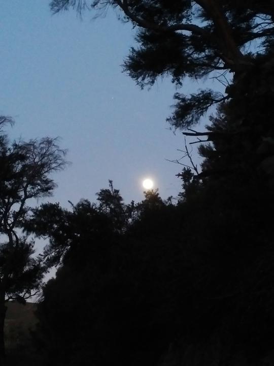
Full moon and Jupiter at nightfall. Remutaka Forest Park, Wairarapa, Aotearoa. 9 Oct 2022.
5 notes
·
View notes
Text
Bez jaj
W bardzo ciepłe środowe popołudnie wyskoczyliśmy w Bellmont Hills, skąd ostatnio pogoniły nas byki. Startowaliśmy z tego samego parkingu, ale poszliśmy w przeciwną stronę pętli, którą zamierzali byliśmy przejść uprzednio.
Tym razem, zamiast zejść dziką doliną strumyka pomiędzy wzgórzami, poszliśmy prosto na zachód, asfaltową drogą prowadzącą wzdłuż pastwisk, odgrodzoną drutem po obu stronach. Obracając się na wschód mogliśmy spojrzeć na Remutakas.


Po przejściu przełęczy na zachodzie ukazała się Porirua ze swoją zatoką.

Spotkaliśmy też kilka koni i jednego miłego farmera, z którym ucięliśmy pogawędkę. Opowiedzieliśmy mu o naszym odwrocie "po byku", na co on zapewnił nas, że ma z bykami do czynienia codziennie i one są po prostu ciekawskie, ale nie agresywne - bo są kastrowane. Brzmiało to rozsądnie, jednak pokazał nam też na ręce bliznę po krowim rogu, mówiąc że wypadki zdarzają się niezmiernie rzadko.
Mam mieszane uczucia.

Widzieliśmy go jeszcze chwilkę później, na quadzie. Podążała za nim gromadka psów.

Na zakończenie autoportret rodzinny:

4 notes
·
View notes

Last Seen Blogs

susancampbelljewelry
Susan Campbell Jewelry

theyhavemademe
the books I've read, they have made me

gypsy-gent
Untitled

stonytrumpshate
STONY TRUMPS HATE

slightlyworriedpitch-blog
The Art Blog Equivalent To A Rainy Day